
Heat expands across the Desert Southwest, Plains, Mississippi Valley and Midwest into Monday. Fire weather concerns continue for portions of the Intermountain West. Active monsoonal moisture fuels thunderstorms over the Southwest with possible flash flooding. Tropical cyclone Fausto in the Pacific, should weaken as it approaches Hawaii; Dangerous surf, swells and rip currents are expected. Read More >
Overview
During the evening of June 21, 2015 a supercell traveled across Harding, Perkins, and Ziebach Counties in northwestern South Dakota, bringing large hail, strong winds, and six tornadoes. Hail to the size of baseballs was reported 7 miles southeast of Meadow with numerous reports of golfball size hail near Bison and Meadow. Eyewitness spotter and chaser reports confirmed six distinct touchdowns with this supercell. The tornadoes remained in mainly rural areas of Perkins and Ziebach Counties with little to no damage being reported.
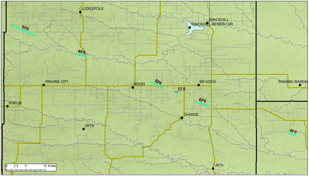
Tracks for all six reported tornadoes.
Tornadoes:
|
Tornado - North-Northwest of Prairie City, SD
Track Map 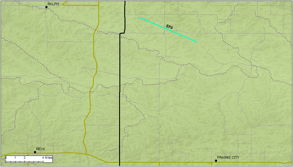  |
||||||||||||||||
|
Tornado - Northeast of Prairie City, SD
Track Map 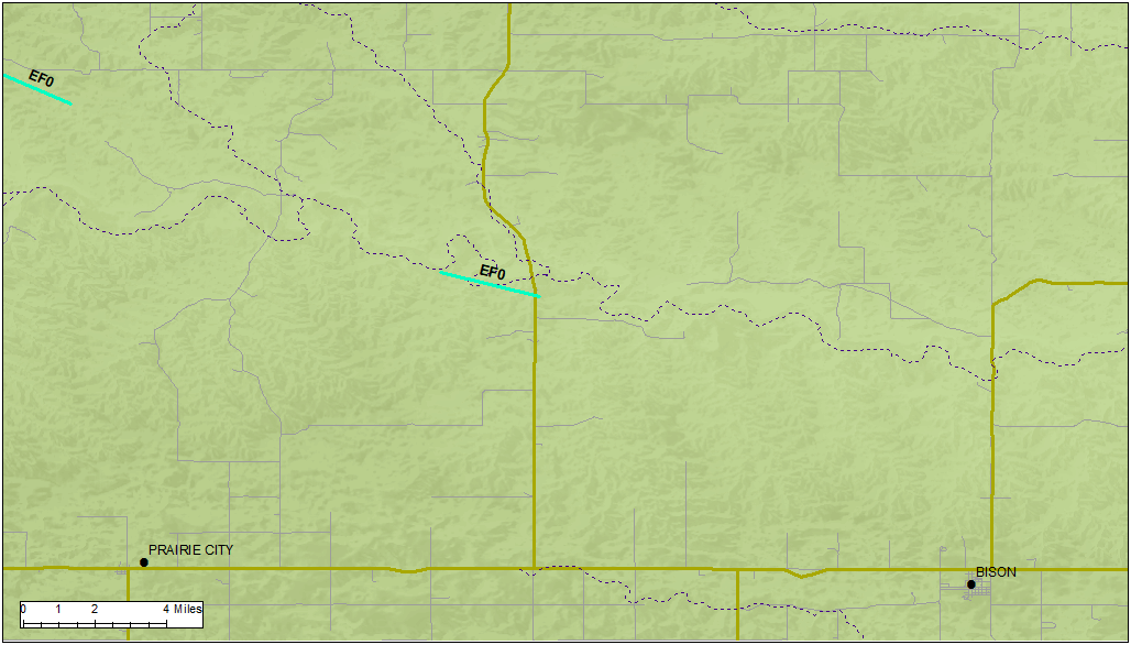 |
||||||||||||||||
|
Tornado - East of Bison, SD
Track Map 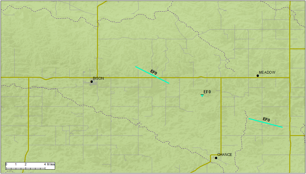 |
||||||||||||||||
|
Tornado - North of Chance, SD
Track Map 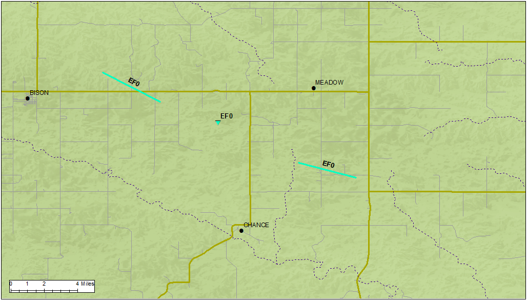 |
||||||||||||||||
|
Tornado - Northeast of Chance, SD
Track Map 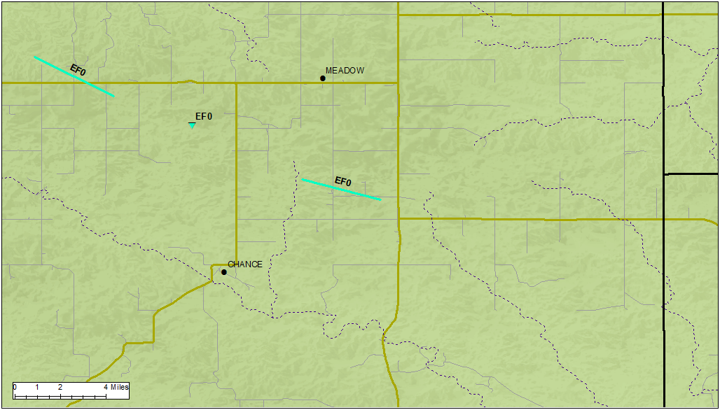 |
||||||||||||||||
|
Tornado - Southwest of Glad Valley, SD
Track Map 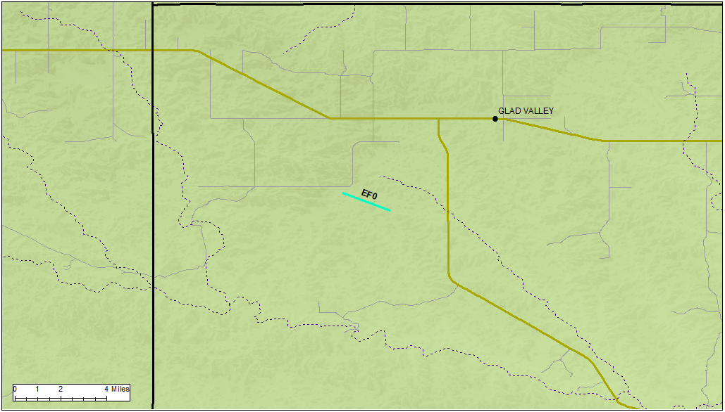 |
||||||||||||||||
The Enhanced Fujita (EF) Scale classifies tornadoes into the following categories:
| EF0 Weak 65-85 mph |
EF1 Moderate 86-110 mph |
EF2 Significant 111-135 mph |
EF3 Severe 136-165 mph |
EF4 Extreme 166-200 mph |
EF5 Catastrophic 200+ mph |
 |
|||||
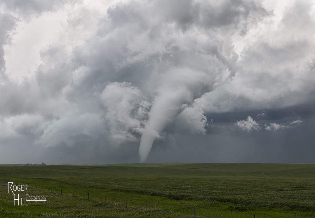
Photos
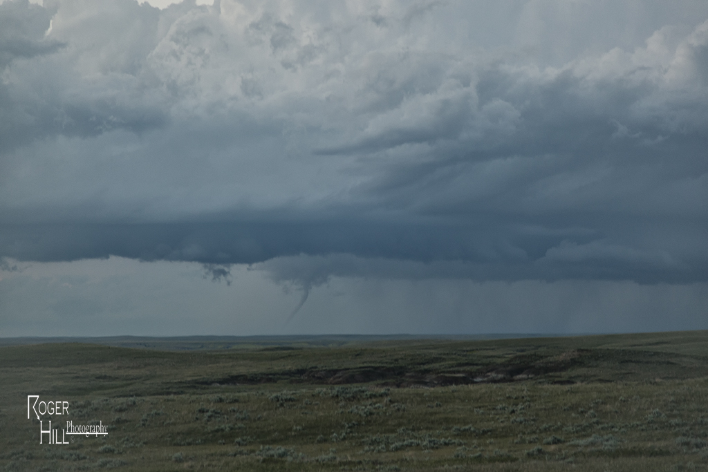
All photos below were provided courtesy of Roger Hill.
 |
 |
 |
 |
| Tornado #1 looking east-southeast from about 6 miles east of Ralph, SD | Tornado #5 looking north-northeast from about 5 miles south-southwest of Meadow, SD | Tornado #6 looking north-northeast from near Faith, SD at 8:50 pm MDT (about 20 miles away from the tornado) | Supercell thunderstorm looking north-northeast from near Faith, SD at 8:52 pm MDT |
Radar
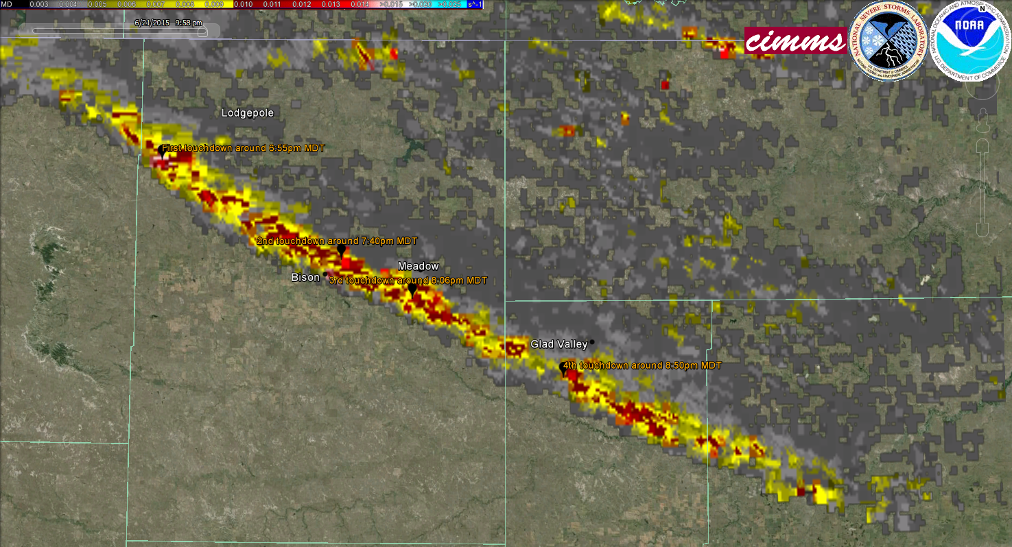 |
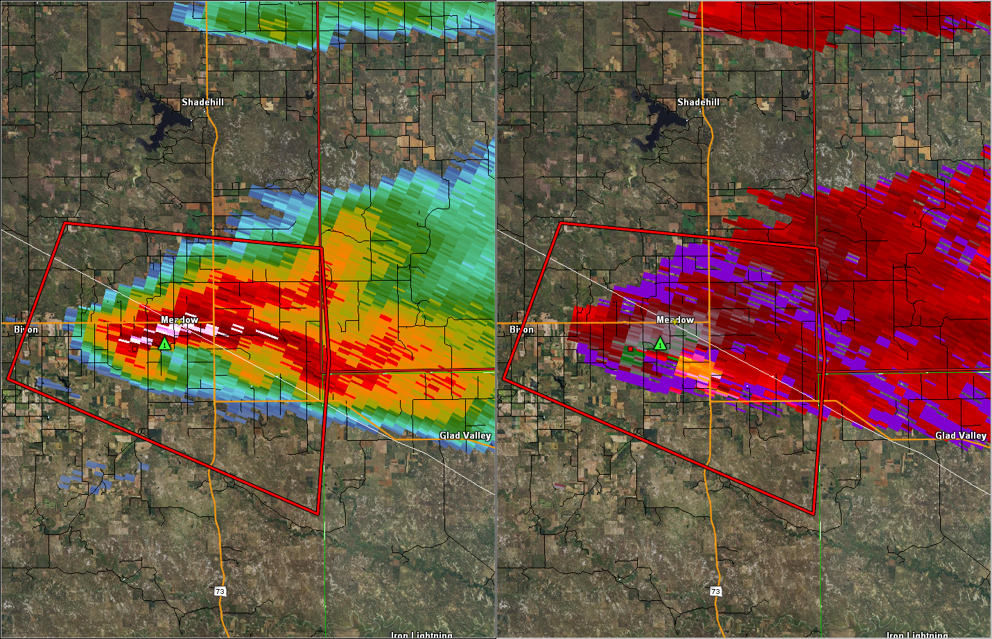 |
| Tornado track as approximated by Doppler radar derived rotation | Radar reflectivity (left) and velocity (right) of the tornado near Meadow at 8:03 pm MDT |
Storm Reports
PRELIMINARY LOCAL STORM REPORT...SUMMARY
NATIONAL WEATHER SERVICE RAPID CITY SD
1001 AM MDT TUE JUN 23 2015

..TIME...   ...EVENT...      ...CITY LOCATION...     ...LAT.LON...
..DATE...   ....MAG....      ..COUNTY LOCATION..ST.. ...SOURCE....
            ..REMARKS..

0656 PM     TORNADO          10 SW LODGEPOLE         45.71N 102.81W
06/21/2015                   PERKINS            SD   TRAINED SPOTTER

            ROPED OUT AND LIFTED AROUND 720PM JUST EAST OF HIGHWAY
            75 AND NORTH OF HIGHWAY 20.

0700 PM     FUNNEL CLOUD     7 SW LODGEPOLE          45.75N 102.78W
06/21/2015                   PERKINS            SD   TRAINED SPOTTER

0740 PM     TORNADO          3 ENE BISON             45.54N 102.40W
06/21/2015                   PERKINS            SD   TRAINED SPOTTER

            LARGE BOWL SHAPED TORNADO TOUCHED DOWN FOR ABOUT TEN
            MINUTES

0806 PM     TORNADO          4 SW MEADOW             45.49N 102.27W
06/21/2015                   PERKINS            SD   TRAINED SPOTTER

            ELEPHANT TRUNK TORNADO ON GROUND FOR AROUND 5 MINUTES.

0850 PM     TORNADO          7 WSW GLAD VALLEY       45.36N 101.92W
06/21/2015                   ZIEBACH            SD   TRAINED SPOTTER

            SLENDER ROPE ON THE GROUND FOR ABOUT 2 MINUTES.

THE STORM REPORTS LISTED BELOW ARE IN DESCENDING ORDER AND MAY NOT NECESSARILY
BE THE FINAL STORM REPORTS.

HAIL REPORTS LISTED BY SIZE (INCHES)

 SIZE    LOCATION                 ST  COUNTY           TIME
------  -----------------------  --  --------------   -------
  2.75   7 SE MEADOW              SD  PERKINS          0815 PM
                 LASTED 15 MINUTES
  2.00   8 ESE MEADOW             SD  PERKINS          0813 PM
  2.00   6 S LODGEPOLE            SD  PERKINS          0707 PM
                 FOUND NUMEROUS GOLF BALL SIZE HAIL STONES IN
                 YARD 30 MINUTES AFTER THE STORM PASSED
                 THROUGH.
  1.75   4 NW MEADOW              SD  PERKINS          0740 PM
  1.50   9 NNE ALVA               WY  CROOK            1100 PM
  1.00   9 NE LADNER              SD  HARDING          0620 PM
                 LASTED 5 MINUTES

TSTM WIND REPORTS LISTED BY SPEED (MPH)

 SPEED   LOCATION                 ST  COUNTY           TIME
------  -----------------------  --  --------------   -------
70.00   8 N HAMILL               SD  TRIPP            0145 AM
70.00   8 ENE BELVIDERE          SD  JACKSON          0145 AM
70.00   9 NNW CREIGHTON          SD  PENNINGTON       1235 AM
                 LARGE TREES BLOWN DOWN...SMALL HAIL LASTED 15
                 MIN
62.00   2 ENE COTTONWOOD         SD  JACKSON          0110 AM
61.00   2 ENE SHERIDAN LAKE      SD  PENNINGTON       1210 AM
                 TIME ESTIMATED FROM RADAR
60.00   11 NNE WOOD              SD  MELLETTE         0225 AM
60.00   6 NE OTTUMWA             SD  HAAKON           0115 AM
60.00   7 N BELVIDERE            SD  JACKSON          1230 AM
60.00   3 SE DOWNTOWN SPEARFISH  SD  LAWRENCE         1130 PM
                 3 DIAMETER TREE LIMBS KNOCKED OFF TREES
60.00   6 W ALADDIN              WY  CROOK            1115 PM
                 LIVE TREE LIMBS OF 1 TO 3 IN DIAMETER RIPPED
                 OFF TREES FROM WIND
60.00   13 W LODGEPOLE           SD  PERKINS          0655 PM
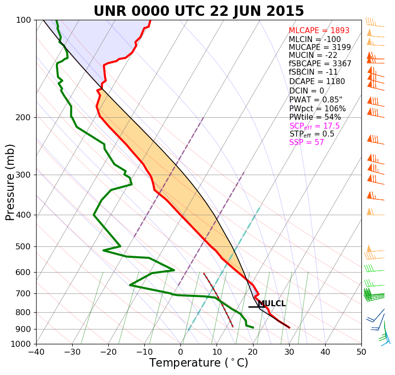
Environment
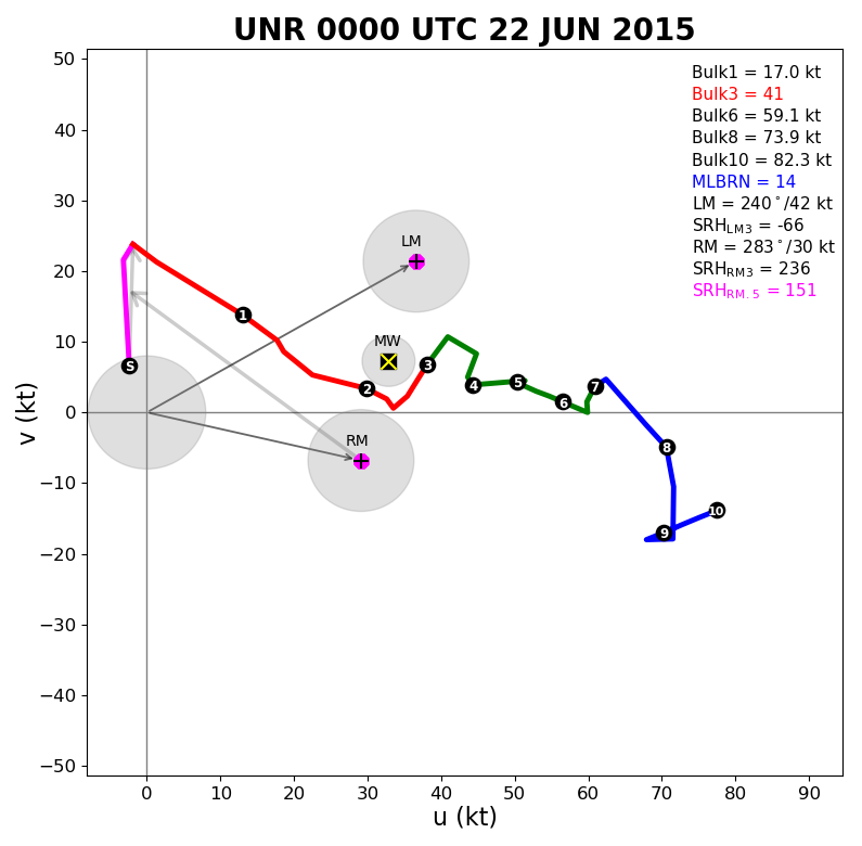
NWS Rapid City balloon information showed a very unstable air mass with strong vertical wind shear. The surface map showed dewpoints in the mid 60s feeding into the area.
 |
 |
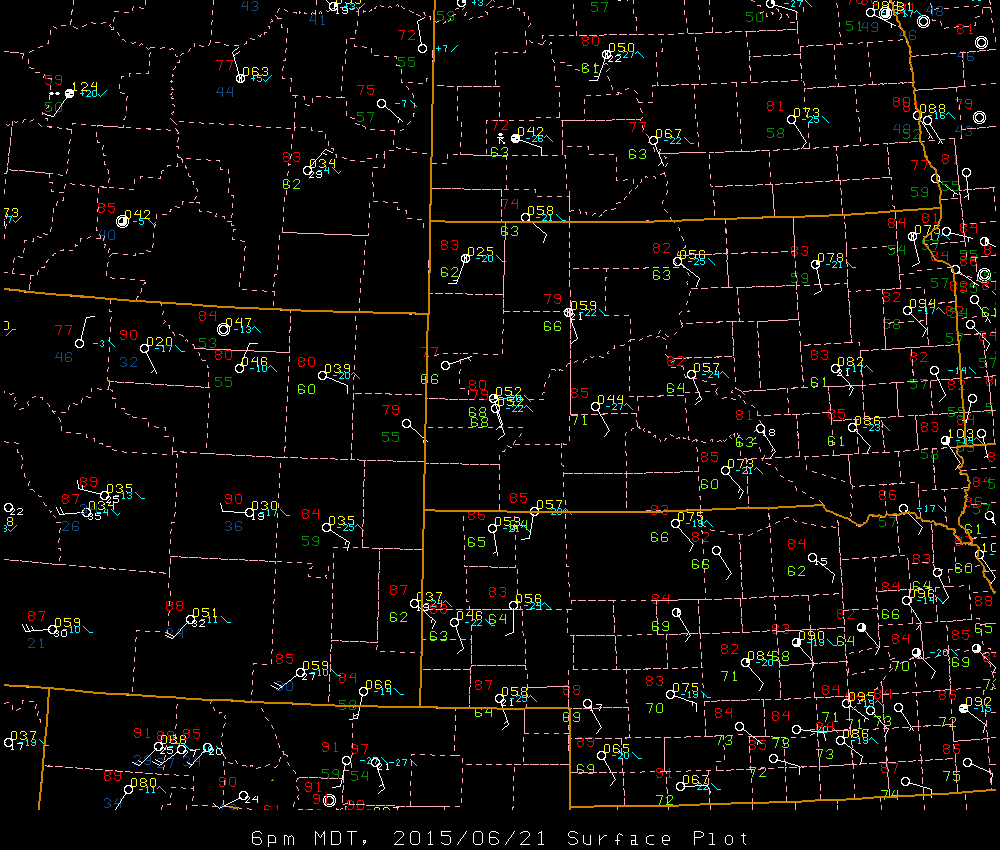 |
| Sounding for Rapid City at 6 pm MDT 21 June 2015 (00z the 22nd) | Hodograph for Rapid City at 6 pm MDT 21 June 2015 (00z the 22nd) | Surface map valid 6 pm MDT 21 June 2015 |
 |
Media use of NWS Web News Stories is encouraged! Please acknowledge the NWS as the source of any news information accessed from this site. |
|

