Tropical Depression Two is expected to gradually strengthen and could bring tropical storm conditions to the Florida Panhandle beginning late Monday. Areas of flash flooding will be possible through Thursday along the eastern and central Gulf Coast. Severe thunderstorms will develop and move along a cold front crossing the Upper Midwest Monday, and through the Ohio Valley/Mid-Atlantic on Tuesday. Read More >
Overview
|
Severe thunderstorms brought large hail, strong winds, and a tornado to western South Dakota on June 19, 2015. Parts of the area were damaged by wind-driven hail, which killed livestock, especially around the Nisland area. Hail around the size of softballs and winds around 100 mph were reported. That storm later produced a relatively long track tornado in southern Meade County, and caused straight-line wind damage to the east-southeast—continuing across central South Dakota. |
|
Tornado:
|
Tornado - Hereford, SD
Track Map 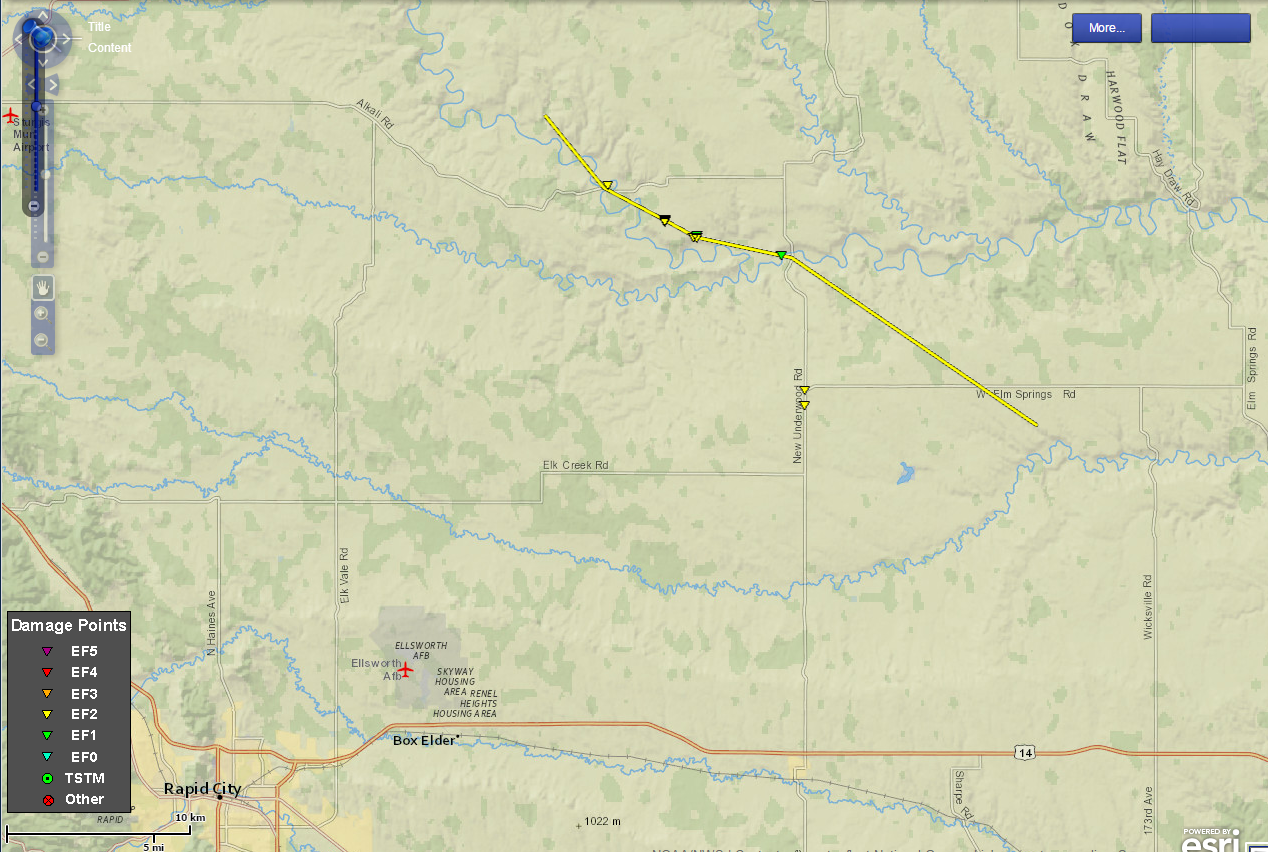  |
||||||||||||||||
The Enhanced Fujita (EF) Scale classifies tornadoes into the following categories:
| EF0 Weak 65-85 mph |
EF1 Moderate 86-110 mph |
EF2 Significant 111-135 mph |
EF3 Severe 136-165 mph |
EF4 Extreme 166-200 mph |
EF5 Catastrophic 200+ mph |
 |
|||||
Photos
Storm, Hail, and Damage Photos
 |
 |
| Supercell near Belle Fourche, SD, as it crossed Highway 212 (photo by Cody Lere) |
Hail damage near Nisland, SD (photo by Natalie Lawrence Johnson) |
 |
 |
| Softball-sized hail near Nisland, SD, around 815 pm (photo by Natalie Lawrence Johnson) |
Hail damage near Nisland, SD (photo by Natalie Lawrence Johnson) |
Radar
Radar Imagery of the Tornadic Storm near Hereford, SD, at 903 pm MDT
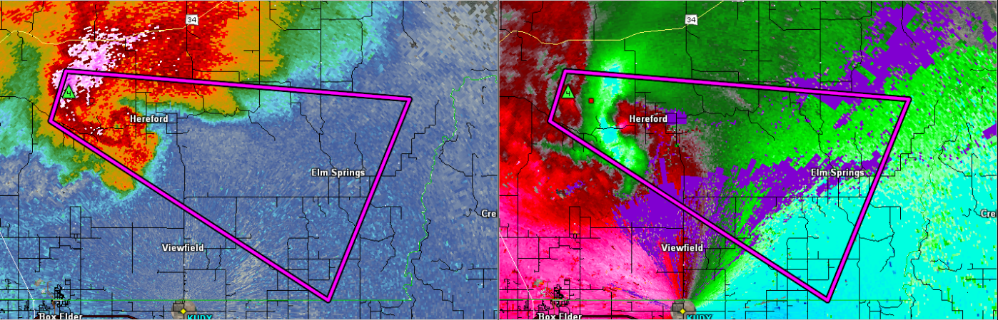 |
| Reflectivity (storm intensity) on the left; storm-relative motion (Doppler winds) on the right |
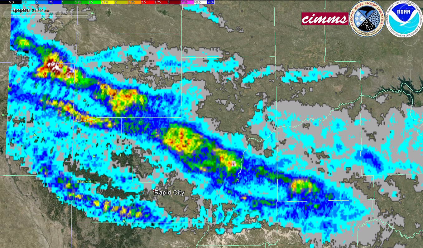 |
| Radar-estimated swaths of maximum hail size on 19 June 2015 (yellow is golf ball size; red is baseball size) |
Storm Reports
THE STORM REPORTS LISTED BELOW ARE IN DESCENDING ORDER AND MAY NOT NECESSARILY
BE THE FINAL STORM REPORTS.

A SIGNIFICANT SEVERE WEATHER EVENT AFFECTED THE AREA ON JUNE 19.
HAIL UP TO 6 INCHES IN DIAMETER...WINDS IN EXCESS OF 100 MPH AND
AN EF2 TORNADO OCCURRED.

HAIL REPORTS LISTED BY SIZE (INCHES)

 SIZE    LOCATION                 ST  COUNTY           TIME
------  -----------------------  --  --------------   -------
  6.00   3 ESE NISLAND            SD  BUTTE            0820 PM
                 LARGEST HAIL STONE MEASURED...SOME MELTING
                 OCCURED BEFORE MEASURMENT...WINDS ESTIMATED
                 AT 70 MPH...TIME ESTIMATED FROM RADAR
  4.50   2 NNW SAINT ONGE         SD  LAWRENCE         0825 PM
  4.50   4 SW NEWELL              SD  BUTTE            0820 PM
                 MULTIPLE WINDOWS BROKEN IN HOUSE
  4.50   NISLAND                  SD  BUTTE            0810 PM
                 SEVERE DAMAGE IN NISLAND AREA. ONE RANCHER
                 LOST 35 HEAD OF SHEEP. MANY PEOPLE HAVE
                 SEVERE PROPERTY DAMAGE... INCLUDING BROKEN
                 WINDOWS... HOLES IN ROOFS OF HOUSES...
                 BARNS... AND OUTBUILDINGS. SEVERAL RANCHERS
                 HAVE LOST LIVESTOCK. MOST VEHICLES LEFT
                 OUTSIDE HAVE BODY DAMAGE AND BROKEN WINDOWS.
  3.00   6 N DOWNTOWN SPEARFISH   SD  LAWRENCE         0830 PM
  2.75   3 S DEERFIELD RESERVOIR  SD  PENNINGTON       1003 PM
                 MULTIPLE CAR WINDOWS BROKEN
  2.75   2 SW VALE                SD  MEADE            0830 PM
  2.50   2 W NISLAND              SD  BUTTE            0830 PM
                 COMBINED WITH WIND GUSTS OF 60-70MPH... 5
                 WINDOWS WERE BROKEN
  2.25   1 E HERMOSA              SD  CUSTER           1048 PM
                 REPORT VIA TWITTER
  2.00   HILL CITY                SD  PENNINGTON       1020 PM
                 REPORT VIA TWITTER
  1.75   KEYSTONE                 SD  PENNINGTON       1030 PM
                 REPORT VIA TWITTER
  1.75   6 ENE BELLE FOURCHE RES  SD  BUTTE            0813 PM
                 BROKEN WINDOWS
  1.75   2 SE COLONY              WY  CROOK            0710 PM
  1.00   2 W HAYWARD              SD  PENNINGTON       1030 PM
                 MOSTLY PEA SIZE WITH A FEW QUARTER SIZE HAIL
  1.00   1 SSE DEERFIELD RESERVO  SD  PENNINGTON       1000 PM
  1.00   SUNDANCE                 WY  CROOK            0910 PM
                 ONLY A FEW HAIL STONES... MOSTLY NICKEL SIZE
                 WITH A FEW QUARTERS
  1.00   6 NNW HEREFORD           SD  MEADE            0910 PM
  1.00   6 ENE BELLE FOURCHE RES  SD  BUTTE            0808 PM
  1.00   PINE HAVEN               WY  CROOK            0627 PM
  0.75   WALL                     SD  PENNINGTON       1032 PM
                 REPORT VIA SPOTTER NETWORK

TSTM WIND REPORTS LISTED BY SPEED (MPH)

 SPEED   LOCATION                 ST  COUNTY           TIME
------  -----------------------  --  --------------   -------
100.00   4 SSW HEREFORD           SD  MEADE            0903 PM
                 THUNDERSTORM REAR FLANK DOWNDRAFT WINDS
                 ESTIMATED AT OVER 100 MPH PRODUCED
                 SIGNIFICANT UTILITY POLE DAMAGE
89.00   13 NW DOWNTOWN BELLE FO  SD  BUTTE            0730 PM
81.00   3 E WICKSVILLE           SD  PENNINGTON       1010 PM
73.00   8 S WALL                 SD  PENNINGTON       1024 PM
                 TIME ESTIMATED FROM RADAR
70.00   3 ESE NISLAND            SD  BUTTE            0920 PM
70.00   4 SW NEWELL              SD  BUTTE            0820 PM
                 MULTIPLE WINDOWS BROKEN IN HOUSE
70.00   2 SE COLONY              WY  CROOK            0710 PM
69.00   3 NNW SCENIC             SD  PENNINGTON       1010 PM
68.00   1 NW NISLAND             SD  BUTTE            0820 PM
67.00   2 SW BRIDGER             SD  ZIEBACH          1010 PM
65.00   2 W NISLAND              SD  BUTTE            0830 PM
                 ESTIMATED 60-70 MPH WINDS. NEIGHBOR LOST ROOF
                 OF BARN.
60.00   6 NNW HEREFORD           SD  MEADE            0910 PM
60.00   8 E WESTON               WY  CAMPBELL         0825 PM
60.00   1 WNW HULETT             WY  CROOK            0740 PM
                 SOME NICKEL SIZE HAIL
55.00   2 E COTTONWOOD           SD  JACKSON          1045 PM
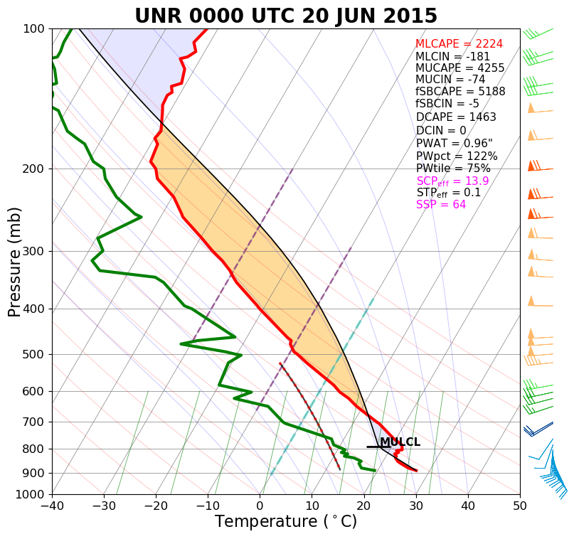
Environment
NWS Rapid City balloon information showed a very unstable air mass with strong vertical wind shear. The three surface maps (bottom row) show a very moist (dewpoints in the mid 60s to lower 70s) south to southeast flow into west-central South Dakota.
 |
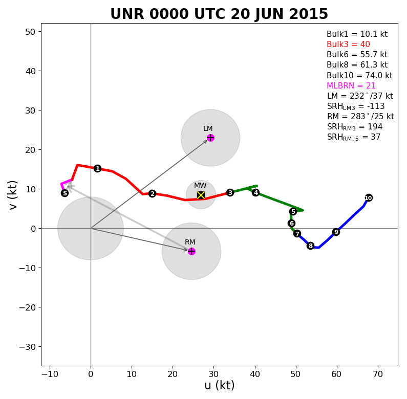 |
| Sounding for Rapid City at 6 pm MDT 19 June 2015 (00z the 20th) | Hodograph for Rapid City at 6 pm MDT 19 June 2015 (00z the 20th) |
 |
 |
 |
| Surface map valid 3 pm MDT 19 June 2015 | Surface map valid 3 pm MDT 19 June 2015 | Surface map valid 9 pm MDT 19 June 2015 |
 |
Media use of NWS Web News Stories is encouraged! Please acknowledge the NWS as the source of any news information accessed from this site. |
|