
Heavy rainfall capable of causing flash flooding will continue to impact Hawaii through Monday. Severe thunderstorms and heavy rain are possible in parts of Texas and the southern Plains and the Upper Great Lakes. Heavy mountain snow continues in California's Sierra Nevada and rain with gusty winds to lower elevations. Super Typhoon Sinlaku will impact the Marianas through midweek. Read More >
Overview
Two days of severe weather affected northeastern Wyoming and western South Dakota on June 1–2, 2015. Large hail, damaging winds, and flooding were reported. Both storms were captured on time-lapse video by off-duty NWS employees. Pictures of the flooding aftermath and giant hail are included.
Photos & Video
Storm from June 1, 2015
| Time-lapse video taken by Dan McKemy (off-duty NWS employee) near Black Hawk, SD, on June 1, 2015 | Time-lapse video taken by Aaron Ward (off-duty NWS employee) near Rapid City, SD, on June 1, 2015 |
 |
| Hail near Piedmont, SD, around 7 pm MDT June 1, 2015 (photo by off-duty NWS employee Alex Calderon) |
These photos were taken during the early morning of June 2, 2015 by off-duty NWS employee Alex Calderon.
 |
 |
 |
Storm from June 2, 2015
A series of severe thunderstorms affected northeastern Wyoming and western South Dakota between 4 pm June 2, 2015 and the early morning of June 3, 2015. Up to golf ball size hail was reported along with wind gusts up to 70 mph. The time-lapse of the storm below was the one that produced golf ball size hail around 4:30 pm MDT 4 miles northeast of Rockerville, SD. The video is indicative of a low precipitation (LP) supercell during the initial stages of the thunderstorm.
| Time-lapse video taken by Dan McKemy (off-duty NWS employee) near Rapid City, SD, on June 2, 2015 |
Radar
June 1, 2015
A severe thunderstorm developed between Sturgis and Rapid City, SD, around 5:10 pm MDT on June 1, 2015. The storm moved very slowly to the south producing hail up to softball size in Piedmont, SD, around 6:55 pm. The storm weakened by 9 pm, but flooding continued overnight. Here are two radar images from 6:38 pm MDT when the storm was very intense.
|
|
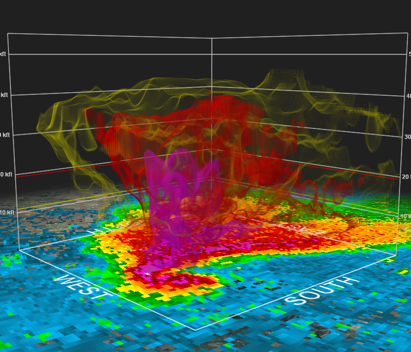 |
| June 1, 2015 6:37 pm MDT 0.5 base reflectivity image | June 1, 2015 6:37 pm MDT 0.5 3-dimensional view of supercell |
Storm Reports
Storms Reports for June 1, 2015
THE STORM REPORTS LISTED BELOW ARE IN DESCENDING ORDER AND MAY NOT NECESSARILY
BE THE FINAL STORM REPORTS.

HAIL REPORTS LISTED BY SIZE (INCHES)

 SIZE    LOCATION                 ST  COUNTY           TIME
 ------  -----------------------  --  --------------   -------
  4.50   PIEDMONT                 SD  MEADE            0655 PM
  2.50   1 NW PIEDMONT            SD  MEADE            0712 PM
  2.50   PIEDMONT                 SD  MEADE            0655 PM
                 MILE MARKER 44 ON I90
  2.00   1 NW PIEDMONT            SD  MEADE            0620 PM
  1.75   1 ESE PIEDMONT           SD  MEADE            0735 PM
  1.75   BLACK HAWK               SD  MEADE            0717 PM
  1.75   PIEDMONT                 SD  MEADE            0655 PM
  1.75   2 S TILFORD              SD  MEADE            0520 PM
  1.50   1 NW PIEDMONT            SD  MEADE            0613 PM
  1.25   1 NW PIEDMONT            SD  MEADE            0550 PM
  1.25   TILFORD                  SD  MEADE            0510 PM
  1.00   7 E CREIGHTON            SD  PENNINGTON       0943 PM
  1.00   3 N DOWNTOWN BELLE FOUR  SD  BUTTE            0922 PM
  1.00   PIEDMONT                 SD  MEADE            0626 PM
                 EXIT 44 AND I-90 LOTS OF HAIL
  1.00   PIEDMONT                 SD  MEADE            0619 PM
                 HEAVY RAIN... SOME STREETS OVERFLOWING WATER
                 PONDING INTO GRASSY AREAS
  0.88   11 NW DOWNTOWN RAPID CI  SD  MEADE            0816 PM
                 OVER AN INCH OF RAIN
  0.25   1 NW PIEDMONT            SD  MEADE            0550 PM

TSTM WIND REPORTS LISTED BY SPEED (MPH)

 SPEED   LOCATION                 ST  COUNTY           TIME
 ------  -----------------------  --  --------------   -------
 65.00   2 NNW SAINT ONGE         SD  LAWRENCE         1000 PM
 60.00   9 N BOX ELDER            SD  MEADE            0800 PM
Storms Reports for June 2, 2015
THE STORM REPORTS LISTED BELOW ARE IN DESCENDING ORDER AND MAY NOT NECESSARILY
BE THE FINAL STORM REPORTS.

HAIL REPORTS LISTED BY SIZE (INCHES)

 SIZE    LOCATION                 ST  COUNTY           TIME
 ------  -----------------------  --  --------------   -------
  1.75   3 N ROCKERVILLE          SD  PENNINGTON       0432 PM
  1.75   4 NE ROCKERVILLE         SD  PENNINGTON       0430 PM
  1.25   4 NE ROCKERVILLE         SD  PENNINGTON       0430 PM
  1.00   4 S DOWNTOWN RAPID CITY  SD  PENNINGTON       0436 PM
  0.88   ROCKERVILLE              SD  PENNINGTON       0620 PM
  0.88   ROCKERVILLE              SD  PENNINGTON       0442 PM
  0.75   3 N SHERIDAN LAKE        SD  PENNINGTON       0415 PM

TSTM WIND REPORTS LISTED BY SPEED (MPH)

 SPEED   LOCATION                 ST  COUNTY           TIME
 ------  -----------------------  --  --------------   -------
 70.00   9 ENE BELVIDERE          SD  JACKSON          1230 AM (JUNE 3, 2015)
 66.00   1 NE MIDLAND             SD  HAAKON           1230 AM (JUNE 3, 2015)
 62.00   10 ESE PINE HAVEN        WY  CROOK            0825 PM
                 62 MPH WIND GUSTS FROM 825 TO 830 PM.
 60.00   3 WNW WASTA              SD  PENNINGTON       1050 PM
 60.00   1 E DOWNTOWN RAPID CITY  SD  PENNINGTON       1008 PM
 60.00   2 ENE WESTON             WY  CAMPBELL         0735 PM
 60.00   1 NW MARTIN              SD  BENNETT          0715 PM
 58.00   6 W PARMELEE             SD  TODD             0800 PM
 58.00   1 ESE MARTIN             SD  BENNETT          0715 PM
 57.00   4 SE SUNDANCE            WY  CROOK            0850 PM
Environment
June 1, 2015
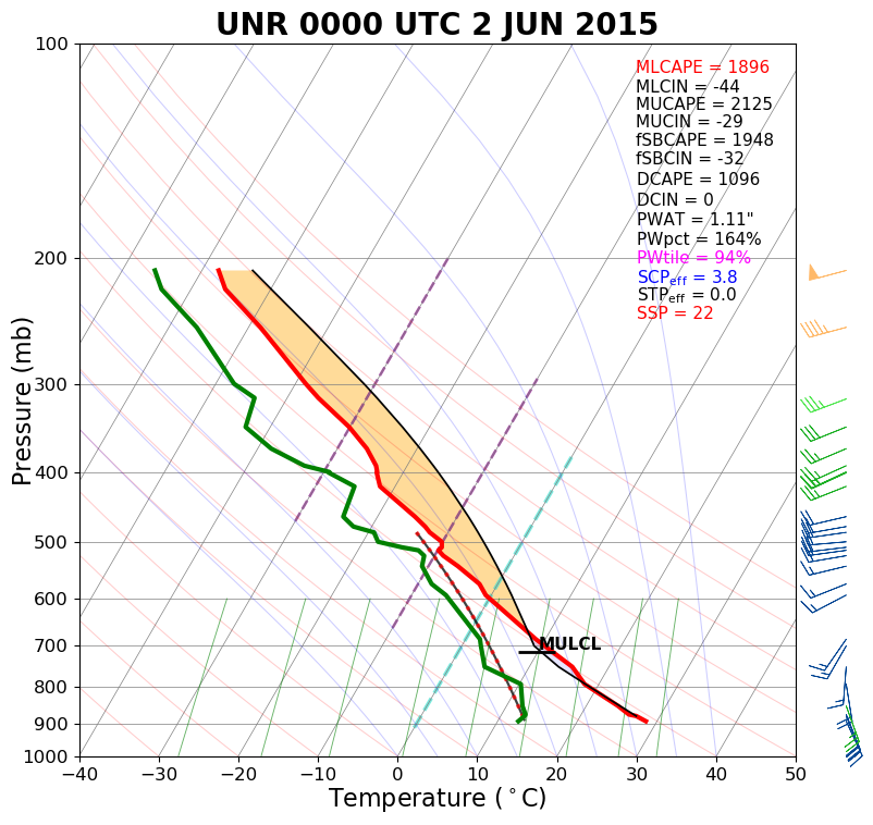
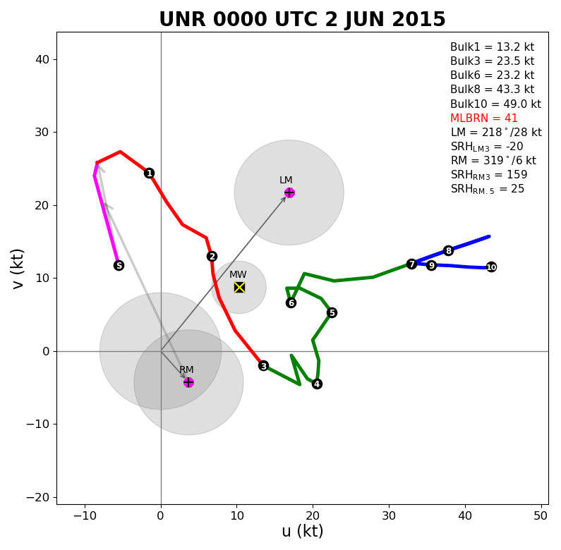
NWS Rapid City balloon information showed a moderately unstable air mass with sufficient vertical wind shear for slow-moving supercells. The surface map showed dewpoints in the lower 60s on the eastern side of the Black Hills.
 |
 |
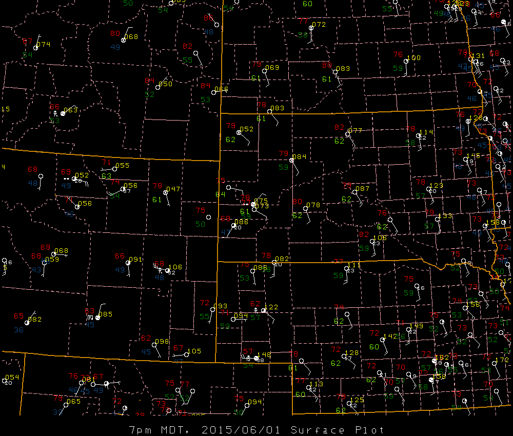 |
| Sounding for Rapid City at 6 pm MDT 1 June 2015 (00z the 2nd) | Hodograph for Rapid City at 6 pm MDT 1 June 2015 (00z the 2nd) | Surface map valid 7 pm MDT 1 June 2015 |
June 2, 2015
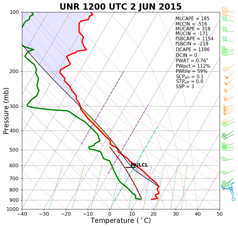
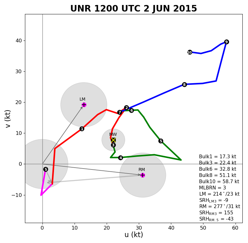
Below is the 6 am balloon information for NWS Rapid City because the afternoon balloon release was not representative. However, this still showed a fairly unstable air mass, and afternoon surface dewpoints were in the upper 50s with a northerly wind. The result on this day was a supercell that formed farther south than the previous day, near Rockerville.
 |
 |
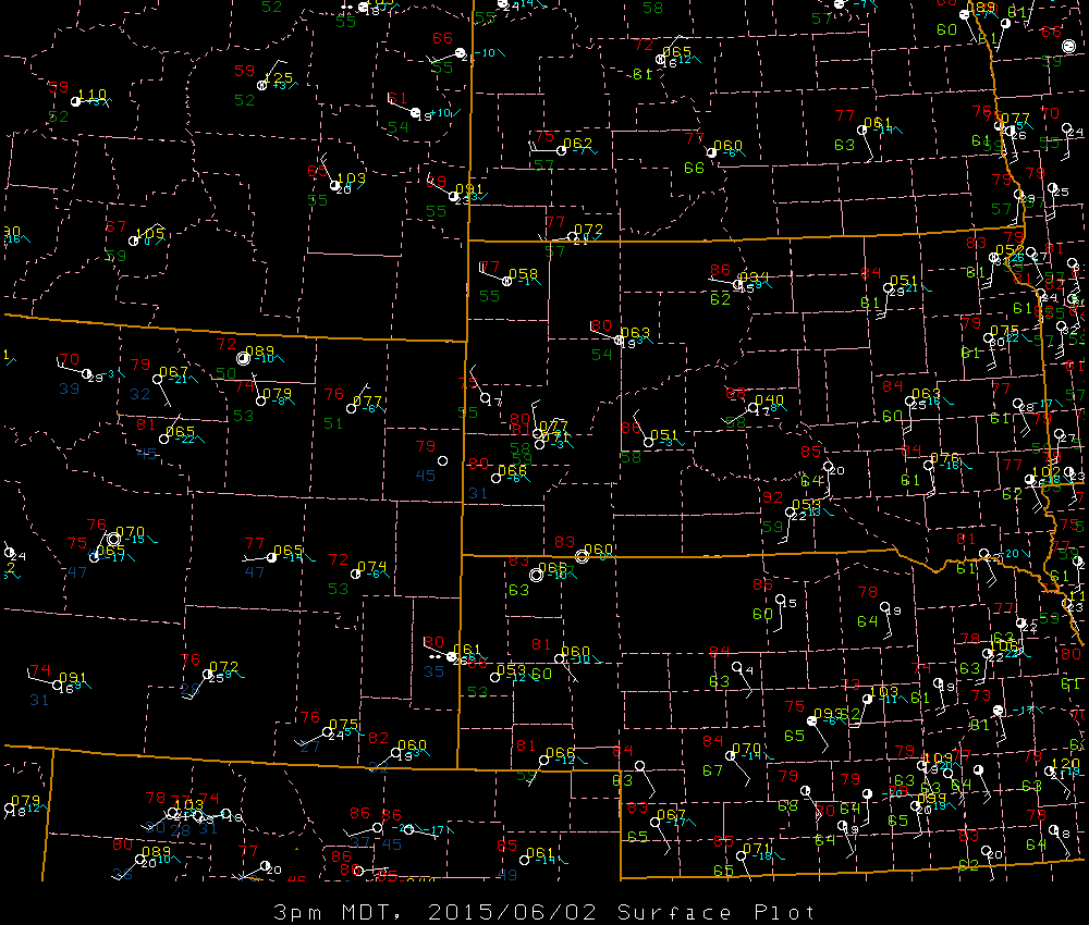 |
| Sounding for Rapid City at 6 am MDT 2 June 2015 | Hodograph for Rapid City at 6 am MDT 2 June 2015 | Surface map valid 3 pm MDT 2 June 2015 |
 |
Media use of NWS Web News Stories is encouraged! Please acknowledge the NWS as the source of any news information accessed from this site. |
 |