
Record setting heat is expected over the next several days from the Intermountain West through the northern Plains. Furthermore, fire weather concerns increase with dry and breezy conditions. Meanwhile, heavy rainfall and severe thunderstorm threats for the Ohio/Tennessee Valleys, central Appalachians and Southeast today. The threat shifts to central Gulf Coast and across central Texas this week. Read More >
Overview
Multiple tornadoes with two separate storms tracked across eastern Meade and Perkins Counties, South Dakota, on Monday afternoon, May 24, 2010. At times, two tornadoes occurred simultaneously. The widest tornado was near a quarter mile wide, and two of the tornadoes traveled at least 20 miles. Significant tornado damage occurred with both storms, resulting in EF-2 damage ratings (estimated wind gusts 111 to 135 mph) by the National Weather Service (NWS) assessment teams.
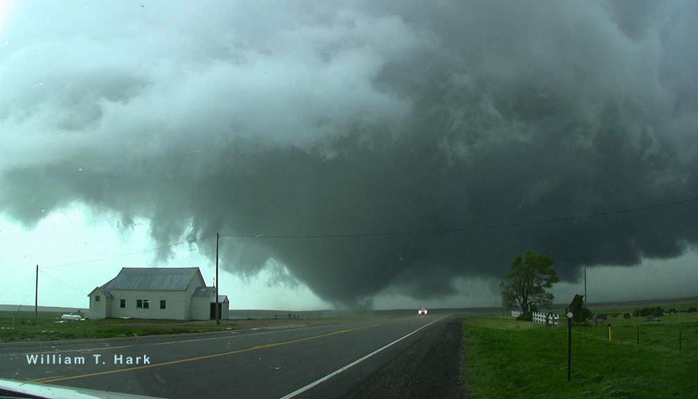 |
| Tornado west of Howes, SD, on 24 May 2010 (courtesy Bill Hark) |
Tornadoes:
|
Tornado - 5 mi Southeast of Plainview to 14 mi Southwest of Faith
Track Map 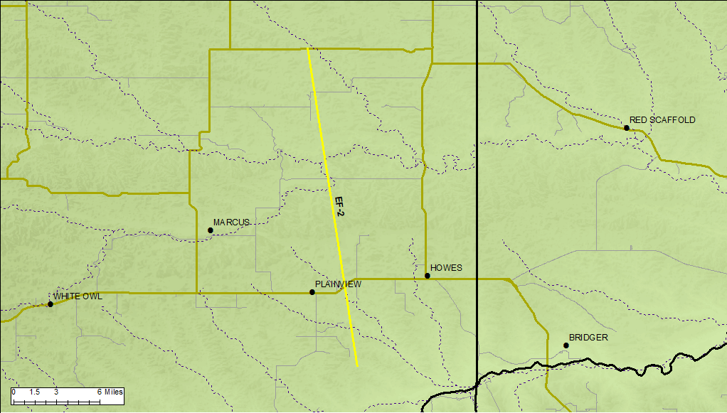  |
||||||||||||||||
|
Tornado - 6 mi Southwest of Faith to 3 mi West of Faith
Track Map 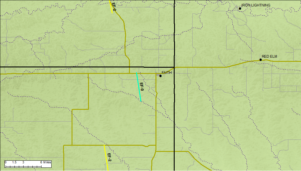 |
||||||||||||||||
|
Tornado - 4 mi South/southeast of Usta to 2 mi South of Meadow
Track Map 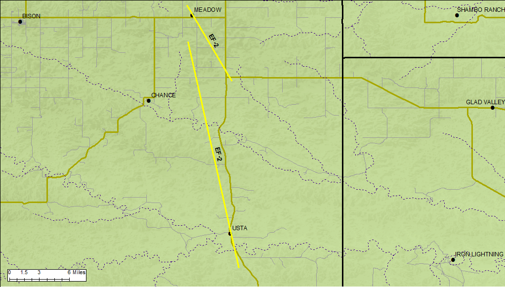 |
||||||||||||||||
|
Tornado - 7 mi Southeast of Meadow to 1 mi North of Meadow
Track Map 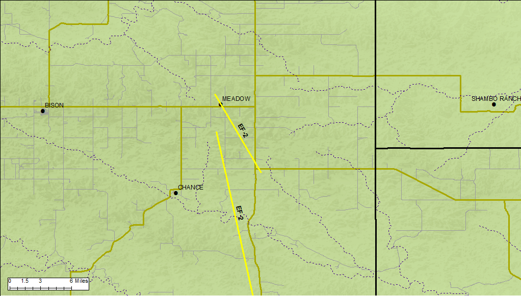 |
||||||||||||||||
|
Tornado - 3 mi West of Shadehill
Track Map 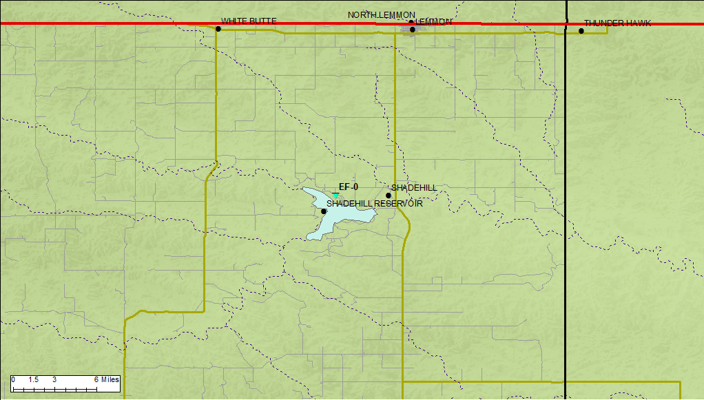 |
||||||||||||||||
The Enhanced Fujita (EF) Scale classifies tornadoes into the following categories:
| EF0 Weak 65-85 mph |
EF1 Moderate 86-110 mph |
EF2 Significant 111-135 mph |
EF3 Severe 136-165 mph |
EF4 Extreme 166-200 mph |
EF5 Catastrophic 200+ mph |
 |
|||||
Photos
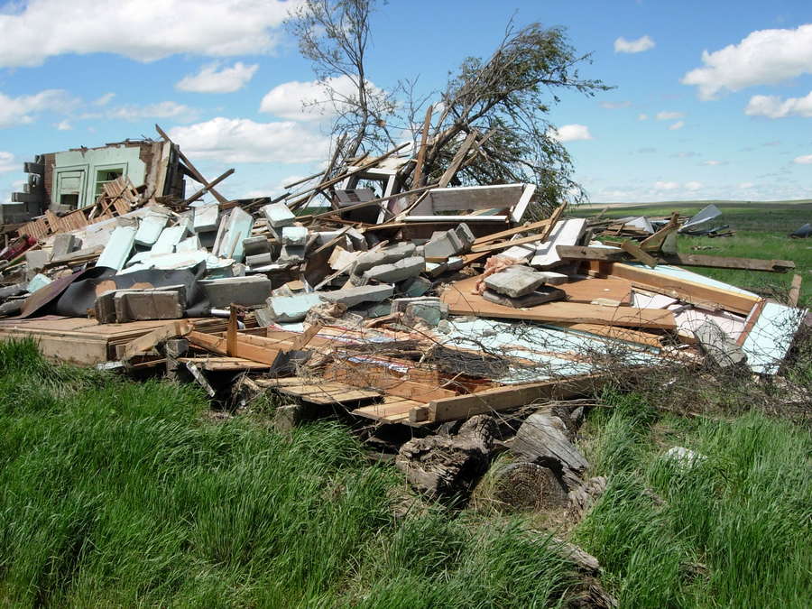
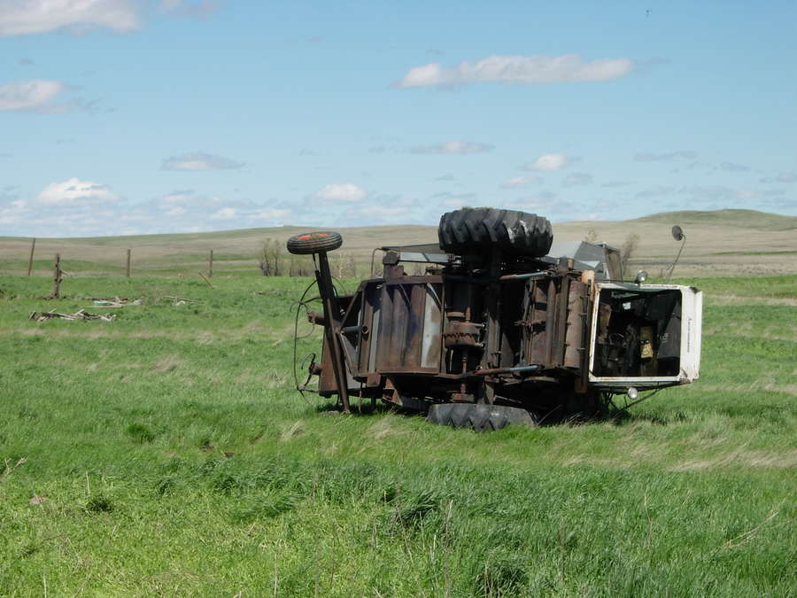
Here are some photos from the two NWS service assessment teams that evaluated the damage on May 25, 2010.
 |
 |
 |
 |
| Damage to manufactured home southwest of Howes (NWS storm survey) |
Damage to uninhabited cinder block home (NWS storm survey) |
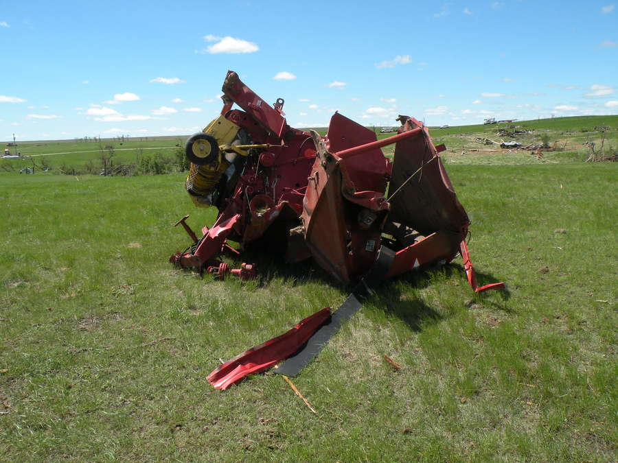
Gleaner combine damaged (NWS storm survey) |
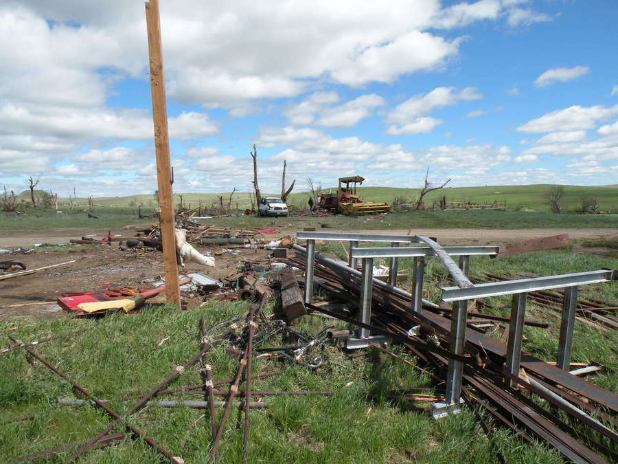
Destruction of pole barn (foreground), with van and hay swather thrown into trees (NWS storm survey) |
 |
 |
 |
 |
| Destroyed round baler thrown about 300 yards from destroyed pole barn (distant, behind baler) (NWS storm survey) |
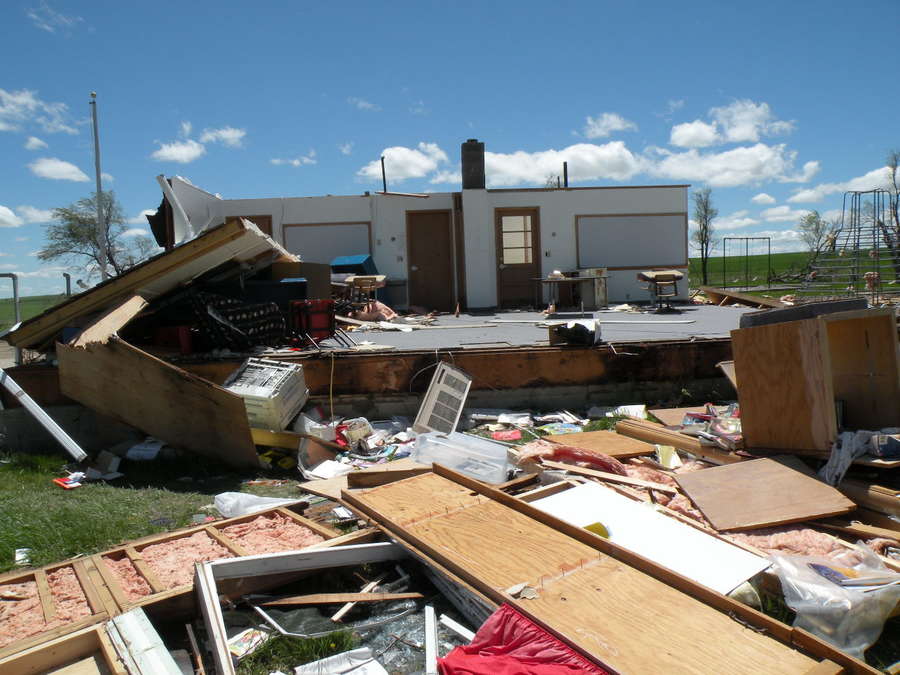
Destruction of Progress School (chimney helped interior walls remain standing) (NWS storm survey) |
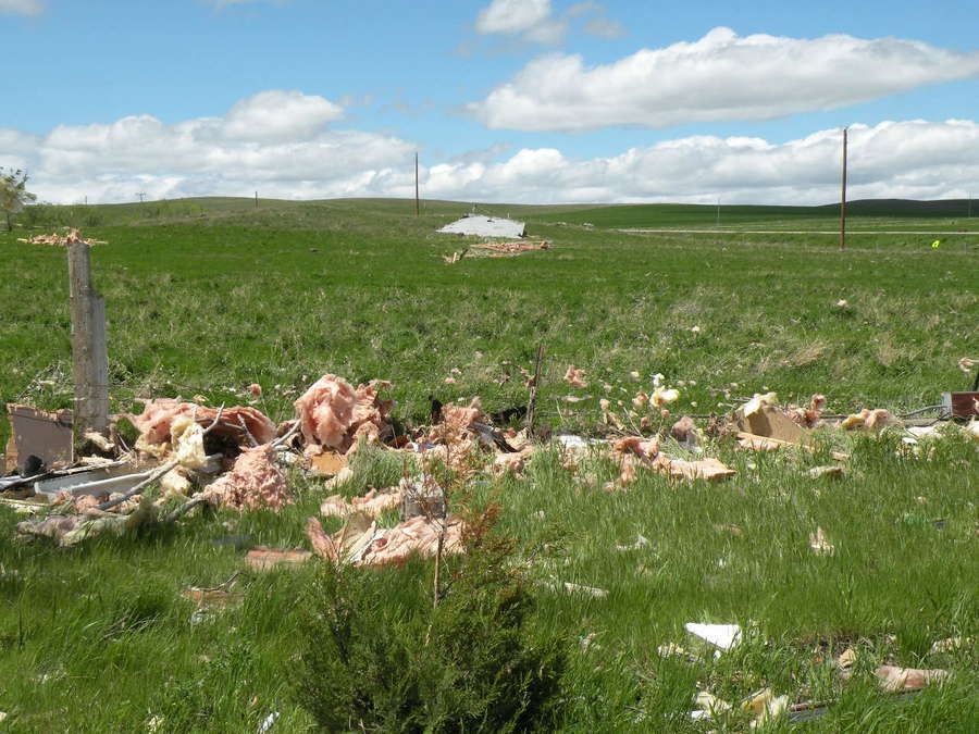
Debris from the roof of Progress School 175 yards to the northwest (NWS storm survey) |
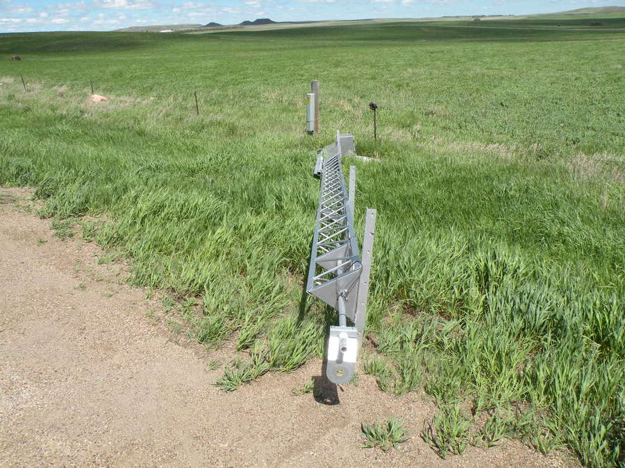
Damage to SD DOT weather sensor near intersection of Highways 20 and 73 (NWS storm survey) |
Radar
Here is a radar animation at 15-min intervals from 11 am to 7 pm on May 24, 2010. The tornadic storm developed in eastern Pennington County and then moved almost due north across eastern Meade and Perkins Counties, producing at five tornadoes along its path. Later, a line of severe storms moved through much of western South Dakota (see storm reports section). Finally, toward the end of the animation some light rain and even some snow began to move into the Black Hills area.
| NWS Rapid City radar animation from 11 am to 7 pm on May 24, 2010 |
Storm Reports
Below is a map of preliminary storm reports for western South Dakota and surrounding areas, followed by a list of storm reports for the NWS Rapid City area of responsibility.
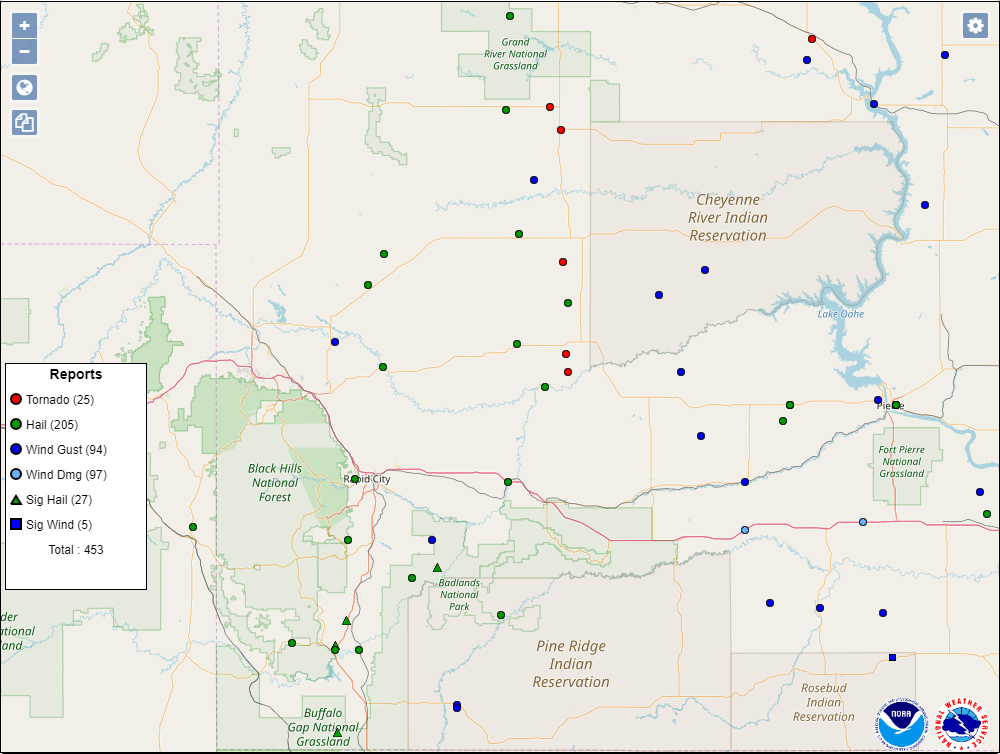 |
| Storm reports for May 24, 2010 |
PRELIMINARY LOCAL STORM REPORT...SUMMARY
NATIONAL WEATHER SERVICE RAPID CITY SD
837 PM MDT MON MAY 24 2010

..TIME...   ...EVENT...      ...CITY LOCATION...     ...LAT.LON...
..DATE...   ....MAG....      ..COUNTY LOCATION..ST.. ...SOURCE....
            ..REMARKS..

1215 PM     HAIL             11 SW OELRICHS          43.07N 103.39W
05/24/2010  E2.75 INCH       FALL RIVER         SD   PUBLIC

            BASEBALL SIZE HAIL SMASHED VEHICLE WINDOWS.

1236 PM     HAIL             19 ESE HERMOSA          43.73N 102.84W
05/24/2010  E2.00 INCH       CUSTER             SD   TRAINED SPOTTER

1250 PM     HAIL             1 N MAVERICK JUNCTION   43.42N 103.40W
05/24/2010  E4.25 INCH       FALL RIVER         SD   BROADCAST MEDIA

1250 PM     HAIL             MAVERICK JUNCTION       43.40N 103.40W
05/24/2010  E1.75 INCH       FALL RIVER         SD   TRAINED SPOTTER

0100 PM     HAIL             2 NW BUFFALO GAP        43.52N 103.34W
05/24/2010  E4.00 INCH       CUSTER             SD   TRAINED SPOTTER

            HAILSTONES FROM 3.5 TO 4 INCHES IN DIAMETER.

0108 PM     HAIL             12 SSW PLAINVIEW        44.44N 102.25W
05/24/2010  E1.00 INCH       PENNINGTON         SD   TRAINED SPOTTER

0110 PM     HAIL             3 NNE DOWNTOWN NEWCASTL 43.89N 104.18W
05/24/2010  E1.25 INCH       WESTON             WY   TRAINED SPOTTER

0124 PM     TORNADO          9 SSW HOWES             44.50N 102.12W
05/24/2010                   MEADE              SD   TRAINED SPOTTER

            STORM SPOTTER REPORTED A TORNADO NEAR THE INTERSECTION OF
            HIGHWAY 73 AND 34 NEAR THE MEADE COUNTY ZIEBACH COUNTY
            LINE.

0125 PM     HAIL             3 W DOWNTOWN RAPID CITY 44.08N 103.29W
05/24/2010  E1.50 INCH       PENNINGTON         SD   TRAINED SPOTTER

0125 PM     HAIL             4 W COTTONWOOD SPRINGS  43.43N 103.64W
05/24/2010  E1.00 INCH       FALL RIVER         SD   TRAINED SPOTTER

            QUARTER SIZE HAIL REPORTED FROM 125 PM TO 135 PM.

0128 PM     HAIL             2 S HAYWARD             43.84N 103.33W
05/24/2010  E1.00 INCH       CUSTER             SD   TRAINED SPOTTER

0202 PM     TSTM WND GST     VALE                    44.62N 103.40W
05/24/2010  E60.00 MPH       BUTTE              SD   TRAINED SPOTTER

            TIME ESTIMATED.

0208 PM     TORNADO          8 SW FAITH              44.93N 102.15W
05/24/2010                   MEADE              SD   TRAINED SPOTTER

            LARGE TORNADO 8 MILES SOUTHWEST OF FAITH.

0232 PM     HAIL             13 NE NEWELL            44.84N 103.22W
05/24/2010  E1.25 INCH       BUTTE              SD   TRAINED SPOTTER

0235 PM     HAIL             ORAL                    43.40N 103.27W
05/24/2010  E1.25 INCH       FALL RIVER         SD   TRAINED SPOTTER

0238 PM     HAIL             12 SSE HOOVER           44.96N 103.13W
05/24/2010  E1.00 INCH       BUTTE              SD   TRAINED SPOTTER

            VERY HEAVY RAIN ALONG WITH QUARTER SIZE HAIL.

0239 PM     HAIL             10 E MAURINE            45.04N 102.39W
05/24/2010  E1.00 INCH       MEADE              SD   TRAINED SPOTTER

0245 PM     TSTM WND GST     8 WNW USTA              45.25N 102.31W
05/24/2010  E70.00 MPH       PERKINS            SD   TRAINED SPOTTER

0246 PM     HAIL             15 SE HERMOSA           43.69N 102.98W
05/24/2010  E1.00 INCH       CUSTER             SD   TRAINED SPOTTER

            TIME ESTIMATED.

0250 PM     HEAVY RAIN       2 N BLACK HAWK          44.18N 103.32W
05/24/2010  M2.10 INCH       MEADE              SD   TRAINED SPOTTER

            WATER OVER SECONDARY ROADS

0308 PM     TORNADO          MEADOW                  45.53N 102.22W
05/24/2010                   PERKINS            SD   LAW ENFORCEMENT

            TORNADO NEAR MEADOWS CORNER AND HIGHWAY 73

0309 PM     FLASH FLOOD      KEYSTONE                43.89N 103.43W
05/24/2010                   PENNINGTON         SD   TRAINED SPOTTER

            WATER IN BASEMENTS

0309 PM     FLASH FLOOD      4 N DOWNTOWN RAPID CITY 44.13N 103.23W
05/24/2010                   PENNINGTON         SD   LAW ENFORCEMENT

            NIKE ROAD IMPASSABLE DUE TO FLOODING

0310 PM     TSTM WND GST     WHITE RIVER             43.57N 100.74W
05/24/2010  E60.00 MPH       MELLETTE           SD   TRAINED SPOTTER

0315 PM     TSTM WND GST     OGLALA                  43.18N 102.73W
05/24/2010  E60.00 MPH       SHANNON            SD   TRAINED SPOTTER

0318 PM     HEAVY RAIN       HISEGA                  44.05N 103.40W
05/24/2010  E1.86 INCH       PENNINGTON         SD   PUBLIC

            SINCE NOON.

0320 PM     FLASH FLOOD      2 W DOWNTOWN RAPID CITY 44.08N 103.27W
05/24/2010                   PENNINGTON         SD   NWS EMPLOYEE

            SIOUX PARK UNDER WATER AT SHERIDAN LAKE ROAD

0325 PM     HAIL             BISON                   45.52N 102.46W
05/24/2010  E1.00 INCH       PERKINS            SD   CO-OP OBSERVER

0335 PM     TSTM WND GST     1 S OGLALA              43.17N 102.73W
05/24/2010  E60.00 MPH       SHANNON            SD   CO-OP OBSERVER

0343 PM     FUNNEL CLOUD     ROCKYFORD               43.50N 102.50W
05/24/2010                   SHANNON            SD   LAW ENFORCEMENT

0345 PM     TSTM WND GST     16 E HERMOSA            43.84N 102.87W
05/24/2010  E65.00 MPH       CUSTER             SD   PUBLIC

            ESTIMATED 60 TO 70 MPH WIND GUST. TIME ESTIMATED.

0347 PM     FLASH FLOOD      4 W HERMOSA             43.84N 103.27W
05/24/2010                   CUSTER             SD   NWS EMPLOYEE

            SEVERAL ROADS ALONG BATTLE CREEK UNDER WATER INCLUDING
            BATTLE CREEK ROAD...CROOKED CANYON ROAD...AND TIFFANY
            LANE.

0356 PM     FLASH FLOOD      DOWNTOWN RAPID CITY     44.08N 103.23W
05/24/2010                   PENNINGTON         SD   NWS EMPLOYEE

            RAPID CREEK OUT OF ITS BANKS FROM FOUNDERS PARK TO
            MOUNTAIN VIEW ROAD.

0402 PM     FLASH FLOOD      4 SE KEYSTONE           43.85N 103.37W
05/24/2010                   CUSTER             SD   TRAINED SPOTTER

            IRON CREEK OUT OF ITS BANKS.

0405 PM     HAIL             3 N ROCKYFORD           43.54N 102.49W
05/24/2010  E1.00 INCH       SHANNON            SD   TRAINED SPOTTER

0418 PM     HAIL             WASTA                   44.07N 102.45W
05/24/2010  E1.75 INCH       PENNINGTON         SD   TRAINED SPOTTER

0435 PM     HAIL             6 SW WHITE BUTTE        45.88N 102.44W
05/24/2010  E1.50 INCH       PERKINS            SD   TRAINED SPOTTER

            PING PONG BALL SIZE HAIL WITH 50 MPH WINDS.

0436 PM     FLASH FLOOD      3 ESE BOX ELDER         44.10N 103.02W
05/24/2010                   PENNINGTON         SD   LAW ENFORCEMENT

            HOUSE AT 229TH EAST OF 156TH IS SURROUNDED BY WATER

0445 PM     FLOOD            4 S BUFFALO GAP         43.43N 103.31W
05/24/2010                   FALL RIVER         SD   EMERGENCY MNGR

            WATER ACROSS BEAVER CREEK ROAD AT BEAVER CREEK.

0449 PM     FLASH FLOOD      3 NE DOWNTOWN RAPID CIT 44.11N 103.19W
05/24/2010                   PENNINGTON         SD   LAW ENFORCEMENT

            INTERSECTINO OF DYESS AVE AND SEGER DRIVE UNDER WATER.

0450 PM     FLASH FLOOD      3 E BOX ELDER           44.12N 103.01W
05/24/2010                   PENNINGTON         SD   LAW ENFORCEMENT

            GREATER THAN SIX INCHES OF WATER OVER 156TH AVE SOUTH OF
            HIGHWAY 1416.

0453 PM     HAIL             2 NE WHITE OWL          44.61N 102.40W
05/24/2010  E1.25 INCH       MEADE              SD   TRAINED SPOTTER

0500 PM     FLASH FLOOD      6 NE DOWNTOWN RAPID CIT 44.14N 103.15W
05/24/2010                   PENNINGTON         SD   EMERGENCY MNGR

            WATER OVER ELK VALE ROAD NORTH OF EXIT 61.

0500 PM     FLASH FLOOD      1 ESE FARMINGDALE       43.96N 102.88W
05/24/2010                   PENNINGTON         SD   LAW ENFORCEMENT

            WATER OVER HIGHWAY 44 AND 160TH AVE.

0500 PM     FLASH FLOOD      15 E DOWNTOWN RAPID CIT 44.07N 102.93W
05/24/2010                   PENNINGTON         SD   EMERGENCY MNGR

            WATER IS OVER 156TH ST AND 159TH ST.

0502 PM     HEAVY RAIN       4 ESE KEYSTONE          43.87N 103.35W
05/24/2010  M2.50 INCH       PENNINGTON         SD   TRAINED SPOTTER

0506 PM     HAIL             10 NE MARCUS            44.77N 102.12W
05/24/2010  E1.00 INCH       MEADE              SD   TRAINED SPOTTER

            HAIL LASTED FROM 506 PM TO 508 PM.

0517 PM     FLASH FLOOD      1 NW RAPID CITY AIRPORT 44.05N 103.07W
05/24/2010                   PENNINGTON         SD   LAW ENFORCEMENT

            LONG VIEW ROAD WASHED OUT.

0522 PM     FLASH FLOOD      3 NNE DOWNTOWN RAPID CI 44.12N 103.21W
05/24/2010                   PENNINGTON         SD   LAW ENFORCEMENT

            WATER OVER INTERSECTION. CAR STUCK IN WATER WITH DRIVER
            BEING RESCUED.

0524 PM     FLASH FLOOD      3 NW BUFFALO GAP        43.52N 103.36W
05/24/2010                   CUSTER             SD   PUBLIC

            WATER OVER THE BANKS ON BEAVER CREEK. CREEK IS ABOUT 50
            YARDS WIDE. 1 MILE WEST OF HIGHWAY 79.

0530 PM     FLASH FLOOD      4 ENE DOWNTOWN RAPID CI 44.10N 103.16W
05/24/2010                   PENNINGTON         SD   LAW ENFORCEMENT

            WATER OVER ELK VALE ROAD A HALF MILE NORTH OF FLYING J
            TRUCK STOP.

0537 PM     TSTM WND GST     1 NE CEDAR BUTTE        43.59N 101.01W
05/24/2010  E60.00 MPH       MELLETTE           SD   TRAINED SPOTTER

0539 PM     TSTM WND GST     MIDLAND                 44.07N 101.15W
05/24/2010  E60.00 MPH       HAAKON             SD   TRAINED SPOTTER

0540 PM     TSTM WND DMG     13 S MIDLAND            43.88N 101.15W
05/24/2010                   JACKSON            SD   PUBLIC

            SEMI TRAILER TIPPED OVER BETWEEN MILE MARKER 165 AND 170
            ON INTERSTATE 90. RELAYED THROUGH PHILIP STATE RADIO.

0545 PM     TSTM WND GST     7 S CHERRY CREEK        44.50N 101.50W
05/24/2010  E65.00 MPH       HAAKON             SD   TRAINED SPOTTER

0545 PM     TSTM WND GST     17 NW MIDLAND           44.25N 101.39W
05/24/2010  E60.00 MPH       HAAKON             SD   TRAINED SPOTTER

0550 PM     TSTM WND GST     2 E OKREEK              43.37N 100.34W
05/24/2010  M82.00 MPH       TODD               SD   TRAINED SPOTTER

0552 PM     FLASH FLOOD      10 N DOWNTOWN RAPID CIT 44.22N 103.23W
05/24/2010                   MEADE              SD   EMERGENCY MNGR

            FLOODING AT HUSKER PLACE.

0556 PM     HEAVY RAIN       10 NE RED OWL           44.80N 102.41W
05/24/2010  M1.50 INCH       MEADE              SD   TRAINED SPOTTER

0605 PM     TSTM WND GST     15 SE DUPREE            44.90N 101.37W
05/24/2010  E60.00 MPH       ZIEBACH            SD   TRAINED SPOTTER

0617 PM     TSTM WND GST     6 NE WOOD               43.55N 100.39W
05/24/2010  E60.00 MPH       MELLETTE           SD   TRAINED SPOTTER

0630 PM     FLASH FLOOD      2 W FARMINGDALE         43.97N 102.94W
05/24/2010                   PENNINGTON         SD   LAW ENFORCEMENT

            WATER OVER HIGHWAY 44 2 MILES WEST OF FARMINGDALE

0650 PM     FLASH FLOOD      9 NNE BOX ELDER         44.24N 103.00W
05/24/2010                   MEADE              SD   PUBLIC

            ANTELOPE CREEK NORTH OF ELK CREEK ROAD IS FLOODED. THIS
            IS A LOW LYING ROAD.
Environment
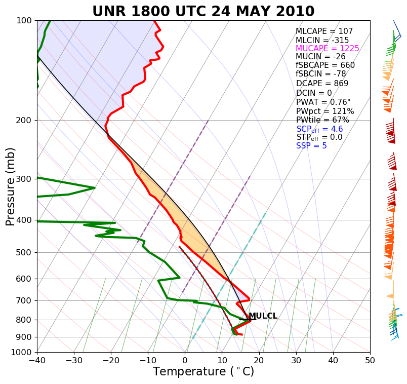
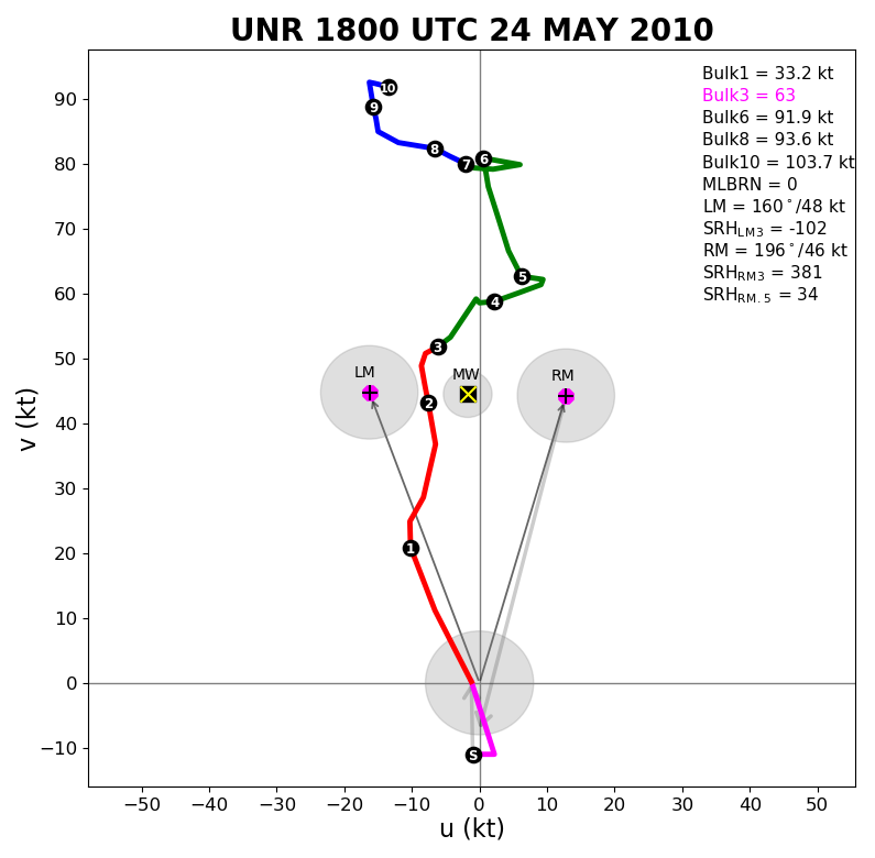
A special NWS Rapid City balloon launch at noon showed a very unstable midlevel air mass, but with cool and cloudy/foggy conditions next to the surface. The vertical wind shear was exceptionally strong and was favorable for supercell thunderstorms and tornadoes. The surface map shows that a cold front (blue line) had moved southeast of Rapid City by 1 pm, while a warm front was located along the eastern fringes of Meade and Perkins Counties. Temperatures (black numbers) were in the loewr 70s along and just to the west of this front, and dewpoint (blue numbers) were in the mid to upper 60s along and east of this warm front. This resulted in an unstable low-level environment over eastern Meade and Perkins Counties. Finally, the winds were blowing from the south throughout much of the atmosphere, which helped steer storms toward the north, right along the warm front, which is a favorable setup for tornadic storms.
 |
 |
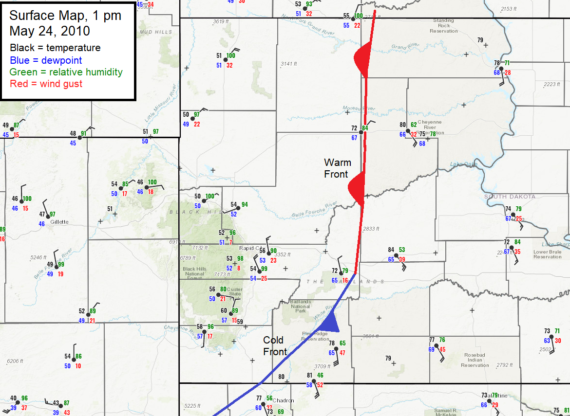 |
| Sounding for Rapid City at 12 pm MDT 24 May 2010 (18z UTC) | Hodograph for Rapid City at 12 pm MDT 24 May 2010 (18z UTC) | Surface map valid 1 pm MDT 24 May 2010 |
 |
Media use of NWS Web News Stories is encouraged! Please acknowledge the NWS as the source of any news information accessed from this site. |
|

