Tropical Depression Two is expected to gradually strengthen and could bring tropical storm conditions to the Florida Panhandle beginning late Monday. Areas of flash flooding will be possible through Thursday along the eastern and central Gulf Coast. Severe thunderstorms will develop and move along a cold front crossing the Upper Midwest Monday, and through the Ohio Valley/Mid-Atlantic on Tuesday. Read More >
Overview
|
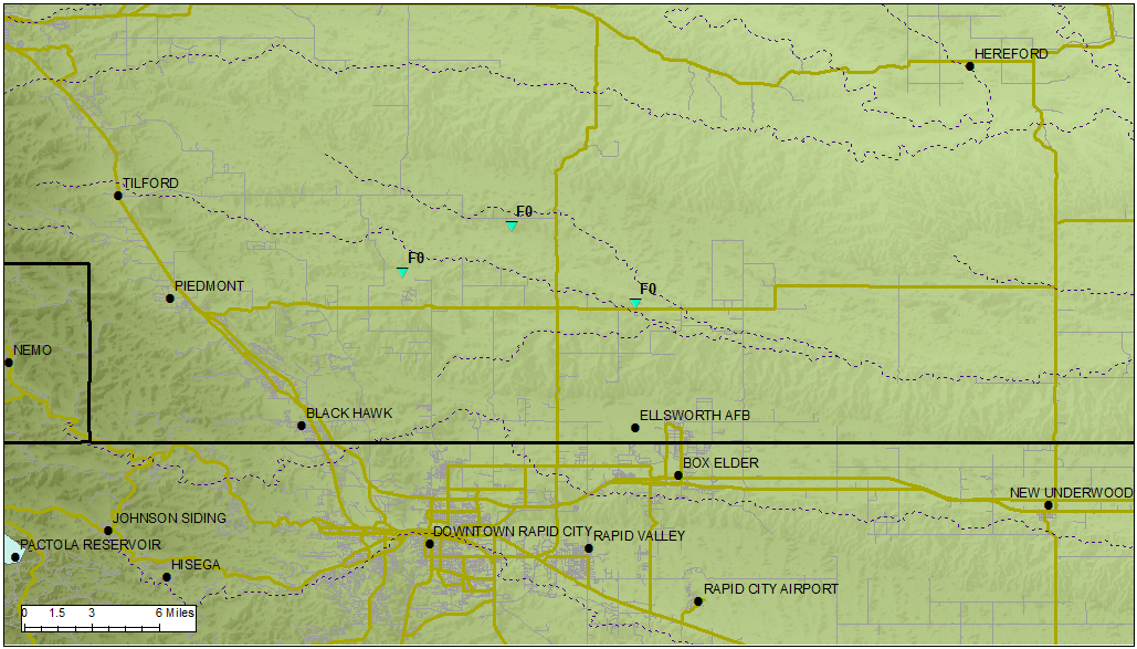
During the late afternoon and early evening of June 23, 1998, a slow-moving supercell thunderstorm produced a series of three tornadoes about 15 to 20 miles north-to-northeast of downtown Rapid City, South Dakota. Luckily, little damage was caused by these impressive tornadoes as they slowly moved eastward, to the north of I-90 and Ellsworth Air Force Base. There also was considerable crop damage associated with this supercell as it moved through Meade County. One observer reported hen egg size hail (2") falling for over an hour as the storm continuously re-developed over the same area. This page briefly outlines the meteorological conditions and radar imagery associated with this event. |
|
Tornadoes
|
Tornado #1 - 15 mi North of Rapid City, SD
Photo of Tornado #1 by Molly Zeitler 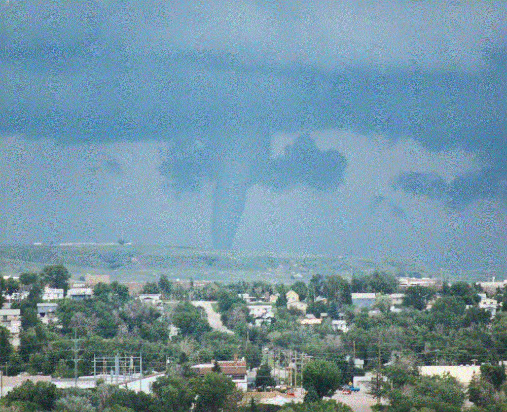
Photo of Tornado #1 by Tom Warner 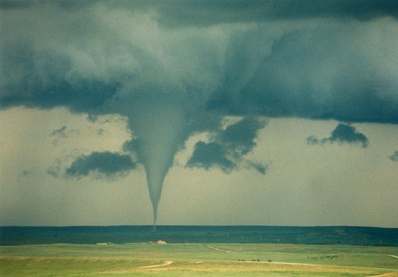 |
||||||||||||||||
|
Tornado #2 - 17 mi Northeast of Rapid City, SD
Photo of Tornado #2 Near Ellsworth AFB 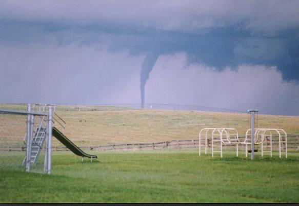 |
||||||||||||||||
|
Tornado #3 - 21 mi Northeast of Rapid City, SD
Photo of Tornado #3 by Ron Racicky 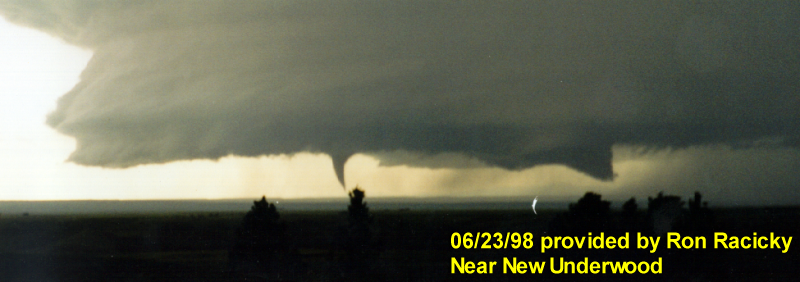
Photo of Tornado #3 by Tom Warner 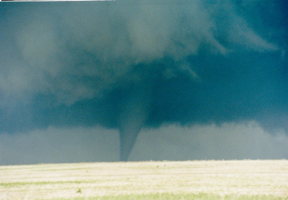 |
||||||||||||||||
Tornado ratings are assigned based on the amount of damage they cause. The tornadoes in southern Meade County were rated using the original Fujita tornado damage scale (http://www.spc.noaa.gov/faq/tornado/f-scale.html). In 2007, the National Weather Service began using the Enhanced Fujita (EF) scale (http://www.spc.noaa.gov/faq/tornado/ef-scale.html), which is an updated F-scale developed by a team of meteorologists and wind engineers.
The Enhanced Fujita (EF) Scale classifies tornadoes into the following categories:
| EF0 Weak 65-85 mph |
EF1 Moderate 86-110 mph |
EF2 Significant 111-135 mph |
EF3 Severe 136-165 mph |
EF4 Extreme 166-200 mph |
EF5 Catastrophic 200+ mph |
 |
|||||
Radar
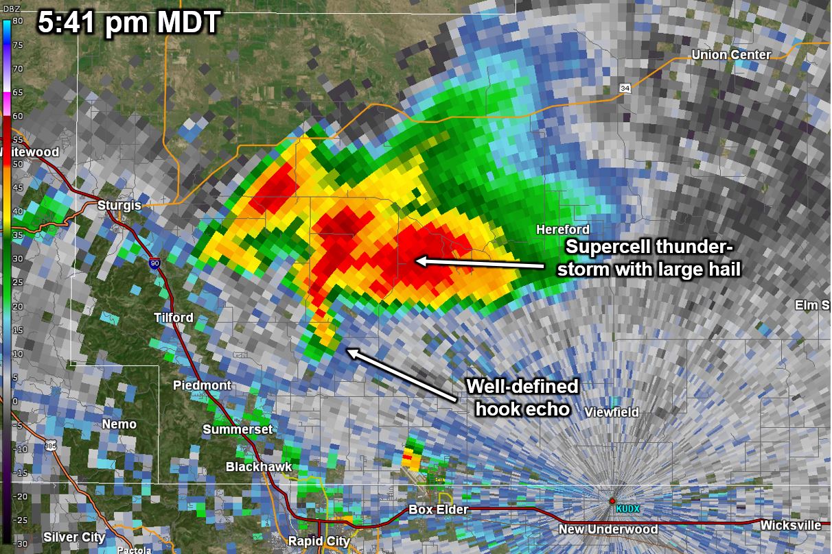
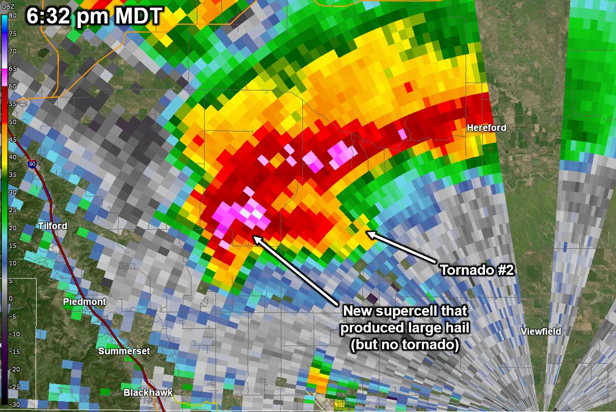
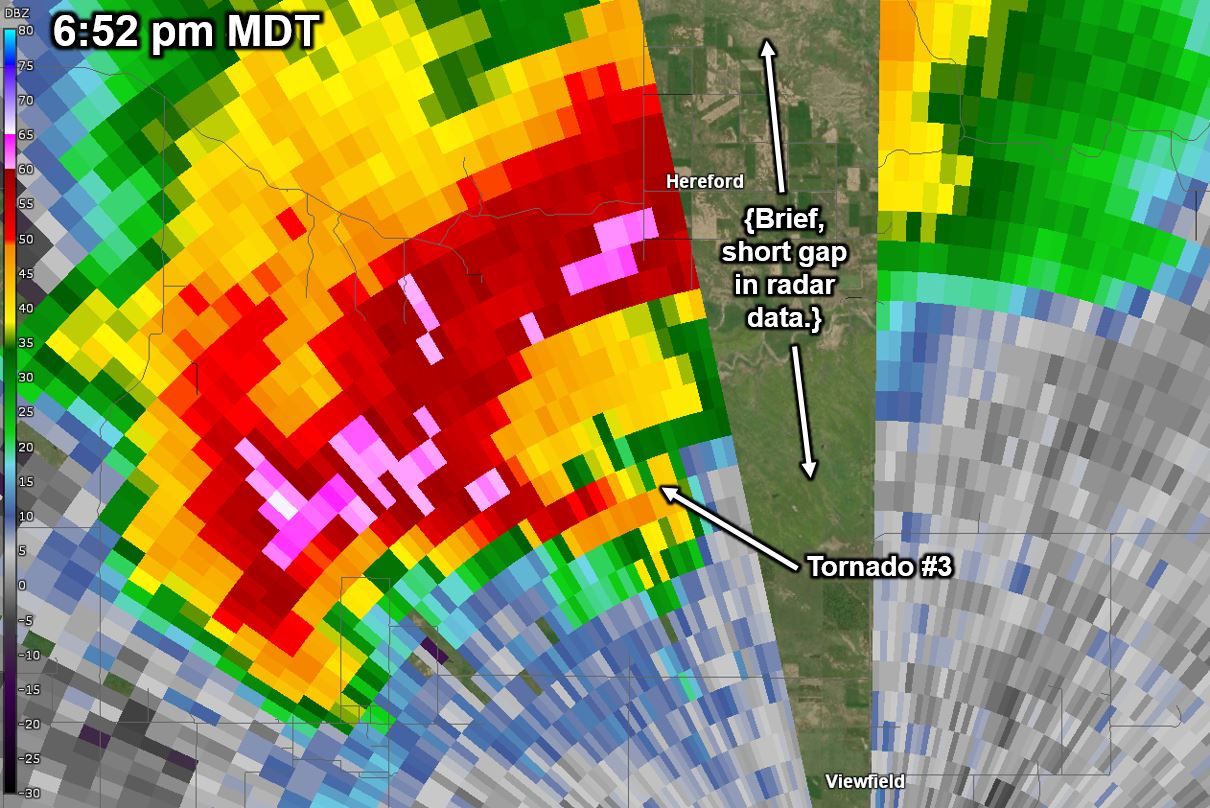
The tornado-producing storm was initiated downstream (downwind) of the Black Hills, about 20 miles northwest of Rapid City, at approximately 4:30 pm MDT. The storm quickly became severe, and soon developed a vivid hook echo (first image below, left), with strong convergent rotation (second image below, right) by 5:41 pm. The first tornado developed within this initial mesocyclone at 6:03 pm, about 15 miles to the north of downtown Rapid City. Note that the reflectivity features were not as striking at the time of the tornadic development as they were about 20 minutes earlier (see second row of images below). This initial tornado lasted approximately 10 minutes, becoming quite visually impressive, even from the Rapid City NWS office. At about this time, the radar showed a secondary appendage/hook echo quickly forming on the southwest flank of the initial storm. By 6:30 pm, a thin, rope-like tornado formed east of this new mesocyclone/appendage, which lasted about 5 minutes. At this time, the storm exhibited two strong mesocyclones and appendages (hooks). As the storm slowly progressed to the east, the primary (eastern) mesocyclone strengthened considerably and produced the third tornado from this storm at 6:50 pm. This was the last confirmed tornado with this storm, though it continued to exhibit strong rotation for over another hour or two. This series of tornadoes was perhaps one of the best observed tornadic events from Rapid City, as all three were easily visible from many locations.
| Radar animation from 4:01 to 9:17 pm MDT of the supercell storm that produced three tornadoes north and northeast of Rapid City, SD |
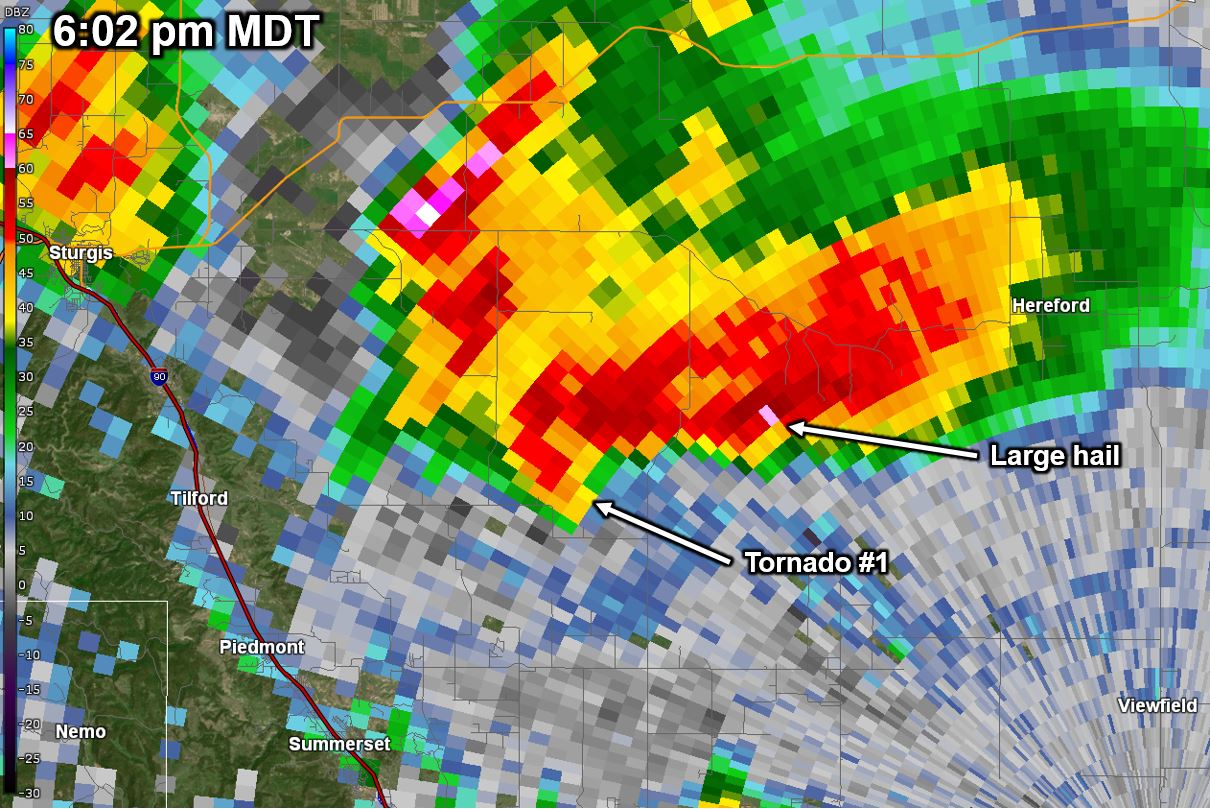
Radar Images for Tornado #1
 |
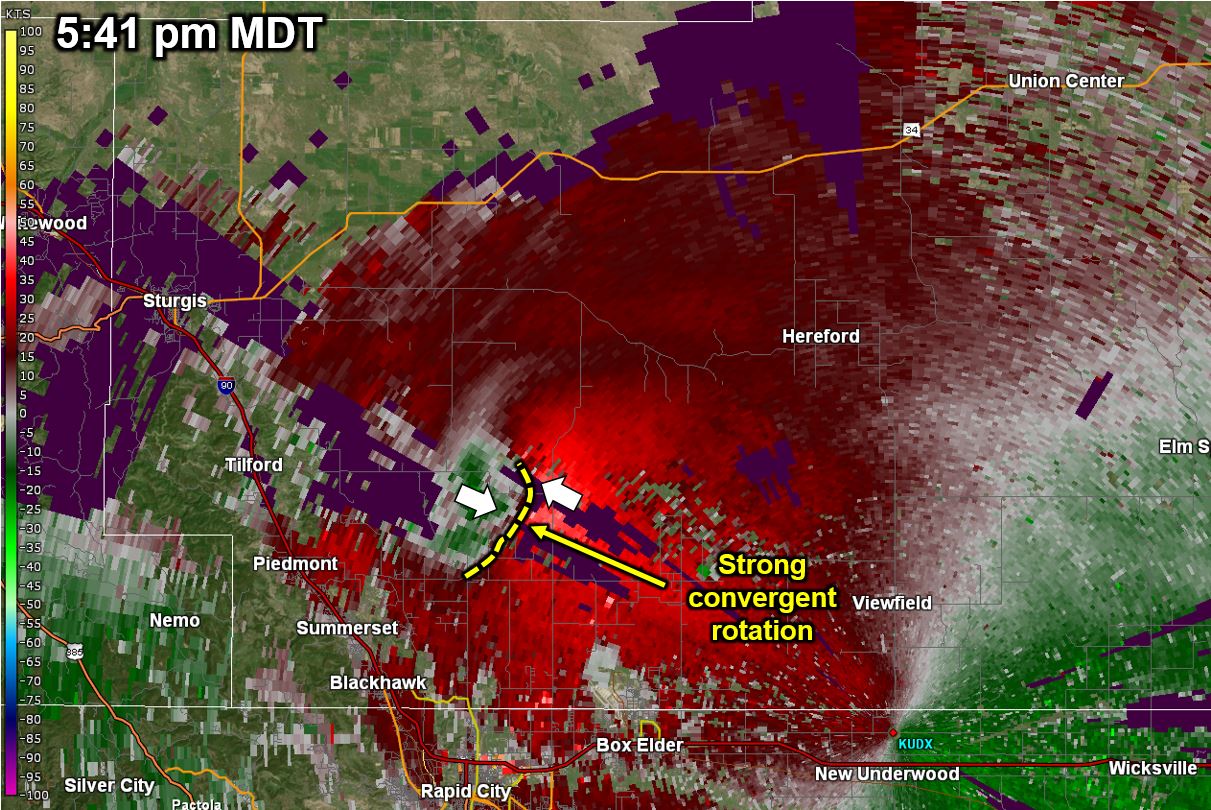 |
| Radar reflectivity at 5:41 pm, 22 min prior to tornado #1 | Radar velocity at 5:41 pm, 22 min prior to tornado #1 |
 |
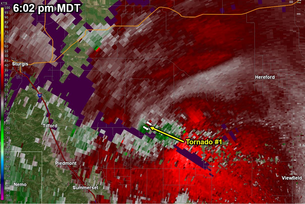 |
| Radar reflectivity at 6:02 pm, 1 min prior to tornado #1 | Radar velocity at 6:02 pm, 1 min prior to tornado #1 |
Radar Images for Tornado #2
 |
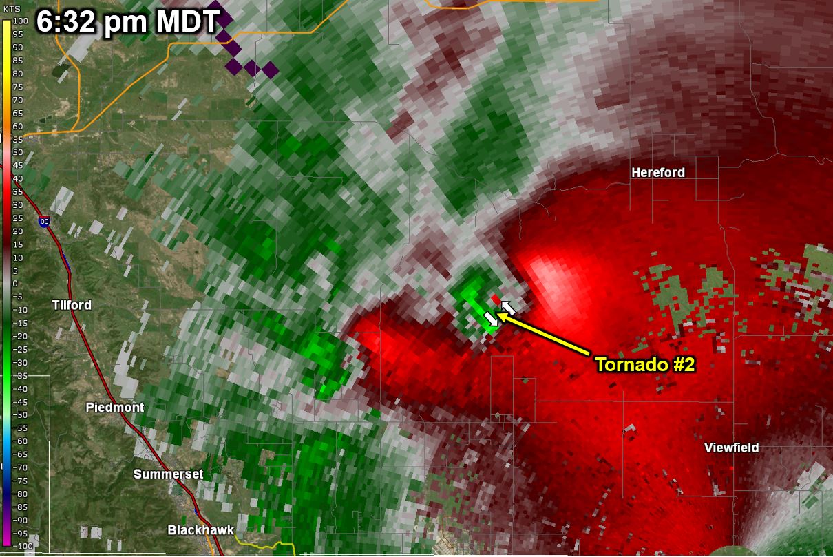 |
| Radar reflectivity at 6:32 pm, 2 min after to tornado #2 developed | Radar velocity at 6:32 pm, 2 min after to tornado #2 developed |
Radar Images for Tornado #3
 |
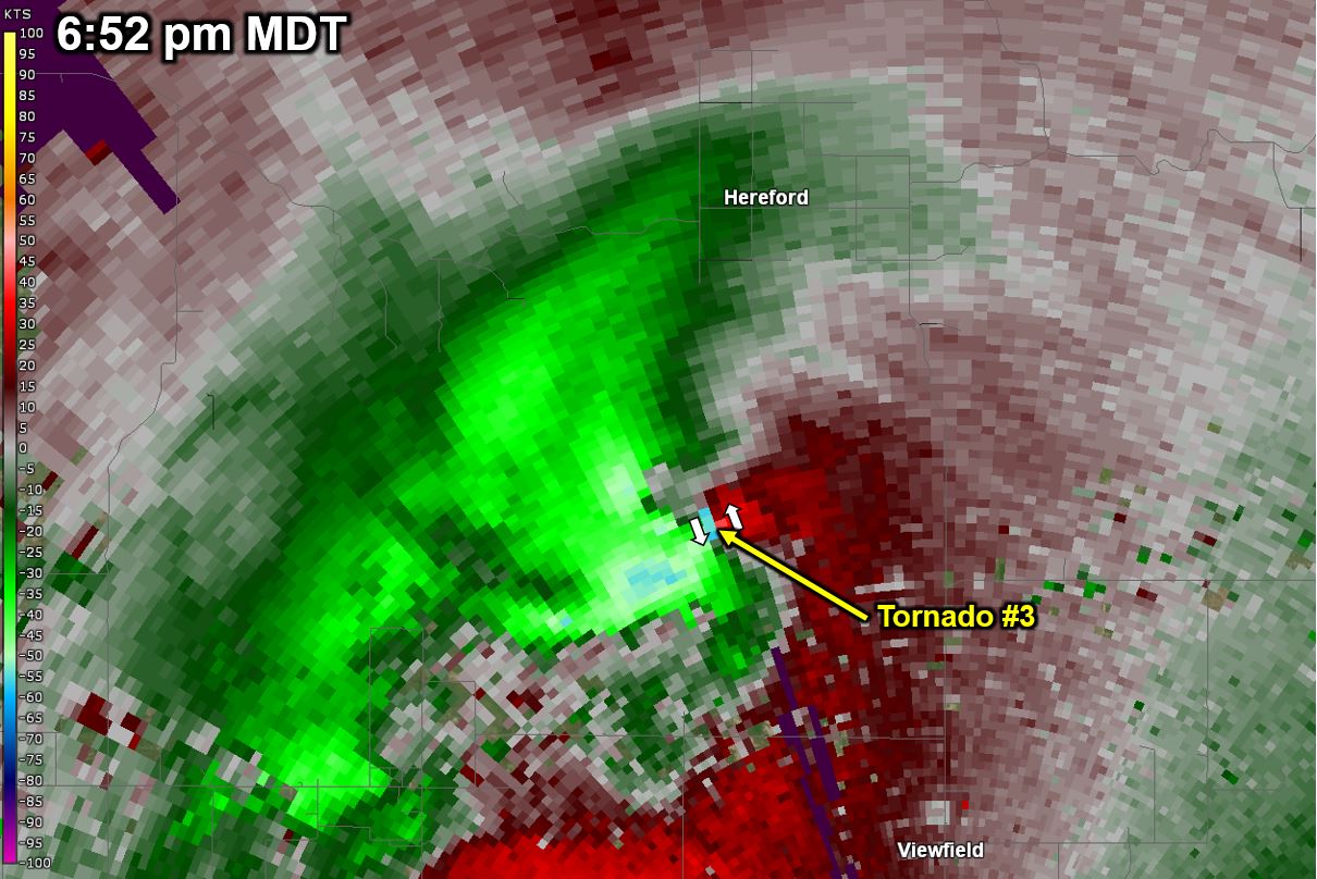 |
| Radar reflectivity at 6:52 pm, 2 min after to tornado #3 developed | Radar velocity at 6:52 pm, 2 min after to tornado #3 developed |
Radar Algorithm Output for all Tornadoes
Here is a listing of the WSR-88D tornado detection algorithm (TDA) algorithm output for this event. TVS stands for tornadic vortex signature, which is a tight rotational couplet observed by the WSR-88D at the lowest elevation scan (0.5 degrees). ETVS is an elevated TVS that is not evident on the lowest elevation of the radar (i.e., it is above 0.5 degrees).
| Time (MDT) | WSR-88D Output |
|---|---|
| 4:57 | ETVS |
| 5:02 | — |
| 5:07 | — |
| 5:12 | ETVS |
| 5:17 | — |
| 5:22 | ETVS |
| 5:27 | — |
| 5:32 | ETVS |
| 5:37 | TVS |
| 5:42 | — |
| 5:47 | — |
| 5:52 | TVS |
| 5:57 | — |
| 6:02 | TVS |
| 6:03 | Tornado #1 |
| 6:07 | ETVS |
| 6:12 | ETVS |
| 6:17 | ETVS |
| 6:22 | — |
| 6:27 | ETVS |
| 6:30 | Tornado #2 |
| 6:32 | TVS |
| 6:37 | — |
| 6:42 | TVS |
| 6:47 | TVS |
| 6:50 | Tornado #3 |
| 6:52 | TVS |
| 6:57 | TVS |
| 7:02 | — |
| 7:07 | — |
| 7:12 | — |
| 7:17 | ETVS |
Environment
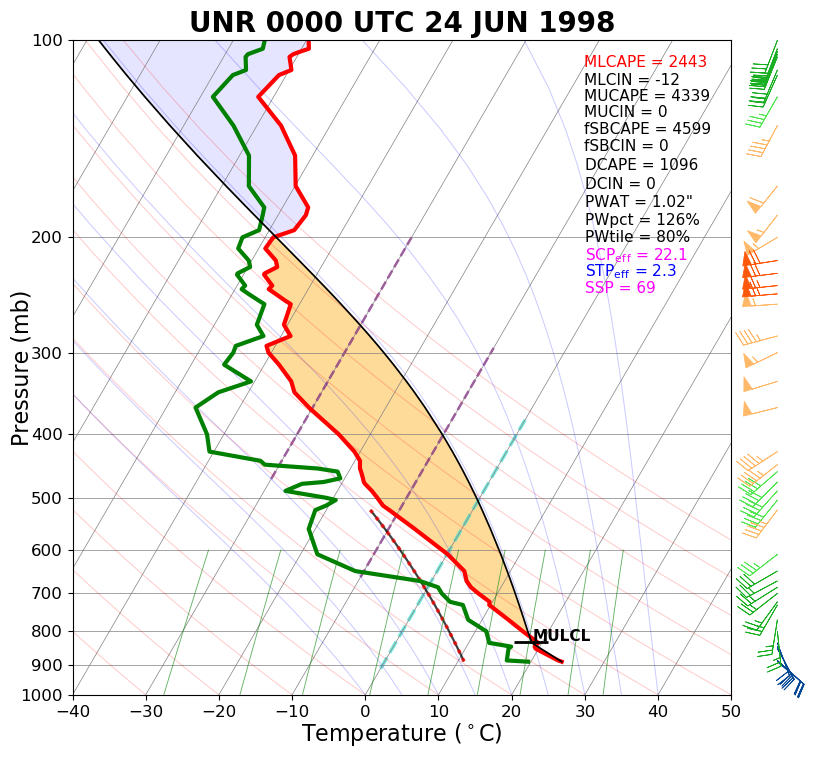
The atmosphere was very unstable throughout much of the early afternoon of June 23rd, with weak (20 kt or 23 mph) southwest flow aloft. Several strong, but transient storms formed in this unstable (CAPE ~ 2000 J/kg, lifted index = –6) environment in a convergent area downstream (to the northeast) of the Black Hills (approximately 20 miles north-northwest of Rapid City). Some large hail (up to 1.75" diameter) was reported with these short-lived early afternoon storms. From 1:00 to 4:00 pm, the atmospheric wind shear increased significantly (as the surface winds strengthened out of the southeast), and the atmosphere further destabilized (CAPE ~ 4000 J/kg, lifted index = –13), allowing for the explosive formation of more organized (supercellular) tornadic storms. The atmospheric conditions within which the storms developed are well represented by the skewT/logP and hodograph displays from the June 24th, 00Z (6:00 pm MDT, June 23rd) Rapid City sounding (seen below). More information about the displays below can be found here.
 |
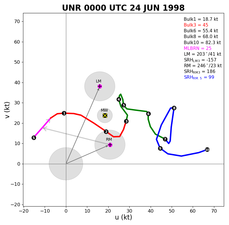 |
| SkewT/lopP display from the weather balloon released at NWS Rapid City (valid 6 pm MDT) | Hodograph display from the weather balloon released at NWS Rapid City (valid 6 pm MDT) |
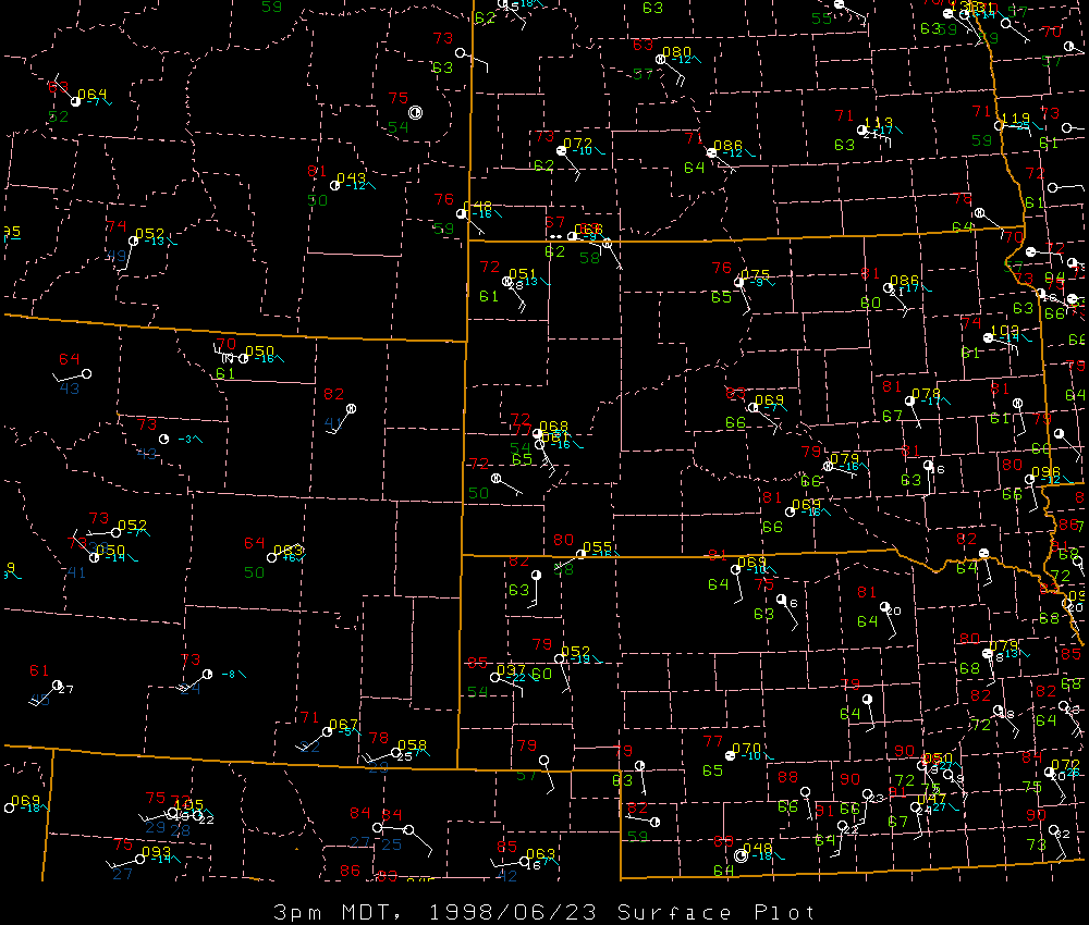
The surface maps showed a southeast surface wind that was bringing moist and unstable air into the Black Hills area. Temperatures at the Rapid City Airport from 3:00 to 5:00 pm where around 77°F and dewpoints were 65-66°F. This air was feeding into the tornadic thunderstorm to the north of Rapid City.
 |
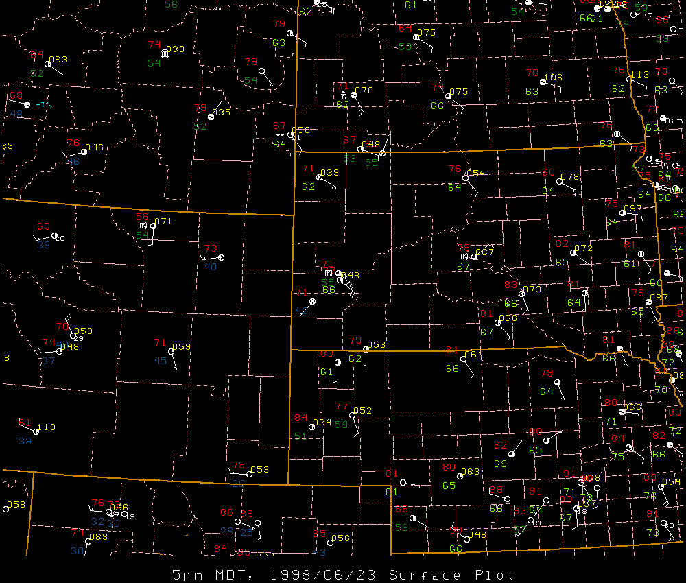 |
| Surface weather map centered on the Black Hills (valid 3 pm MDT) | Surface weather map centered on the Black Hills (valid 5 pm MDT) |
 |
Media use of NWS Web News Stories is encouraged! Please acknowledge the NWS as the source of any news information accessed from this site. |
|