
Tropical Depression Two is expected to gradually strengthen and could bring tropical storm conditions to the Florida Panhandle beginning late Monday. Areas of flash flooding will be possible through Thursday along the eastern and central Gulf Coast. Severe thunderstorms will develop and move along a cold front crossing the Upper Midwest Monday, and through the Ohio Valley/Mid-Atlantic on Tuesday. Read More >
Overview
|
The strongest tornado recorded in South Dakota tracked across eastern Tripp County on May 8, 1965. It was part of a large tornado outbreak caused by a strong spring storm that moved from Colorado into central South Dakota. A total of 30 tornadoes were reported in Nebraska and South Dakota during the afternoon through late evening. As moisture wrapped around the storm, it encountered very cold air over the northern plains and produced heavy snow over the Black Hills area. The Rapid City airport received 8.8 inches of snow, while Lead measured 36 inches of snow. Other reports included 25 inches at Hill City, 22.5 inches at Mount Rushmore, 18 inches at Pactola Reservoir, and 16 inches at Fort Meade (east of Sturgis). Even towns on the plains had significant snowfall, with Belle Fourche reporting 10 inches, Newell 8 inches, and Oelrichs 5.2 inches. |
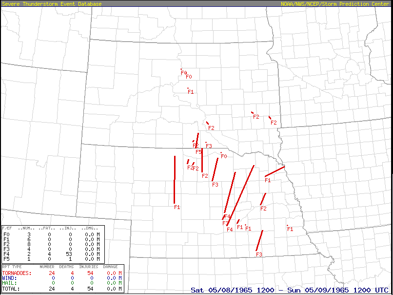 Tornado tracks on May 8, 1965 (red lines and points) |
Tornadoes:
|
Tornado - East of Wewela to Northeast of Colome, SD
Track Map 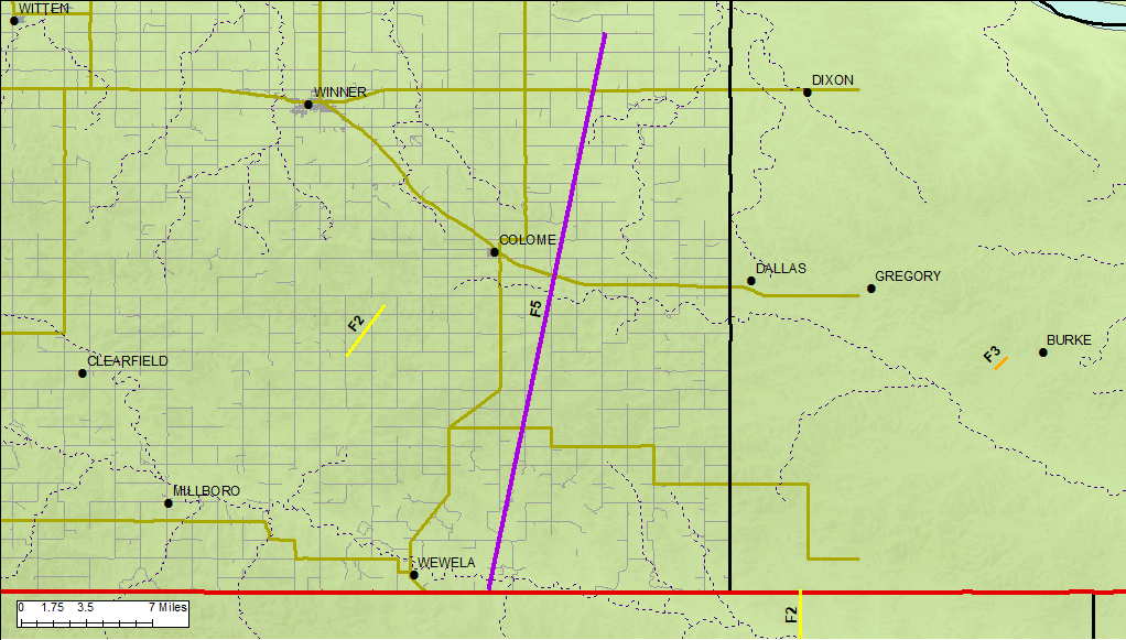  |
||||||||||||||||
|
Tornado - Southwest of Colome, SD
Track Map 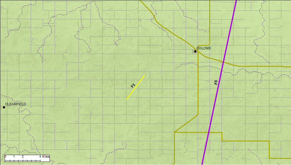 |
||||||||||||||||
Tornado ratings are assigned based on the amount of damage they cause. The tornadoes in eastern Tripp County were rated using the original Fujita tornado damage scale (http://www.spc.noaa.gov/faq/tornado/f-scale.html). In 2007, the National Weather Service began using the Enhanced Fujita (EF) scale (http://www.spc.noaa.gov/faq/tornado/ef-scale.html), which is an updated F-scale developed by a team of meteorologists and wind engineers. NWS tornado records started in 1950.
The Enhanced Fujita (EF) Scale classifies tornadoes into the following categories:
| EF0 Weak 65-85 mph |
EF1 Moderate 86-110 mph |
EF2 Significant 111-135 mph |
EF3 Severe 136-165 mph |
EF4 Extreme 166-200 mph |
EF5 Catastrophic 200+ mph |
 |
|||||
News Account
The following article about the tornado appeared in the May 13, 1965 issue of the “Winner Advocate” and was provided by the editor.
Violent Tornado Rips Across Eastern Tripp County: Twenty-three Farms Ravaged in Storm’s Fifteen Mile Path
The most violent storm to hit Tripp County in recent years left a trail of disaster and destruction fifteen miles long in Eastern Tripp County last Saturday afternoon.
The thirty minutes of devastation sent one man to the hospital and completely destroyed seven farm homes while ripping to shreds outbuildings on farms from the Nebraska border east of Wewela on north of Highway 18 east of Colome.
The only injury that required hospitalization from the storm was to William Musilek who lives about ten miles south of Colome. He was taken to the Gregory Hospital with several broken ribs and a punctured lung and is currently reported in satisfactory condition.
The injured man was returning home in his car, when the tornado struck, tossing his car on top of high line wires and flinging it near his house. Musilek was able to crawl from the auto to the house where his family had taken refuge in the basement of the home.
HAIL DAMAGE
While the fury of the storm spent itself in eastern Tripp County, Winner was being blasted by hail and high winds which caused thousands of dollars of damage to windows, roofs, store signs and hundreds of autos.
The hail, which reportedly was the size of golf balls, buried the western half of Winner in over [sic] inches of ice and slush while the eastern half of the city received lesser hail amounts.
Winner’s official weather observer, Mrs. Rollin Key, stated that three inches of rain fell throughout Saturday with 1.60 inches falling between 6 and 7 p.m. An inch and one-quarter was reported prior to the 6 p.m. drenching and an additional .15 fell after 7 p.m.
While Winner was receiving three inches, the tornado area south of Colome received only twenty hundredths of an inch. A report from the Millboro area indicated that about three and one-half inches fell in about 45 minutes between 4:30 and 5:15 p.m. A small amount of hail was reported in that area with the heavy rains causing some roads to be washed out.
HAMILL TWISTER
A report from the Hamill area stated that a twister was sighted in the area of the John Fiala and the Jack Lynass farms about eleven miles east and four miles north of Winner. Damage at the Lynass farm included a chicken house which was blown over. There was also a report of damaged feed bunks at the Fiala farm and some fences and gates were ripped up at the Joe Orel farm in that area.
Some hail was reported in the Hamill area where nearly three and one half inches of rain were reported. Some places west of Hamill received four inches from Saturday’s drenching.
A report from the Witten area indicated the about one and one half inches of rain fell between 4:30 and 5:30 p.m. There was no report of hail or high winds in the Witten vicinity.
INSURANCE CLAIMS
Insurance agents throughout the Winner area have been deluged with claims from storm damage. The claims, which have been keeping local agents working through the evening hours, range from total losses on buildings and livestock in the tornado area to reports of lesser damage in the Winner vicinity.
The tremendous wind and force which drove the golf ball sized hail in Winner caused damage to hundreds of autos with reports ranging from minor dents to estimates of over $200 in smashed paint jobs.
CALL OUT GUARD
Tripp County Sheriff James E. Storms, who worked through Saturday night covering the storm damage in the Colome area along with deputy Louis Hespe and highway patrolman Laverne Nye, reported that the 730th Medical Clearing Company of the National Guard in Winner was called into action on Sunday.
The total damage suffered to farmers south of Colome appeared to be open for possible looting, but National Guardsmen were called in from noon Sunday until late Sunday evening to prevent any possible thievery. According to Sheriff Storms, there were no actual reports of looting at any of the damage locations.
POWER SHORTAGE
The Winner, Bonesteel and Gregory areas were without power starting at 5:25 p.m. on Saturday evening as a result of the storm.
According to Rosebud Electric Cooperative officials, four large structures on the Bureau 115,000 volt transmission line were snapped off by the high winds. Power was restored to Gregory and Bonesteel fifteen minutes later, but Winner was forced to use their emergency power facilities for a time until power was restored after 6 p.m.
TORNADO VICTIM FUND
Officials of the Citizen’s Bank of Colome have announced that a fund for the financial assistance of victims of the tornado has been started at their institution.
They announced that funds have already been arriving for the tornado salvage assistance and added that the entire fund will be distributed to victims of the storm.
TORNADO DAMAGE
Although reports of additional tornado and wind damage are still coming in, a list of victims and damages has been compiled by Sheriff Storms. Included in the list of victims are twenty-seven areas both in Tripp County and Nebraska which were hit by the twisters.
The most severe tornado apparently touched down south east of Wewela in Nebraska and then followed a ravine for over fifteen miles north across Highway 118. A second twister apparently touched down about ten miles south of Winner to hit several farms in that area.
Damage at the Tom Holden farm south of Winner included a total loss of all out buildings and severe damage to the house. Mr. and Mrs. Holden and their two grandchildren were in the home at the time of the storm while a son, Merle, was tossed about in a car as he drove into the yard when the storm hit.
Other damage in this area included wind damage to the out buildings on the Joe Holden farm and lesser damage to outbuildings on the William Hahn and Maurice Steele farms. The barn on the Vernon Herrmann farm, south-east of Millboro also received some damage to fences, trees and telephone lines near the Nelson Smith farm in this area.
The largest of the two twisters apparently touched down near the John Van Heeder farm in Nebraska where the storm leveled the entire farmstead, including the house. Mrs. Von Heeder and a baby were in the house at the time but were not injured.
As the storm moved into Tripp County it destroyed a sheep barn and killed one calf on the Erv Croston farm.
The trail of destruction continued through the Otto Hauf farmstead completely demolishing the farm including the Hauf house and a vacant set of buildings just across the road. Mr. and Mrs. Hauf had driven into Winner and luckily were not at home when the twister hit.
Just a mile north of the Hauf farm, the tornado leveled the farm of Kenneth Kenzy, destroying the Kenzy home and surrounding outbuildings. Mr. Kenzy was able to escape the fury of the storm when his father-in-law saw the twister approaching and was able to drive away with the Kenzy family before it hit. Mrs. Kenzy was not at home at the time.
The farm buildings on the Howard Sorber farm, two miles north of the Kenzy farm, were completely leveled while Mrs. Sorber and her three grandchildren remained in one of the two houses which withstood the tornadic blast.
The damaging twister continued up eastern Tripp County leveling a granary and corn crib on the Dennis DeMers farm.
Continuing north the tornado completely destroyed the outbuildings on the William Musilek farm injuring Mr. Musilek who was driving home in his auto at the time. Other members of the Musilek family sought protection from the storm in the basement of the house which was severely damaged and is considered a total loss by authorities.
The farm of James and Phillip Musilek, located three miles east of the William Musilek farm, received severe damage when outbuildings and fences were torn down. A trailer house on this farm was also twisted from its moorings.
Additional damage was reported to the Donald Kaiser farm near the Musilek place where several outbuildings were lost and a vacant farmstead was completely demolished. The outbuildings of the Phil Shadeed farm near the Kaiser place were also demolished.
A pole barn at the Charles Hrabanek farm south and east of the Calvary Chapel was picked up by the twister and deposited in a heap neat the Hrabanek house.
The entire set of outbuildings at the Harley Fetzer farm were completely wiped out by the storm as Mr. Fetzer was thrown from his auto by the violence of the twister. He was not injured in the incident. Local authorities stated that the Fetzer house was also severely damaged.
Other buildings which were demolished in the storm’s fury included all the outbuildings on the farmsteads of Ray Neyens, Bill Donovan, Leonard Vobr and Bern Bertram.
In a final gust of fury before leaving the scene of violence, the twister completely demolished all the outbuildings on the Joe Stritecky farm north east of Colome. The Stritecky family took refuge in a cave while the storm was in progress. The Stritecky home was also severely damaged by the storm.
Local authorities have not yet been placed an estimate on the total amount of damage caused by the twister and speculated that this tornado may have been the same one seen in the Hamill area which caused some minor damage.
Environment
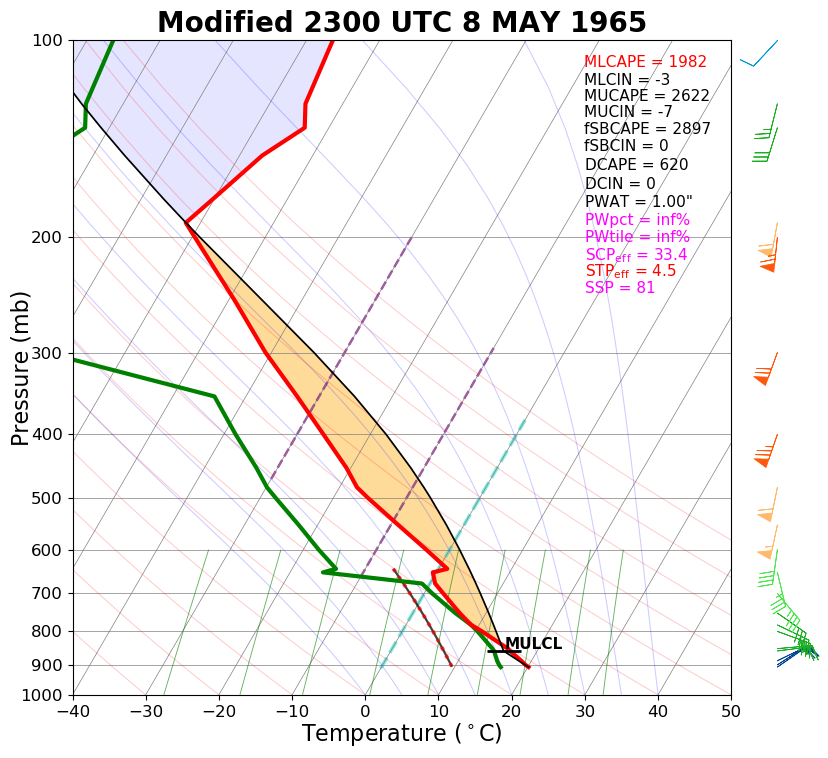
The NWS balloon information was interpolated between Rapid City, SD, and North Platte, NE, to come up with an estimate for the environment over Tripp County, SD. This information then was modified based on the surface pattern and our understanding of the severe storm environment. The resulting sounding suggests that a very unstable air mass with strong vertical wind shear was in place. This is a classic setup for major tornado outbreaks.
 |
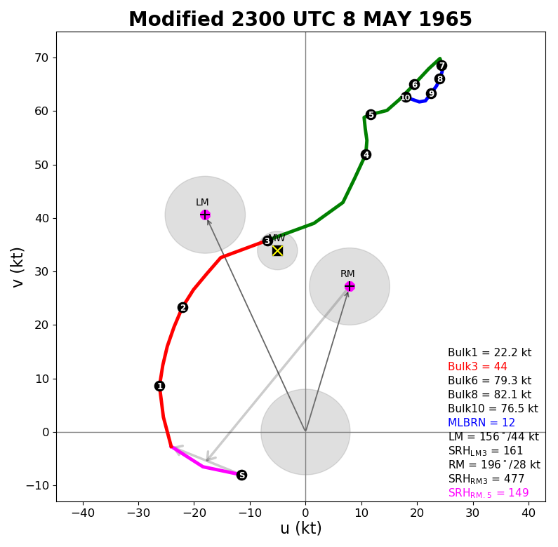 |
| Modified sounding for the Winner area at 6 pm CDT 8 May 1965 | Modified hodograph for the Winner area at 6 pm CDT 8 May 1965 |
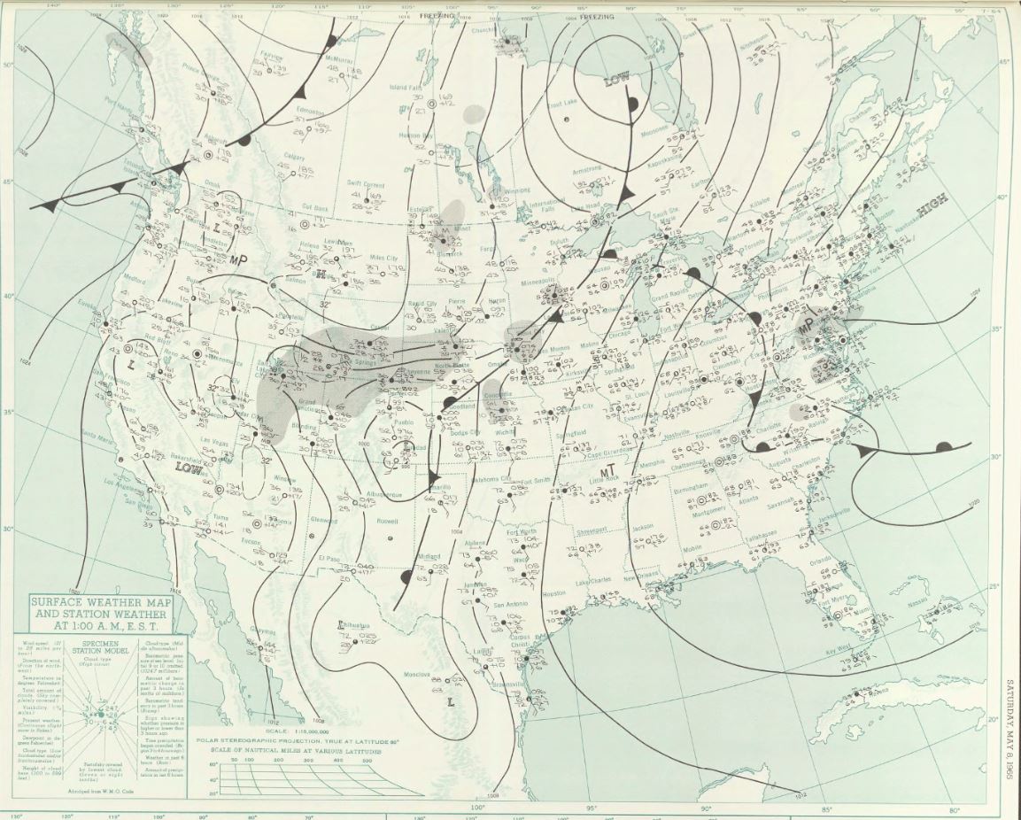
Surface observations were rather sparse and less frequent in 1965 compared to present day. As a result, the best surface maps were only available at midnight CDT. The left image below shows that a classic Colorado low pressure was taking shape about 18 hours prior to the tornadoes. Tripp County was in a cool and dry northwest flow at that time. This low then moved north-northeast to central Nebraska by late afternoon on May 8th (allowing warm, moist, and unstable air to move into Tripp County), and then the low moved into central South Dakota by midnight (right image below).
 |
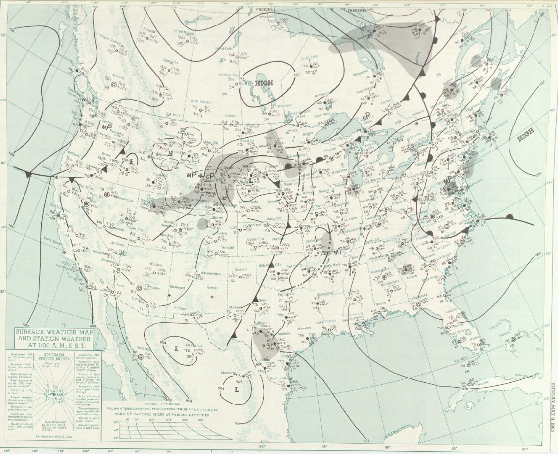 |
| Surface map at midnight CDT on 7 May 1965 (about 17-18 hours before the tornadoes) | Surface map at midnight CDT on 8 May 1965 (about 6-7 hours after the tornadoes) |
 |
Media use of NWS Web News Stories is encouraged! Please acknowledge the NWS as the source of any news information accessed from this site. |
|

