Christmas Eve Blizzard and Winter Storm 2009
Event Synopsis
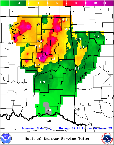
Blizzard and near blizzard conditions pummeled parts of eastern Oklahoma and northwest Arkansas Christmas Eve and into early Christmas morning, as an intense and deepening storm system moved through the Southern and Central Plains. Snowfall totals in excess of 6 inches were common across areas along and to the northwest of the Interstate 44 corridor, with lesser, but still significant amounts across much of the remainder of eastern Oklahoma and northwest Arkansas. Wind gusts in excess of 40 mph combined with the moderate to heavy snowfall to create dangerous blizzard and near blizzard conditions across much of the area. The wind gusts also resulted in isolated downed tree limbs and sporadic power outages.
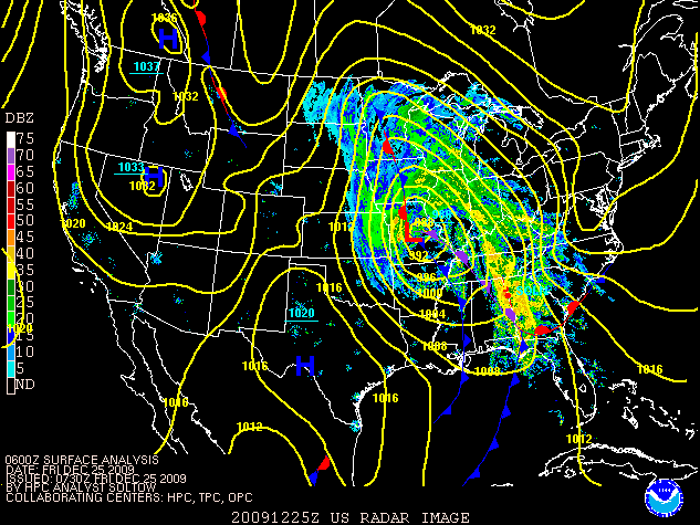
Eastern Oklahoma and northwest Arkansas began to feel the effects of the storm system as early as the night of Tuesday the 22nd. After an unseasonably warm Tuesday afternoon, overnight and early morning thunderstorms developed across portions of the area as moisture poured into the region. Additional thunderstorms developed Wednesday afternoon ahead of the cold front that moved through most of the area, except northwest Arkansas, by late that evening. The afternoon thunderstorms produced hail to a half inch in diameter, including in the Tulsa metro area. More widespread rain showers spread into the region early morning on Christmas Eve, as the storm system moved across north Texas. As the cold air became deeper, the rain gradually transitioned to sleet, and then, snow in a west to east fashion. Blizzard conditions quickly developed once the transition to snow occurred, as the winds had already begun to gust above 35 mph. The snow and blizzard conditions slowly came to an end late on Christmas Eve and early Christmas Day from west to east as the storm system moved quickly into the Upper Midwest.
Snowfall Totals

 |
|
The visible satellite image is from Christmas morning at 10:15 AM and shows the wide swath of snow put down by the storm. Note how the unfrozen rivers and lakes show up dark in the image. |
First Blizzard Warning for Tulsa County; Second Blizzard Warning Issued by NWS Tulsa
Blizzard conditions are highly unusual in eastern Oklahoma and northwest Arkansas. In fact, they are so rare that Christmas Eve marked the first Blizzard Warning ever issued for Tulsa County; it was also only the second Blizzard Warning ever issued by the National Weather Service in Tulsa. The only previous Blizzard Warning for eastern Oklahoma or northwest Arkansas was issued on November 30th, 2006, and included Osage, Pawnee, Washington (Oklahoma), Nowata, Craig, and Ottawa counties.
A Blizzard Warning was initially issued for Osage, Pawnee, and Creek counties at 10:50 am Christmas Eve morning. It was later expanded at 2:21 pm to also include Tulsa, Washington, Nowata, Craig, Ottawa, Rogers, Mayes, Delaware, Okfuskee, Okmulgee, McIntosh, Muskogee, Wagoner, and Cherokee counties.
White Christmas for Tulsa and Fort Smith
A White Christmas is defined as an inch of snowfall on the ground Christmas morning, and Tulsa and Fort Smith both recorded an official White Christmas for 2009. Tulsa previously had White Christmases in 2002, 2000, 1983, and 1966. Fort Smith had White Christmases in 1990, 1975, and 1963.
Maximum Measured Wind Gusts Above 40 mph
|
Location |
Wind Gust |
|
Tulsa County |
|
| Tulsa International Airport (ASOS) | 48 mph |
| Bixby (Mesonet) | 43 mph |
|
Osage County |
|
| Foraker (Mesonet) | 52 mph |
| Burbank (Mesonet) | 49 mph |
| Wynona (Mesonet) | 47 mph |
| Skiatook (Mesonet) | 42 mph |
|
Washington County (Oklahoma) |
|
| Copan (Mesonet) | 42 mph |
|
Nowata County |
|
| Nowata (Mesonet) | 47 mph |
|
Pawnee County |
|
| Pawnee (Mesonet) | 43 mph |
|
Rogers County |
|
| Claremore (Mesonet) | 51 mph |
| Inola (Mesonet) | 41 mph |
|
Creek County |
|
| Bristow (Mesonet) | 43 mph |
| Oilton (Mesonet) | 40 mph |
|
Wagoner County |
|
| Porter (Mesonet) | 48 mph |
|
Okfuskee County |
|
| Okemah (Mesonet) | 49 mph |
|
Okmulgee County |
|
| Okmulgee (AWOS) | 48 mph |
| Hectorville (Mesonet) | 43 mph |
| Okmulgee (Mesonet) | 41 mph |
|
Muskogee County |
|
| Muskogee (ASOS) | 52 mph |
| Haskell (Mesonet) | 44 mph |
| Webbers Falls (Mesonet) | 40 mph |
|
Pittsburg County |
|
| McAlester (Mesonet) | 46 mph |
| Stuart (Mesonet) | 45 mph |
| McAlester (ASOS) | 40 mph |
Surface Maps and Radar Imagery
 |
 |
 |
 |
 |
|
6 am CST December 24 |
12 pm CST December 24 |
6 pm CST December 24 |
12 am CST December 25 |
6 am CST December 25 |
|
Maps Courtesy of the Hydrometeorological Prediction Center |
||||