Overview
A powerful storm system tracked across the upper midwest with a trailing cold front that swept through the Missouri Ozarks and southeast Kansas. While we were on the warm side of this storm system, not much instability developed over the area which was held down by the clouds and rainfall during the day. There was just enough to get develop some line segments as we had plenty of shear and system dynamics. Very little to no lightning occurred with this severe weather event that produced some wind damage and a tornado near Fair Play, MO.Tornadoes:
|
Near Fair Play
Track Map 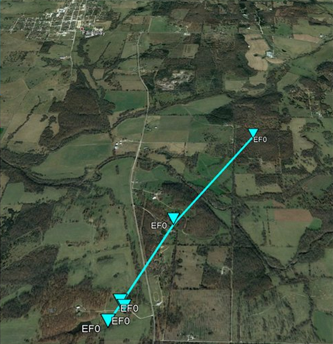 
Downloadable KMZ File |
||||||||||||||||
The Enhanced Fujita (EF) Scale classifies tornadoes into the following categories:
| EF0 Weak 65-85 mph |
EF1 Moderate 86-110 mph |
EF2 Significant 111-135 mph |
EF3 Severe 136-165 mph |
EF4 Extreme 166-200 mph |
EF5 Catastrophic 200+ mph |
 |
|||||
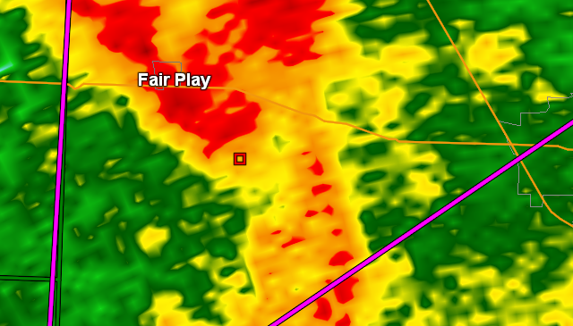
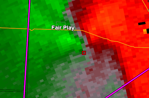
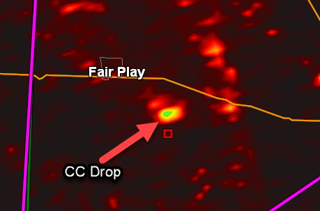
Radar
Fair Play Tornado - Radar Images
 |
 |
 |
|
| Fair Play Tornado - Reflectivity | Fair Play tornado - Storm Relative Velocity | Fair Play Tornado - Correlation Coefficient |
Storm Reports

PRELIMINARY LOCAL STORM REPORT...SUMMARY
NATIONAL WEATHER SERVICE SPRINGFIELD MO
829 PM CST SUN DEC 29 2019

..TIME...   ...EVENT...      ...CITY LOCATION...     ...LAT.LON...
..DATE...   ....MAG....      ..COUNTY LOCATION..ST.. ...SOURCE....
            ..REMARKS..

1101 PM     TSTM WND GST     3 E LANTON              36.52N 91.75W
12/28/2019  E60 MPH          HOWELL             MO   EMERGENCY MNGR

            CORRECTS PREVIOUS TSTM WND GST REPORT FROM 3
            E LANTON. ESTIMATED WINDS OF 60 MPH. ALSO
            SOME TREES DOWN IN LANTON.

1011 PM     TSTM WND GST     GENTRYVILLE             36.86N 92.36W
12/28/2019  E60 MPH          DOUGLAS            MO   AMATEUR RADIO

            STRONG WINDS IN GENTRYVILLE AND NOW MOVING
            INTO DRURY AND VANZANT IN EASTERN DOUGLAS
            COUNTY FIRE DEPARTMENT IS EST. WINDS SPEEDS
            60 MPH.

1054 PM     TSTM WND DMG     5 NNW LANTON            36.58N 91.83W
12/28/2019                   HOWELL             MO   EMERGENCY MNGR

            UPDATES PREVIOUS TSTM WND DMG REPORT FROM 5
            NNW LANTON. TREE ON CAR AND HOUSE. TWO TREES
            ACROSS HIGHWAY. ABOVE GROUND POOL DISPLACED.
            TIME BASED ON RADAR.

0931 PM     TSTM WND DMG     4 W THEODOSIA           36.58N 92.75W
12/28/2019                   OZARK              MO   AMATEUR RADIO

            SEMI TRAILER MOVED 8 FEET AND TIPPED OVER.
            TREES BLOWN OVER. TIME BASED ON RADAR.
            DELAYED REPORT.

0929 PM     TSTM WND DMG     5 W THEODOSIA           36.57N 92.77W
12/28/2019                   TANEY              MO   AMATEUR RADIO

            REPORT OF TREES DOWN. TIME BASED ON RADAR.

0706 PM     TSTM WND DMG     2 E FAIR PLAY           37.63N 93.54W
12/28/2019                   POLK               MO   EMERGENCY MNGR

            CORRECTS PREVIOUS TSTM WND DMG REPORT FROM 2
            E FAIR PLAY. MO 32 HIGHWAY AND S 50TH RD
            BOLIVAR, 3 BARNS SIGNIFICANT DAMAGE. THERE
            IS MOST OF ANOTHER BARN ON THAT PROPERTY
            THAT IS NOT FROM THAT PROPERTY. TIME BASED
            ON RADAR.

0703 PM     TSTM WND DMG     2 SSE FAIR PLAY         37.60N 93.56W
12/28/2019                   POLK               MO   EMERGENCY MNGR

            CORRECTS PREVIOUS TSTM WND DMG REPORT FROM 2
            SSE FAIR PLAY. TWO BARNS DESTROYED AND ONE
            HOUSE WITH ROOF DAMAGE. TIME BASED ON RADAR.

0508 PM     TSTM WND DMG     1 SSW FRONTENAC         37.44N 94.70W
12/28/2019                   CRAWFORD           KS   AMATEUR RADIO

            DELAYED REPORT. TIME ESTIMATED FROM RADAR OF
            A FEW LIMBS BROKEN NEAR PITTSBURG, KANSAS
            AREA.

0706 PM     TORNADO          2 SE FAIR PLAY          37.61N 93.55W
12/28/2019                   POLK               MO   NWS STORM SURVEY

            END POINT OF FAIR PLAY TORNADO. FARM
            BUILDINGS DAMAGED AND TREES UPROOTED.
            TORNADO WAS ON THE GROUND FOR 3 MINUTES.

0703 PM     TORNADO          2 S FAIR PLAY           37.59N 93.57W
12/28/2019                   POLK               MO   NWS STORM SURVEY

            STARTING POINT FOR FAIR PLAY TORNADO. FARM
            BUILDINGS DAMAGED AND TREES UPROOTED.
            TORNADO WAS ON THE GROUND FOR 3 MINUTES.
 |
Media use of NWS Web News Stories is encouraged! Please acknowledge the NWS as the source of any news information accessed from this site. |
|


 Weather Story
 Weather Map
 Local Radar