Springfield, MO
Weather Forecast Office
 |
Strong Winds, Heavy Rain and Snow March 16-17, 2014National Weather Service, Springfield, MO |
 |
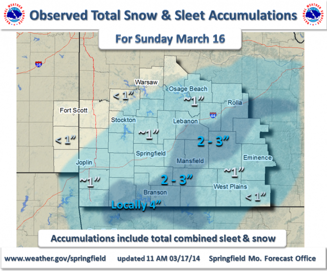
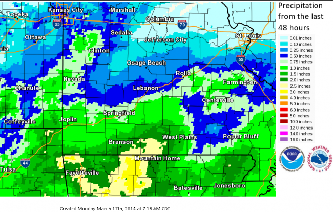
A strong area of low pressure lifted from the Arklatex region across Arkansas during the nighttime hours of March 15th through the day of March 16th, 2014. Strong winds developed early Sunday(3/16) morning with gusts of 35 to 45 mph as this low strengthend over Arkansas. Occasional heavy rainfall developed Saturday night and continue into Sunday. As colder air pushed in from the north during the morning into early afternoon Sunday, the rain gradually changed to some sleet and then snow. The highest precipitation and snow totals occurred across southern Missouri.
Current Hazards
Experimental Graphical Hazardous Weather Outlook
Submit a storm report
Local Storm Reports
Current Conditions
Observations
Lake Levels
Snowfall Analysis
Road Conditions
Satellite
CoCoRaHS
Graphical Conditions
Precip. Analysis
Forecasts
Forecast Discussion
Fire Weather
Aviation
GIS Forecast Maps
Activity Planner
Severe Weather
Winter Weather
Hurricanes
FAA Center Weather
Space Weather
Climatology
Records and Normals
Monthly Climate Summary
Local
National
Drought
Climate Science
Astronomical Data
US Dept of Commerce
National Oceanic and Atmospheric Administration
National Weather Service
Springfield, MO
Springfield-Branson National Airport
5805 West Highway EE
Springfield, MO 65802-8430
Business: 417-863-8028 Recording: 417-869-4491
Comments? Questions? Please Contact Us.


 Weather Story
 Weather Map
 Local Radar