National Weather Service United States Department of Commerce

Regional Outbreaks of Severe Weather Through Early Next Week; Early Season Heat Wave across the South

Active spring pattern across the center of our nation with several episodes of severe weather and heavy rainfall expected into next week. The potential for very large hail, long track tornadoes, severe wind gusts, frequent cloud to ground lightning strikes and flash flooding are in the outlook. Furthermore, dangerous early season heat wave continues for the Gulf Coast states into early next week. Read More >

Snowfall Across the Ozarks November 16th, 2014

National Weather Service, Springfield, MO
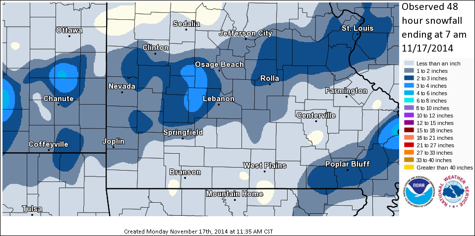
Event Summary

A quick moving upper level system pushed across the Missouri Ozarks and extreme southeast Kansas, interacting with cold air and moisture already in place to produce snowfall throughout the area. Snowfall began falling over extreme southeast Kansas into central Missouri by sunrise and spread south and east throughout the day. General snowfall amounts ranged from one to two inches, with some isolated higher amounts that occurred within some heavier snow bands.

...Snowfall Total...

LOCATION                       AMOUNT    TIME/DATE

...KANSAS...

...CRAWFORD...
PITTSBURG                          2.0 IN    0600 AM 11/17
CHEROKEE 0.3 N                2.0 IN    0711 AM 11/17

...MISSOURI...

...BARRY...
PURDY 4.8 SSW                  0.5 IN    0652 AM 11/17

...BARTON...
LIBERAL 0.7 SSE                2.0 IN    0659 AM 11/17
GOLDEN CITY 0.6 SSW    2.0 IN    0724 AM 11/17

...BENTON...
EDWARDS 7.1 NW              4.6 IN    0802 AM 11/17
6 W EDWARDS                    2.0 IN    0700 AM 11/17
COLE CAMP 3NW               0.5 IN    0600 AM 11/17

...CEDAR...
UMBER VIEW HEIGHTS 0.1 WSW     1.1 IN    0732 AM 11/17

...DADE...
LOCKWOOD                       2.9 IN    0700 AM 11/17

...DALLAS...
3 S BUFFALO                      3.5 IN    0700 AM 11/17
3 NE FAIR GROVE              2.0 IN    0700 AM 11/17

...GREENE...
FAIR GROVE 4.7 SSW        2.0 IN    0832 AM 11/17
SPRINGFIELD, MO             1.5 IN    0652 AM 11/17

...JASPER...
CARL JUNCTION 3.4 WSW          2.4 IN    0814 AM 11/17
1 W SARCOXIE                   2.0 IN    0700 AM 11/17

...NEWTON...
SHOAL CREEK ESTATES 0.2 SE     2.0 IN    0652 AM 11/17

...OZARK...
ISABELLA                            0.3 IN    0700 AM 11/17

...PHELPS...
ROLLA                                 3.7 IN    0730 AM 11/17

...SHANNON...
WINONA 3 SW                    0.3 IN    0730 AM 11/17

...ST. CLAIR...
LOWRY CITY 3.8 ESE         4.3 IN    0906 AM 11/17
APPLETON CITY                 4.0 IN    0500 AM 11/17

...TANEY...
PROTEM 4 NE                     1.5 IN    0700 AM 11/17

...TEXAS...
HOUSTON 6.3 ESE              0.5 IN    0735 AM 11/17

...WEBSTER...
NIANGUA                            1.5 IN    0700 AM 11/17

...WRIGHT...
8 ENE HARTVILLE              1.1 IN    0700 AM 11/17

OBSERVATIONS ARE COLLECTED FROM A VARIETY OF SOURCES WITH VARYING
EQUIPMENT AND EXPOSURE. NOT ALL DATA LISTED ARE CONSIDERED OFFICIAL.

Event Maps


Preliminary snowfall from across the area from Sunday November 16th, 2014