Overview
|
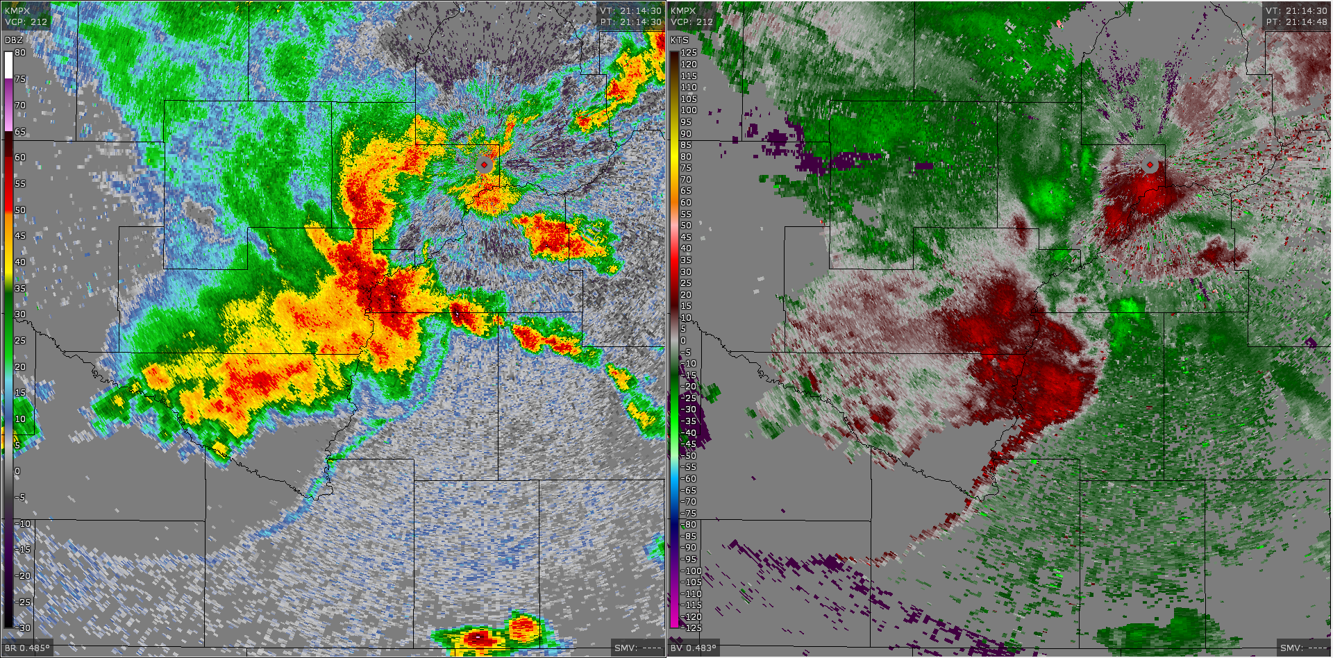
On June 04 2019 thunderstorms moved across the region and produced damaging wind and large hail. Some of the more significant damage occurred in Le Sueur and Scott Counties in central Minnesota. This damage can be traced back to a descending rear inflow jet which caused the gust front to bow out. The image to the right is at 11 hour loop of radar reflectivity. The warmer colors (orange, red, pink) shows where the rain and hail is located within the storm. Notice the bowing structure south of the Twin Cities as the storms approach the Minnesota/Wisconsin border. This is when the strongest winds were reported with this storm. |
Radar
Header
 |
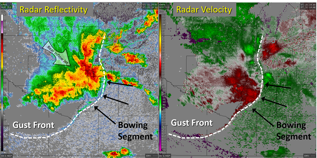 |
| Radar image at 4:15 PM showing the reflectivity on the left, and velocity on the right. | The same radar image, only annotated to show the bowing segment along the gust front. This was driven by the rear inflow jet, which can be identified by the lower reflectivity behind the line. Meanwhile the velocity images shows very little wind because the storms are moving across the radar beam. This makes strong wind more difficult to detect than if the storms were moving directly toward or away from the radar. |
Storm Reports
Here is the full list of storm reports from the Storm Prediction Center.

Below is a Public Information Statement with hail and wind gusts
NATIONAL WEATHER SERVICE TWIN CITIES/CHANHASSEN MN
256 AM CDT WED JUN 5 2019

...HAIL REPORTS...

LOCATION                     SIZE      TIME/DATE       LAT/LON

...MINNESOTA...

...CHIPPEWA COUNTY...
1 SW MONTEVIDEO              1.25 IN   0200 PM 06/04   44.94N/95.73W
MONTEVIDEO                   0.75 IN   0145 PM 06/04   44.95N/95.72W

...DAKOTA COUNTY...
2 W LAKEVILLE                1.00 IN   0446 PM 06/04   44.68N/93.29W

...LE SUEUR COUNTY...
4 NNW HEIDELBERG             1.00 IN   0415 PM 06/04   44.54N/93.67W

...MCLEOD COUNTY...
1 WSW SILVER LAKE            1.75 IN   0348 PM 06/04   44.90N/94.21W
2 W LESTER PRAIRIE           1.75 IN   0345 PM 06/04   44.88N/94.09W
2 NNW PLATO                  0.70 IN   0449 PM 06/04   44.80N/94.06W

...POPE COUNTY...
LOWRY                        0.75 IN   1225 PM 06/04   45.70N/95.52W
2 W LOWRY                    0.75 IN   1220 PM 06/04   45.70N/95.57W

...RAMSEY COUNTY...
SHOREVIEW                    0.70 IN   0400 PM 06/04   45.08N/93.13W

...SCOTT COUNTY...
3 NW NEW PRAGUE              1.75 IN   0425 PM 06/04   44.57N/93.62W
ELKO NEW MARKET              1.00 IN   0455 PM 06/04   44.57N/93.34W
1 NNE CREDIT RIVER           0.88 IN   0425 PM 06/04   44.69N/93.37W

...WRIGHT COUNTY...
3 SSE MONTICELLO             1.00 IN   0728 PM 06/04   45.27N/93.77W

...YELLOW MEDICINE COUNTY...
5 S GRANITE FALLS            1.00 IN   0453 PM 06/04   44.74N/95.54W
3 SSW GRANITE FALLS          1.00 IN   0430 PM 06/04   44.77N/95.55W

...HIGHEST WIND REPORTS...

LOCATION                     SPEED     TIME/DATE       LAT/LON

...MINNESOTA...

...CHIPPEWA COUNTY...
CLARA CITY 2WSW              63 MPH    0205 PM 06/04   44.95N/95.41W

...FREEBORN COUNTY...
1 W GENEVA                   60 MPH    0534 PM 06/04   43.82N/93.29W
2 SW GENEVA                  60 MPH    0531 PM 06/04   43.80N/93.30W

...LE SUEUR COUNTY...
3 ENE HENDERSON              85 MPH    0418 PM 06/04   44.54N/93.85W
4 NNW HEIDELBERG             85 MPH    0417 PM 06/04   44.54N/93.67W

...MCLEOD COUNTY...
1 SSW HUTCHINSON             59 MPH    0315 PM 06/04   44.87N/94.38W

...RENVILLE COUNTY...
1 S HECTOR                   58 MPH    0329 PM 06/04   44.73N/94.72W

...RICE COUNTY...
NORTHFIELD                   75 MPH    0450 PM 06/04   44.45N/93.17W
4 NW MORRISTOWN              60 MPH    0440 PM 06/04   44.25N/93.50W

...SCOTT COUNTY...
5 E JORDAN                   64 MPH    0434 PM 06/04   44.66N/93.52W

...SHERBURNE COUNTY...
ST. CLOUD AP                 55 MPH    0208 PM 06/04   45.55N/94.05W

...SIBLEY COUNTY...
1 N BELLE PLAINE             59 MPH    0415 PM 06/04   44.64N/93.77W

...STEARNS COUNTY...
2 NE KIMBALL                 58 MPH    0210 PM 06/04   45.34N/94.27W
SAUK CENTRE AP               48 MPH    1256 PM 06/04   45.70N/94.93W

OBSERVATIONS ARE COLLECTED FROM A VARIETY OF SOURCES WITH VARYING
EQUIPMENT AND EXPOSURES. WE THANK ALL VOLUNTEER WEATHER OBSERVERS
FOR THEIR DEDICATION. NOT ALL DATA LISTED ARE CONSIDERED OFFICIAL.
THERE WERE ADDITIONAL REPORTS OF THUNDERSTORM DAMAGE THAT ARE
NOT INCLUDED IN THIS SUMMARY.
 |
Media use of NWS Web News Stories is encouraged! Please acknowledge the NWS as the source of any news information accessed from this site. |
|

