Overview
|
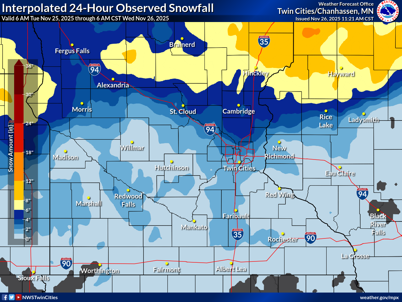
In late November, two winter storms moved across Minnesota and Wisconsin. |
 |
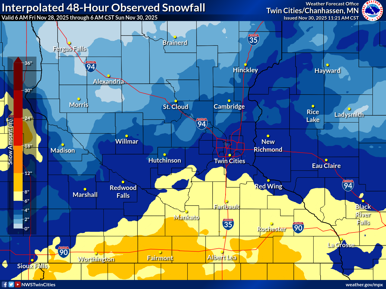 |
| Storm 1: Observed snowfall map from November 25, 2025. The heaviest snow from this event fell along and north of I-94. | Storm 2: Observed snowfall map from November 28-29, 2025. The heaviest snow from this event fell along and south of I-94. |
| Snowfall Reports from Storm 1, November 25, 2025 | Snowfall Reports from Storm 2, November 28-29, 2025 |
..TIME...   ...EVENT...      ...CITY LOCATION...     ...LAT.LON...
..DATE...   ....MAG....      ..COUNTY LOCATION..ST.. ...SOURCE....
            ..REMARKS..

0600 AM     Snow             2 SW Long Prairie       45.96N 94.89W
11/26/2025  M7.2 Inch        Todd               MN   CO-OP Observer
            CO-OP Observer station LNGM5 Long Prairie.

0700 AM     Snow             2 SW Oak Grove          45.31N 93.35W
11/26/2025  M5.5 Inch        Anoka              MN   Cocorahs
            Cocorahs station MN-AA-169 Oak Grove 2.7
            SSW.

0600 AM     Snow             2 E Alexandria          45.88N 95.34W
11/26/2025  M5.3 Inch        Douglas            MN   Cocorahs
            Cocorahs station MN-DS-41 Alexandria 1.6 E.

0700 AM     Snow             4 E Ham Lake            45.25N 93.16W
11/26/2025  M5.3 Inch        Anoka              MN   Cocorahs
            Cocorahs station MN-AA-31 Ham Lake 2E.

0645 AM     Snow             Shoreview               45.08N 93.14W
11/26/2025  M4.5 Inch        Ramsey             MN   Cocorahs
            Cocorahs station MN-RM-313 Shoreview 0.2 W.

0645 AM     Snow             1 SSE Chisago City      45.36N 92.88W
11/26/2025  M4.5 Inch        Chisago            MN   Cocorahs
            Cocorahs station MN-CG-70 Chisago City 1.6
            ENE.

0700 AM     Snow             4 ESE Grandy            45.62N 93.12W
11/26/2025  M4.5 Inch        Chisago            MN   Cocorahs
            Cocorahs station MN-CG-66 Stanchfield 4.7
            SE.

0700 AM     Snow             3 SE Nowthen            45.30N 93.43W
11/26/2025  M4.5 Inch        Anoka              MN   Cocorahs
            Cocorahs station MN-AA-76 Nowthen 2.9 SSE.
0700 AM     Snow             Brandon                 45.97N 95.60W
11/26/2025  M6.0 Inch        Douglas            MN   Cocorahs
            Cocorahs station MN-DS-50 Brandon 0.4 WNW.

0700 AM     Snow             2 NNE Brooklyn Park     45.13N 93.34W
11/26/2025  M5.0 Inch        Hennepin           MN   Cocorahs
            Cocorahs station MN-HN-379 Brooklyn Park 1.5
            NNE.

0700 AM     Snow             3 SE Orrock             45.41N 93.69W
11/26/2025  M3.5 Inch        Sherburne          MN   Cocorahs
            Cocorahs station MN-SH-10 Orrock 2SE.

0730 AM     Snow             1 W Stacy               45.40N 93.02W
11/26/2025  M3.5 Inch        Chisago            MN   Cocorahs
            Cocorahs station MN-CG-7 Stacy 1W.

0628 AM     Snow             2 SSW Cambridge         45.55N 93.24W
11/26/2025  M3.3 Inch        Isanti             MN   Cocorahs
            Cocorahs station MN-IS-28 Cambridge 1.3 SW.
|
..TIME...   ...EVENT...      ...CITY LOCATION...     ...LAT.LON...
..DATE...   ....MAG....      ..COUNTY LOCATION..ST.. ...SOURCE....
            ..REMARKS..

0700 AM     Snow             1 ESE Blue Earth        43.64N 94.09W
11/30/2025  M12.0 Inch       Faribault          MN   Cocorahs
            Cocorahs station MN-FT-5 Blue Earth 0.6 ESE.

1000 AM     Snow             1 S Fairmont            43.64N 94.46W
11/30/2025  M10.5 Inch       Martin             MN   Public
            Photo report on X. Event total.

0600 AM     Snow             1 WNW Winnebago         43.77N 94.19W
11/30/2025  M9.8 Inch        Faribault          MN   CO-OP Observer
            CO-OP Observer station WNNM5 Winnebago.

0700 AM     Snow             Ellendale               43.87N 93.30W
11/30/2025  M8.4 Inch        Steele             MN   Cocorahs
            Cocorahs station MN-SE-3 Ellendale 0.3 SW.

0700 AM     Snow             Northfield              44.45N 93.16W
11/30/2025  M8.0 Inch        Rice               MN   Cocorahs
            Cocorahs station MN-RC-78 Northfield 0.4
            SSW.

0700 AM     Snow             1 NNW New Prague        44.56N 93.58W
11/30/2025  M7.5 Inch        Scott              MN   Cocorahs
            Cocorahs station MN-SC-49 New Prague 1.0
            NNW.

0700 AM     Snow             2 NE Kasota             44.31N 93.95W
11/30/2025  M7.5 Inch        Le Sueur           MN   Cocorahs
            Cocorahs station MN-LS-32 Saint Peter 1.6
            SSE.

0700 AM     Snow             New Ulm                 44.31N 94.46W
11/30/2025  M7.5 Inch        Brown              MN   Cocorahs
            Cocorahs station MN-BW-17 New Ulm 0.5 E.

0800 AM     Snow             1 ENE Cannon Falls      44.51N 92.90W
11/30/2025  M7.4 Inch        Goodhue            MN   Cocorahs
            Cocorahs station MN-GH-28 Cannon Falls 0.5
            SE.

0700 AM     Snow             1 SW Albert Lea         43.64N 93.39W
11/30/2025  M7.0 Inch        Freeborn           MN   Cocorahs
            Cocorahs station MN-FN-5 Albert Lea 1WSW.

0700 AM     Snow             2 ESE Mankato           44.16N 93.95W
11/30/2025  M7.0 Inch        Blue Earth         MN   Cocorahs
            Cocorahs station MN-BU-23 Mankato 1ESE.

0700 AM     Snow             1 NNW New Prague        44.56N 93.58W
11/30/2025  M6.5 Inch        Scott              MN   Cocorahs
            Cocorahs station MN-SC-49 New Prague 1.0
            NNW.

0700 AM     Snow             2 N Rosemount           44.76N 93.13W
11/30/2025  M6.5 Inch        Dakota             MN   Cocorahs
            Cocorahs station MN-DK-11 Rosemount 3WNW.

0800 AM     Snow             1 ENE Victoria          44.87N 93.64W
11/30/2025  M6.2 Inch        Carver             MN   Cocorahs
            Cocorahs station MN-CV-103 Victoria 1.0 ENE.

0745 AM     Snow             1 N Prior Lake          44.72N 93.43W
11/30/2025  M6.1 Inch        Scott              MN   NWS Employee
            Event total.

0144 AM     Snow             3 NNE Eau Claire        44.85N 91.48W
11/30/2025  M5.8 Inch        Eau Claire         WI   Cocorahs
            Cocorahs station WI-EC-43 2 NNE Eau Claire.

0800 AM     Snow             1 E Hudson              44.98N 92.74W
11/30/2025  M5.6 Inch        St. Croix          WI   Cocorahs
            Cocorahs station WI-SC-65 1 E Hudson.

0703 AM     Snow             3 S River Falls         44.81N 92.63W
11/30/2025  M5.5 Inch        Pierce             WI   Cocorahs
            Cocorahs station WI-PC-49 River Falls 3.3 S.
            The period of the Snow event was 48 hours.

0643 AM     Snow             13 S Altoona            44.62N 91.48W
11/30/2025  M5.5 Inch        Eau Claire         WI   Cocorahs
            Cocorahs station WI-EC-28 Eleva 2.8 NNW.

0800 AM     Snow             2 SSW Lund              44.52N 92.22W
11/30/2025  M5.3 Inch        Pepin              WI   Cocorahs
            Cocorahs station WI-PP-2 Stockholm 2NE.
|
| Observed Wind Gusts from Storm 1, November 25, 2025 | Observed Wind Gusts from Storm 2, November 28-29, 2025 |
...HIGHEST WIND GUSTS NOV 25, 2025...

Location                     Speed     Time/Date       Provider
Fairmont AP                  54 MPH    1024 PM 11/25   AWOS
St. James AP                 54 MPH    0535 AM 11/26   AWOS
Madison AP                   53 MPH    0855 PM 11/25   AWOS
Eden Prairie AP              52 MPH    0815 AM 11/26   ASOS
Redwood Falls AP             52 MPH    1048 PM 11/25   ASOS
Morris AP                    51 MPH    0735 PM 11/25   AWOS
Olivia AP                    51 MPH    0415 AM 11/26   AWOS
Crystal AP                   48 MPH    1112 AM 11/26   ASOS
St. Paul Dwtn AP             48 MPH    0128 AM 11/26   ASOS
Canby AP                     48 MPH    0735 PM 11/25   AWOS
Mankato AP                   48 MPH    0141 AM 11/26   AWOS
Montevideo AP                48 MPH    1035 PM 11/25   AWOS
New Ulm AP                   48 MPH    0535 AM 11/26   AWOS
Eau Claire AP                47 MPH    1213 PM 11/26   ASOS
Minneapolis-St. Paul AP      47 MPH    1014 AM 11/26   ASOS
Granite Falls AP             46 MPH    0755 PM 11/25   AWOS
St. Cloud AP                 45 MPH    0956 AM 11/26   ASOS
Willmar AP                   45 MPH    0415 AM 11/26   AWOS
Lakeville AP                 45 MPH    0855 AM 11/26   AWOS
Alexandria MN ASOS           44 MPH    0736 PM 11/25   ASOS
Benson AP                    44 MPH    0655 PM 11/25   AWOS
Waseca AP                    43 MPH    0215 AM 11/26   AWOS
Albert Lea AP                43 MPH    0230 AM 11/26   AWOS
Menomonie AP                 43 MPH    0555 AM 11/26   AWOS
Owatonna AP                  43 MPH    0851 AM 11/26   AWOS
Stanton AP                   43 MPH    0957 AM 11/26   AWOS
Cambridge AP                 41 MPH    1219 AM 11/26   AWOS
Red Wing AP                  41 MPH    0335 AM 11/26   AWOS
New Richmond AP              41 MPH    1035 AM 11/26   AWOS
Glencoe AP                   40 MPH    0955 PM 11/25   AWOS
Hutchinson AP                40 MPH    0915 AM 11/26   AWOS
Cumberland AP                40 MPH    0315 AM 11/26   AWOS
Litchfield AP                39 MPH    0855 PM 11/25   AWOS
Maple Lake AP                39 MPH    1135 PM 11/25   AWOS
South St. Paul AP            39 MPH    1135 AM 11/26   AWOS
Lake Elmo AP                 38 MPH    0335 AM 11/26   AWOS
Glenwood AP                  38 MPH    0817 PM 11/25   AWOS
Tony AP                      38 MPH    0415 AM 11/26   AWOS
|
...HIGHEST WIND GUSTS FROM NOV 29, 2025...

Location                     Speed     Time/Date       Provider
Fairmont AP                  32 MPH    0446 AM 11/30   AWOS
St. James AP                 32 MPH    0255 AM 11/30   AWOS
Minneapolis-St. Paul AP      31 MPH    0154 PM 11/29   ASOS
Eden Prairie AP              30 MPH    0535 AM 11/30   ASOS
Redwood Falls AP             29 MPH    1153 PM 11/29   ASOS
New Ulm AP                   29 MPH    0235 AM 11/30   AWOS
Buffalo AP                   28 MPH    0215 AM 11/30   AWOS
Mankato AP                   28 MPH    1204 AM 11/30   AWOS
Morris AP                    28 MPH    0255 AM 11/30   AWOS
Owatonna AP                  28 MPH    0835 PM 11/29   AWOS
Waseca AP                    26 MPH    0315 AM 11/30   AWOS
Albert Lea AP                26 MPH    0255 AM 11/30   AWOS
Eau Claire AP                26 MPH    0156 PM 11/29   ASOS
Maple Lake AP                26 MPH    0135 AM 11/30   AWOS
Madison AP                   25 MPH    0415 AM 11/30   AWOS
Crystal AP                   25 MPH    0457 AM 11/30   ASOS
Rice Lake AP                 25 MPH    0535 AM 11/30   AWOS
St. Cloud AP                 25 MPH    1253 AM 11/30   ASOS
St. Paul Dwtn AP             25 MPH    0328 AM 11/30   ASOS
Cambridge AP                 24 MPH    0935 AM 11/30   AWOS
Canby AP                     24 MPH    1235 AM 11/30   AWOS
Glencoe AP                   24 MPH    0215 AM 11/30   AWOS
Hutchinson AP                24 MPH    0835 PM 11/29   AWOS
Lakeville AP                 24 MPH    0535 AM 11/30   AWOS
Montevideo AP                24 MPH    0715 AM 11/30   AWOS
Olivia AP                    24 MPH    0735 AM 11/30   AWOS
Tony AP                      24 MPH    1255 AM 11/30   AWOS
New Richmond AP              24 MPH    0555 AM 11/30   AWOS
Stanton AP                   24 MPH    0535 AM 11/30   AWOS
Benson AP                    23 MPH    0615 AM 11/30   AWOS
Faribault AP                 23 MPH    0635 AM 11/30   AWOS
Granite Falls AP             23 MPH    0815 AM 11/30   AWOS
Litchfield AP                23 MPH    0155 AM 11/30   AWOS
Princeton AP                 23 MPH    0248 AM 11/30   AWOS
Cumberland AP                23 MPH    0515 AM 11/30   AWOS
Alexandria MN ASOS           22 MPH    0653 AM 11/30   ASOS
Willmar AP                   22 MPH    1235 PM 11/29   AWOS
Sauk Centre AP               22 MPH    0535 AM 11/30   AWOS
Menomonie AP                 22 MPH    0955 AM 11/30   AWOS
Osceola AP                   22 MPH    0515 AM 11/30   AWOS
Rush City AP                 22 MPH    0355 AM 11/30   ASOS
South St. Paul AP            22 MPH    0615 AM 11/30   AWOS
Chetek AP                    22 MPH    0835 AM 11/30   AWOS
|
 |
Media use of NWS Web News Stories is encouraged! Please acknowledge the NWS as the source of any news information accessed from this site. |
|

