Proposed Partial County Alerting - Hennepin County
Public comments accepted through September 16, 2024
In addition to whole county alerting some NWS offices are looking to sub-divide the County by what we call Partial County Alerting (PCA). This will be most noticeable via alerts issued with the Emergency Alert System (EAS) and NOAA Weather Radio (NWR). Alerting via EAS and NWR are based on the Federal Information Processing Series (FIPS) and Specific Area Message Encoding (SAME), which tells the alert where to go.
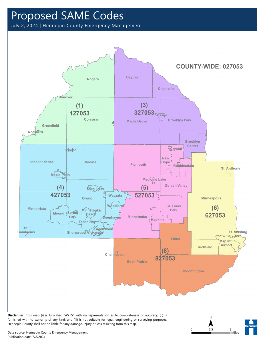
If PCA is adopted, in addition to the entire County alerting, residents will be separated into distinct geographical areas. This will be annotated by the leading digit of the SAME code. The SAME code is the FIPS codes plus a digit at the beginning. FIPS for Hennepin County is 27053 with the SAME code being 027053. FIPS codes that are Partial County Alerting will change the first zero (0) to a digit between one (1) and nine (9). See the maps linked on this page to find out what the leading digit changes to for your city, x27053, where x is a number between 1-9.
Note: PCA will NOT impact Wireless Emergency Alerts. If you choose to continue receiving alerts for the entire county via NOAA Weather Radio, no action is needed.
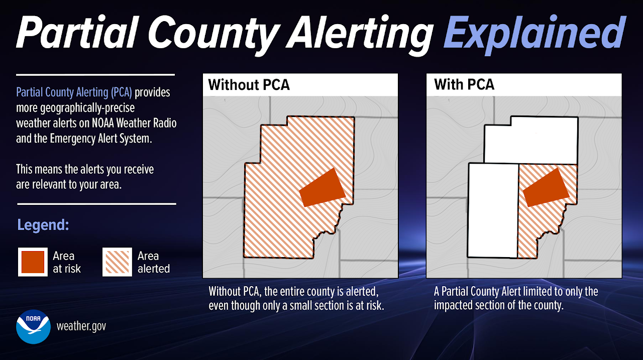
| PCA Explanation |
 |
To provide your comments, please email:
National Weather Service Twin Cities
E-mail: NWS Twin Cities
NWS Weather Forecast Office (WFO) Twin Cities, MN and Hennepin County Emergency Management are proposing a change in the dissemination of warnings via NOAA Weather Radio All Hazards (NWR) and the Emergency Alert System (EAS) for Hennepin County. This change would target the delivery of weather warnings to populations to a more targeted threat area and minimize or eliminate unnecessary delivery of weather and water warnings to residents located far from the threat area.
NWR listeners who wish to continue receiving SAME weather alerts for all Hennepin County partitions should make no changes and continue using SAME Code 027053.
NWR listeners who wish to receive SAME weather alerts specific to their local area should add the appropriate, partition-specific SAME Code and delete SAME Code 027053. If you live near a partition boundary, you may wish to program multiple SAME codes.
Note that if WFO Twin Cities issues a weather alert applicable to the entire county, you will continue to receive these alerts. You will also continue to receive all Civil Emergency Messages issued for Hennepin County.
| Proposed Hennepin County Partitions |
 |
To provide your comments, please email:
National Weather Service Twin Cities
E-mail: NWS Twin Cities
NOAA Weather Radio All Hazards (NWR) uses Specific Area Message Encoding (SAME) when the following warnings are issued by WFO Twin Cities:
Although NWS meteorologists specify latitude and longitude points (i.e., polygons) to identify the threat area, the warnings from Hennepin County are currently conveyed via NWR and the Emergency Alert System (EAS) to the whole county. This means that even if a very small part of Hennepin County is included in a warning, all of Hennepin County receives the warning via SAME. Because of Hennepin County's population is heavily weighted to the eastern half of the county, residents are unnecessarily receiving EAS and NWR notifications for warnings in areas located up to 30 miles from the actual threat area.
To address the issue of SAME and EAS over alerting for large counties when only a portion of the county is, in fact, affected, five WFOs (Duluth, Glasgow, Rapid City, Tucson, and Las Vegas) assigned partial county NWR and EAS codes to sections of large counties within their area of responsibility. This partitioning has worked very well for them for many years. By using the SAME partial county location codes, these WFOs have successfully issued warnings for predefined parts of a county, which substantially reduces the “False Alarm Area” and “listener fatigue” via NWR and EAS.
To provide your comments, please email:
National Weather Service Twin Cities
E-mail: NWS Twin Cities
To provide your comments, please email:
National Weather Service Twin Cities
E-mail: NWS Twin Cities