Overview
|
A hot and humid air mass settled across the region beginning Sunday, August 25 and lasting through Monday, August 26. On Monday afternoon, heat indices exceed 100 degrees in many locations. This warm, unstable air was followed by two rounds of severe weather over the next 12 hours. On Monday afternoon, thunderstorms developed across western Minnesota, and formed into a line producing wind damage across central and eastern Minnesota, and western Wisconsin. Later that night into Tuesday morning, another round of storms develop and produced wind damage in eastern Minnesota and western Wisconsin. |
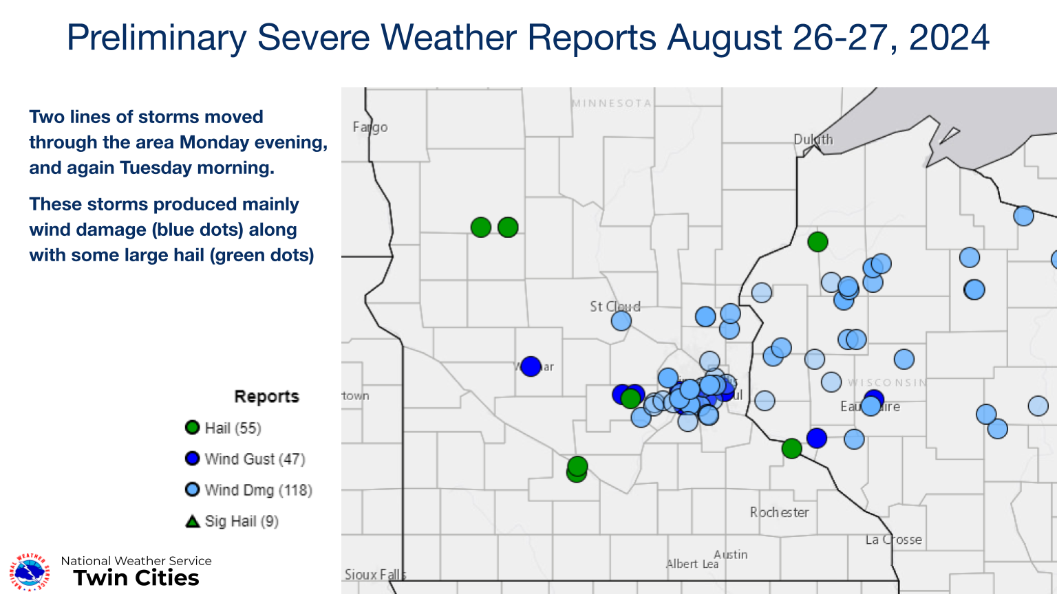 Preliminary storm reports from August 26-27, 2024. For the latest storm reports, please visit the Storm Prediction Center. |
Storm 1 Monday Evening
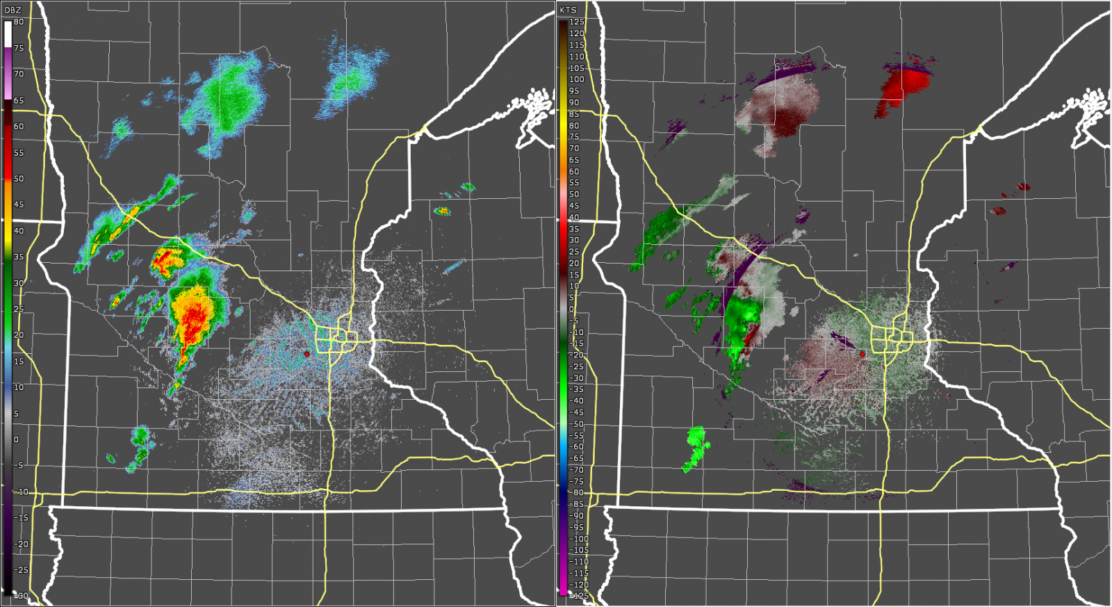
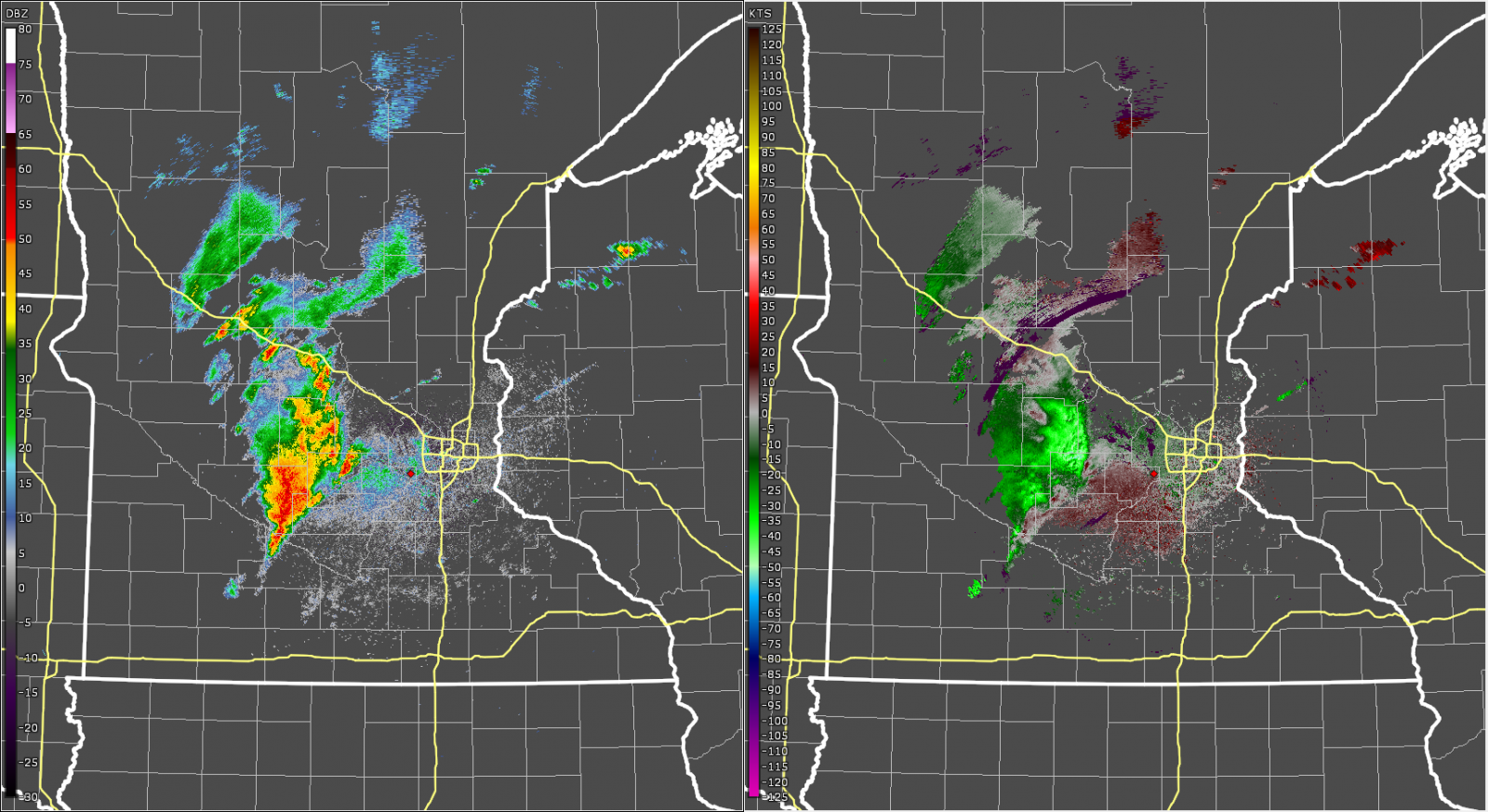
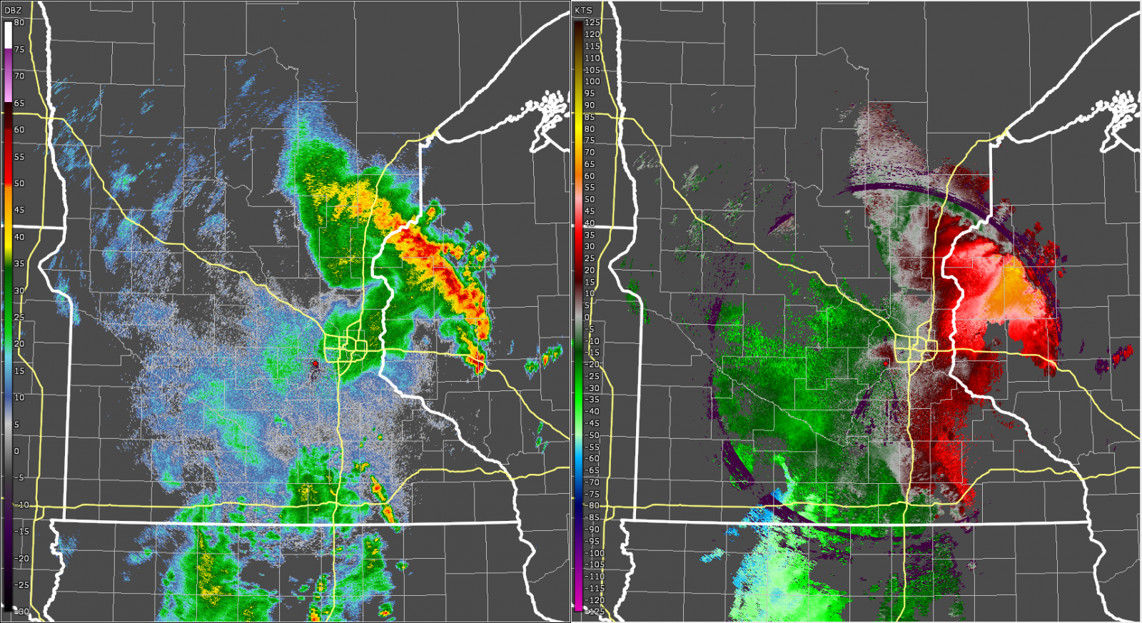
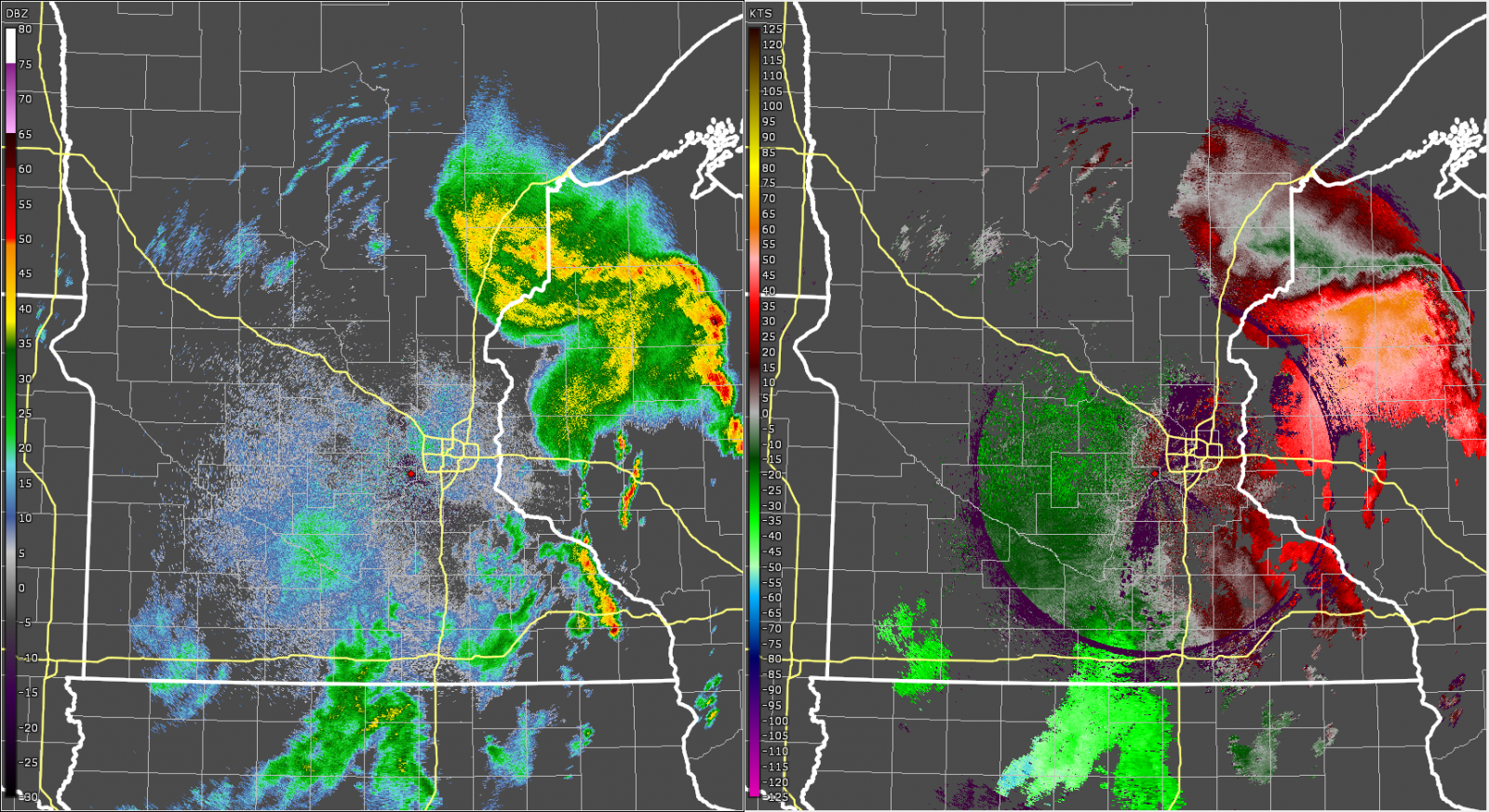
The pictures below show hourly radar images of the first storm as it moved across the region. This storm intensified between 6 and 7 pm as it approached the west Metro. A damage survey map is also included.
 |
 |
 |
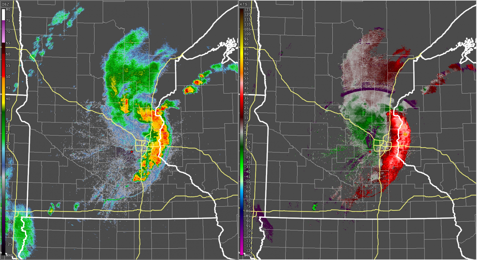
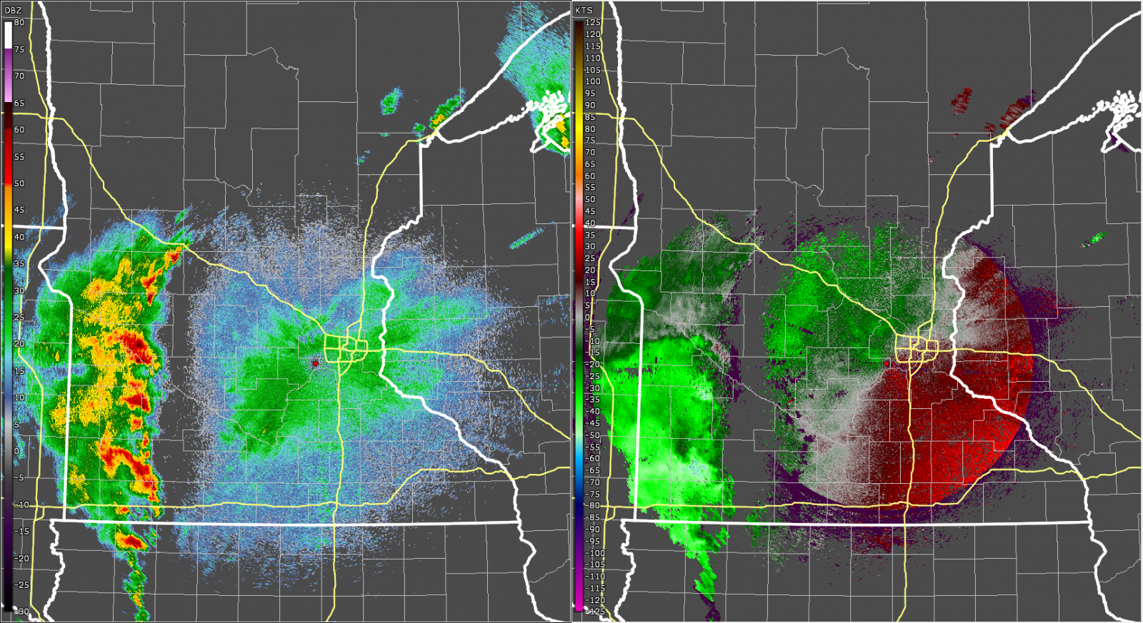
| Radar reflectivity (left) and velocity (right) at 5:00 pm on August 26, 2024. At this time, storms were developing across west central Minnesota | Radar reflectivity (left) and velocity (right) at 6:00 pm on August 26, 2024. At this time, storms continued across west central Minnesota, but started to develop a cold pool. | Radar reflectivity (left) and velocity (right) at 7:00 pm on August 26, 2024. At this time, the cold pool was well established, and the outflow boundary can be seen as a fine line in the reflectivity out ahead of the main convection. There are a few pockets of bright green that indicate higher velocity, and coincides with the widespread tree damage that was ongoing in the west metro. The Flying Cloud airport measured a 63 mph wind gust. |
 |
 |
 |
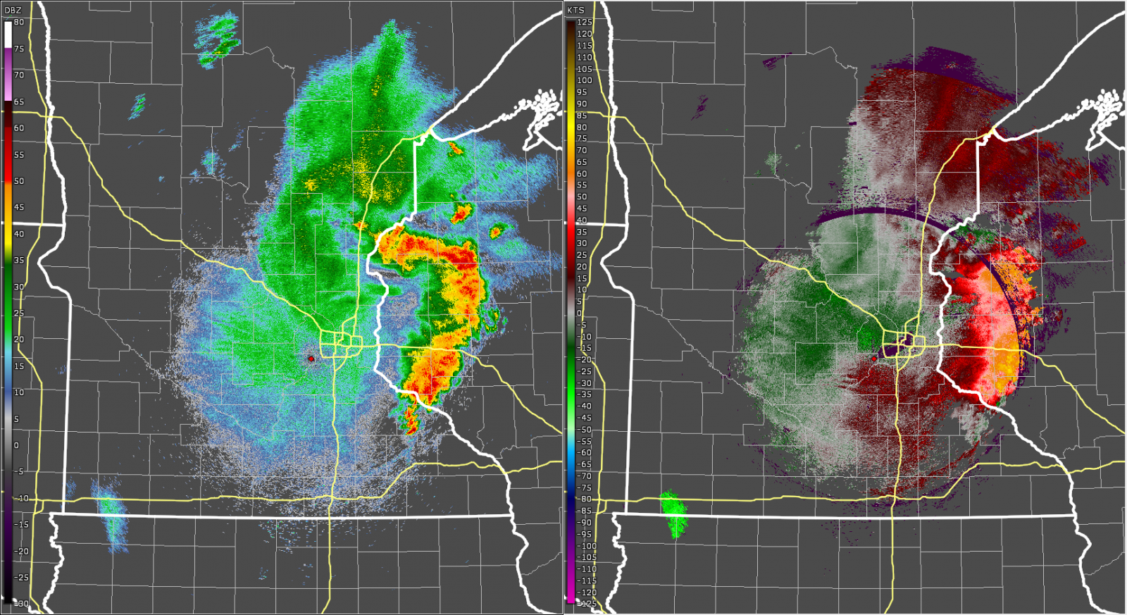
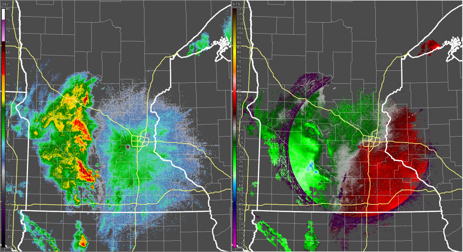
| Radar reflectivity (left) and velocity (right) at 8:00 pm on August 26, 2024. At this time, the transition to a bow echo was nearly complete. The strongest winds are shown in the brighter red colors, because these winds are moving away (from west to east) from the radar. | Radar reflectivity (left) and velocity (right) at 9:00 pm on August 26, 2024. At this time, the bow echo is mature with strong outbound winds evident in the velocity. However, keep in mind that as the storm moves away from the radar, the sampling elevation of the radar is higher above the ground and less likely to represent the observed winds at the surface. | Radar reflectivity (left) and velocity (right) at 10:00 pm on August 26, 2024. At this time, the storm is exciting the forecast area and moving into central Wisconsin. |
 |
||
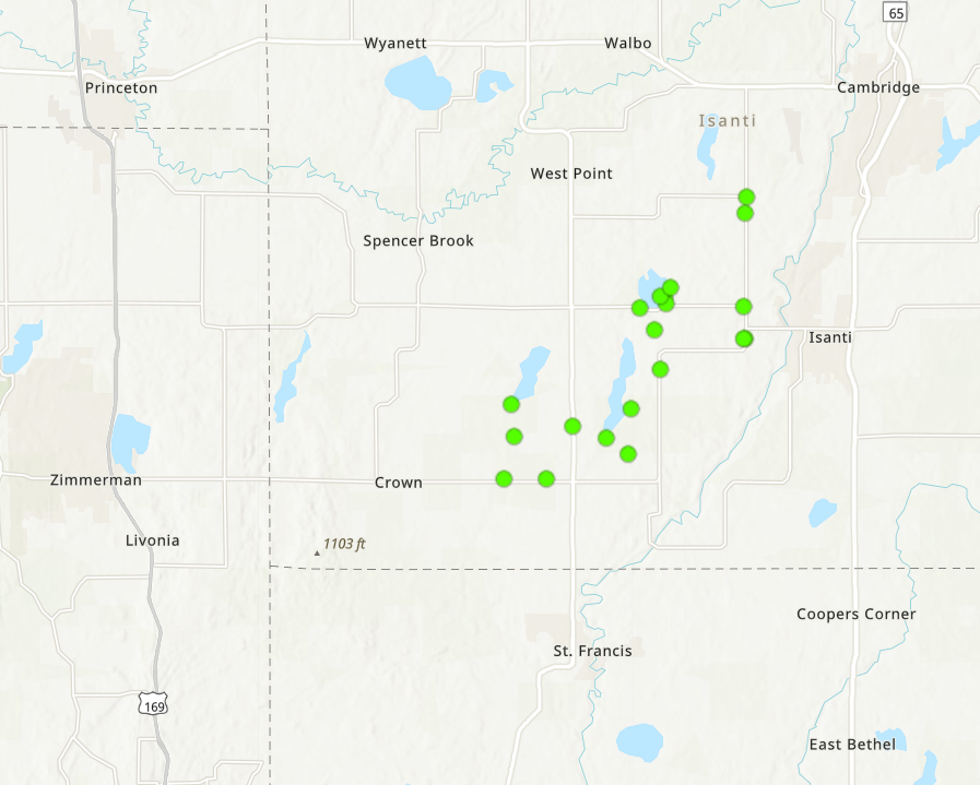
| Damage surveys were conducted in the southwestern quarter of Isanti County. It was determined that all of the damage was due to downbursts, with winds estimated at 75 to 85 mph. The green dots show just a sampling of where downburst damage was noted. Many hundreds of trees were uprooted or broken, some of which landed on houses, vehicles, and sheds. A few buildings had a portion of the roof torn off. All damage that was surveyed was blown to the northeast, sometimes to the east or north. |
Below is a summary of storm reports from the first round of storms
Monday that occurred Monday afternoon and evening. For the latest
information please see the Storm Prediction Center's reports page.

..TIME...   ...EVENT...      ...CITY LOCATION...     ...LAT.LON...
..DATE...   ....MAG....      ..COUNTY LOCATION..ST.. ...SOURCE....
            ..REMARKS..

1007 PM     Tstm Wnd Gst     2 ESE Porcupine         44.58N 92.07W
08/26/2024  M59 MPH          Pepin              WI   Mesonet

            Mesonet station TT569 Ganoe Hill.

0932 PM     Tstm Wnd Gst     4 NNE Eau Claire        44.87N 91.47W
08/26/2024  M63 MPH          Chippewa           WI   ASOS

            ASOS station KEAU Eau Claire AP.

0930 PM     Tstm Wnd Dmg     Cornell                 45.17N 91.15W
08/26/2024                   Chippewa           WI   Fire Dept/Rescue

            Reports of multiple trees down in Cornell.

0922 PM     Tstm Wnd Dmg     1 NE Eau Claire         44.82N 91.50W
08/26/2024                   Eau Claire         WI   Public

            Wind broke window on west side of home.

0904 PM     Tstm Wnd Dmg     3 S Wheeler             45.00N 91.91W
08/26/2024                   Dunn               WI   Trained Spotter

            Reports of numerous tree branches down
            throughout Dunn County. Time estimated from
            radar.

0900 PM     Tstm Wnd Dmg     Haugen                  45.61N 91.78W
08/26/2024                   Barron             WI   Trained Spotter

            Ten inch maple branch down with minor roof
            damage to house. Time is estimated.

0900 PM     Tstm Wnd Dmg     Haugen                  45.61N 91.78W
08/26/2024                   Barron             WI   Public


0900 PM     Tstm Wnd Dmg     Chetek                  45.32N 91.65W
08/26/2024                   Barron             WI   Fire Dept/Rescue

            Multiple trees and power lines down. Time
            estimated from radar.

0858 PM     Tstm Wnd Dmg     4 W Chetek              45.32N 91.74W
08/26/2024                   Barron             WI   Trained Spotter

            Delayed report of multiple large trees
            downed blocking roads. Time estimated from
            radar.

0856 PM     Hail             2 E Frontenac Station   44.50N 92.33W
08/26/2024  M1.00 Inch       Goodhue            MN   Public


0827 PM     Tstm Wnd Dmg     1 NE Chanhassen         44.88N 93.52W
08/26/2024                   Carver             MN   Trained Spotter

            6 inch oak branch down due to wind on the
            east side of Lotus Lake.

0800 PM     Tstm Wnd Dmg     Isanti                  45.49N 93.25W
08/26/2024                   Isanti             MN   Trained Spotter

            Large branch down, approximately 10-11
            inches in diameter at Whiskey Road and S.
            Brookview Lane.

0755 PM     Tstm Wnd Gst     Osceola                 45.32N 92.70W
08/26/2024  M55 MPH          Polk               WI   AWOS

            AWOS station KOEO Osceola AP.

0754 PM     Rain             1 ENE Maple Plain       45.01N 93.65W
08/26/2024  M0.70 Inch       Hennepin           MN   Trained Spotter

            Rainfall occurred over one hour.

0753 PM     Tstm Wnd Gst     2 ESE St. Paul          44.93N 93.05W
08/26/2024  M56 MPH          Ramsey             MN   ASOS

            ASOS station KSTP St. Paul Dwtn AP.

0752 PM     Tstm Wnd Gst     2 E Richfield           44.88N 93.23W
08/26/2024  M55 MPH          Hennepin           MN   ASOS

            ASOS station KMSP Minneapolis-St. Paul AP.

0745 PM     Tstm Wnd Dmg     North Branch            45.51N 92.98W
08/26/2024                   Chisago            MN   Law Enforcement

            Multiple trees down & widespread power
            outages in town. Time estimated from radar.

0740 PM     Tstm Wnd Dmg     Stacy                   45.40N 92.99W
08/26/2024                   Chisago            MN   Law Enforcement

            Multiple trees down & widespread power
            outages in town. Time estimated from radar.

0737 PM     Tstm Wnd Dmg     Maplewood               44.99N 93.02W
08/26/2024                   Ramsey             MN   Trained Spotter

            Delayed report of multiple downed tree
            branches with diameter up to 8 inches. Time
            estimated from radar.

0735 PM     Tstm Wnd Gst     1 N St. Paul            44.97N 93.09W
08/26/2024  M60 MPH          Ramsey             MN   Mesonet

            Mesonet station MN089 I-35e - Cayuga St
            Bridge Mp 46.

0730 PM     Tstm Wnd Dmg     2 SE Eden Prairie       44.83N 93.41W
08/26/2024                   Hennepin           MN   Public

            High winds blew large trampoline into
            neighbors house and broke.

0730 PM     Tstm Wnd Dmg     Isanti                  45.49N 93.25W
08/26/2024                   Isanti             MN   Trained Spotter

            Delayed report of multiple large trees down
            throughout Isanti. Time estimated from
            radar.

0725 PM     Tstm Wnd Dmg     1 N Roseville           45.03N 93.15W
08/26/2024                   Ramsey             MN   Public

            Large tree split in half.

0725 PM     Tstm Wnd Dmg     2 SSW Minneapolis       44.96N 93.27W
08/26/2024                   Hennepin           MN   Trained Spotter

            Delayed report via X. Large tree 23.75
            inches in diameter snapped at base near
            Minneapolis College of Art and Design. Time
            estimated from radar.

0723 PM     Tstm Wnd Gst     Savage                  44.76N 93.36W
08/26/2024  M69 MPH          Scott              MN   Trained Spotter

            Measured at Savage Community Park.

0720 PM     Tstm Wnd Dmg     Bloomington             44.82N 93.30W
08/26/2024                   Hennepin           MN   Trained Spotter

            Delayed report of multiple large trees down
            throughout Bloomington. Time estimated from
            radar.

0720 PM     Tstm Wnd Dmg     1 SSW Mendota           44.87N 93.17W
08/26/2024                   Dakota             MN   Trained Spotter

            Large pine tree uprooted and leaning on
            power lines.

0715 PM     Tstm Wnd Dmg     1 SSW Richfield         44.87N 93.29W
08/26/2024                   Hennepin           MN   Amateur Radio

            6 to 12 inch diameter branches down from
            healthy tree. Time estimated from radar.

0715 PM     Tstm Wnd Dmg     5 N St. Francis         45.45N 93.37W
08/26/2024                   Isanti             MN   Amateur Radio

            Numerous trees down in a narrow path toward
            the east or northeast. Damage type yet to be
            investigated.

0710 PM     Tstm Wnd Dmg     1 N Eden Prairie        44.86N 93.44W
08/26/2024                   Hennepin           MN   Public

            Delayed report, time estimated from radar.
            Several reports of trees down, and a street
            light down.

0710 PM     Tstm Wnd Dmg     1 NW Eden Prairie       44.86N 93.46W
08/26/2024                   Hennepin           MN   Trained Spotter

            Delayed report of downed power lines and
            numerous large trees. Time estimated from
            radar.

0710 PM     Tstm Wnd Dmg     1 ESE Deephaven         44.92N 93.51W
08/26/2024                   Hennepin           MN   Public

            Report via X. Multiple trees down and
            numerous power outages. Time estimated from
            radar.

0709 PM     Tstm Wnd Gst     2 SW Eden Prairie       44.83N 93.47W
08/26/2024  M63 MPH          Hennepin           MN   ASOS

            ASOS station KFCM Eden Prairie AP.

0705 PM     Tstm Wnd Dmg     3 NW Eden Prairie       44.88N 93.47W
08/26/2024                   Hennepin           MN   Trained Spotter

            8 inch diameter tree down on Woodland Drive
            in Eden Prairie.

0705 PM     Tstm Wnd Dmg     2 SW Zimmerman          45.42N 93.63W
08/26/2024                   Sherburne          MN   Public

            Three trees were downed.

0705 PM     Tstm Wnd Dmg     3 WSW Chanhassen        44.85N 93.59W
08/26/2024                   Carver             MN   NWS Employee

            Multiple large tree branches down.

0700 PM     Tstm Wnd Gst     3 W Anoka               45.20N 93.44W
08/26/2024  M62 MPH          Hennepin           MN   Broadcast Media

            Measured by meteorologist.

0700 PM     Tstm Wnd Dmg     1 WSW Victoria          44.86N 93.69W
08/26/2024                   Carver             MN   Public

            Large tree down.

0655 PM     Tstm Wnd Gst     2 ESE Carver            44.75N 93.58W
08/26/2024  M54 MPH          Scott              MN   Trained Spotter

            Multiple readings of 45 to 52 mph for three
            minutes after the 54 mph. Several small
            branches down.

0655 PM     Tstm Wnd Dmg     2 S Waconia             44.82N 93.79W
08/26/2024                   Carver             MN   Public

            Large tree branches down.

0652 PM     Tstm Wnd Dmg     1 E Waconia             44.85N 93.78W
08/26/2024                   Carver             MN   NWS Employee

            Report of power outages and a large tree
            down. Time estimated from radar.

0645 PM     Tstm Wnd Gst     2 NNW New Germany       44.91N 93.99W
08/26/2024  M59 MPH          Carver             MN   Mesonet

            Mesonet station MN022 T.h.7 - New Germany -
            Mp 161.

0640 PM     Tstm Wnd Dmg     2 S Loretto             45.03N 93.64W
08/26/2024                   Hennepin           MN   Public

            Very large oak tree down.

0635 PM     Funnel Cloud     2 N Nerstrand           44.37N 93.06W
08/26/2024                   Rice               MN   Trained Spotter

            Multiple reports with photos. No precip on
            radar anywhere nearby. Funnels looked to be
            quite high off the ground.

0635 PM     Tstm Wnd Dmg     2 ENE Hamburg           44.74N 93.93W
08/26/2024                   Carver             MN   Public

            Trees and power lines down. Time estimated
            from radar.

0635 PM     Tstm Wnd Gst     2 W Plato               44.77N 94.08W
08/26/2024  M53 MPH          McLeod             MN   AWOS

            AWOS station KGYL Glencoe AP.

0632 PM     Hail             3 N Essig               44.37N 94.60W
08/26/2024  M1.25 Inch       Brown              MN   Broadcast Media

            Time estimated based on radar.

0630 PM     Hail             Essig                   44.32N 94.61W
08/26/2024  M1.25 Inch       Brown              MN   Public

            Picture via Facebook.

0630 PM     Hail             Lester Prairie          44.88N 94.04W
08/26/2024  M1.75 Inch       McLeod             MN   Trained Spotter


0628 PM     Tstm Wnd Dmg     3 WNW Clearwater        45.43N 94.11W
08/26/2024                   Stearns            MN   Trained Spotter

            Numerous large trees snapped or uprooted in
            a 0.5 mile radius of Lynden Township Hall at
            the the intersection of County Road 44 and
            County Road 143. Time Estimated via Radar.

0628 PM     Tstm Wnd Dmg     2 SE St. Augusta        45.46N 94.13W
08/26/2024                   Stearns            MN   NWS Employee

            Delayed report, time estimated from radar.
            Several trees down along I-94 between mile
            marker 177 and 174.

0625 PM     Funnel Cloud     5 NNE Essig             44.39N 94.58W
08/26/2024                   Nicollet           MN   Trained Spotter

            Funnel cloud report via spotter network.
            Time estimated from radar.

0618 PM     Tstm Wnd Gst     4 E Silver Lake         44.91N 94.12W
08/26/2024  M65 MPH          McLeod             MN   Mesonet

            Mesonet station MN002 T.h.7 - Silver Lake -
            Mp 155.

0600 PM     Tstm Wnd Dmg     1 WSW Dassel            45.08N 94.32W
08/26/2024                   Meeker             MN   Law Enforcement

            Tree down across road. Time estimated.

0555 PM     Tstm Wnd Dmg     3 ENE Forest City       45.22N 94.40W
08/26/2024                   Meeker             MN   Law Enforcement

            Two trees down across roads. Time estimated.

0440 PM     Tstm Wnd Gst     2 WSW Willmar           45.12N 95.09W
08/26/2024  M62 MPH          Kandiyohi          MN   AWOS

            REPORTED AT WILLMAR, WILLMAR MUNICIPAL
            AIRPORT-JOHN L RICE FIELD.

0410 PM     Funnel Cloud     1 SSE Kerkhoven         45.18N 95.31W
08/26/2024                   Swift              MN   Trained Spotter

            Report via X with photo attached. Time
            estimated from radar.
Storm 2 Tuesday Morning
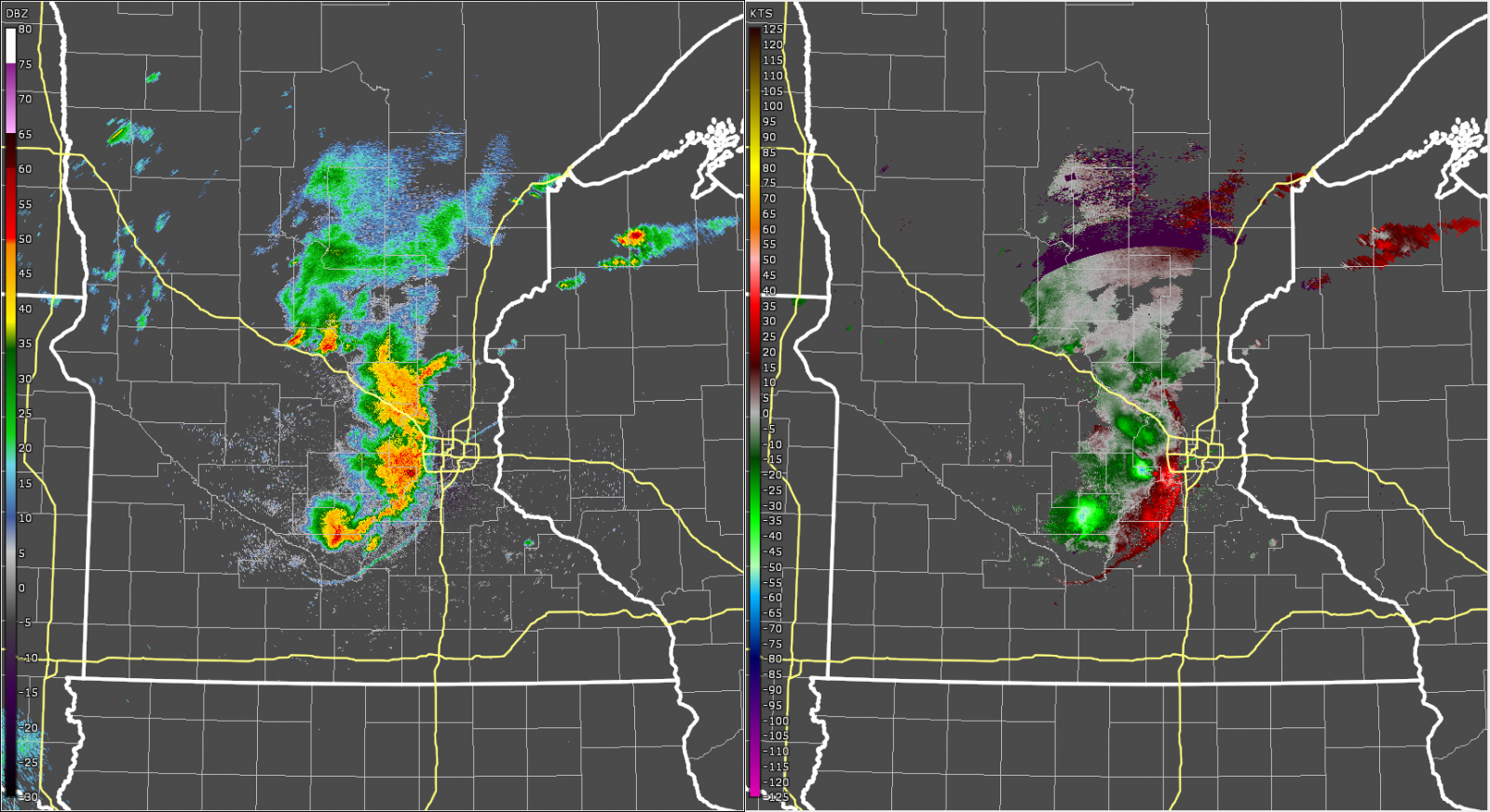
The pictures below show hourly radar images of the second storm as it moved across the region. This storm strengthened around 5 am as it approached the I-35 corridor.
 |
 |
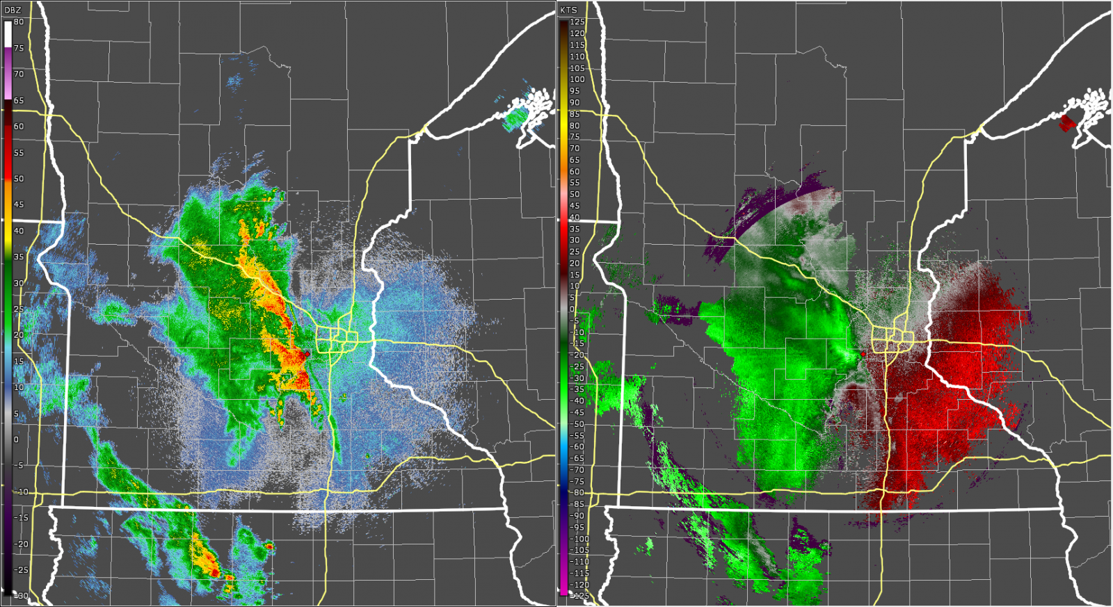 |
| Radar reflectivity (left) and velocity (right) at 3:00 am on August 27, 2024. At this time there was a broken line of storms across southwest Minnesota. These storms were not producing severe weather. | Radar reflectivity (left) and velocity (right) at 4:00 am on August 27, 2024. AT this time, there were two distinct areas of stronger convection shown by the higher reflectivity (red colors) on the left. | Radar reflectivity (left) and velocity (right) at 5:00 am on August 27, 2024. At this time, the storms had formed into a line, and were moving northeast at 45 mph. |
 |
 |
 |
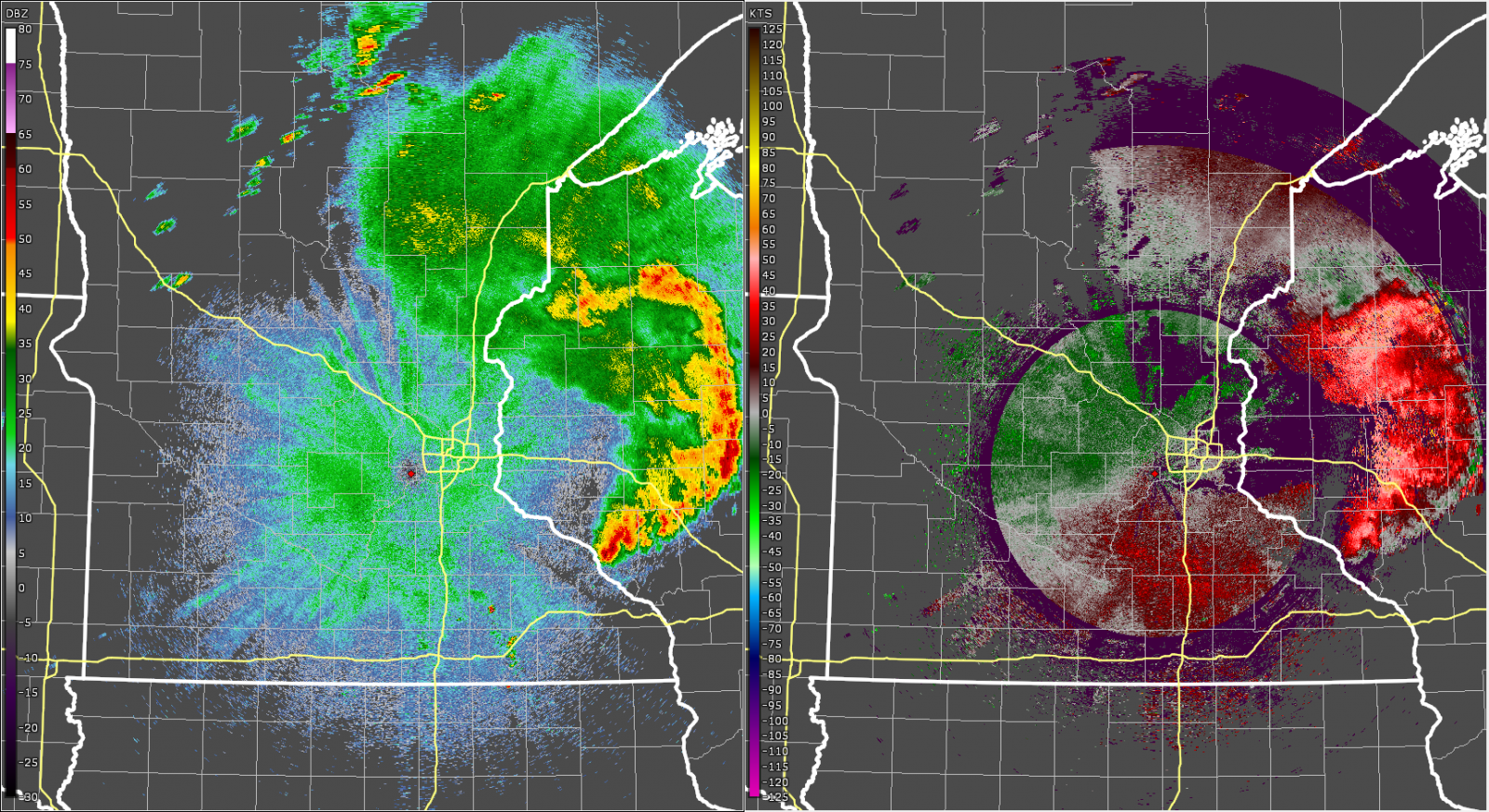
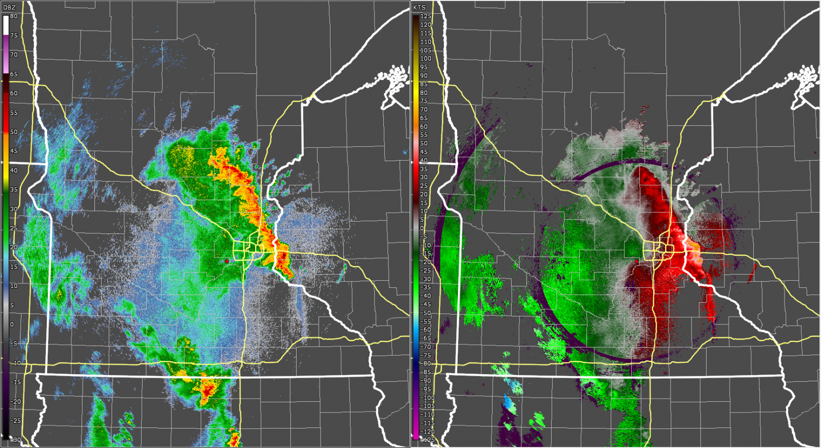
| Radar reflectivity (left) and velocity (right) at 6:00 am on August 27, 2024. At this time, storms had produced wind damage across the metro. The MSP airport measured a 61 mph wind gust, and the St Paul airport measured a 64 mph wind gust. | Radar reflectivity (left) and velocity (right) at 7:00 am on August 27, 2024. At this time, the storm continued to produce wind damage as it moved into northwest Wisconsin early Tuesday morning. | Radar reflectivity (left) and velocity (right) at 8:00 am on August 27, 2024. At this time the storm had bowed out, and a rear inflow jet was evident in both the reflectivity and velocity. |
Below is a summary of storm reports from the second round of storms
that occurred Monday night into Tuesday morning. For the latest
information please see the Storm Prediction Center's reports page.

..TIME...   ...EVENT...      ...CITY LOCATION...     ...LAT.LON...
..DATE...   ....MAG....      ..COUNTY LOCATION..ST.. ...SOURCE....
            ..REMARKS..

0628 AM     Tstm Wnd Dmg     5 SSE Reeve             45.17N 92.09W
08/27/2024                   Dunn               WI   Law Enforcement

            6 inch diameter tree down and a larger tree
            snapped at the base.

0627 AM     Tstm Wnd Dmg     5 SW Amery              45.26N 92.44W
08/27/2024                   Polk               WI   Public

            8 to 9 inch diameter trees snapped.

0618 AM     Tstm Wnd Dmg     Star Prairie            45.20N 92.53W
08/27/2024                   St. Croix          WI   Public

            2ft diameter trees uprooted.

0554 AM     Tstm Wnd Dmg     River Falls             44.86N 92.62W
08/27/2024                   Pierce             WI   Trained Spotter

            Large tree snapped at trunk. Video sent via
            Twitter.

0550 AM     Tstm Wnd Dmg     2 NE Lake Elmo          45.02N 92.87W
08/27/2024                   Washington         MN   Public

            Multiple medium-sized live trees snapped,
            some uprooted. Diameter approximately 5-7
            inches. Many branches down. Time estimated.

0547 AM     Tstm Wnd Dmg     1 ESE Blaine            45.16N 93.20W
08/27/2024                   Anoka              MN   Trained Spotter

            Tree down and several large branches down.

0542 AM     Tstm Wnd Gst     2 ESE St. Paul          44.93N 93.05W
08/27/2024  M64 MPH          Ramsey             MN   ASOS

            ASOS station KSTP St. Paul Dwtn AP.

0539 AM     Tstm Wnd Dmg     1 SSW St. Paul          44.94N 93.10W
08/27/2024                   Ramsey             MN   Emergency Mngr

            A branch with a three foot diameter was
            blown down at Harriet Island.

0538 AM     Tstm Wnd Gst     2 ESE St. Paul          44.93N 93.05W
08/27/2024  M64 MPH          Ramsey             MN   ASOS

            ASOS station KSTP St. Paul Dwtn AP.

0535 AM     Tstm Wnd Dmg     1 SW Falcon Heights     44.98N 93.20W
08/27/2024                   Ramsey             MN   Public


0533 AM     Tstm Wnd Dmg     2 NW St. Paul           44.98N 93.12W
08/27/2024                   Ramsey             MN   Amateur Radio

            Trees downed - 12 inches in diameter.

0532 AM     Tstm Wnd Dmg     1 SSE Roseville         45.00N 93.14W
08/27/2024                   Ramsey             MN   Emergency Mngr

            Trees fell on two houses in the
            neighborhood, and one house had major
            damage. Two roads in the neighborhood were
            blocked by fallen trees.

0532 AM     Tstm Wnd Dmg     2 ESE Falcon Heights    44.98N 93.14W
08/27/2024                   Ramsey             MN   Public

            Delayed report, time estimated from radar.
            Numerous large trees down and blocking roads
            in Como Park area.

0532 AM     Tstm Wnd Dmg     1 SSE Falcon Heights    44.98N 93.17W
08/27/2024                   Ramsey             MN   Public

            Large uprooted tree in Minnesota State Fair.
            Photo sent via Twitter.

0528 AM     Tstm Wnd Gst     2 E Richfield           44.88N 93.23W
08/27/2024  M61 MPH          Hennepin           MN   ASOS

            ASOS station KMSP Minneapolis-St. Paul AP.

0527 AM     Tstm Wnd Gst     1 ESE Richfield         44.87N 93.26W
08/27/2024  M60 MPH          Hennepin           MN   Trained Spotter

            Measured by non-NWS meteorologist.

0526 AM     Tstm Wnd Dmg     1 N Apple Valley        44.74N 93.21W
08/27/2024                   Dakota             MN   Amateur Radio

            Numerous trees down, including on a house
            and truck.

0526 AM     Tstm Wnd Dmg     2 N Apple Valley        44.75N 93.21W
08/27/2024                   Dakota             MN   Trained Spotter

            Large uprooted oak tree. Photo sent via
            Twitter.

0524 AM     Tstm Wnd Dmg     1 N Apple Valley        44.75N 93.21W
08/27/2024                   Dakota             MN   Trained Spotter

            Large tree blown over at the root ball and
            several Large 3+ tree branches down. Photos
            sent via Twitter.

0524 AM     Tstm Wnd Dmg     2 N Apple Valley        44.75N 93.21W
08/27/2024                   Dakota             MN   Trained Spotter

            Large tree snapped at base. Photo sent via
            Twitter.

0524 AM     Tstm Wnd Dmg     1 N Apple Valley        44.75N 93.21W
08/27/2024                   Dakota             MN   Public

            Several large 3 inch plus tree branches
            down. Power lines also down.

0524 AM     Tstm Wnd Dmg     2 NNW Apple Valley      44.76N 93.22W
08/27/2024                   Dakota             MN   Trained Spotter

            Large tree snapped at the base. Photo sent
            via Twitter.

0515 AM     Tstm Wnd Gst     Deephaven               44.93N 93.52W
08/27/2024  M59 MPH          Hennepin           MN   Mesonet


0514 AM     Tstm Wnd Dmg     Prior Lake              44.71N 93.43W
08/27/2024                   Scott              MN   Public

            Large tree branches down in homeowners yard.

0514 AM     Tstm Wnd Gst     2 SW Eden Prairie       44.83N 93.47W
08/27/2024  M61 MPH          Hennepin           MN   ASOS

            ASOS station KFCM Eden Prairie AP.

0500 AM     Tstm Wnd Dmg     2 W St. Louis Park      44.95N 93.41W
08/27/2024                   Hennepin           MN   Trained Spotter

            Multiple trees over 12 inches in diameter
            were uprooted with the morning round of
            storms. Many branches of varying sizes,
            construction signs, and outdoor items strewn
            about, some for some distance.

0255 AM     Tstm Wnd Gst     4 S Granite Falls       44.75N 95.55W
08/27/2024  M53 MPH          Yellow Medicine    MN   AWOS

            AWOS station KGDB Granite Falls AP.
Extreme Heat
Public Information Statement
National Weather Service Twin Cities/Chanhassen MN
1138 PM CDT Mon Aug 26 2024

...MAXIMUM HEAT INDEX REPORTS FROM MONDAY...

Location                     Heat Idx. Time/Date       Provider
Albert Lea AP                114 F     0235 PM 08/26   AWOS
Carver 3S                    113 F     0249 PM 08/26   RAWS
New Ulm                      113 F     0422 PM 08/26   RAWS
Augusta 1NW                  112 F     0305 PM 08/26   RAWS
Waseca AP                    111 F     0415 PM 08/26   AWOS
Mankato AP                   111 F     0256 PM 08/26   AWOS
Owatonna AP                  111 F     0453 PM 08/26   AWOS
Ganoe Hill                   111 F     0407 PM 08/26   RAWS
Faribault AP                 110 F     0535 PM 08/26   AWOS
Eden Prairie AP              110 F     0353 PM 08/26   ASOS
Fairmont AP                  110 F     0456 PM 08/26   AWOS
Princeton AP                 110 F     0355 PM 08/26   AWOS
Stanton AP                   110 F     0356 PM 08/26   AWOS
Ladysmith 2SW                110 F     0405 PM 08/26   RAWS
Willmar AP                   109 F     0215 PM 08/26   AWOS
Buffalo AP                   109 F     0355 PM 08/26   AWOS
Granite Falls AP             109 F     0255 PM 08/26   AWOS
Glencoe AP                   109 F     0415 PM 08/26   AWOS
Osceola AP                   109 F     0335 PM 08/26   AWOS
Menomonie AP                 108 F     0155 PM 08/26   AWOS
Lakeville AP                 108 F     0515 PM 08/26   AWOS
Crystal AP                   107 F     0253 PM 08/26   ASOS
Red Wing AP                  107 F     0455 PM 08/26   AWOS
St. Paul Dwtn AP             107 F     0353 PM 08/26   ASOS
Wyoming 6WSW                 106 F     0406 PM 08/26   RAWS
Santiago 3E                  106 F     0320 PM 08/26   RAWS
Blaine AP                    106 F     1155 AM 08/26   AWOS
Benson AP                    106 F     0215 PM 08/26   AWOS
Eau Claire AP                106 F     0356 PM 08/26   ASOS
Montevideo AP                106 F     0255 PM 08/26   AWOS
South St. Paul AP            106 F     0435 PM 08/26   AWOS
St. Cloud AP                 106 F     0353 PM 08/26   ASOS
New Ulm AP                   106 F     0555 PM 08/26   AWOS
Chetek AP                    106 F     1255 PM 08/26   AWOS
Litchfield 3S                106 F     0311 PM 08/26   RAWS
1 W Becker                   105 F     0255 PM 08/26   NDAWN
Redwood Falls AP             105 F     0353 PM 08/26   ASOS
Star Prairie                 105 F     0408 PM 08/26   RAWS
Mora 1ENE                    103 F     0408 PM 08/26   RAWS
Lake Elmo AP                 103 F     0515 PM 08/26   AWOS
Appleton AP                  103 F     0153 PM 08/26   AWOS
Hutchinson AP                103 F     0355 PM 08/26   AWOS
Litchfield AP                103 F     0155 PM 08/26   AWOS
Maple Lake AP                103 F     0235 PM 08/26   AWOS
Minneapolis-St. Paul AP      103 F     0717 PM 08/26   ASOS
Olivia AP                    103 F     0416 PM 08/26   AWOS
Paynesville AP               103 F     0216 PM 08/26   AWOS
New Richmond AP              103 F     0130 PM 08/26   AWOS
Cumberland AP                103 F     0355 PM 08/26   AWOS
Cambridge AP                 102 F     0415 PM 08/26   AWOS
Tony AP                      102 F     0235 PM 08/26   AWOS
Rice Lake AP                 102 F     0435 PM 08/26   AWOS
Camp Ripley                  101 F     0255 PM 08/26   AWOS
5 WSW Genola                 100 F     0345 PM 08/26   NDAWN
2 SE Royalton                100 F     0330 PM 08/26   NDAWN
Glenwood AP                  100 F     0215 PM 08/26   AWOS
Mora AP                      100 F     0115 PM 08/26   AWOS
Little Falls 2SSE            100 F     1207 PM 08/26   RAWS

Observations are collected from a variety of sources with varying
equipment and exposures. We thank all volunteer weather observers
for their dedication. Not all data listed are considered official.
 |
Media use of NWS Web News Stories is encouraged! Please acknowledge the NWS as the source of any news information accessed from this site. |
|

