Scattered severe thunderstorms capable of damaging wind gusts and some hail are expected this afternoon and evening from the Upper Ohio River Valley into the Northeast, and from the Appalachians into the Mid-Atlantic States. Excessive rainfall from heavy thunderstorms may produce areas of flash flooding from southern New Mexico into the western and northern Gulf Coast into Wednesday. Read More >
Overview
|
**Preliminary information as of July 14, 2024.** Multiple rounds of thunderstorms led to widespread wind and hail damage across parts of Minnesota and Wisconsin on July 13 into the morning of July 14. Scattered clusters of storms resulted in large hail over portions of east-central Minnesota during the afternoon on July 13. One storm produced a brief tornado in Rice County. A line of storms then developed over northwestern Minnesota during the evening and travelled southeast across central Minnesota throughout the night. This line led to numerous reports of hail and wind damage before it weakened as it moved into Wisconsin. An unusually warm and humid air mass resulted in heat index values greater than 100F across portions of southern and western Minnesota during the afternoon and evening of July 13. The combination of several thunderstorms and persistent cloud cover kept heat index values in the low to mid 80s further east. |
.png) Map of severe storm reports on July 13 and 14. The most up to date list of reports can be found here. |
Tornadoes
|
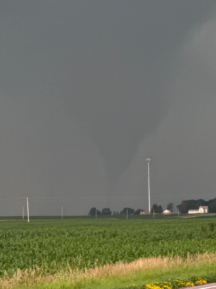
Tornado - Medford, MN
|
||||||
|
||||||
Wind & Hail:
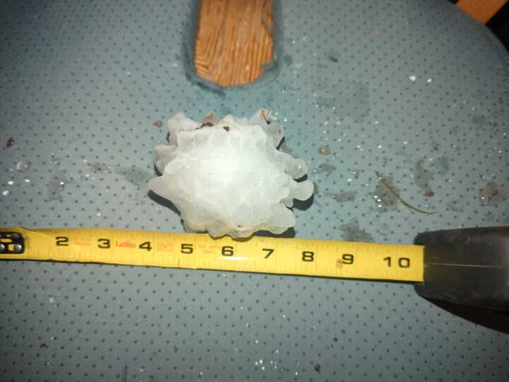
Widespread reports of wind damage and large hail occurred with the several rounds of thunderstorms from July 13 to 14. Some of the largest hail came out of a strong supercell that formed in eastern Minnesota during the afternoon of July 13, with reports of up to 3.5 inches in diameter. The line of storms overnight resulted in numerous downed branches and trees stretching from Alexandria to the Twin Cities, MN. Pockets of large hail were embedded within the line, with hail stones up to 4 inches in diameter reported near Monticello and Big Lake, MN.
Wind
 |
 |
 |
| Large tree branch snapped in Golden Valley near the intersection of Laurel Ave and Rhode Island Ave around 1am on July 14. Picture taken by Brian Wright (@BrianWright14 on X). | Large tree (roughly 16-21 inch base) uprooted near the main campus of Minneapolis College of Art and Design around 1:10am on July 14. Picture taken by K Vigneur (@lost_one71 on X). | Large tree and numerous branches down near Wolfe Park in St Louis Park, MN around 1:05am on July 14. Picture taken by Ellen Lewin. |
NOUS43 KMPX 142016
PNSMPX
MNZ041>045-047>070-073>078-082>085-091>093-WIZ014>016-023>028-150816-

Public Information Statement
National Weather Service Twin Cities/Chanhassen MN
316 PM CDT Sun Jul 14 2024

...HIGHEST WIND REPORTS FROM JULY 13TH/14TH EVENT...

Location                     Speed     Time/Date       Provider
Minneapolis-St. Paul AP      62 MPH    0110 AM 07/14   ASOS
Alexandria MN ASOS           56 MPH    1041 PM 07/13   ASOS
St. Paul Dwtn AP             56 MPH    0123 AM 07/14   ASOS
Crystal AP                   53 MPH    0106 AM 07/14   ASOS
I-94 - Sauk Centre - Mp 128  51 MPH    1115 PM 07/13   MESOWEST
T.h.65 - East Bethel - Mp 25 50 MPH    0125 AM 07/14   MESOWEST
Santiago 3E                  49 MPH    0120 AM 07/14   RAWS
Long Prairie AP              49 MPH    1055 PM 07/13   AWOS
St. Cloud AP                 49 MPH    1158 PM 07/13   ASOS
T.h.23 - Richmond - Mp 187.8 49 MPH    1150 PM 07/13   MESOWEST
Sauk Centre AP               48 MPH    1115 PM 07/13   AWOS
Eden Prairie AP              48 MPH    0100 AM 07/14   ASOS
South St. Paul AP            47 MPH    0135 AM 07/14   AWOS
Coon Rapids                  45 MPH    0100 AM 07/14   CWOP
Lake Elmo AP                 45 MPH    1255 AM 07/14   AWOS
Maple Lake AP                45 MPH    1215 AM 07/14   AWOS

Observations are collected from a variety of sources with varying
equipment and exposures. We thank all volunteer weather observers
for their dedication. Not all data listed are considered official.

$$
Hail
 |
 |
 |
| Hail stone with a measured diameter of 3.5 inches that fell in Rice County just south of highway 60 near Jacobs Ave around 5:10pm on July 13. Picture taken by Nicole Kaderlik. | Hail stone with a measured diameter of 4 inches that fell in Big Lake, MN near the intersection of county 39 and Gillard around 12:20am on July 14. Picture shared by Craig Bruner. | Large hail stones up to 3.5 inches in diameter that fell in Monticello, MN around 12:20am on July 14. Picture taken by Allison Jean. |
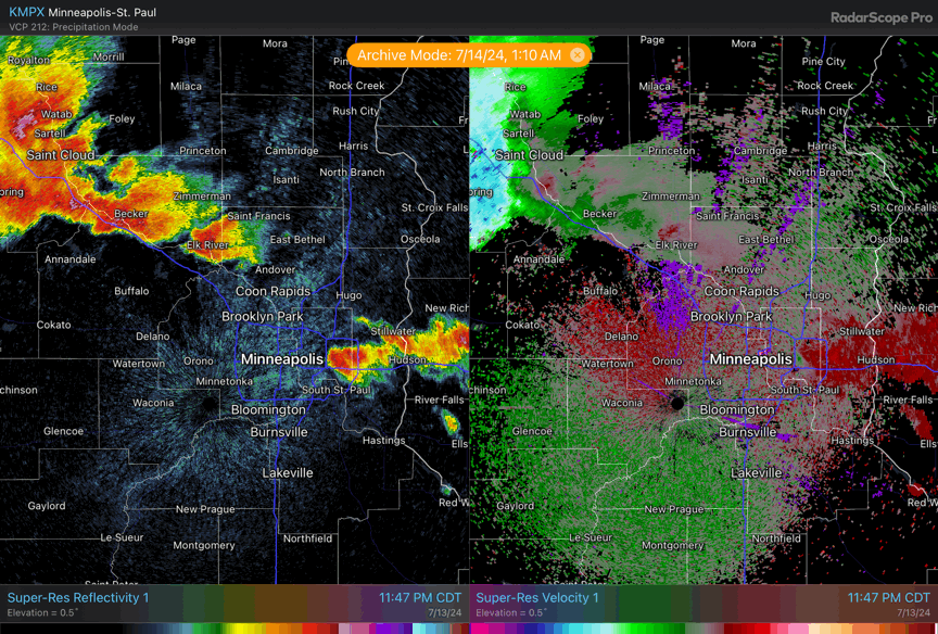
Radar
Radar loops showing reflectivity (left) and velocity (right) during the afternoon and overnight convection.
 |
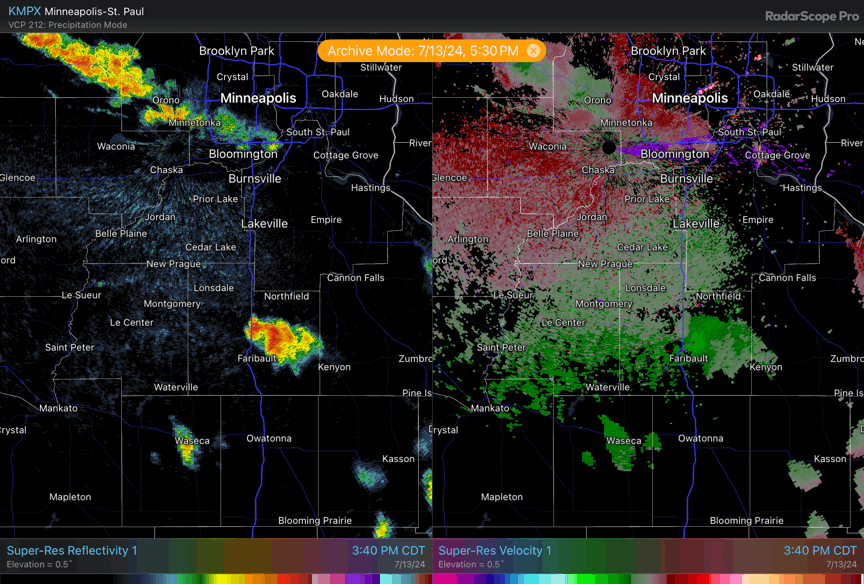 |
| A radar loop of thunderstorms in eastern Minnesota, one of which produced a brief tornado near Medford, MN. | A radar loop of a line of thunderstorms as they moved from central Minnesota into eastern Minnesota. Large hail and damaging wind gusts occurred along this line. |
Heat Indices
NOUS43 KMPX 140109
PNSMPX
MNZ041>045-047>070-073>078-082>085-091>093-WIZ014>016-023>028-141309-

Public Information Statement
National Weather Service Twin Cities/Chanhassen MN
809 PM CDT Sat Jul 13 2024

...MAXIMUM HEAT INDEX REPORTS...

The following list shows heat index values of 100 degrees or
higher that were reported today at ASOS and AWOS stations.

Location                     Heat Idx. Time/Date       Provider
Madison AP                   113 F     0655 PM 07/13   AWOS
St. James AP                 111 F     0735 PM 07/13   AWOS
Granite Falls AP             108 F     0539 PM 07/13   AWOS
Canby AP                     103 F     0655 PM 07/13   AWOS
Fairmont AP                  103 F     0656 PM 07/13   AWOS
Mankato AP                   102 F     0456 PM 07/13   AWOS
Redwood Falls AP             102 F     0653 PM 07/13   ASOS
Albert Lea AP                100 F     0656 PM 07/13   AWOS
Appleton AP                  100 F     0753 PM 07/13   AWOS
Montevideo AP                100 F     0735 PM 07/13   AWOS

Observations are collected from a variety of sources with varying
equipment and exposures. We thank all volunteer weather observers
for their dedication. Not all data listed are considered official.

$$
 |
Media use of NWS Web News Stories is encouraged! Please acknowledge the NWS as the source of any news information accessed from this site. |
|