Heat expands across the Desert Southwest, Plains, Mississippi Valley and Midwest into Monday. Fire weather concerns continue for portions of the Intermountain West. Active monsoonal moisture fuels thunderstorms over the Southwest with possible flash flooding. Tropical cyclone Fausto in the Pacific, should weaken as it approaches Hawaii; Dangerous surf, swells and rip currents are expected. Read More >
Overview
|
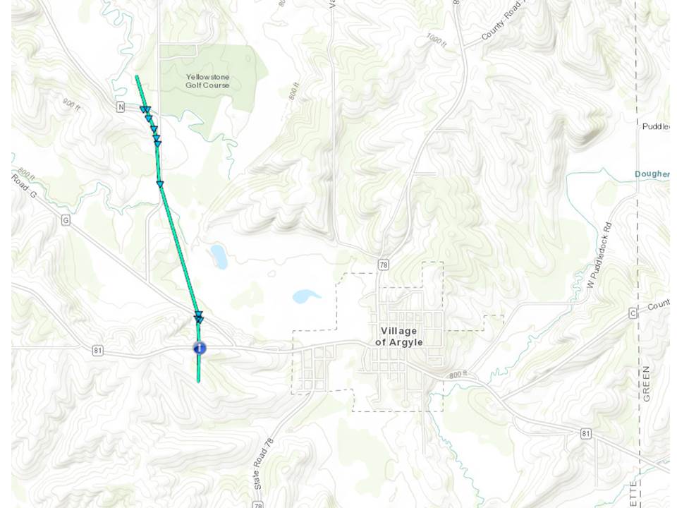
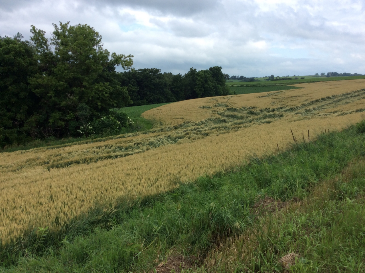
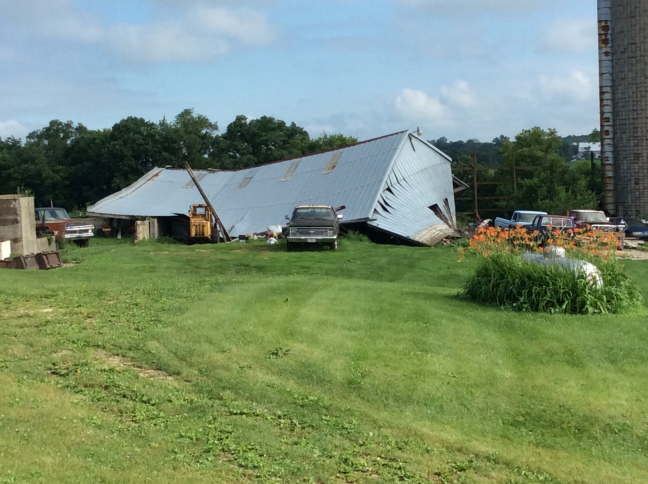
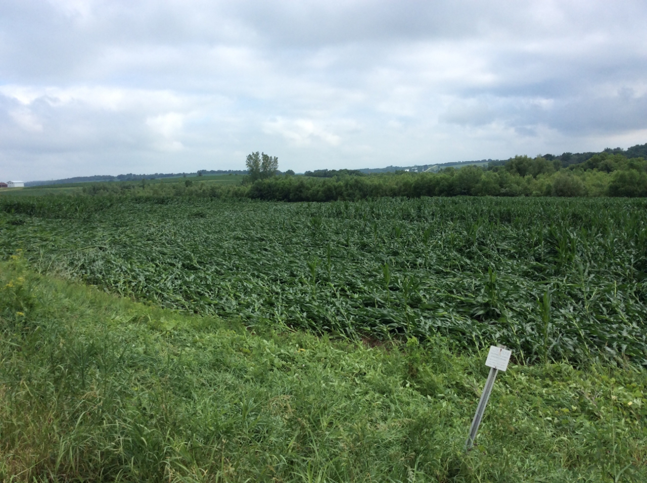
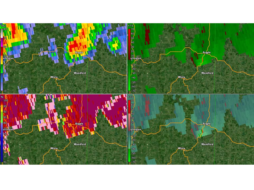
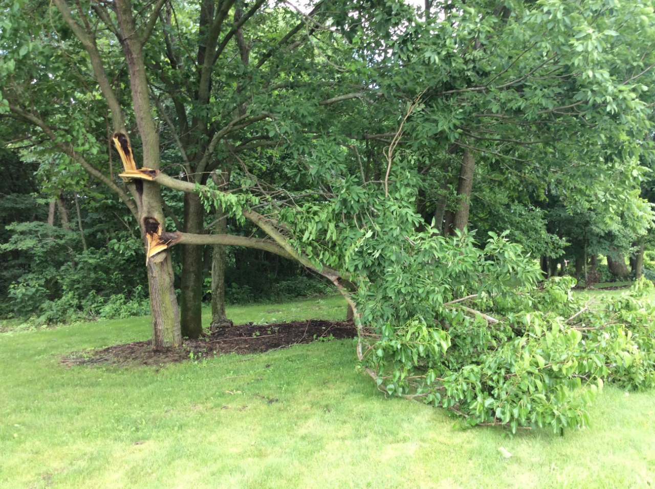
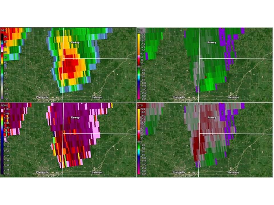
Two EF-0 tornadoes were confirmed by an NWS storm survey. Thunderstorms impacted southern Wisconsin on Tuesday June 26th. A warm front pushed north into the region which helped create rotation with several storms. The environment was primed for weak, short lived tornadoes. One EF-0 tornado touched down 4 miles south of Rewey in far northwestern Lafayette County and another EF-0 tornado occurred from 1 mile west to 2 miles northwest of Argyle in far eastern Lafayette County. |
Tornadoes:
|
Tornado - 2 NW of Argyle
Track Map 
|
||||||||||||||||
|
||||||||||||||||
|
Tornado - 5 S Rewey
Track Map 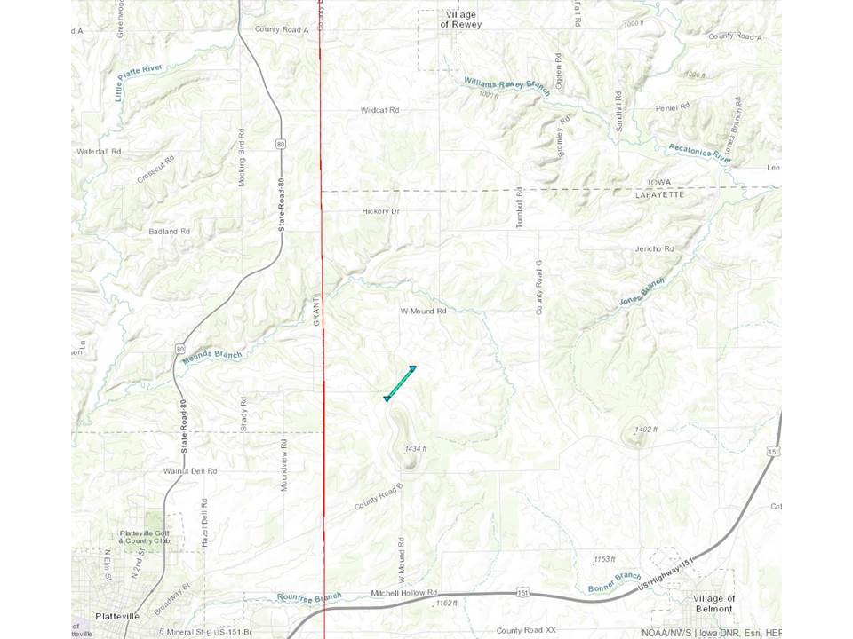
|
||||||||||||||||
|
||||||||||||||||
The Enhanced Fujita (EF) Scale classifies tornadoes into the following categories:
| EF0 Weak 65-85 mph |
EF1 Moderate 86-110 mph |
EF2 Significant 111-135 mph |
EF3 Severe 136-165 mph |
EF4 Extreme 166-200 mph |
EF5 Catastrophic 200+ mph |
 |
|||||
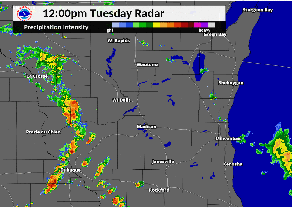
Radar / Rainfall:
Header
 |
|
| Caption | Caption |
Storm Reports
758 AM CDT Wed Jun 27 2018

...RAINFALL REPORTS...

Location                     Amount    Time/Date       Lat/Lon

...Wisconsin...

...Columbia County...
Lodi                         1.64 in   0739 AM 06/27   43.31N/89.54W
Lodi                         0.67 in   0744 AM 06/27   43.32N/89.54W
Lodi                         0.55 in   0700 AM 06/27   43.32N/89.53W
5 WSW Portage                0.39 in   0500 AM 06/27   43.51N/89.57W
7 WSW Portage                0.38 in   0700 AM 06/27   43.48N/89.57W
5 NW Portage                 0.36 in   0742 AM 06/27   43.61N/89.54W
1 NNW Pardeeville            0.35 in   0714 AM 06/27   43.56N/89.31W
Wisconsin Dells              0.32 in   0400 AM 06/27   43.63N/89.77W
3 NE Lake Wisconsin          0.27 in   0700 AM 06/27   43.41N/89.53W
Poynette                     0.20 in   0739 AM 06/27   43.39N/89.40W
Portage                      0.08 in   0741 AM 06/27   43.54N/89.46W
Arlington                    0.01 in   0740 AM 06/27   43.34N/89.39W

...Dane County...
Mt Horeb                     2.55 in   0700 AM 06/27   42.98N/89.74W
Mount Horeb                  2.38 in   0700 AM 06/27   43.00N/89.73W
Stoughton                    2.08 in   0739 AM 06/27   42.92N/89.20W
5 WNW Verona                 1.62 in   0700 AM 06/27   43.03N/89.63W
1 WNW Middleton              1.49 in   0655 AM 06/27   43.11N/89.53W
Madison                      1.45 in   0658 AM 06/27   43.06N/89.48W
1 W Shorewood Hills          1.36 in   0700 AM 06/27   43.08N/89.47W
Stoughton                    1.25 in   0700 AM 06/27   42.92N/89.22W
Madison 4.3 WSW              1.24 in   0600 AM 06/27   43.05N/89.46W
1 SSW Shorewood Hills        1.14 in   0700 AM 06/27   43.06N/89.46W
1 ESE Shorewood Hills        1.04 in   0739 AM 06/27   43.07N/89.43W
4 SW Black Earth             1.00 in   0730 AM 06/27   43.08N/89.78W
Oregon                       1.00 in   0740 AM 06/27   42.92N/89.39W
Black Earth                  0.84 in   0736 AM 06/27   43.13N/89.75W
2 WSW Windsor                0.59 in   0736 AM 06/27   43.21N/89.38W
2 NNE Sun Prairie            0.51 in   0747 AM 06/27   43.22N/89.22W
1 SSW Sun Prairie            0.44 in   0740 AM 06/27   43.17N/89.24W
Sun Prairie                  0.43 in   0750 AM 06/27   43.19N/89.22W
Madison-Dane County Airport  0.42 in   0653 AM 06/27   43.14N/89.34W

...Dodge County...
2 N Watertown                0.63 in   0739 AM 06/27   43.23N/88.73W
Horicon-WWTP                 0.30 in   0700 AM 06/27   43.45N/88.63W
Dodge County Apt             0.29 in   0655 AM 06/27   43.43N/88.70W
Theresa                      0.26 in   0700 AM 06/27   43.51N/88.46W
Beaver Dam                   0.23 in   0749 AM 06/27   43.45N/88.83W
3 NW Kekoskee                0.15 in   0728 AM 06/27   43.57N/88.61W
2 WNW Beaver Dam             0.12 in   0630 AM 06/27   43.48N/88.89W

...Fond du Lac County...
3 E Lomira                   0.18 in   0730 AM 06/27   43.59N/88.37W
Mount Calvary 1.6 WSW        0.09 in   0700 AM 06/27   43.82N/88.28W
Waupun                       0.09 in   0715 AM 06/27   43.63N/88.73W
Taycheedah                   0.07 in   0600 AM 06/27   43.83N/88.35W
1 NNW Fond Du Lac            0.06 in   0700 AM 06/27   43.80N/88.46W
Fond Du Lac                  0.03 in   0700 AM 06/27   43.77N/88.47W
Fond Du Lac-mid              0.02 in   1200 AM 06/27   43.63N/88.45W
Fond Du Lac Airport          0.01 in   0653 AM 06/27   43.77N/88.49W

...Green County...
New Glarus                   0.30 in   0743 AM 06/27   42.82N/89.64W
Monroe                       0.03 in   0655 AM 06/27   42.62N/89.59W

...Green Lake County...
Princeton                    0.28 in   0739 AM 06/27   43.84N/89.12W
3 ESE Princeton              0.12 in   0700 AM 06/27   43.82N/89.08W
Green Lake                   0.09 in   0700 AM 06/27   43.84N/88.94W

...Iowa County...
Barneveld 1 S                1.70 in   0700 AM 06/27   43.00N/89.89W
Mineral Point                1.18 in   0736 AM 06/27   42.85N/90.18W
5 SE Dodgeville              1.06 in   0700 AM 06/27   42.91N/90.06W
4 N Dodgeville               0.83 in   0711 AM 06/27   43.02N/90.14W

...Jefferson County...
Waterloo                     0.80 in   0740 AM 06/27   43.19N/88.99W
1 NW Whitewater              0.75 in   0700 AM 06/27   42.85N/88.75W
Watertown                    0.65 in   0700 AM 06/27   43.18N/88.72W
Whitewater                   0.53 in   0710 AM 06/27   42.86N/88.73W
Waterloo                     0.53 in   0737 AM 06/27   43.19N/88.98W
Watertown                    0.52 in   0700 AM 06/27   43.17N/88.74W
1 N Palmyra                  0.48 in   0700 AM 06/27   42.90N/88.59W
2 SW Johnson Creek           0.32 in   0545 AM 06/27   43.05N/88.80W
Fort Atkinson                0.25 in   0737 AM 06/27   42.93N/88.83W
Watertown                    0.21 in   0655 AM 06/27   43.17N/88.72W
Jefferson                    0.06 in   0715 AM 06/27   43.02N/88.82W

...Kenosha County...
2 WSW Kenosha                2.71 in   0700 AM 06/27   42.56N/87.86W
1 NW Kenosha                 2.57 in   0743 AM 06/27   42.60N/87.83W
Pleasant Prairie             1.60 in   0600 AM 06/27   42.56N/87.94W
2 ENE Twin Lakes             1.27 in   0742 AM 06/27   42.53N/88.22W
Kenosha-Airport              1.22 in   0653 AM 06/27   42.60N/87.93W

...Lafayette County...
4 WNW Gratiot                1.13 in   0700 AM 06/27   42.61N/90.10W
Benton                       0.59 in   0630 AM 06/27   42.57N/90.39W
3 SSW South Wayne            0.13 in   0600 AM 06/27   42.51N/89.90W

...Milwaukee County...
1 N West Milwaukee           1.68 in   0740 AM 06/27   43.03N/87.97W
1 ENE Greendale              1.52 in   0740 AM 06/27   42.94N/87.98W
1 ENE Greendale              1.48 in   0700 AM 06/27   42.94N/87.98W
2 NE West Allis              1.40 in   0739 AM 06/27   43.03N/88.01W
Milwaukee-Gen Mitchell Arpt  1.36 in   0652 AM 06/27   42.95N/87.90W
2 ENE Franklin               1.36 in   0700 AM 06/27   42.90N/87.97W
1 E Glendale                 1.16 in   0740 AM 06/27   43.13N/87.91W
1 NNW Saint Francis          1.15 in   0735 AM 06/27   42.99N/87.88W
Franklin                     1.07 in   0727 AM 06/27   42.90N/88.02W
West Allis                   0.95 in   0740 AM 06/27   43.00N/88.02W
Oak Creek                    0.94 in   0732 AM 06/27   42.90N/87.90W
1 E Wauwatosa                0.88 in   0700 AM 06/27   43.06N/88.00W
1 S West Allis               0.81 in   0741 AM 06/27   42.98N/88.03W
South Milwaukee-WWTP         0.80 in   0700 AM 06/27   42.90N/87.85W
3 WSW Glendale               0.78 in   0600 AM 06/27   43.11N/87.99W
Mt. Mary College             0.75 in   0700 AM 06/27   43.07N/88.03W
1 SW Glendale                0.71 in   0745 AM 06/27   43.12N/87.94W
Brown Deer                   0.65 in   0600 AM 06/27   43.18N/87.98W
Brown Deer                   0.63 in   0741 AM 06/27   43.17N/87.99W
Brown Deer                   0.26 in   0740 AM 06/27   43.18N/87.98W
1 ESE Saint Francis          0.01 in   0732 AM 06/27   42.96N/87.85W

...Ozaukee County...
Port Washington              2.04 in   0739 AM 06/27   43.40N/87.88W
Saukville-WWTP               1.44 in   0600 AM 06/27   43.37N/87.94W
3 W Cedarburg                1.04 in   0741 AM 06/27   43.29N/88.06W
Port Washington              0.87 in   0700 AM 06/27   43.40N/87.87W
Newburg                      0.22 in   0700 AM 06/27   43.43N/88.04W
Belgium-WWTP                 0.22 in   0711 AM 06/27   43.51N/87.85W
Cedarburg                    0.04 in   0740 AM 06/27   43.29N/87.99W
2 ESE Cedarburg              0.03 in   0400 AM 06/27   43.28N/87.94W

...Racine County...
Elmwood Park                 2.00 in   0700 AM 06/27   42.69N/87.81W
Burlington                   1.87 in   0655 AM 06/27   42.69N/88.31W
1 NNW Racine                 1.78 in   0700 AM 06/27   42.75N/87.79W
Rochester                    1.56 in   0645 AM 06/27   42.74N/88.22W
Waterford                    1.52 in   0730 AM 06/27   42.77N/88.21W
Rochester-WWTP               1.48 in   0600 AM 06/27   42.73N/88.23W
Wind Lake                    1.42 in   0700 AM 06/27   42.82N/88.17W
Racine-Sewage Plant          1.40 in   0600 AM 06/27   42.68N/88.20W
Wind Lake                    1.39 in   0715 AM 06/27   42.81N/88.14W
Wind Lake                    1.35 in   0700 AM 06/27   42.83N/88.15W
1 NW Wind Point              1.33 in   0744 AM 06/27   42.80N/87.79W
3 S Oak Creek                1.24 in   0740 AM 06/27   42.83N/87.89W
Racine-Batten Airport        1.18 in   0653 AM 06/27   42.76N/87.81W
3 NE Sturtevant              1.05 in   0700 AM 06/27   42.74N/87.86W
3 SSE Franklin               1.02 in   0700 AM 06/27   42.83N/87.99W
1 NW Elmwood Park            1.00 in   0700 AM 06/27   42.71N/87.85W
4 N Union Grove              0.88 in   0742 AM 06/27   42.75N/88.04W

...Rock County...
Beloit                       2.05 in   0540 AM 06/27   42.50N/89.03W
2 NNW Clinton                1.90 in   0700 AM 06/27   42.60N/88.88W
Beloit                       1.68 in   0605 AM 06/27   42.52N/89.01W
Evansville                   0.96 in   0700 AM 06/27   42.78N/89.29W
3 S Edgerton                 0.83 in   0736 AM 06/27   42.79N/89.07W
3 W Janesville               0.74 in   0700 AM 06/27   42.68N/89.08W
Milton-WWTP                  0.72 in   0700 AM 06/27   42.78N/88.94W

...Sauk County...
Lone Rock-Airport            2.03 in   0656 AM 06/27   43.21N/90.19W
2 WSW Rock Springs           0.79 in   0700 AM 06/27   43.46N/89.97W
1 N Reedsburg                0.78 in   0505 AM 06/27   43.55N/90.00W
Reedsburg-Airport            0.50 in   0655 AM 06/27   43.53N/89.98W
Baraboo                      0.44 in   0655 AM 06/27   43.52N/89.77W
1 SSE Lake Delton            0.40 in   0739 AM 06/27   43.57N/89.77W
Baraboo-WWTP                 0.40 in   0740 AM 06/27   43.48N/89.63W
2 ENE North Freedom          0.38 in   0700 AM 06/27   43.47N/89.83W
Baraboo                      0.38 in   0736 AM 06/27   43.47N/89.73W
1 NE Baraboo                 0.36 in   0748 AM 06/27   43.49N/89.72W

...Sheboygan County...
1 SW Sheboygan               0.71 in   0600 AM 06/27   43.74N/87.73W
2 NNW Sheboygan              0.64 in   0740 AM 06/27   43.78N/87.72W
Random Lake                  0.16 in   0740 AM 06/27   43.55N/87.95W
Hingham                      0.14 in   0700 AM 06/27   43.64N/87.91W
Plymouth                     0.09 in   0735 AM 06/27   43.75N/87.97W
3 NNE Kohler                 0.08 in   0630 AM 06/27   43.78N/87.77W
3 NNE Kohler                 0.07 in   0744 AM 06/27   43.78N/87.77W
Sheboygan-Airport            0.06 in   0653 AM 06/27   43.77N/87.85W
4 WSW Howards Grove          0.06 in   0603 AM 06/27   43.81N/87.91W
3 WNW Sheboygan              0.04 in   0739 AM 06/27   43.78N/87.75W

...Walworth County...
Pell Lake                    2.22 in   0640 AM 06/27   42.53N/88.33W
2 SW Delavan Lake            2.11 in   0700 AM 06/27   42.58N/88.65W
Lake Geneva                  2.09 in   0700 AM 06/27   42.59N/88.42W
Genoa City                   1.67 in   0748 AM 06/27   42.50N/88.32W
6 N Elkhorn                  1.61 in   0500 AM 06/27   42.76N/88.55W
Elkhorn                      1.59 in   0530 AM 06/27   42.67N/88.53W
Whitewater                   0.64 in   0740 AM 06/27   42.83N/88.75W

...Washington County...
2 E Jackson                  1.16 in   0739 AM 06/27   43.31N/88.12W
3 SSW Richrield              0.91 in   0600 AM 06/27   43.21N/88.21W
Jackson                      0.78 in   0620 AM 06/27   43.31N/88.16W
3 ESE Jackson                0.78 in   0500 AM 06/27   43.29N/88.11W
Jackson                      0.56 in   0735 AM 06/27   43.32N/88.17W
1 ESE Hartford               0.49 in   0550 AM 06/27   43.31N/88.36W
2 W Hartford                 0.34 in   0630 AM 06/27   43.32N/88.40W
Slinger                      0.31 in   0700 AM 06/27   43.33N/88.30W
West Bend-Public Works       0.27 in   0700 AM 06/27   43.41N/88.19W
1 ESE West Bend              0.27 in   0743 AM 06/27   43.41N/88.15W
3 W West Bend                0.16 in   0700 AM 06/27   43.41N/88.25W
4 WNW West Bend              0.12 in   0745 AM 06/27   43.45N/88.26W
West Bend                    0.08 in   0739 AM 06/27   43.42N/88.19W

...Waukesha County...
1 NNE Waukesha               1.81 in   0742 AM 06/27   43.04N/88.22W
2 NE Wind Lake               1.40 in   0645 AM 06/27   42.85N/88.13W
2 SE Eagle                   1.26 in   0749 AM 06/27   42.85N/88.44W
Muskego                      1.26 in   0600 AM 06/27   42.89N/88.14W
2 SE Eagle                   1.23 in   0700 AM 06/27   42.85N/88.44W
Big Bend                     1.14 in   0700 AM 06/27   42.88N/88.21W
1 WNW New Berlin             1.10 in   0700 AM 06/27   42.98N/88.16W
Elm Grove                    1.08 in   0738 AM 06/27   43.05N/88.08W
Brookfield                   1.03 in   0739 AM 06/27   43.06N/88.14W
Butler                       1.00 in   0740 AM 06/27   43.11N/88.07W
Delafield                    0.91 in   0743 AM 06/27   43.07N/88.40W
1 NW Waukesha                0.86 in   0700 AM 06/27   43.03N/88.26W
2 NW Hales Corners           0.83 in   0740 AM 06/27   42.97N/88.07W
1 NNE Merton                 0.80 in   0508 AM 06/27   43.16N/88.30W
New Berlin                   0.80 in   0700 AM 06/27   42.97N/88.12W
Okauchee Lake                0.80 in   0743 AM 06/27   43.11N/88.44W
Oconomowoc South             0.72 in   0744 AM 06/27   43.11N/88.50W
2 SSE Wales                  0.70 in   0643 AM 06/27   42.97N/88.36W
1 SSW Lac La Belle           0.55 in   0700 AM 06/27   43.13N/88.53W
Muskego                      0.24 in   0740 AM 06/27   42.89N/88.14W

Observations are collected from a variety of sources with varying
equipment and exposures. We thank all volunteer weather observers
for their dedication. Not all data listed are considered official.
 |
Media use of NWS Web News Stories is encouraged! Please acknowledge the NWS as the source of any news information accessed from this site. |
|