Catastrophic Super Typhoon Bavi's eyewall has reached Rota and is expected to bring dangerous winds, heavy rainfall and storm surge to Guam, Rota, Tinian and Saipan. A Typhoon Warning remains in effect. Heavy to excessive rainfall will continue to bring a flooding threat from coastal Mid-Atlantic to southern New England through Monday. Read More >
Overview:
|
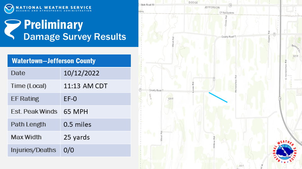
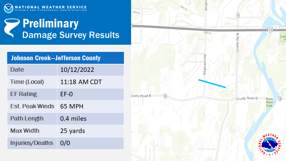
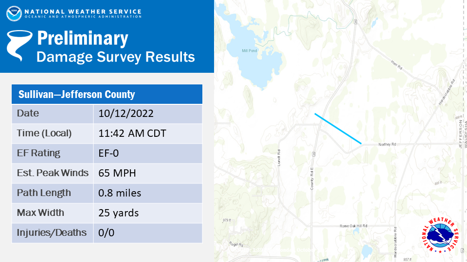
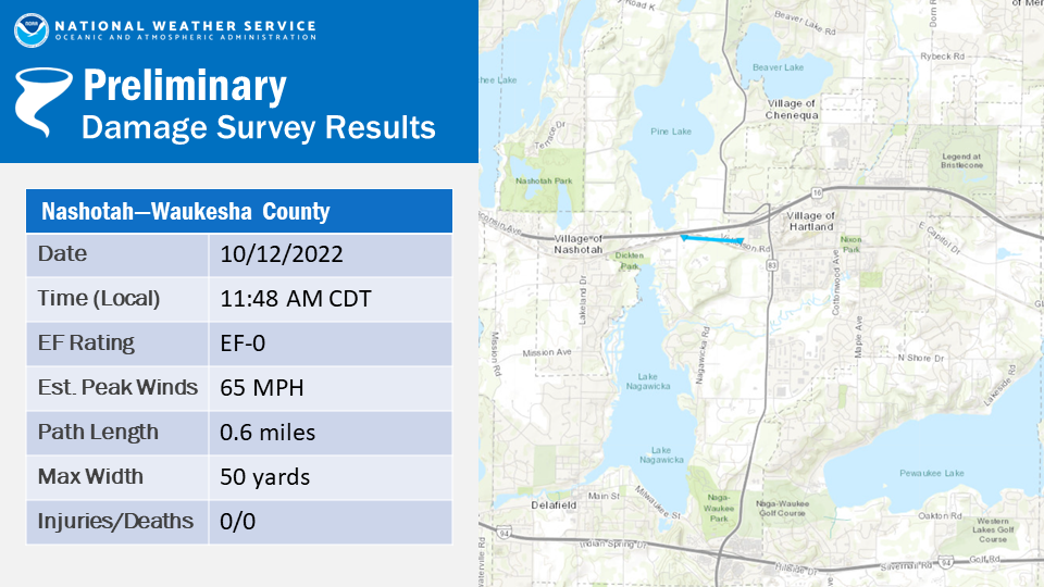
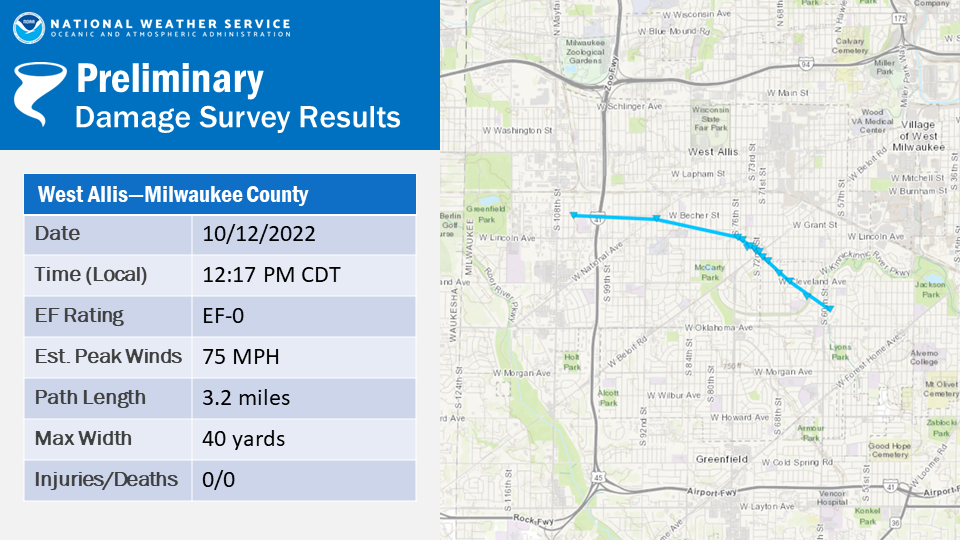
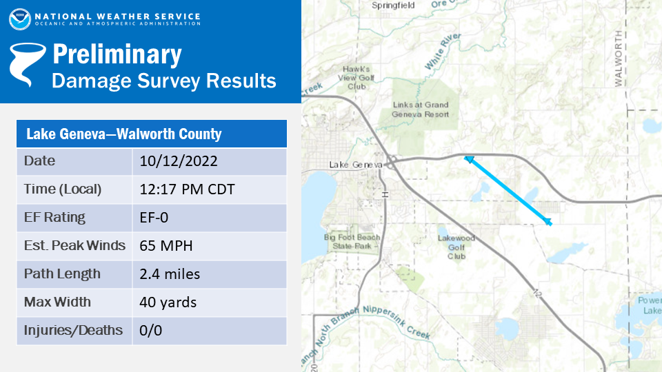
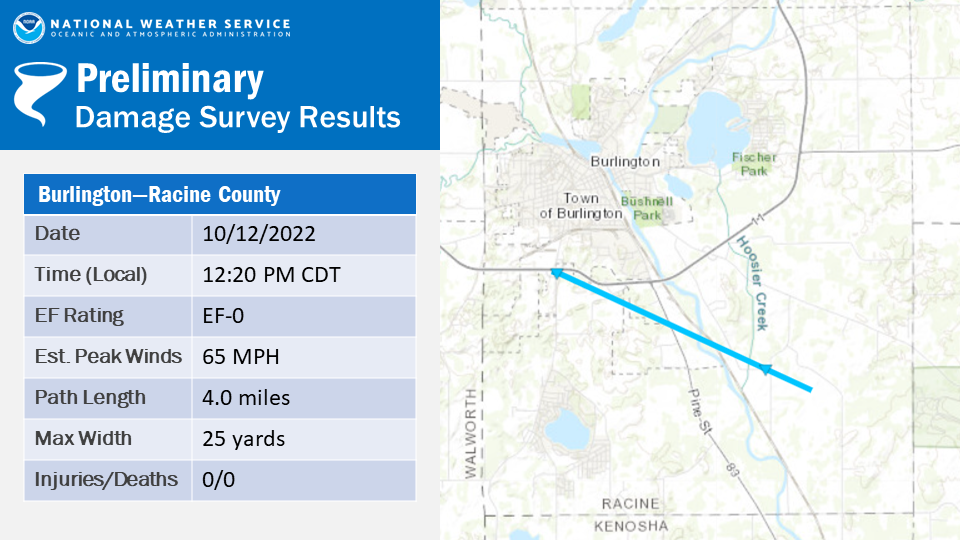
A line of thunderstorms moved eastward across southeast Wisconsin during the late morning and early afternoon hours on Wednesday, October 12, 2022. This line of storms produced 7 EF-0 rated tornadoes, along with multiple areas of straight line wind damage. |
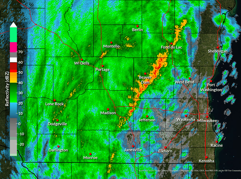 Radar Loop Of Storms Moving Through Southeast Wisconsin Between 11:00 AM CDT and 1:09 PM CDT |
Tornadoes:
|
Downloadable: Tornado tracks KMZ files |
The Enhanced Fujita (EF) Scale classifies tornadoes into the following categories:
| EF0 Weak 65-85 mph |
EF1 Moderate 86-110 mph |
EF2 Significant 111-135 mph |
EF3 Severe 136-165 mph |
EF4 Extreme 166-200 mph |
EF5 Catastrophic 200+ mph |
 |
|||||
Damage Reports
Here is a link to a map of Local Storm Reports.
Here is a link to the text products of the Local Storm Reports.
See below for a list of damage reports:
..TIME...   ...EVENT...      ...CITY LOCATION...     ...LAT.LON...
..DATE...   ....MAG....      ..COUNTY LOCATION..ST.. ...SOURCE....
            ..REMARKS..

1145 AM     TSTM WND GST     HARTFORD                43.33N 88.39W
10/12/2022  E60 MPH          WASHINGTON         WI   PUBLIC

            RELAYED VIA SOCIAL MEDIA.

1155 AM     TSTM WND GST     8 NNW DELAVAN           42.73N 88.68W
10/12/2022  E60 MPH          WALWORTH           WI   EMERGENCY MNGR

            STRAIGHT LINE WIND DAMAGE REPORT OF AN
            UPROOTED TREE ON A HOUSE AND A PIER RIPPED
            UP ON TURTLE LAKE. RELAYED VIA DELAVAN FIRE
            CHIEF.

1229 PM     TSTM WND GST     1 NE CUDAHY             42.95N 87.85W
10/12/2022  M73 MPH          MILWAUKEE          WI   PUBLIC

            NUMEROUS TREES AND BRANCHES DOWN.

1234 PM     TSTM WND GST     2 W CUDAHY              42.95N 87.90W
10/12/2022  M59 MPH          MILWAUKEE          WI   PUBLIC

            PEAK GUST AT MITCHELL INTERNATIONAL.

0941 AM     TSTM WND DMG     MONTELLO                43.79N 89.33W
10/12/2022                   MARQUETTE          WI   PUBLIC

            LARGE BRANCHES DOWN. PATIO TABLE AND CHAIRS
            BLOWN OVER. TIME ESTIMATED FROM RADAR.

1139 AM     TSTM WND DMG     1 NNE OCONOMOWOC        43.11N 88.49W
10/12/2022                   WAUKESHA           WI   PUBLIC

            MPING REPORTS FROM LAC LA BELLE, OCONOMOWOC
            AND HARTLAND OF TREES UPROOTED OR SNAPPED.
            TIME ESTIMATED FROM RADAR.

1143 AM     TSTM WND DMG     1 S OKAUCHEE LAKE       43.11N 88.44W
10/12/2022                   WAUKESHA           WI   PUBLIC

            REPORTS OF MULTIPLE TREES DOWN AND A FEW
            POWERLINES DOWN. TIME ESTIMATED FROM RADAR.

1153 AM     TSTM WND DMG     MERTON                  43.14N 88.31W
10/12/2022                   WAUKESHA           WI   PUBLIC

            TREE SNAPPED AND LARGE LIMBS DOWN. TIME
            ESTIMATED FROM RADAR.

1210 PM     TSTM WND DMG     BROOKFIELD              43.06N 88.12W
10/12/2022                   WAUKESHA           WI   PUBLIC

            LARGE TREE DOWN. TIME ESTIMATED FROM RADAR.

1219 PM     TSTM WND DMG     2 WNW WAUKESHA          43.02N 88.27W
10/12/2022                   WAUKESHA           WI   PUBLIC

            LIMB DOWN. 1.5 FOOT DIAMETER.

1224 PM     TSTM WND DMG     1 ESE WEST ALLIS        43.00N 88.00W
10/12/2022                   MILWAUKEE          WI   PUBLIC

            LARGE TREES DOWN ON HAYES AVENUE BETWEEN
            72ND AND 74TH STREETS. POWER LINES DOWN ON
            72ND STREET BETWEEN HAYES AVENUE AND BELOIT
            ROAD. TIME ESTIMATED FROM RADAR.

1224 PM     TSTM WND DMG     2 ESE BURLINGTON        42.66N 88.25W
10/12/2022                   RACINE             WI   PUBLIC

            LARGE TREES DOWN. ROOF DAMAGE ON A NEARBY
            BARN. TIME ESTIMATED FROM RADAR.

1226 PM     TSTM WND DMG     1 E BUTLER              43.11N 88.04W
10/12/2022                   MILWAUKEE          WI   PUBLIC

            REPORT FROM MPING: 3-INCH TREE LIMBS BROKEN;
            POWER POLES BROKEN. ESTIMATED 50-60 MPH.

1230 PM     TSTM WND DMG     2 W SAINT FRANCIS       42.97N 87.91W
10/12/2022                   MILWAUKEE          WI   PUBLIC

            3 INCH DIAMETER TREE LIMBS SNAPPED AT 2ND
            STREET AND PLAINFIELD AVENUE. TIME ESTIMATED
            FROM RADAR.

1230 PM     TSTM WND DMG     SAINT FRANCIS           42.97N 87.88W
10/12/2022                   MILWAUKEE          WI   PUBLIC

            LARGE TREE LIMBS DOWN. TIME ESTIMATED FROM
            RADAR.

1238 PM     TSTM WND DMG     2 SSE DARIEN            42.58N 88.70W
10/12/2022                   WALWORTH           WI   PUBLIC

            REPORT FROM MPING: 3-INCH TREE LIMBS BROKEN;
            POWER POLES BROKEN.

1240 PM     TSTM WND DMG     1 W SAINT FRANCIS       42.97N 87.90W
10/12/2022                   MILWAUKEE          WI   PUBLIC

            TREE BRANCHES DOWN ALONG E BOLIVAR AVE ALONG
            WITH SOME YARD DECORATIONS DAMAGED.

1246 PM     TSTM WND DMG     WEST ALLIS              43.01N 88.03W
10/12/2022                   MILWAUKEE          WI   PUBLIC

            TREES DOWNED 68TH & HARRISON AND 65TH &
            CLEVELAND AVE MILWAUKEE/WEST ALLIS BORDER.

1247 PM     TSTM WND DMG     3 ENE BRISTOL           42.57N 87.99W
10/12/2022                   KENOSHA            WI   PUBLIC

            LARGE TREE LIMB DOWN. TIME ESTIMATED FROM
            RADAR.

1247 PM     TSTM WND DMG     2 WSW NORTH BAY         42.75N 87.83W
10/12/2022                   RACINE             WI   PUBLIC

            TREES AND LARGE BRANCHES DOWN. TIME
            ESTIMATED FROM RADAR.

1252 PM     TSTM WND DMG     MILWAUKEE               43.05N 87.91W
10/12/2022                   MILWAUKEE          WI   PUBLIC

            REPORT FROM MPING: 1-INCH TREE LIMBS BROKEN;
            SHINGLES BLOWN OFF.

0100 PM     TSTM WND DMG     3 SSE WEST MILWAUKEE    42.97N 87.94W
10/12/2022                   MILWAUKEE          WI   PUBLIC

            LARGE LIMBS DOWN. TIME ESTIMATED FROM RADAR.


&&

$$
 |
Media use of NWS Web News Stories is encouraged! Please acknowledge the NWS as the source of any news information accessed from this site. |
|