
Heat expands across the Desert Southwest, Plains, Mississippi Valley and Midwest into Monday. Fire weather concerns continue for portions of the Intermountain West. Active monsoonal moisture fuels thunderstorms over the Southwest with possible flash flooding. Tropical cyclone Fausto in the Pacific, should weaken as it approaches Hawaii; Dangerous surf, swells and rip currents are expected. Read More >
Overview
|
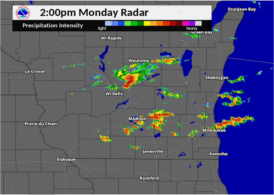
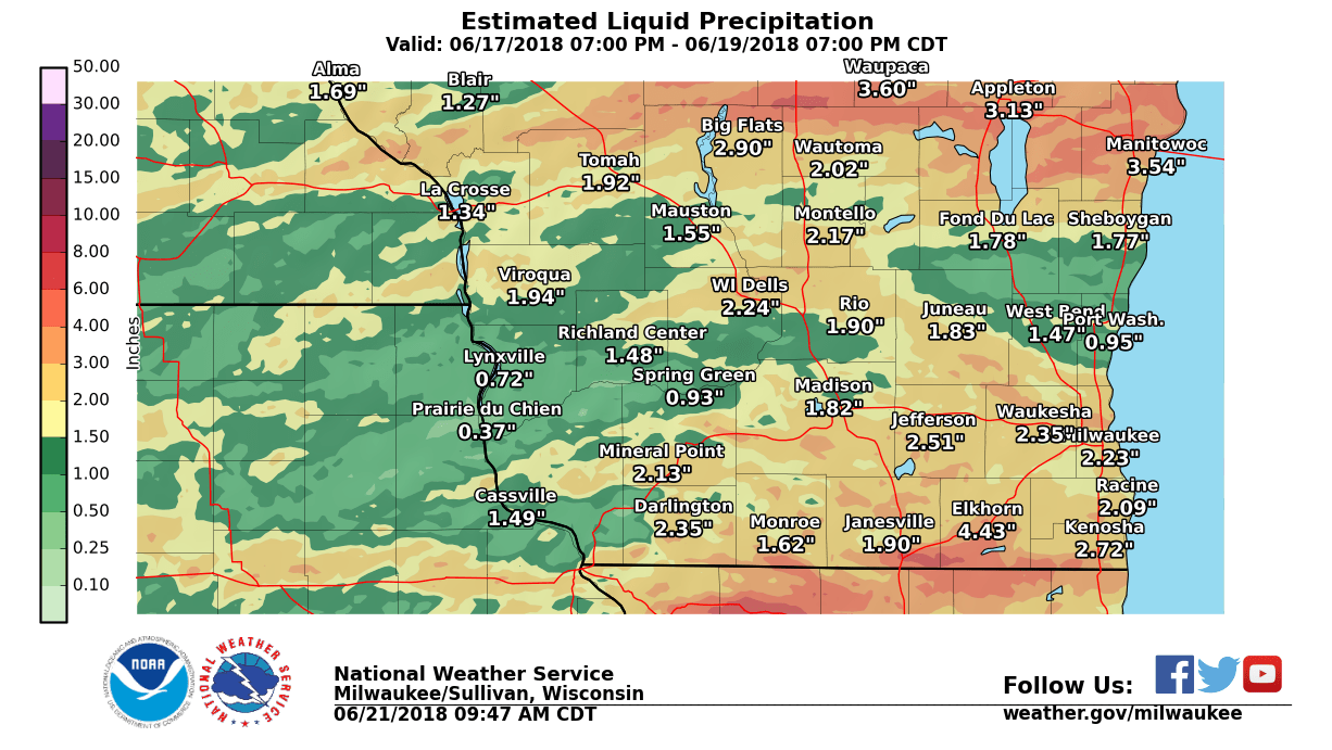
Heavy rain and thunderstorms impacted southern Wisconsin during the afternoon and evening hours on June 18, 2018. A cold front was moving southward across the state in a very saturated atmosphere. Rainfall amounts of 1 to 2 inches fell in as little as 30 minutes north of downtown Milwaukee, resulting in stalled cars in some areas. Storm total amounts were 3 to 5 inches in parts of Milwaukee and far southern Wisconsin, including Clinton and Beloit. Thunderstorms caused downed trees in some areas of Racine and Kenosha counties, as well as the Janesville area. |
Radar / Rainfall:
 |
 |
| Observed Radar Loop |
Observed Rainfall Totals for the 48 hours ending 6 PM 6/19/18 |
Storm Reports
PRELIMINARY LOCAL STORM REPORT
NATIONAL WEATHER SERVICE MILWAUKEE/SULLIVAN WI
949 AM CDT TUE JUN 19 2018

..TIME...   ...EVENT...      ...CITY LOCATION...     ...LAT.LON...
..DATE...   ....MAG....      ..COUNTY LOCATION..ST.. ...SOURCE....
            ..REMARKS..
0440 PM TSTM WND DMG PLEASANT PRAIRIE 42.55N 87.93W 06/18/2018 KENOSHA WI LAW ENFORCEMENT TREES AND POWER LINES DOWN COUNTY WIDE PER DISPATCH. 0425 PM TSTM WND DMG 4 NNW SILVER LAKE 42.60N 88.21W 06/18/2018 KENOSHA WI TRAINED SPOTTER TREE BLOWN DOWN ONTO RAILROAD TRACKS NEAR INTERSECTION OF HIGHWAY W (328TH AVE) AND 45TH ST IN WHEATLAND. TIME EST BY RADAR. 0422 PM TSTM WND DMG 1 SSW BOHNERS LAKE 42.61N 88.29W 06/18/2018 KENOSHA WI LAW ENFORCEMENT TREE DOWN BLOCKING ROAD NEAR INTERSECTION OF 292ND AVENUE AND 37TH STREET. 0357 PM TSTM WND DMG 1 WNW RACINE 42.74N 87.81W 06/18/2018 RACINE WI PUBLIC MATURE OAK TREE SPLIT AT THE BASE JUST SOUTH OF THE RACINE AIRPORT. 0355 PM FLOOD 2 NW GLENDALE 43.15N 87.96W 06/18/2018 MILWAUKEE WI PUBLIC REPORT OF WATER OVER INTERSECTION OF GOOD HOPE RD AND TEUTONIA AVE. 0345 PM HEAVY RAIN 2 N BUTLER 43.14N 88.06W 06/18/2018 M1.34 INCH MILWAUKEE WI PUBLIC 1.34 INCHES IN 30 MINS NEAR INTERSECTION OF GOOD HOPE AND 124TH STREET. 0337 PM TSTM WND DMG 3 NE JANESVILLE 42.71N 88.97W 06/18/2018 ROCK WI PUBLIC SEVERAL TREES AND LARGE BRANCHES DOWN ALONG WRIGHT ROAD ON NE SIDE OF JANESVILLE. 0335 PM TSTM WND DMG WATERFORD NORTH 42.79N 88.22W 06/18/2018 RACINE WI LAW ENFORCEMENT COUNTY DISPATCH REPORTS TREES AND LARGE BRANCHES DWON AS WELL AS POWER LINES DOWN SCATTERED ALL OVER THE COUNTY. 0325 PM TSTM WND DMG MUKWONAGO 42.86N 88.32W 06/18/2018 WAUKESHA WI LAW ENFORCEMENT TREES AND LARGE BRANCHES DOWN. TIME EST FROM RADAR. 0304 PM FLOOD 1 N MILWAUKEE 43.05N 87.91W 06/18/2018 MILWAUKEE WI PUBLIC REPORT OF WATER COVERING ROAD ON N WATER STREET IN DOWNTOWN MILWAUKEE . 0330 AM HEAVY RAIN 2 W BELOIT 42.52N 89.07W 06/19/2018 M5.76 INCH ROCK WI MESONET MESONET STATION BLTFS, 2 W BELOIT. 0700 AM HEAVY RAIN 2 NNW CLINTON 42.60N 88.88W 06/19/2018 M5.45 INCH ROCK WI CO-OP OBSERVER CO-OP OBSERVER STATION CLIW3, 2 NNW CLINTON. 0329 AM HEAVY RAIN 1 SSE LAKE DELTON 43.57N 89.77W 06/19/2018 M4.52 INCH SAUK WI MESONET MESONET STATION WSDLL, 1 SSE LAKE DELTON. 0700 AM HEAVY RAIN MT. MARY COLLEGE 43.07N 88.03W 06/19/2018 M3.83 INCH MILWAUKEE WI CO-OP OBSERVER CO-OP OBSERVER STATION MMCW3, MT. MARY COLLEGE. 0329 AM HEAVY RAIN PORT WASHINGTON 43.40N 87.88W 06/19/2018 M3.72 INCH OZAUKEE WI MESONET MESONET STATION PTWSH, PORT WASHINGTON. 0500 AM HEAVY RAIN 3 WSW GLENDALE 43.11N 87.99W 06/19/2018 M3.64 INCH MILWAUKEE WI COCORAHS COCORAHS STATION WI-MW-14, 3 WSW GLENDALE. 0933 AM HEAVY RAIN GENOA CITY 42.50N 88.32W 06/19/2018 M3.38 INCH WALWORTH WI MESONET MESONET STATION C8307, GENOA CITY. 0630 AM HEAVY RAIN 2 SW DELAVAN LAKE 42.58N 88.65W 06/19/2018 M3.30 INCH WALWORTH WI COCORAHS COCORAHS STATION WI-WW-10, 2 SW DELAVAN LAKE. 0705 AM HEAVY RAIN BELOIT 42.52N 89.01W 06/19/2018 M3.18 INCH ROCK WI COCORAHS COCORAHS STATION WI-RK-15, BELOIT. 0836 AM HEAVY RAIN WHITEWATER 42.86N 88.73W 06/19/2018 M3.12 INCH JEFFERSON WI CO-OP OBSERVER CO-OP OBSERVER STATION WHTW3, WHITEWATER. 0720 AM HEAVY RAIN MOUNT HOREB 43.00N 89.73W 06/19/2018 M3.03 INCH DANE WI COCORAHS COCORAHS STATION WI-DA-59, MOUNT HOREB. 0700 AM HEAVY RAIN 5 SE DODGEVILLE 42.91N 90.06W 06/19/2018 M2.94 INCH IOWA WI COCORAHS COCORAHS STATION WI-IW-3, 5 SE DODGEVILLE. 0730 AM HEAVY RAIN DELEVAN 42.63N 88.66W 06/19/2018 M2.93 INCH WALWORTH WI CO-OP OBSERVER CO-OP OBSERVER STATION DLNW3, DELEVAN. 0700 AM HEAVY RAIN 3 SE DOUSMAN 42.97N 88.44W 06/19/2018 M2.88 INCH WAUKESHA WI COCORAHS COCORAHS STATION WI-WK-57, 3 SE DOUSMAN. 0700 AM HEAVY RAIN 1 WSW EVANSVILLE 42.77N 89.32W 06/19/2018 M2.80 INCH ROCK WI COCORAHS COCORAHS STATION WI-RK-14, 1 WSW EVANSVILLE. 0700 AM HEAVY RAIN LAKE GENEVA 42.59N 88.42W 06/19/2018 M2.77 INCH WALWORTH WI COCORAHS COCORAHS STATION WI-WW-2, LAKE GENEVA. 0700 AM HEAVY RAIN MT HOREB 42.98N 89.74W 06/19/2018 M2.74 INCH DANE WI CO-OP OBSERVER CO-OP OBSERVER STATION MRBW3, MT HOREB. 0800 AM HEAVY RAIN EVANSVILLE 42.78N 89.29W 06/19/2018 M2.72 INCH ROCK WI COCORAHS COCORAHS STATION WI-RK-6, EVANSVILLE. 0700 AM HEAVY RAIN 1 NNE DARIEN 42.62N 88.70W 06/19/2018 M2.71 INCH WALWORTH WI COCORAHS COCORAHS STATION WI-WW-14, 1 NNE DARIEN. 0700 AM HEAVY RAIN MILWAUKEE-TIMMERMAN ARP 43.11N 88.03W 06/19/2018 M2.70 INCH MILWAUKEE WI CO-OP OBSERVER CO-OP OBSERVER STATION MWC, MILWAUKEE-TIMMERMAN ARPT. 0800 AM HEAVY RAIN MEQUON 3.1 SSW 43.19N 88.01W 06/19/2018 M2.63 INCH OZAUKEE WI COCORAHS COCORAHS STATION WI-OZ-8, MEQUON 3.1 SSW. 0700 AM HEAVY RAIN 2 SE MONTICELLO 42.72N 89.56W 06/19/2018 M2.62 INCH GREEN WI COCORAHS COCORAHS STATION WI-GN-5, 2 SE MONTICELLO. 0600 AM HEAVY RAIN 1 SW BEAVER DAM 43.45N 88.85W 06/19/2018 M2.54 INCH DODGE WI COCORAHS COCORAHS STATION WI-DD-4, 1 SW BEAVER DAM. 0500 AM HEAVY RAIN 5 WSW PORTAGE 43.51N 89.57W 06/19/2018 M2.53 INCH COLUMBIA WI COCORAHS COCORAHS STATION WI-CB-4, 5 WSW PORTAGE. 0700 AM HEAVY RAIN 1 SSW LAC LA BELLE 43.13N 88.53W 06/19/2018 M2.45 INCH WAUKESHA WI COCORAHS COCORAHS STATION WI-WK-46, 1 SSW LAC LA BELLE. 0730 AM HEAVY RAIN 1 NE TWIN LAKES 42.54N 88.24W 06/19/2018 M2.43 INCH KENOSHA WI COCORAHS COCORAHS STATION WI-KN-18, 1 NE TWIN LAKES. 0800 AM HEAVY RAIN 2 SE HARTLAND 43.06N 88.32W 06/19/2018 M2.39 INCH WAUKESHA WI COCORAHS COCORAHS STATION WI-WK-22, 2 SE HARTLAND. 0700 AM HEAVY RAIN 3 SSW MOUNT HOREB 42.96N 89.76W 06/19/2018 M2.34 INCH DANE WI COCORAHS COCORAHS STATION WI-DA-10, 3 SSW MOUNT HOREB. 0800 AM HEAVY RAIN 2 E JANESVILLE 42.69N 88.96W 06/19/2018 M2.33 INCH ROCK WI COCORAHS COCORAHS STATION WI-RK-16, 2 E JANESVILLE. 0533 AM HEAVY RAIN BELOIT 42.50N 89.03W 06/19/2018 M2.32 INCH ROCK WI CO-OP OBSERVER CO-OP OBSERVER STATION BLTW3, BELOIT. 0700 AM HEAVY RAIN WATERTOWN 43.18N 88.72W 06/19/2018 M2.31 INCH JEFFERSON WI COCORAHS COCORAHS STATION WI-JF-19, WATERTOWN. 0718 AM HEAVY RAIN ARGYLE 42.70N 89.02W 06/19/2018 M2.30 INCH ROCK WI CO-OP OBSERVER CO-OP OBSERVER STATION ARGW3, ARGYLE. 0600 AM HEAVY RAIN 3 SSW SOUTH WAYNE 42.51N 89.90W 06/19/2018 M2.27 INCH LAFAYETTE WI COCORAHS COCORAHS STATION WI-LF-6, 3 SSW SOUTH WAYNE. 0700 AM HEAVY RAIN MILTON-WWTP 42.78N 88.94W 06/19/2018 M2.25 INCH ROCK WI CO-OP OBSERVER CO-OP OBSERVER STATION MTOW3, MILTON-WWTP. 0600 AM HEAVY RAIN GERMANTOWN 43.23N 88.10W 06/19/2018 M2.21 INCH WASHINGTON WI COCORAHS COCORAHS STATION WI-WS-16, GERMANTOWN. 0450 AM HEAVY RAIN 1 N REEDSBURG 43.55N 90.00W 06/19/2018 M2.20 INCH SAUK WI COCORAHS COCORAHS STATION WI-SK-15, 1 N REEDSBURG. 0700 AM HEAVY RAIN WATERTOWN 43.17N 88.74W 06/19/2018 M2.20 INCH JEFFERSON WI CO-OP OBSERVER CO-OP OBSERVER STATION WATW3, WATERTOWN. 0700 AM HEAVY RAIN 1 N PALMYRA 42.90N 88.59W 06/19/2018 M2.15 INCH JEFFERSON WI COCORAHS COCORAHS STATION WI-JF-10, 1 N PALMYRA. 0928 AM HEAVY RAIN 1 NW KENOSHA 42.60N 87.83W 06/19/2018 M2.08 INCH KENOSHA WI MESONET MESONET STATION E4176, 1 NW KENOSHA. 0700 AM HEAVY RAIN 1 NW WHITEWATER 42.85N 88.75W 06/19/2018 M2.08 INCH JEFFERSON WI COCORAHS COCORAHS STATION WI-JF-5, 1 NW WHITEWATER. 0752 AM HEAVY RAIN BROOKFIELD 43.05N 88.18W 06/19/2018 M2.08 INCH WAUKESHA WI CO-OP OBSERVER CO-OP OBSERVER STATION BFDW3, BROOKFIELD. 0700 AM HEAVY RAIN 4 WNW GRATIOT 42.61N 90.10W 06/19/2018 M2.00 INCH LAFAYETTE WI COCORAHS COCORAHS STATION WI-LF-4, 4 WNW GRATIOT. 0700 AM HEAVY RAIN 1 ESE HARTFORD 43.31N 88.36W 06/19/2018 M1.95 INCH WASHINGTON WI COCORAHS COCORAHS STATION WI-WS-17, 1 ESE HARTFORD. 0700 AM HEAVY RAIN BROOKLYN 42.86N 89.36W 06/19/2018 M1.94 INCH DANE WI COCORAHS COCORAHS STATION WI-DA-44, BROOKLYN. 0600 AM HEAVY RAIN PLEASANT PRAIRIE 42.56N 87.94W 06/19/2018 M1.91 INCH KENOSHA WI COCORAHS COCORAHS STATION WI-KN-11, PLEASANT PRAIRIE. 0809 AM HEAVY RAIN OCONOMOWOC SOUTH 43.11N 88.50W 06/19/2018 M1.91 INCH WAUKESHA WI CO-OP OBSERVER CO-OP OBSERVER STATION ONCW3, OCONOMOWOC SOUTH. 0400 AM HEAVY RAIN WISCONSIN DELLS 43.63N 89.77W 06/19/2018 M1.90 INCH COLUMBIA WI COCORAHS COCORAHS STATION WI-CB-8, WISCONSIN DELLS. 0630 AM HEAVY RAIN 2 W HARTFORD 43.32N 88.40W 06/19/2018 M1.88 INCH WASHINGTON WI CO-OP OBSERVER CO-OP OBSERVER STATION HARW3, 2 W HARTFORD. 0745 AM HEAVY RAIN SOUTH MILWAUKEE-WWTP 42.90N 87.85W 06/19/2018 M1.87 INCH MILWAUKEE WI CO-OP OBSERVER CO-OP OBSERVER STATION SEEW3, SOUTH MILWAUKEE-WWTP. 0600 AM HEAVY RAIN 1 E MAPLE BLUFF 43.11N 89.35W 06/19/2018 M1.87 INCH DANE WI COCORAHS COCORAHS STATION WI-DA-52, 1 E MAPLE BLUFF. 0700 AM HEAVY RAIN UNION GROVE 42.70N 88.03W 06/19/2018 M1.86 INCH RACINE WI CO-OP OBSERVER CO-OP OBSERVER STATION UGRW3, UNION GROVE. 0700 AM HEAVY RAIN BIG BEND 42.88N 88.21W 06/19/2018 M1.84 INCH WAUKESHA WI CO-OP OBSERVER CO-OP OBSERVER STATION BBDW3, BIG BEND. 0655 AM HEAVY RAIN KENOSHA-AIRPORT 42.60N 87.93W 06/19/2018 M1.84 INCH KENOSHA WI ASOS ASOS STATION ENW, KENOSHA-AIRPORT. 0700 AM HEAVY RAIN 1 NE MERTON 43.15N 88.30W 06/19/2018 M1.84 INCH WAUKESHA WI COCORAHS COCORAHS STATION WI-WK-55, 1 NE MERTON. 0600 AM HEAVY RAIN 4 WSW MILTON 42.75N 89.03W 06/19/2018 M1.83 INCH ROCK WI COCORAHS COCORAHS STATION WI-RK-7, 4 WSW MILTON. 0700 AM HEAVY RAIN 1 WNW NEW BERLIN 42.98N 88.16W 06/19/2018 M1.82 INCH WAUKESHA WI COCORAHS COCORAHS STATION WI-WK-47, 1 WNW NEW BERLIN. 0600 AM HEAVY RAIN 1 NNW RACINE 42.75N 87.79W 06/19/2018 M1.79 INCH RACINE WI COCORAHS COCORAHS STATION WI-RC-12, 1 NNW RACINE. 0700 AM HEAVY RAIN 1 SSW SHOREWOOD HILLS 43.06N 89.46W 06/19/2018 M1.79 INCH DANE WI COCORAHS COCORAHS STATION WI-DA-13, 1 SSW SHOREWOOD HILLS. 0830 AM HEAVY RAIN 1 NW WAUKESHA 43.03N 88.26W 06/19/2018 M1.78 INCH WAUKESHA WI COCORAHS COCORAHS STATION WI-WK-51, 1 NW WAUKESHA. 0500 AM HEAVY RAIN WIND LAKE 42.82N 88.17W 06/19/2018 M1.77 INCH RACINE WI COCORAHS COCORAHS STATION WI-RC-1, WIND LAKE. 0800 AM HEAVY RAIN 3 WNW BIG BEND 42.91N 88.27W 06/19/2018 M1.77 INCH WAUKESHA WI COCORAHS COCORAHS STATION WI-WK-43, 3 WNW BIG BEND. 0700 AM HEAVY RAIN JEFFERSON-WWTP 42.99N 88.80W 06/19/2018 M1.76 INCH JEFFERSON WI CO-OP OBSERVER CO-OP OBSERVER STATION JFNW3, JEFFERSON-WWTP. 0700 AM HEAVY RAIN OCONOMOWOC 4.5 SE 43.06N 88.44W 06/19/2018 M1.75 INCH WAUKESHA WI COCORAHS COCORAHS STATION WI-WK-26, OCONOMOWOC 4.5 SE. 0700 AM HEAVY RAIN RACINE 42.70N 87.77W 06/19/2018 M1.75 INCH LMZ646 WI CO-OP OBSERVER CO-OP OBSERVER STATION RCNW3, RACINE. 0653 AM HEAVY RAIN RACINE-BATTEN AIRPORT 42.76N 87.81W 06/19/2018 M1.74 INCH RACINE WI ASOS ASOS STATION RAC, RACINE-BATTEN AIRPORT. 0707 AM HEAVY RAIN 3 ENE GREENDALE 42.95N 87.95W 06/19/2018 M1.72 INCH MILWAUKEE WI COCORAHS COCORAHS STATION WI-MW-50, 3 ENE GREENDALE. 0700 AM HEAVY RAIN 1 NW WAUKESHA 43.03N 88.26W 06/19/2018 M1.70 INCH WAUKESHA WI COCORAHS COCORAHS STATION WI-WK-54, 1 NW WAUKESHA. 0450 AM HEAVY RAIN 1 NNE MERTON 43.16N 88.30W 06/19/2018 M1.70 INCH WAUKESHA WI COCORAHS COCORAHS STATION WI-WK-61, 1 NNE MERTON. 0700 AM HEAVY RAIN 1 NW ELMWOOD PARK 42.71N 87.85W 06/19/2018 M1.69 INCH RACINE WI COCORAHS COCORAHS STATION WI-RC-3, 1 NW ELMWOOD PARK. 0700 AM HEAVY RAIN 1 W SHOREWOOD HILLS 43.08N 89.47W 06/19/2018 M1.67 INCH DANE WI COCORAHS COCORAHS STATION WI-DA-39, 1 W SHOREWOOD HILLS. 0652 AM HEAVY RAIN MILWAUKEE-GEN MITCHELL 42.95N 87.90W 06/19/2018 M1.65 INCH MILWAUKEE WI ASOS ASOS STATION MKE, MILWAUKEE-GEN MITCHELL ARPT. 0600 AM HEAVY RAIN RACINE-SEWAGE PLANT 42.68N 88.20W 06/19/2018 M1.62 INCH RACINE WI CO-OP OBSERVER CO-OP OBSERVER STATION BGTW3, RACINE-SEWAGE PLANT. 0511 AM HEAVY RAIN FRANKLIN 42.90N 88.02W 06/19/2018 M1.61 INCH MILWAUKEE WI COCORAHS COCORAHS STATION WI-MW-19, FRANKLIN. 0700 AM HEAVY RAIN 2 S MIDDLETON 43.07N 89.51W 06/19/2018 M1.57 INCH DANE WI COCORAHS COCORAHS STATION WI-DA-45, 2 S MIDDLETON. 0700 AM HEAVY RAIN 3 NW JOHNSON CREEK 43.12N 88.81W 06/19/2018 M1.56 INCH JEFFERSON WI COCORAHS COCORAHS STATION WI-JF-11, 3 NW JOHNSON CREEK. 0700 AM HEAVY RAIN 2 ENE FRANKLIN 42.90N 87.97W 06/19/2018 M1.52 INCH MILWAUKEE WI COCORAHS COCORAHS STATION WI-MW-28, 2 ENE FRANKLIN. 0600 AM HEAVY RAIN MADISON 4.3 WSW 43.05N 89.46W 06/19/2018 M1.51 INCH DANE WI COCORAHS COCORAHS STATION WI-DA-27, MADISON 4.3 WSW. 0715 AM HEAVY RAIN 5 WNW VERONA 43.03N 89.63W 06/19/2018 M1.48 INCH DANE WI COCORAHS COCORAHS STATION WI-DA-49, 5 WNW VERONA. 0700 AM HEAVY RAIN 1 SSW MIDDLETON 43.08N 89.52W 06/19/2018 M1.47 INCH DANE WI COCORAHS COCORAHS STATION WI-DA-46, 1 SSW MIDDLETON. 0530 AM HEAVY RAIN 1 E MUKWONAGO 42.87N 88.30W 06/19/2018 M1.47 INCH WAUKESHA WI COCORAHS COCORAHS STATION WI-WK-53, 1 E MUKWONAGO. 0658 AM HEAVY RAIN MADISON 43.06N 89.48W 06/19/2018 M1.47 INCH DANE WI CO-OP OBSERVER CO-OP OBSERVER STATION CHMW3, MADISON.
 |
Media use of NWS Web News Stories is encouraged! Please acknowledge the NWS as the source of any news information accessed from this site. |
|

