Catastrophic Super Typhoon Bavi's eyewall has reached Rota and is expected to bring dangerous winds, heavy rainfall and storm surge to Guam, Rota, Tinian and Saipan. A Typhoon Warning remains in effect. Heavy to excessive rainfall will continue to bring a flooding threat from coastal Mid-Atlantic to southern New England through Monday. Read More >
|
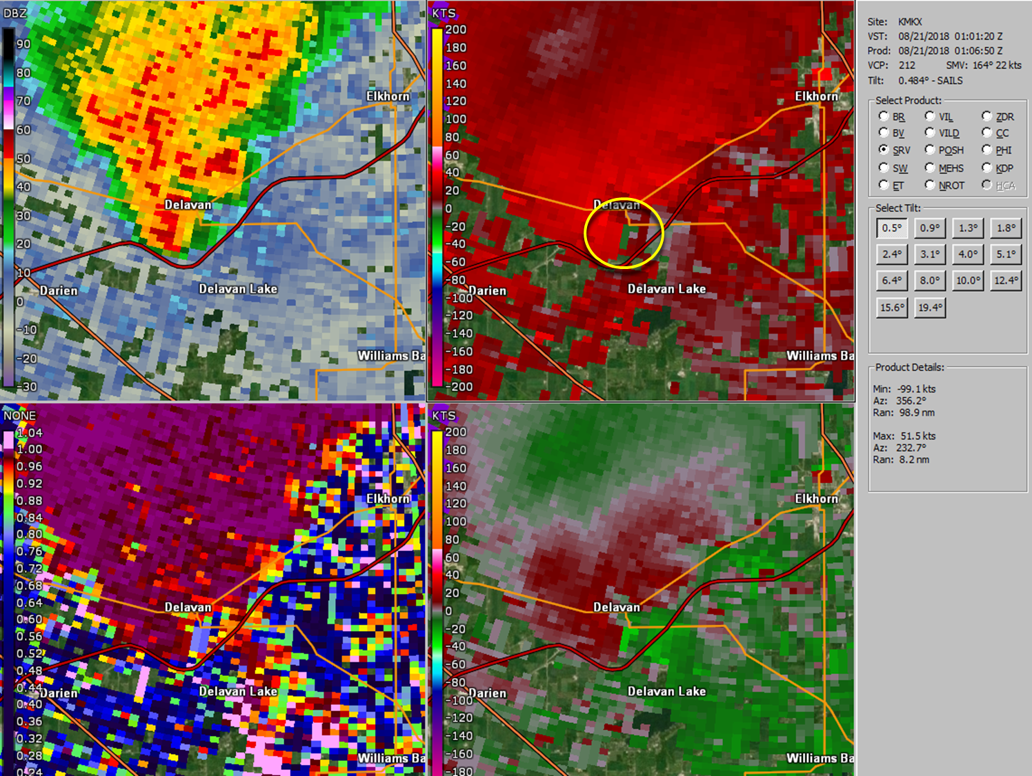
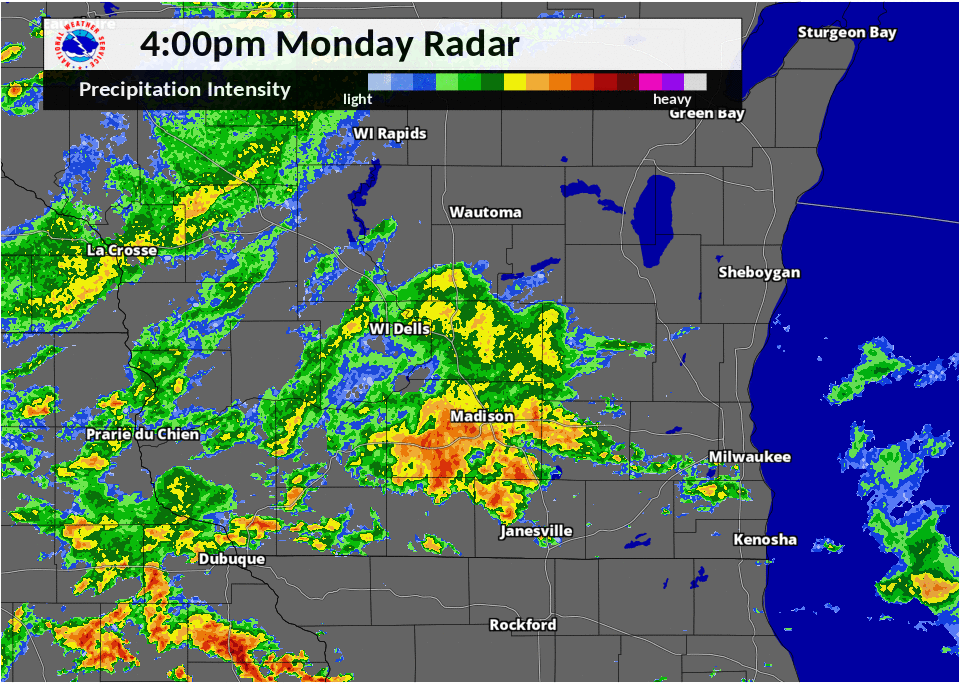
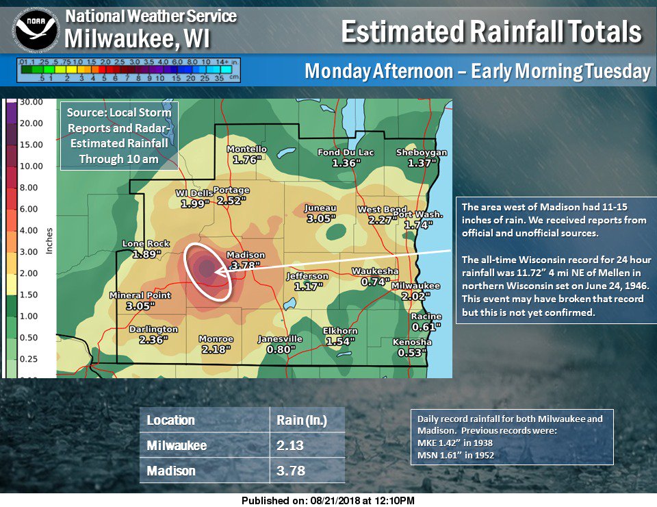
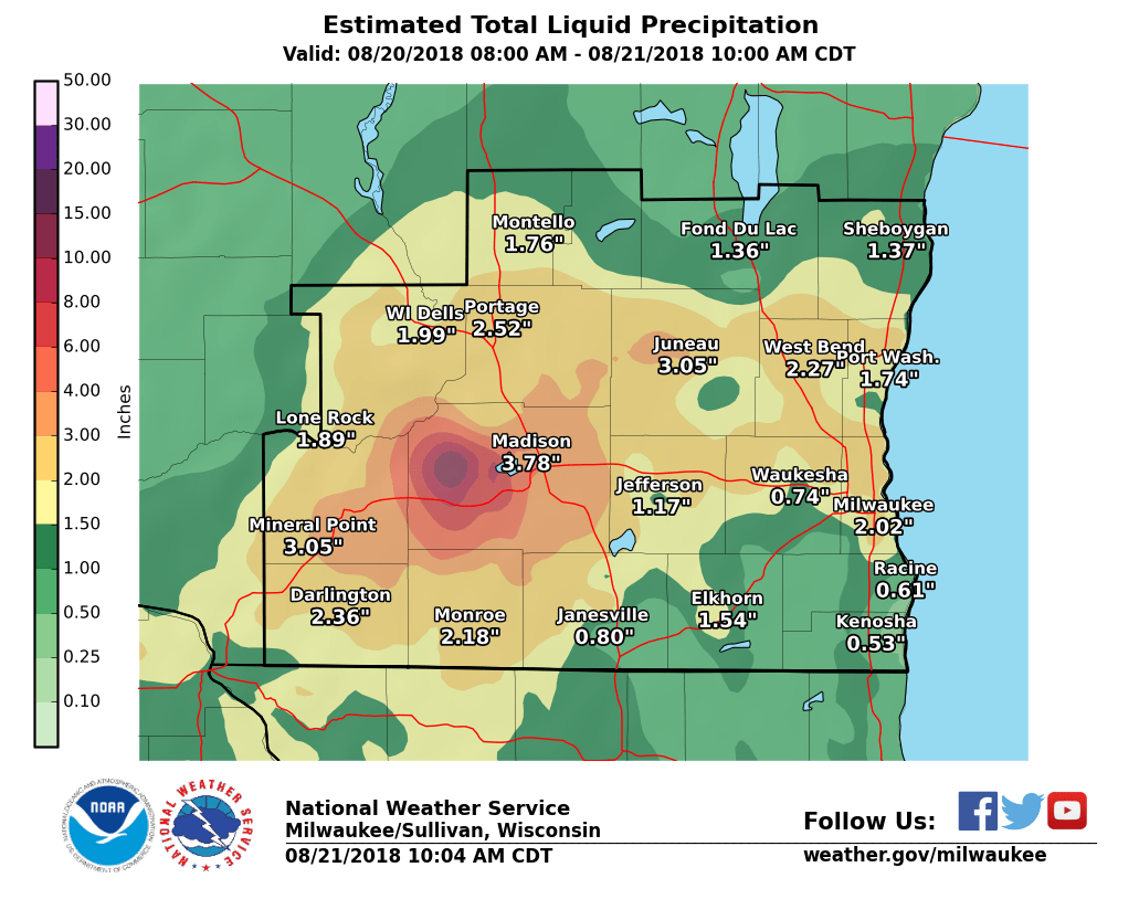
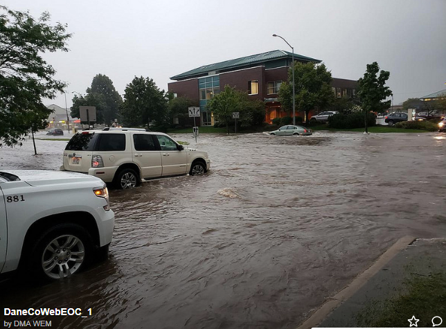
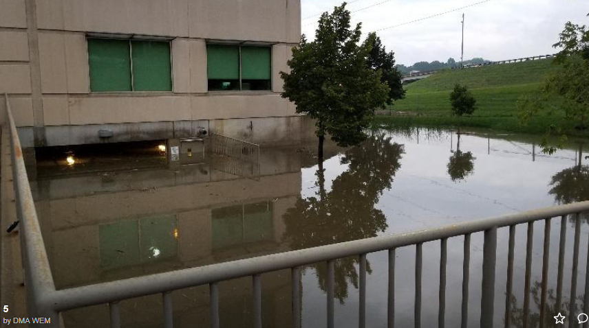
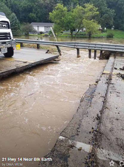
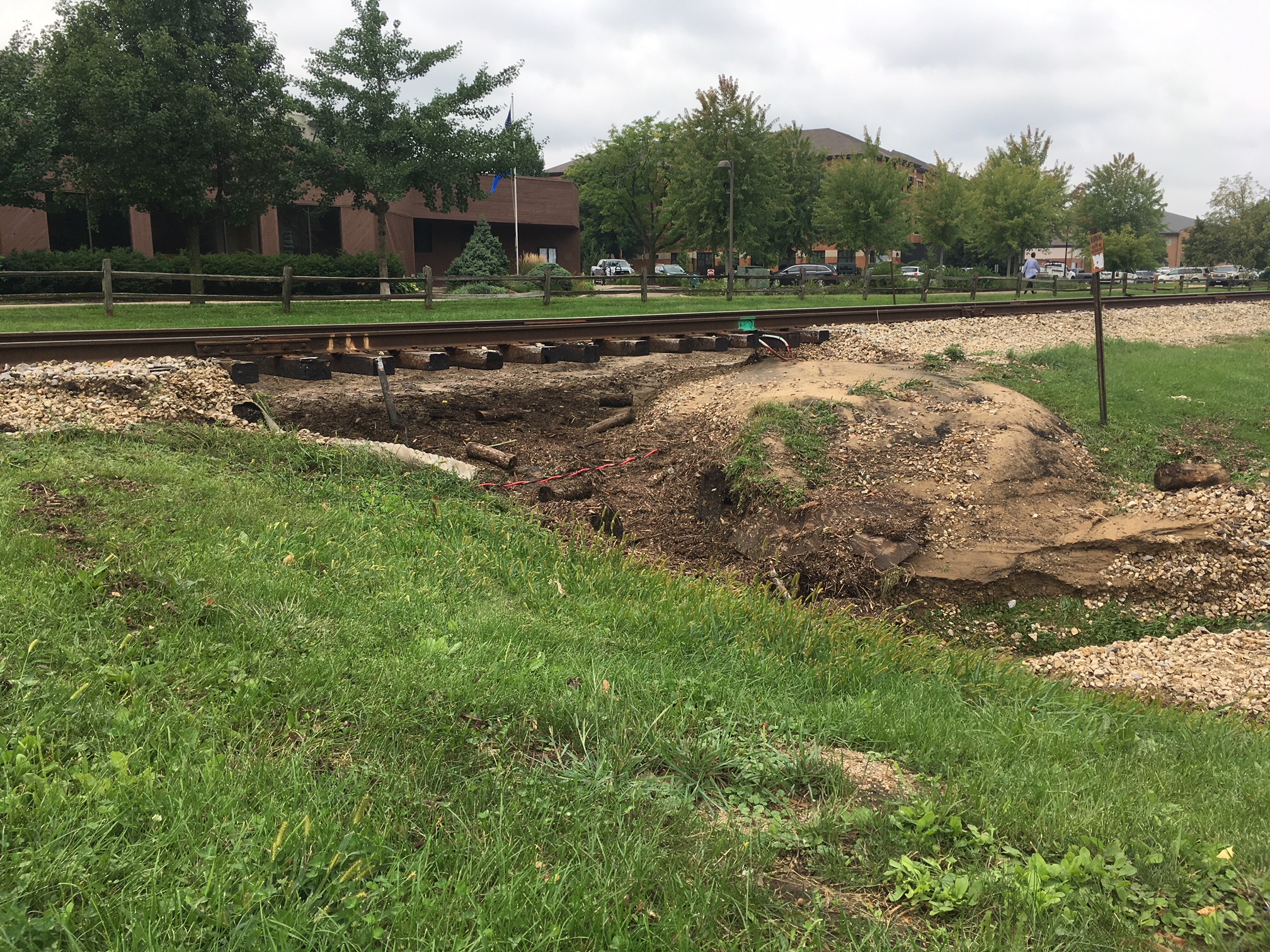
Flooding in Dane County and Delavan Tornado An unseasonably dynamic storm for August affected southern Wisconsin Monday, 8/20 into the morning of Tuesday, 8/21. Torrential rainfall was highest in and around Dane County (particularly west of Madison,WI), where several rainfall measurements exceeded the 10 inch mark. As a result, major flooding has been reported in this area. Across the rest of southern Wisconsin, rainfall reports generally ranged from one half to around two inches. In addition to the rainfall, there was one severe weather report, a brief tornado rated EF-0 was observed in Delavan, WI. |
 Radar Loop |
Tornadoes:
|
Tornado - LOCATION
Track Map 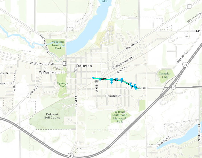 
Downloadable KMZ File |
||||||||||||||||
|
||||||||||||||||
The Enhanced Fujita (EF) Scale classifies tornadoes into the following categories:
| EF0 Weak 65-85 mph |
EF1 Moderate 86-110 mph |
EF2 Significant 111-135 mph |
EF3 Severe 136-165 mph |
EF4 Extreme 166-200 mph |
EF5 Catastrophic 200+ mph |
 |
|||||
Radar / Rainfall:
Header
 |
 |
|
Storm Total Rainfall Estimates |
Measured Rainfall Reports |
 |
 |
 |
 |
| Madison Flooding | Madison Flooding | Madison Flooding | Store Flooding |
 |
 |
 |
 |
| Madison Flooding | Highway 14 Flood Damage | Highway 14 Flood Damage | Shorewood Hills Damage |
Storm Reports
PRELIMINARY LOCAL STORM REPORT...SUMMARY
NATIONAL WEATHER SERVICE MILWAUKEE/SULLIVAN WI
910 PM CDT TUE AUG 21 2018

..TIME...   ...EVENT...      ...CITY LOCATION...     ...LAT.LON...
..DATE...   ....MAG....      ..COUNTY LOCATION..ST.. ...SOURCE....
            ..REMARKS..

0800 AM     HEAVY RAIN       CROSS PLAINS            43.11N 89.65W
08/21/2018  M14.70 INCH      DANE               WI   PUBLIC

            STORM TOTAL.

0920 AM     HEAVY RAIN       CROSS PLAINS            43.11N 89.64W
08/21/2018  M14.33 INCH      DANE               WI   PUBLIC

            CORRECTS PREVIOUS HEAVY RAIN REPORT FROM
            CROSS PLAINS. 24 HOUR RAINFALL TOTAL.

0300 AM     HEAVY RAIN       2 SSW MIDDLETON         43.07N 89.52W
08/21/2018  M13.40 INCH      DANE               WI   PUBLIC

            DIGITAL TIPPING BUCKET GAUGE.

0816 AM     HEAVY RAIN       4 SE CROSS PLAINS       43.07N 89.59W
08/21/2018  M12.97 INCH      DANE               WI   PUBLIC


0900 AM     HEAVY RAIN       1 SSE MIDDLETON         43.09N 89.50W
08/21/2018  M11.93 INCH      DANE               WI   PUBLIC

            DIGITAL TIPPING BUCKET GAUGE.

0700 AM     HEAVY RAIN       1 S MIDDLETON           43.09N 89.50W
08/21/2018  M11.63 INCH      DANE               WI   COCORAHS


1034 PM     HEAVY RAIN       3 W MIDDLETON           43.10N 89.56W
08/20/2018  M11.05 INCH      DANE               WI   PUBLIC


0755 AM     HEAVY RAIN       1 SW MIDDLETON          43.09N 89.52W
08/21/2018  M11.03 INCH      DANE               WI   CO-OP OBSERVER

            MDDW3.

0800 AM     HEAVY RAIN       4 NNE VERONA            43.04N 89.51W
08/21/2018  M11.02 INCH      DANE               WI   COCORAHS

            WI-DA-63.

0700 AM     HEAVY RAIN       6 WNW VERONA            43.03N 89.63W
08/21/2018  M10.47 INCH      DANE               WI   COCORAHS

            WI-DA-49.

1200 PM     HEAVY RAIN       3 SW SHOREWOOD HILLS    43.05N 89.48W
08/21/2018  M10.30 INCH      DANE               WI   PUBLIC

            STORM TOTAL.

1100 PM     HEAVY RAIN       2 S MIDDLETON           43.07N 89.51W
08/20/2018  M10.23 INCH      DANE               WI   COCORAHS


0745 AM     HEAVY RAIN       2 SW SHOREWOOD HILLS    43.06N 89.48W
08/21/2018  M9.62 INCH       DANE               WI   CO-OP OBSERVER

            CHARMANY FARMS - CHMW3.

0700 AM     HEAVY RAIN       4 SSW SHOREWOOD HILLS   43.03N 89.48W
08/21/2018  M9.58 INCH       DANE               WI   COCORAHS

            WI-DA-3.

0637 AM     HEAVY RAIN       3 SW SHOREWOOD HILLS    43.03N 89.47W
08/21/2018  M9.40 INCH       DANE               WI   PUBLIC


0700 AM     HEAVY RAIN       1 W SHOREWOOD HILLS     43.08N 89.47W
08/21/2018  M9.31 INCH       DANE               WI   COCORAHS

            WI-DA-39.

0600 AM     HEAVY RAIN       3 NE VERONA             43.02N 89.49W
08/21/2018  M9.20 INCH       DANE               WI   PUBLIC


0800 AM     HEAVY RAIN       3 NNW FITCHBURG         43.03N 89.45W
08/21/2018  M8.35 INCH       DANE               WI   PUBLIC

            STORM TOTAL.

0700 AM     HEAVY RAIN       1 SSW SHOREWOOD HILLS   43.06N 89.46W
08/21/2018  M8.05 INCH       DANE               WI   COCORAHS

            WI-DA-13.

0705 AM     HEAVY RAIN       1 SSW MIDDLETON         43.09N 89.51W
08/21/2018  M8.05 INCH       DANE               WI   COCORAHS

            WI-DA-60.

0816 AM     HEAVY RAIN       MOUNT HOREB             43.01N 89.73W
08/21/2018  M7.24 INCH       DANE               WI   CO-OP OBSERVER

            MRBW3.

0730 AM     HEAVY RAIN       3 NNE VERONA            43.02N 89.51W
08/21/2018  M6.76 INCH       DANE               WI   PUBLIC

            STORM TOTAL.

0700 AM     HEAVY RAIN       3 NNE VERONA            43.03N 89.51W
08/21/2018  E6.76 INCH       DANE               WI   COCORAHS


0630 AM     HEAVY RAIN       1 N NEW GLARUS          42.83N 89.63W
08/21/2018  M5.92 INCH       GREEN              WI   TRAINED SPOTTER


1030 AM     HEAVY RAIN       DEERFIELD               43.05N 89.08W
08/21/2018  M4.90 INCH       DANE               WI   PUBLIC

            STORM TOTAL.

0800 AM     HEAVY RAIN       3 N MAPLE BLUFF         43.16N 89.37W
08/21/2018  M4.84 INCH       DANE               WI   COCORAHS

            COCORAHS STATION WI-DA-35, 3 N MAPLE BLUFF.

0800 AM     HEAVY RAIN       2 ENE MAPLE BLUFF       43.12N 89.32W
08/21/2018  M4.58 INCH       DANE               WI   COCORAHS

            COCORAHS STATION WI-DA-56, 2 ENE MAPLE
            BLUFF.

0700 AM     HEAVY RAIN       OREGON                  42.92N 89.39W
08/21/2018  M4.24 INCH       DANE               WI   COCORAHS

            COCORAHS STATION WI-DA-33, OREGON.

1151 AM     HEAVY RAIN       2 SW MADISON            43.06N 89.40W
08/21/2018  M4.23 INCH       DANE               WI   PUBLIC

            AUTOMATED TIPPING BUCKET GAUGE....STORM
            TOTAL.

0800 AM     HEAVY RAIN       NEW GLARUS              42.81N 89.63W
08/21/2018  M4.23 INCH       GREEN              WI   CO-OP OBSERVER

            NGLW3.

1030 AM     HEAVY RAIN       1 S BROWN DEER          43.17N 87.98W
08/21/2018  M4.20 INCH       MILWAUKEE          WI   TRAINED SPOTTER

            STORM TOTAL.

0730 AM     HEAVY RAIN       DEERFIELD               43.06N 89.07W
08/21/2018  M4.20 INCH       DANE               WI   COCORAHS

            COCORAHS STATION WI-DA-31, DEERFIELD.

0600 AM     HEAVY RAIN       1 E MAPLE BLUFF         43.11N 89.35W
08/21/2018  M4.14 INCH       DANE               WI   COCORAHS

            COCORAHS STATION WI-DA-52, 1 E MAPLE BLUFF.

0700 AM     HEAVY RAIN       BARNEVELD 1 S           43.00N 89.89W
08/21/2018  M4.10 INCH       IOWA               WI   CO-OP OBSERVER

            CO-OP OBSERVER STATION BLDW3, BARNEVELD 1 S.

0930 AM     HEAVY RAIN       1 SSW SUN PRAIRIE       43.17N 89.24W
08/21/2018  M4.05 INCH       DANE               WI   MESONET

            MESONET STATION E4463, 1 SSW SUN PRAIRIE.

0608 AM     HEAVY RAIN       SAUK CITY               43.26N 89.74W
08/21/2018  M4.05 INCH       SAUK               WI   CO-OP OBSERVER

            CO-OP OBSERVER STATION SACW3, SAUK CITY.

0700 AM     HEAVY RAIN       BROOKLYN                42.86N 89.36W
08/21/2018  M4.02 INCH       DANE               WI   COCORAHS

            COCORAHS STATION WI-DA-44, BROOKLYN.

0830 AM     HEAVY RAIN       LONDON                  43.05N 89.01W
08/21/2018  E4.00 INCH       DANE               WI   PUBLIC

            STORM TOTAL.

0800 AM     HEAVY RAIN       PIPERSVILLE             43.14N 88.65W
08/21/2018  M4.00 INCH       JEFFERSON          WI   PUBLIC

            STORM TOTAL.

0455 AM     HEAVY RAIN       OREGON                  42.92N 89.39W
08/21/2018  M3.97 INCH       DANE               WI   MESONET

            MESONET STATION C5917, OREGON.

0653 AM     HEAVY RAIN       MADISON-DANE COUNTY AIR 43.14N 89.34W
08/21/2018  M3.92 INCH       DANE               WI   ASOS

            ASOS STATION MSN, MADISON-DANE COUNTY
            AIRPORT.

0820 AM     HEAVY RAIN       WINDSOR                 43.22N 89.34W
08/21/2018  M3.91 INCH       DANE               WI   TRAINED SPOTTER

            STORM TOTAL.

0700 AM     HEAVY RAIN       4 SW DANE               43.20N 89.55W
08/21/2018  M3.70 INCH       DANE               WI   COCORAHS

            COCORAHS STATION WI-DA-62, 4 SW DANE.

0700 AM     HEAVY RAIN       5 SE DODGEVILLE         42.91N 90.06W
08/21/2018  M3.56 INCH       IOWA               WI   COCORAHS

            COCORAHS STATION WI-IW-3, 5 SE DODGEVILLE.

0700 AM     HEAVY RAIN       3 WSW SUN PRAIRIE       43.17N 89.29W
08/21/2018  M3.56 INCH       DANE               WI   COCORAHS

            COCORAHS STATION WI-DA-65, 3 WSW SUN
            PRAIRIE.

0830 AM     HEAVY RAIN       BEAVER DAM 1 N          43.47N 88.84W
08/21/2018  M3.53 INCH       DODGE              WI   CO-OP OBSERVER

            CO-OP OBSERVER STATION BDMW3, BEAVER DAM 1
            N.

0700 AM     HEAVY RAIN       1 SW BEAVER DAM         43.45N 88.85W
08/21/2018  M3.50 INCH       DODGE              WI   COCORAHS

            COCORAHS STATION WI-DD-4, 1 SW BEAVER DAM.

0700 AM     HEAVY RAIN       BEAVER DAM              43.45N 88.85W
08/21/2018  M3.47 INCH       DODGE              WI   CO-OP OBSERVER

            CO-OP OBSERVER STATION BEAW3, BEAVER DAM.

0700 AM     HEAVY RAIN       1 ESE BELLEVILLE        42.85N 89.51W
08/21/2018  M3.43 INCH       GREEN              WI   COCORAHS

            COCORAHS STATION WI-GN-7, 1 ESE BELLEVILLE.

0655 AM     HEAVY RAIN       DODGE COUNTY APT        43.43N 88.70W
08/21/2018  M3.37 INCH       DODGE              WI   AWOS

            AWOS STATION UNU, DODGE COUNTY APT.

0700 AM     HEAVY RAIN       1 W KEWASKUM            43.53N 88.27W
08/21/2018  M3.24 INCH       WASHINGTON         WI   COCORAHS

            COCORAHS STATION WI-WS-4, 1 W KEWASKUM.

0700 AM     HEAVY RAIN       WINDSOR                 43.23N 89.35W
08/21/2018  M3.23 INCH       DANE               WI   COCORAHS

            COCORAHS STATION WI-DA-64, WINDSOR.

0700 AM     HEAVY RAIN       STOUGHTON               42.92N 89.22W
08/21/2018  M3.22 INCH       DANE               WI   CO-OP OBSERVER

            CO-OP OBSERVER STATION STOW3, STOUGHTON.

0600 AM     HEAVY RAIN       COTTAGE GROVE           43.09N 89.22W
08/21/2018  M3.18 INCH       DANE               WI   COCORAHS

            COCORAHS STATION WI-DA-20, COTTAGE GROVE.

0631 AM     HEAVY RAIN       1 ESE GERMANTOWN        43.23N 88.11W
08/21/2018  M3.16 INCH       WASHINGTON         WI   TRAINED SPOTTER


0655 AM     HEAVY RAIN       ARGYLE                  42.70N 89.02W
08/21/2018  M3.04 INCH       ROCK               WI   CO-OP OBSERVER

            CO-OP OBSERVER STATION ARGW3, ARGYLE.

0600 AM     HEAVY RAIN       3 SSW RICHRIELD         43.21N 88.21W
08/21/2018  M3.03 INCH       WASHINGTON         WI   CO-OP OBSERVER

            CO-OP OBSERVER STATION RCHW3, 3 SSW
            RICHRIELD.

0700 AM     HEAVY RAIN       MCFARLAND               43.02N 89.28W
08/21/2018  M3.02 INCH       DANE               WI   COCORAHS

            COCORAHS STATION WI-DA-14, MCFARLAND.
 |
Media use of NWS Web News Stories is encouraged! Please acknowledge the NWS as the source of any news information accessed from this site. |
|