
Catastrophic Super Typhoon Bavi's eyewall has reached Rota and is expected to bring dangerous winds, heavy rainfall and storm surge to Guam, Rota, Tinian and Saipan. A Typhoon Warning remains in effect. Heavy to excessive rainfall will continue to bring a flooding threat from coastal Mid-Atlantic to southern New England through Monday. Read More >
Overview
|
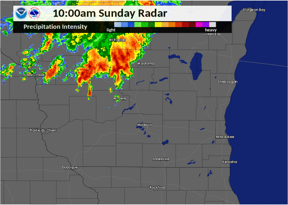
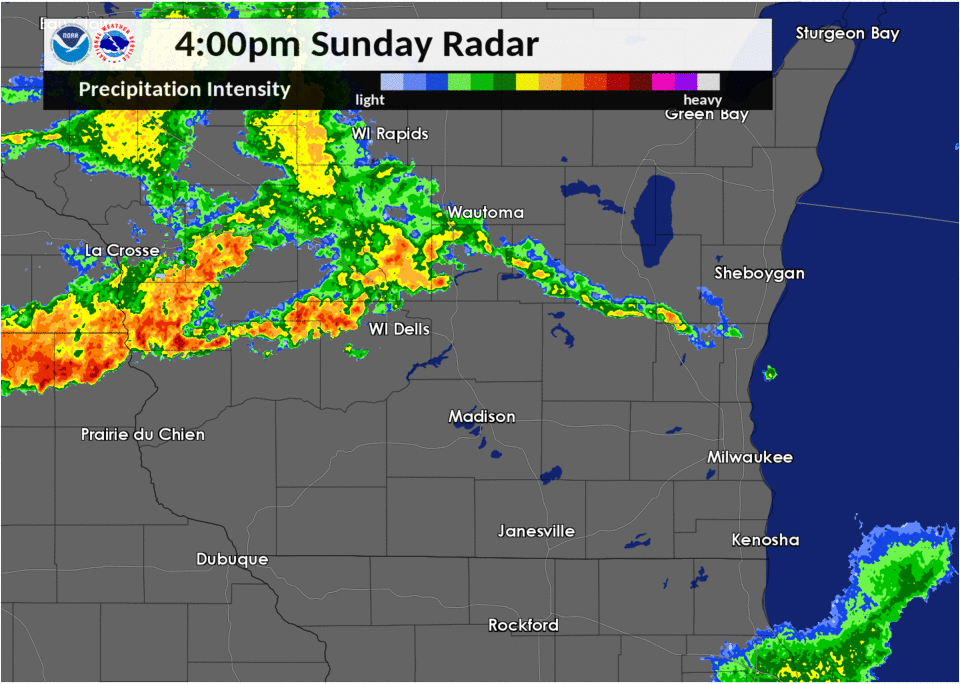
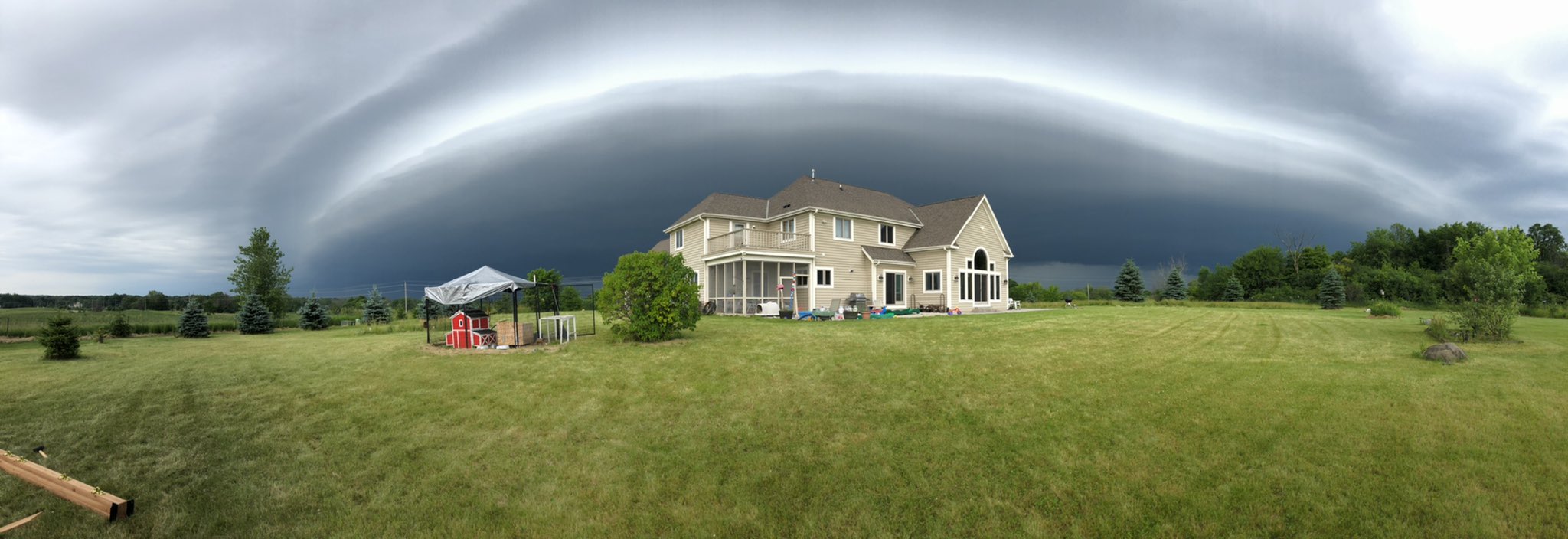
It was an active day across southern Wisconsin on Sunday, June 30, 2019! A line of strong to severe thunderstorms arrived during the mid to late morning, pushed across all of southern Wisconsin, then exited south into Illinois by early afternoon. A second line of storms developed over west central Wisconsin during the mid afternoon and pushed south down the Mississippi River, bringing strong and damaging winds to Lafayette county, southwest of Madison. |
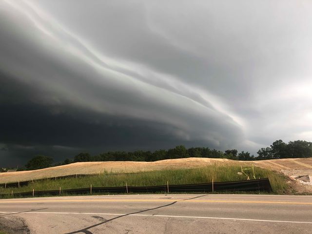 Hartland - Jeff Semrad |
Wind:
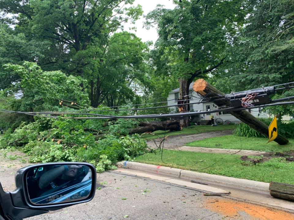
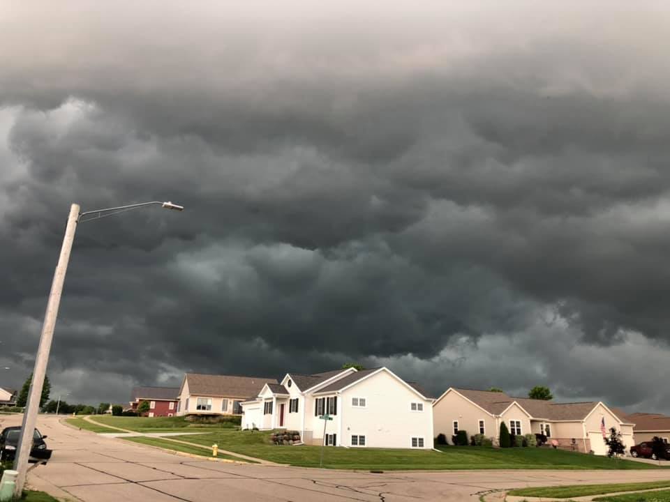
Although there was some hail reported with the storms, this was primarily a straight-line wind event day. Many locations reported trees down/damage. Many lost power. The first line of storms entered our forecast around around 10 am and exited south into Illinois by 2 pm. The second line pushed into Sauk County just after 4 pm and moved south into Illinois by around 6 pm. All pictures below are from the first line of storms.
Wind
.
 |
 |
 |
 |
| First Line Of Severe Storms | Second Line Of Severe Storms | Ashippun - Tricia Logue | Oconomowoc - Jessica Godfroy |
 |
 |
 |
 |
| Oconomowoc - Rachel Kaye | Allenton - Jake Stehli | Mequon - Alex Hallam | Columbus - Rod Melotte |
Storm Reports
PRELIMINARY LOCAL STORM REPORT...SUMMARY
NATIONAL WEATHER SERVICE MILWAUKEE/SULLIVAN WI
235 PM CDT SUN JUN 30 2019

..TIME...   ...EVENT...      ...CITY LOCATION...     ...LAT.LON...
..DATE...   ....MAG....      ..COUNTY LOCATION..ST.. ...SOURCE....
            ..REMARKS..

0119 PM     HEAVY RAIN       1 W DELAFIELD           43.06N 88.42W
06/30/2019  M1.58 INCH       WAUKESHA           WI   PUBLIC


0117 PM     HEAVY RAIN       1 S WATERTOWN           43.18N 88.72W
06/30/2019  M0.94 INCH       JEFFERSON          WI   PUBLIC


0103 PM     TSTM WND DMG     1 SSW PADDOCK LAKE      42.55N 88.11W
06/30/2019                   KENOSHA            WI   PUBLIC

            TREES DOWN ACROSS THE ROAD.

0103 PM     TSTM WND GST     SILVER LAKE             42.55N 88.16W
06/30/2019  M58 MPH          KENOSHA            WI   TRAINED SPOTTER

            NUMEROUS LARGE TREES UPROOTED AND SNAPPED IN
            HALF. NUMEROUS POWER LINES DOWN.

1253 PM     TSTM WND DMG     1 W GENOA CITY          42.50N 88.34W
06/30/2019                   WALWORTH           WI   PUBLIC

            WIND DAMAGED A TRANSFORMER IN THE AREA NEAR
            RIDGEVIEW DRIVE AND COUNTY ROAD B.

1250 PM     TSTM WND DMG     3 NNW SILVER LAKE       42.60N 88.18W
06/30/2019                   KENOSHA            WI   PUBLIC

            SEVERAL TREE BRANCHES DOWN.

1242 PM     TSTM WND GST     3 N NEW BERLIN          43.01N 88.13W
06/30/2019  E50 MPH          WAUKESHA           WI   TRAINED SPOTTER


1240 PM     TSTM WND DMG     PELL LAKE               42.54N 88.36W
06/30/2019                   WALWORTH           WI   PUBLIC

            LARGE TREE LIMBS DOWN. ESTIMATED 60 MPH
            GUSTS.

1230 PM     TSTM WND DMG     5 NNE MUKWONAGO         42.93N 88.30W
06/30/2019                   WAUKESHA           WI   TRAINED SPOTTER

            LARGE TREE DOWN.

1228 PM     TSTM WND DMG     DOUSMAN                 43.01N 88.47W
06/30/2019                   WAUKESHA           WI   PUBLIC

            LARGE BRANCHES SNAPPED OFF.

1225 PM     TSTM WND DMG     FONTANA-ON-GENEVA       42.55N 88.57W
06/30/2019                   WALWORTH           WI   911 CALL CENTER

            TREE DAMAGE THROUGHOUT THE COUNTY. FONTANA
            IS ONE OF THE HARD HIT AREAS.

1225 PM     TSTM WND DMG     DELAVAN                 42.63N 88.63W
06/30/2019                   WALWORTH           WI   911 CALL CENTER

            TREE DAMAGE THROUGHOUT THE COUNTY. DELAVAN
            IS ONE HARD HIT AREA.

1200 PM     TSTM WND DMG     1 ENE OCONOMOWOC        43.11N 88.49W
06/30/2019                   WAUKESHA           WI   PUBLIC

            WIDESPREAD WIND DAMAGE IN WAUKESHA COUNTY
            ESPECIALLY IN THE OCONOMOWOC AREA.

1200 PM     TSTM WND DMG     1 ESE HARTFORD          43.32N 88.37W
06/30/2019                   WASHINGTON         WI   PUBLIC

            LARGE TREE BRANCH DOWN.

1155 AM     TSTM WND DMG     1 SW LAC LA BELLE       43.13N 88.53W
06/30/2019                   WAUKESHA           WI   PUBLIC

            TWO LARGE TREE BRANCHES DOWN.

1145 AM     TSTM WND DMG     IXONIA                  43.15N 88.59W
06/30/2019                   JEFFERSON          WI   PUBLIC

            WIDESPREAD WIND DAMAGE THROUGHOUT THE COUNTY
            PARTICULARLY IN THE IXONIA AREA.

1142 AM     TSTM WND DMG     5 N LAC LA BELLE        43.21N 88.52W
06/30/2019                   DODGE              WI   PUBLIC

            SIDING BLOWN OFF OF A HOUSE IN ASHIPPUN.

1140 AM     TSTM WND GST     1 SSW WATERTOWN         43.18N 88.73W
06/30/2019  M58 MPH          JEFFERSON          WI   COCORAHS

            .

1135 AM     TSTM WND GST     2 N JUNEAU              43.43N 88.70W
06/30/2019  M50 MPH          DODGE              WI   AWOS

            .

1135 AM     TSTM WND DMG     HORICON                 43.45N 88.64W
06/30/2019                   DODGE              WI   LAW ENFORCEMENT

            TREES DOWN ACROSS THE AREA.

1135 AM     TSTM WND DMG     1 ENE SUN PRAIRIE       43.19N 89.22W
06/30/2019                   DANE               WI   PUBLIC

            TREES DOWN.

1130 AM     TSTM WND DMG     JUNEAU                  43.41N 88.71W
06/30/2019                   DODGE              WI   LAW ENFORCEMENT

            HWY 26 LARGE TREE DOWN BLOCKING ROAD.

1125 AM     TSTM WND DMG     6 SE CLYMAN             43.26N 88.63W
06/30/2019                   DODGE              WI   PUBLIC

            TWO YOUNG TREES SNAPPED AT THEIR BASE.

1125 AM     HAIL             ARENA                   43.16N 89.91W
06/30/2019  M0.70 INCH       IOWA               WI   PUBLIC

            RELAYED BY WKOW.

1116 AM     TSTM WND DMG     LAKE DELTON             43.59N 89.78W
06/30/2019                   SAUK               WI   911 CALL CENTER

            SCATTERED TREES DOWN WITH SOME BEING LARGE.

1115 AM     TSTM WND GST     1 NE COLUMBUS           43.34N 89.02W
06/30/2019  M52 MPH          COLUMBIA           WI   PUBLIC

            SOCIAL MEDIA MEASURED WITH ANEMOMETER.

1100 AM     TSTM WND DMG     POYNETTE                43.39N 89.40W
06/30/2019                   COLUMBIA           WI   911 CALL CENTER

            SCATTERED TREES DOWN.

1050 AM     TSTM WND DMG     WYOCENA                 43.50N 89.31W
06/30/2019                   COLUMBIA           WI   911 CALL CENTER

            WIDESPREAD TRESS DOWN.

1040 AM     TSTM WND DMG     PORTAGE                 43.54N 89.46W
06/30/2019                   COLUMBIA           WI   911 CALL CENTER

            WIDESPREAD TREES DOWN WITH SOME BEING LARGE.

1040 AM     TSTM WND DMG     MONTELLO                43.79N 89.32W
06/30/2019                   MARQUETTE          WI   911 CALL CENTER

            CORRECTS PREVIOUS TSTM WND DMG REPORT FROM
            MONTELLO. SCATTERED TREES DOWN THROUGHOUT
            THE COUNTY.

1030 AM     TSTM WND DMG     1 ENE PRAIRIE DU SAC    43.30N 89.71W
06/30/2019                   COLUMBIA           WI   911 CALL CENTER

            SCATTERED TREES DOWN WITH A FEW LARGE TREES.

1030 AM     TSTM WND DMG     1 NNE BARABOO           43.48N 89.74W
06/30/2019                   SAUK               WI   911 CALL CENTER

            SCATTERED TREES DOWN WITH A FEW LARGE TREES.

1025 AM     TSTM WND DMG     ENDEAVOR                43.72N 89.47W
06/30/2019                   MARQUETTE          WI   LAW ENFORCEMENT

            WIND BRANCHES DOWN. ESTIMATED 50-60MPH
            GUSTS.

1020 AM     TSTM WND DMG     LAKE DELTON             43.59N 89.78W
06/30/2019                   SAUK               WI   911 CALL CENTER

            CORRECTS PREVIOUS TSTM WND DMG REPORT FROM
            LAKE DELTON. SCATTERED TREES DOWN WITH SOME
            BEING LARGE.
 |
Media use of NWS Web News Stories is encouraged! Please acknowledge the NWS as the source of any news information accessed from this site. |
|

