 |
| About This Page |
| Arkansas has had its share of historic events, many of which will be in our memories for years to come. |
|
|
 |
Destructive Tornadoes on December 10-11, 2021 |
 |
| |
|
|
| |
|
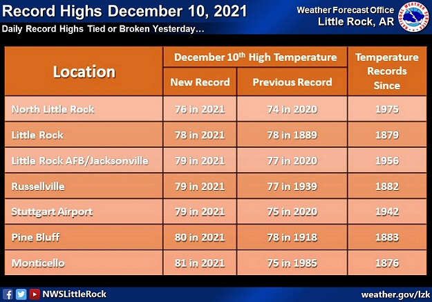
Well above normal temperatures occurred on December 10th, and it felt a lot more like spring than winter. Readings across Arkansas peaked in the mid 70s to lower 80s. A cold front surged through the state during the overnight hours, and temperatures dropped into the lower 30s to mid 40s (falling 35 to 45 degrees). Such a contrast in air masses often leads to severe weather, and that's what happened...in a big way.
|
 |
| In the picture: Several record high temperatures were tied or broken on 12/10/2021. Some of the previous records were set more than a century ago. |
|
| |
|
Thunderstorms held off until the late afternoon, and that allowed the temperature at Pine Bluff (Jefferson County) to climb to 80 degrees. This broke the previous high mark of 78 degrees set in 1918. At Little Rock (Pulaski County), the mercury reached 78 degrees which tied the record established in 1889!
|
 |
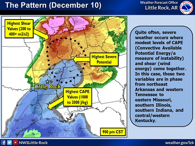
| In the picture: Severe weather was most likely where modest levels of CAPE (Convective Available Potential Energy/a measure of instability) and shear (wind energy to force storm development/drive storms/create rotation) came together. This happened from northeast Arkansas and western Tennessee to eastern Missouri, southern Illinois, southern Indiana, and central/western Kentucky. |
|
| |
|
Warmth and moisture ahead of the front destabilized the atmosphere, and made it easier for thunderstorms to pop up. A powerful storm system associated with the front had a lot of wind energy to help kick storms into gear, move them swiftly, and cause them to rotate. It was a recipe for disaster.
|
|
|
| In the video: The satellite showed thunderstorms erupting from parts of the mid-Mississippi, Ohio, and Tennessee Valleys into Arkansas during the late afternoon and evening of 12/10/2021. |
|
| |
|
In Arkansas, an isolated thunderstorm began growing in central sections of the state between 400 pm and 500 pm CST, and headed rapidly (50 to 60 mph) to the northeast. Shortly before 600 pm CST, the storm was just west of Augusta (Woodruff County), and a Tornado Warning was issued. A storm chaser provided video proof of a tornado and found tree debris on Highway 17 north of Weldon (Jackson County). Tornado sightings and more Tornado Warnings followed near Weiner (Poinsett County), south of Jonesboro (Craighead County), and northwest of Bay (Craighead County). A large rice factory was damaged. From there, it got progressively worse.
|
|
|
| In the video: A tornado ripped through Leachville (Mississippi County) in northeast Arkansas on 12/10/2021. A fatality occurred at a discount store that was flattened. The video is courtesy of Brian Emfinger via Twitter. |
|
| |
|
A nursing home at Monette (Craighead County) took a direct hit from a tornado and one resident died. At least twenty people were trapped, and there were several injuries. A discount store was flattened at Leachville (Mississippi County), and this resulted in a fatality.
|
 |
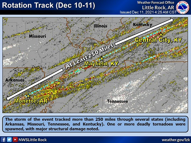
| In the picture: The storm of the event tracked more than 250 miles through several states (including Arkansas, Missouri, Tennessee, and Kentucky). Two deadly tornadoes were spawned, with major structural damage noted. |
|
| |
|
In the end, the storm spawned five tornadoes in northeast Arkansas. The first four of these were brief and weak (rated EF0/EF1), with the fifth tornado (rated EF4) wreaking havoc for 80 miles into southeast Missouri and northwest Tennessee. A second seemingly endless tornado (rated EF4) went on a 164 mile rampage through western and central Kentucky. Both long track tornadoes were deadly and caused massive destruction.
|
| Almost Making History |
|
The storm of this event showed persistent rotation (making it a supercell), and was all by itself ahead of other storms that eventually developed to the west. Storms like this are very dangerous because they can feed on unstable air without disruption, and can last for hours. In rare instances, they can crank out tornadoes that stay on the ground for more than a hundred miles. There was a real chance that this storm had a tornado that persisted longer than the historic and unprecedented Tri-State Tornado of March 18, 1925 (219 miles through Missouri, Illinois, and Indiana).
Ultimately, a small void in damage was found between Samburg, TN (Reelfoot Lake) and Cayce, KY. Instead of one long continuous tornado, there were two tornadoes. Track number one (rated EF4) went from northeast Arkansas through southeast Missouri and northwest Tennessee (80 miles). Track number two (rated EF4) extended across western and central Kentucky (164 miles).
|
|
|
| |
|
The town of Mayfield, KY was hit particularly hard. Many buildings were heavily damaged or destroyed, including a large candle factory that was completely dismantled. At least eight people were killed at the factory. Across Kentucky, reports indicated the storm was to blame for over seventy five fatalities. Hundreds of citizens were without homes. Given so much real estate to cover, it was certain to take days to figure out how many tornadoes were involved and assign ratings (through damage surveys).
|
|
Monster storms are often accompanied by stories of disbelief and hope, and this was no different. For example, an hour after Mayfield, KY was changed forever, the town of Dawson Springs, KY was clobbered. An old black and white photo from the town was found on a windshield 130 miles away in New Albany, IN. Social media helped reunite the affected family with the photo. Just to the east in Muhlenberg County, KY, a man played a water damaged piano in what was left of his home to somehow bring peace to an otherwise chaotic situation.
Elsewhere, a warehouse was torn apart by a tornado (rated EF3) in Edwardsville, IL. Half a dozen people lost their lives.
|
| One for the Record Books |
|
This event was the most impactful from northeast Arkansas into portions of Missouri, Illinois, Kentucky, and Tennessee. An incredible five dozen tornadoes were counted, and eight of these were rated EF3 or higher. Across the country, this was the deadliest tornado episode on record: (1) in December (90+ fatalities), and (2) since April/May, 2011.
|
|
|
| |
|
Back at home, there were seven additional tornadoes between 800 pm and 930 pm CST. Two of these were weak (rated EF1) on the north side of Diaz (Jackson County) and northeast of Cash (Craighead County). A new storm unleashed a stronger tornado (rated EF2/an 8.6 mile track) from just north of Augusta (Woodruff County) to south of Tupelo (Jackson County). Homes and farm buildings were roughed up, and there were three injuries. A short time later, the same storm dropped a quick tornado (rated EF1) to the southwest of Beedeville (Jackson County).
|
|
Unfortunately, the storm was not finished. Two weak tornadoes (rated EF0) were tallied between Fisher and Harrisburg (both in Poinsett County), and a more significant tornado (rated EF2) pounded homes and businesses at Trumann (Craighead County).
Later on, it appears the same storm was responsible for a 100 mile tornado (rated EF3) that ravaged areas from northeast of Dyersburg, TN to southeast of Hopkinsville, KY. If that was not enough, it spun up a tornado (rated EF3) at Bowling Green, KY between 100 am and 130 am CST on the 11th that resulted in 15+ deaths.
|
| How Many Tornadoes in Arkansas? |
|
Twelve tornadoes were confirmed in northeast Arkansas. The tornadoes were in Craighead, Jackson, Mississippi, Poinsett, and Woodruff Counties. The strongest of these by far (rated EF4) was on the ground from north of Bay (Craighead County) to a few miles north of Poplar Corner (Mississippi County) before going into Missouri and Tennessee.
|
 |
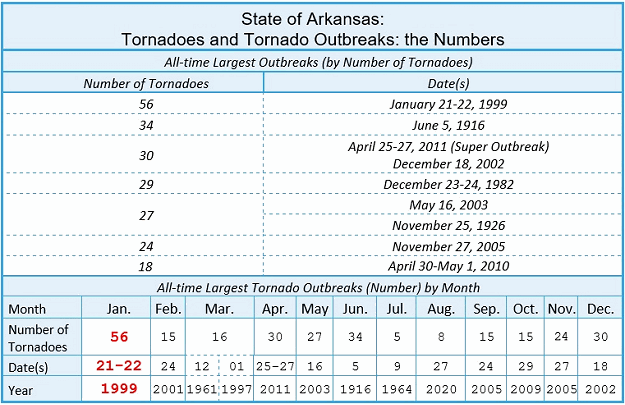
| In the picture: Half of the largest tornado outbreaks in Arkansas occurred during the fall and winter months (September through February). |
|
| |
|
This event was a reminder that big tornado episodes can happen outside of spring. Many folks associate tornadoes with the months of March through May, and plenty of tornadoes have been counted during this time frame. However, just like warm and cold air masses collide in spring, the same happens in fall/winter, especially when roller coaster temperatures are observed.
|
|
|
| In the picture: Severe weather reports in the twenty four hour period ending at 600 am CST on 12/11/2021. The graphic is courtesy of the Storm Prediction Center. |
|
| |
|
While tornadoes were touching down in the northeast, the rest of the state had damaging winds and hail here and there. Straight-line winds rolled a mobile home just west of Osceola (Mississippi County), and derailed twenty train cars southeast of Marion (Crittenden County). Trees were toppled at Okolona (Clark County), Poyen (Grant County), Tulip (Dallas County), between Foreman and Ashdown (Little River County), and north of Emerson (Columbia County). There was a 64 mph gust measured at the Little Rock Air Force Base (Pulaski County). Gusts reached 60 mph near Ozark (Franklin County), and at Caulksville and Paris (both in Logan County). Half dollar size hail pelted Blevins (Hempstead County) and Ward (Lonoke County). Quarter size stones were reported at Mountain Pine (Garland County), Gibson (Pulaski County), Prescott (Nevada County), and Arkadelphia (Clark County). Similar hail fell at Cabot (Lonoke County), and heavy rain flooded roads.
|
|
|
| In the picture: Twenty four hour rainfall through 600 am CST on 12/11/2021. |
|
| |
|
Rain was hit and miss across the region. Parts of the southeast half of the state had over an inch of precipitation, while some locations in the north/west had little to no liquid. Twenty four hour amounts as of 600 am CST on the 11th included 1.81 inches at Antoine (Pike County), 1.70 inches at Cabot (Lonoke County), 1.51 inches at Conway (Faulkner County), and 1.43 inches at Crystal Valley and North Little Rock (both in Pulaski County).
|
| Historic Derecho to the North |
|
A few days after this event (on the 15th), a rare December derecho (long lived damaging wind producing line of storms) manufactured greater than hurricane force wind gusts (including a 93 mph gust at Lincoln, NE) from Nebraska into Iowa, southern Minnesota, and western Wisconsin. More than 90 tornadoes (rated EF0 to EF2) occurred along the way, including first ever December tornadoes in Minnesota. Prior to the storms, high winds kicked up dust and fanned wildfires from Colorado into Kansas.
|
|
|
There were several reports of damaging winds, large hail, isolated tornadoes, and flash flooding on December 10th/11th (early). For a look at the reports, click here.
|
| In the picture: Preliminary reports of severe weather and flash flooding in the Little Rock County Warning Area on December 10-11, 2021 (in red). |
| |
|
|