 |
| Yearly Reports |
| Interested in what kind of weather occurred in a recent year? Check out the most memorable events below. |
|
|
 |
Arkansas Yearly Climate Summary (2016)/Pg2 |
 |
| |
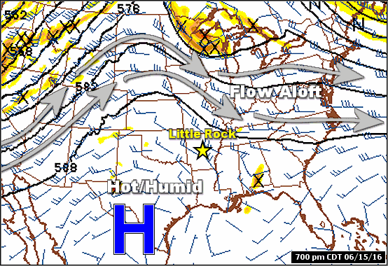 |
| In the picture: The pattern featured a ridge of high pressure ("H") over the southern Plains, with the flow aloft (that drives storm systems and fronts) moving around the periphery of the ridge in mid-June, 2016. |
|
| |
| It certainly felt like summer in mid-June as a ridge of high pressure built over the region. Under the ridge, it was hot and rain was spotty. |
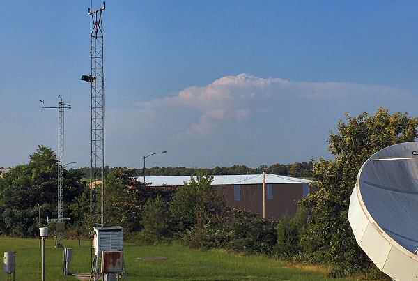 |
| In the pictures: A severe storm near Batesville (Independence County) was visible from 60 to 70 miles away at North Little Rock (Pulaski County) on 06/15/2016. |
|
| |
|
When isolated storms managed to pop up, they were visible for miles. One such storm hit areas between Batesville (Independence County) and Pleasant Plains (Independence/White County line) on the 15th. Golfball to baseball size hail was reported, and two to three inches of rain fell in an hour. There was also a lot of lightning, which was witnessed by many people. There were numerous posts about the storm in social media.
|
|
|
| In the picture: Severe weather reports on June 22-23, 2016. The graphic is courtesy of the Storm Prediction Center. |
|
| |
|
Storms were more widespread around the periphery of high pressure. On the 22nd/23rd, there was not much happening in Arkansas with high temperatures in the 90s. Meanwhile, severe storms produced widespread wind damage and isolated tornadoes from Illinois to North Carolina.
|
| Flooding in West Virginia |
|
In late June, there was torrential rain in West Virginia. Over eight inches of liquid fell in places, moving from higher terrain into the valleys and filling rivers/streams in a hurry. An historic flood event unfolded, with some tributaries reaching the highest levels in recorded history. Twenty miles northeast of Charleston, WV, the Elk River at Queen Shoals crested at 33.37 feet on the 24th, eclipsing the previous record of 32.00 feet on 01/01/1888! At least two dozen people lost their lives (mostly drowned). More than a year later (September, 2017), communities like Rainelle, WV struggled to return to normal. Little by little, destroyed homes were being replaced by new structures (on stilts) through organizations such as the Appalachia Service Project.
|
|
|
| In the picture: There were numerous reports of wind damage across the southwest half of Arkansas on 07/14/2016. |
|
| |
|
High pressure departed at times in July. This opened the door for active weather in Arkansas. On the 14th, a complex of storms came together in Oklahoma, and tracked to the southeast. The storms were responsible for widespread wind damage.
A 68 mph wind gust was measured at Little Rock National Airport (Pulaski County), which was the strongest on record at the site in July. There was a 64 mph gust at Grider Field east of Pine Bluff (Jefferson County), and a 59 mph gust at Russellville (Pope County). The National Weather Service received numerous reports of trees and power lines down, mainly in the southwest half of the state.
At Mena (Polk County), a tree fell on a truck, with one person injured. In some cases, tree debris blocked main thoroughfares, such as Highway 28 near Parks (Scott County), Highway 270 east of Oden (Montgomery County), and Highway 53 at Whelen Springs (Clark County). Trees were on houses at Dardanelle (Yell County), Glenwood (Pike County), and Mount Ida (Montgomery County). Outbuildings were destroyed at Bismarck (Hot Spring County).
|
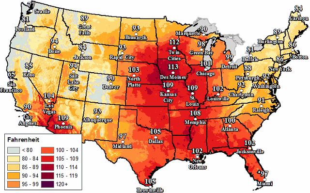 |
| In the picture: Forecasts called for dangerous heat index values over 100 degrees all the way to Minnesota on 07/21/2016. |
|
| |
|
The most dangerous heat of the summer was realized by the 21st/22nd over the middle of the country. Triple digit heat index values were common. Even areas to the north (all the way to Minnesota) could not escape blowtorch conditions. In Arkansas, afternoon heat indices exceeded 110 degrees in places.
On the 22nd at 400 pm CDT, heat indices were between 110 and 115 degrees at Little Rock (Pulaski County), Newport (Jackson County), Searcy (White County), and Stuttgart (Arkansas County). The high temperature for the day was 105 degrees at Little Rock (Pulaski County), which tied a daily record (set in 1943). It was 102 degrees at De Queen (Sevier County), Hot Springs (Garland County), Mount Ida (Montgomery County), and Texarkana (Miller County). The mercury hit 101 degrees at Fort Smith (Sebastian County).
|
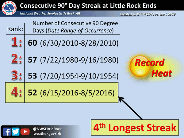 |
| In the picture: A 52-day streak of 90 degree days ended on August 6, 2016 at Little Rock (Pulaski County). The high temperature on the 6th was only 84 degrees. |
|
| |
|
Extreme heat continued in parts of the state to begin August. The mercury hit the century mark four days in a row (the 2nd through the 5th) at Fort Smith (Sebastian County), and three days straight (the 3rd through the 5th) at Little Rock (Pulaski County). On the 6th, a front from the north brought lots of clouds and cooler conditions. High temperatures were only in the 70s and 80s, which snapped a 52-day streak of readings in the 90s at Little Rock (Pulaski County).
|
|
|
| |
|
A week later, a storm system wobbled toward the state from the Gulf Coast, and was surrounded by a lot of moisture. In fact, moisture levels were near historic high levels, which boosted rainfall efficiency. The moisture pooled around a stalled front over the region, and there is your recipe for a deluge.
On the 13th, two to three inches of rain fell in portions of the Ozark and Ouachita Mountains (northern and western sections of the state). Late on the 14th/early on the 15th, there was a narrow band of intense rain and over four inches of liquid from just northwest of Arkadelphia (Clark County) to west Little Rock (Pulaski County), Greers Ferry (Cleburne County), and Pocahontas (Randolph County).
|
| Eighty Four Hour Rainfall Through 800 pm CDT on 08/15/2016 |
| Site |
Rainfall (Inches) |
| Ravenden Springs (Randolph Co) |
7.71 |
| Chenal Valley/West Little Rock (Pulaski Co) |
7.61 |
| Pocahontas (Randolph Co) |
7.20 |
| Nunley (Polk Co) |
6.81 |
| Oden (Montgomery Co) |
6.27 |
| Quitman (Cleburne Co) |
6.26 |
| Greers Ferry (Cleburne Co) |
6.07 |
| Evening Shade (Sharp Co) |
5.97 |
| Lake DeGray (Clark/Hot Spring Co) |
5.95 |
| Guy (Faulkner Co) |
5.37 |
| Batesville (Independence Co) |
5.00 |
|
|
| In the picture: Portions of the Black, Cache and lower White Rivers were above flood stage at several forecast points on 08/19/2016. Widespread agricultural flooding was expected in areas surrounding the rivers. |
|
| |
|
In the days to follow, rivers were on the rise. Initially, flashy (fast up and down) tributaries such as the Spring and Eleven Point Rivers were impacted. Eventually, the Black, Cache, and lower White Rivers were climbing. These rivers were expected to inundate (with water) thousands of acres of agricultural land, especially in Jackson, eastern White, and Woodruff Counties.
|
| Flooding in Southern Louisiana |
|
A State of Emergency was declared following one to more than two feet of rain in southern sections of Louisiana. The situation was dire, with neighborhoods inundated with water and evacuations/numerous rescues taking place. Interstates 10 and 12 were closed near Baton Rouge, LA. There were record crests on several tributaries. The Amite River at Denham Springs, LA topped out 4 to 5 feet higher than previous high marks dating back to the 1920s.
|
|
Long standing August precipitation records (amounts over 10 inches) were snapped at Greers Ferry (Cleburne County), Mount Ida (Montgomery County), and Mountain View (Stone County). Records at these places go back to 1903, 1924, and 1872 respectively!
It was the third wettest August on record in Arkansas. Interestingly, it was not overly wet everywhere. It was actually dry in the northwest, with only 1.09 inches (34 percent of average) of rain at Fayetteville (Washington County).
|
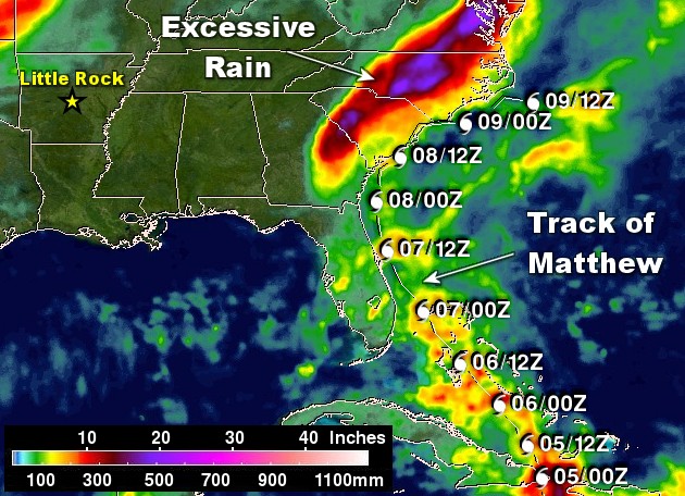 |
| In the picture: Hurricane Matthew headed from the Caribbean Sea to the western Atlantic Ocean in early October, 2016. The system followed the coastline from Florida to the Carolinas, and produced a tremendous amount of rain. The graphic is courtesy of NASA. |
|
| |
|
The tropics were slow to come alive in 2016. El Niño conditions (warmer than normal water along the equator in the Pacific Ocean) kept systems in the Atlantic basin to a minimum. Only four named storms were counted through July. After that, El Niño weakened (water temperatures cooled), and systems ramped up with greater frequency. Through December, there were fifteen named storms, with seven hurricanes (sustained wind at least 74 mph) and three major hurricanes (sustained wind at least 111 mph).
The strongest system was Matthew, which was the first Category 5 storm (sustained wind at least 155 mph) since Felix in 2007. Matthew skirted the coast from Florida to North Carolina in early October.
|
| Hurricane Matthew Impacts |
|
Hurricane Matthew tracked from Florida to the mid-Atlantic Coast from October 7th through the 9th. Wind gusts topped 90 mph at several sites, and over a foot of rain dumped in the Carolinas and Virginia. This caused widespread and destructive flooding. High water forced thousands of people to leave their homes. At least 40 people were killed by the storm in the U.S.
|
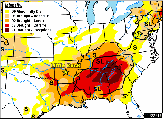 |
| In the picture: Serious drought conditions (D2 to D4) existed in the southesast United States on 11/22/2016). |
|
| |
|
Umbrellas were not needed much in the fall (September through November). A grand total of 6 to 7 inches of rain was tallied in a three month period (statewide average), which was 4 to 5 inches below average. It was also very warm, with temperatures that were 4 to 5 degrees above average. It was the 2nd warmest and 11th driest fall on record. Vegetation was not only stressed due to a short supply of water, it was slow to go dormant due to a lack of cold air. In the end, drought conditions over the southeast United States spread into Arkansas.
|
| Storms in the Southeast/Fire at Gatlinburg |
|
A front came to a halt just to the southeast of Arkansas on November 29th. The front was a focus for numerous thunderstorms, and these became severe. Strong tornadoes (rated EF2/EF3) ripped through northern Alabama and southern Tennessee, and these were deadly. At least 7 fatalities were reported.
Also on the 29th, 2.32 inches of rain dumped on Atlanta, GA. It had not rained (at least 0.01 inch) since October 16th (a 43 day stretch). This was the longest period without measurable rain on record in the city, breaking the previous mark of 39 days in 1884!
Before the rain arrived in the southeast, winds kicked up in Gatlinburg, TN during the evening of the 28th. Wildfires were ongoing due to extremely dry conditions and a continuing drought. Gusts exceeding 60 mph fanned the flames, and fire spread rapidly. Hundreds of buildings were damaged or destroyed. At least 13 people were killed. This was supposedly the worst wildfire disaster in Tennessee in a century.
|
|
|
| In the picture: The WSR-88D (Doppler Weather Radar) showed showers and thunderstorms in southeast Arkansas and a light wintry mix across the northwest at 838 pm CST on 12/17/2016. |
|
| |
|
The year ended with periods of rain and some drought relief in December. During the evening of the 17th, there was one last tornado (rated EF1) in springlike air (temperatures in the 60s/lower 70s) north of Grapevine (Grant County). At the same time, it was sharply colder air in northern Arkansas, with very light patches of wintry precipitation. This was the coldest air of 2016, and it overspread the region during the overnight hours.
By the morning of the 19th, low temperatures were in the single digits and teens. It was 1 degree at Kingston (Madison County). The low was 3 degrees at Fayetteville and Winslow (both in Washington County), and also at Compton (Newton County) and Lead Hill (Boone County). At Dennard (Van Buren County) and Gilbert (Searcy County), it was 5 degrees.
|
|
|