National Weather Service United States Department of Commerce

Storm Impacting the Northwest U.S.; Fire Weather Conditions in Southern California; Severe Weather in the South

A Pacific storm is bringing areas of low elevation rain, moderate to heavy mountain snow, and high winds to the Northwest. Strong Santa Ana winds and very dry conditions are producing elevated to critical fire weather conditions in southern California. Isolated strong to severe thunderstorms are possible through early Wednesday morning across parts of northeast Texas into western Tennessee. Read More >

Today's Forecast Map
Tomorrow's Forecast Map
Day 3 Forecast Map
Storm Prediction Center Recent Activity
Ohio River Basin Significant Flood Outlook
WPC Day 1 Precipitation Forecast
WPC Day 2 Precipitation Forecast
WPC Day 3 Precipitation Forecast
WPC Day 4-5 Precipitation Forecast
WPC Day 6-7 Precipitation Forecast
WPC 7 Day Precipitation Forecast
WPC Day 2 Excessive Rainfall Outlook
WPC Day 3 Excessive Rainfall Outlook
WPC Day 1 Snowfall Greater Than 4" Outlook
WPC Day 2 Snowfall Greater Than 4" Outlook
WPC Day 3 Snowfall Greater Than 4" Outlook
WPC Day 1 Freezing Rain Greater Than 1/4" Outlook
WPC Day 2 Freezing Rain Greater Than 1/4" Outlook
WPC Day 3 Freezing Rain Greater Than 1/4" Outlook
WFAS Observed Fire Danger
WFAS Forecast Fire Danger
SPC Day 1 Fire Outlook
SPC Day 2 Fire Outlook
SPC Day 3-8 Fire Outlook


903
FLUS43 KJKL 312025 AAA
HWOJKL

Hazardous Weather Outlook...UPDATED
National Weather Service Jackson KY
425 PM EDT Mon Mar 31 2025

KYZ044-050>052-058>060-068-069-079-080-083-084-104-106>109-111-112-
114-012030-
Fleming-Montgomery-Bath-Rowan-Estill-Powell-Menifee-Rockcastle-
Jackson-Pulaski-Laurel-Wayne-McCreary-Elliott-Morgan-Johnson-Wolfe-
Magoffin-Lee-Breathitt-Owsley-
425 PM EDT Mon Mar 31 2025

...FLOOD WATCH IN EFFECT FROM WEDNESDAY EVENING THROUGH SUNDAY
MORNING...

This Hazardous Weather Outlook is for a portion of eastern Kentucky.

.DAY ONE...Tonight.

Some scattered frost is possible late tonight.

.DAYS TWO THROUGH SEVEN...Tuesday through Sunday.

Thunderstorm chances return Wednesday evening and persist through
Sunday. Additionally, there is a risk for strong to severe
thunderstorms from Wednesday evening through Thursday night.

We are looking at repeated rounds of heavy rain and thunderstorms to
impact parts of the Lower and Middle Ohio River Valley region
from Wednesday evening into the upcoming weekend. This will mean a
heightened risk for flooding through the watch area.

.SPOTTER INFORMATION STATEMENT...

Spotter activation is not expected at this time.

$$

KYZ085>088-110-113-115>120-012030-
Whitley-Knox-Bell-Harlan-Floyd-Knott-Perry-Clay-Leslie-Letcher-
Martin-Pike-
425 PM EDT Mon Mar 31 2025

This Hazardous Weather Outlook is for a portion of eastern Kentucky.

.DAY ONE...This afternoon through tonight.

Thunderstorms are possible into the first part of the evening.

.DAYS TWO THROUGH SEVEN...Tuesday through Sunday.

Thunderstorm chances return Wednesday night and persist through
Sunday. Additionally, there is a risk for strong to severe
thunderstorms from Wednesday evening through Thursday night.

Repeated rounds of showers and thunderstorms could affect southeast
parts of Kentucky from Wednesday night into the upcoming weekend with
heavy rainfall and a potential for flooding.

.SPOTTER INFORMATION STATEMENT...

Spotter activation is not expected at this time.

$$

GREIF


Weather Story
Today's Forecast Map
Tomorrow's Forecast Map
Day 3 Forecast Map


Severe Thunderstorms

Current Watches
Current SPC Convective Watches
Storm Trend Discussions
Today's Storm Reports
Yesterday's Storm Reports


SPC Day 1 Thunderstorm Outlook SPC Day 1 Tornado Outlook SPC Day 1 Severe Wind Outlook SPC Day 1 Severe Hail Outlook
Day 1 Severe Weather Outlook from the SPC
Day 1 Tornado Outlook from the SPC
Day 1 Severe Wind Outlook from the SPC
Day 1 Severe Hail from the SPC
SPC Day 1 Thunderstorm Outlook Narrative


SPC Day 2 Thunderstorm Outlook SPC Day 3 Thunderstorm Outlook SPC Day 4-8 Thunderstorm Outlook
Day 2 Severe Weather Outlook from the SPC Day 3 Severe Weather Outlook from the SPC Day 4-8 Severe Weather Outlook from the SPC
SPC Day 2 Outlook Narrative SPC Day 3 Outlook Narrative SPC Day 4-8 Outlook Narrative


Rainfall/Flooding

Day 1 Excessive Rainfall Outlook Day 2 Excessive Rainfall Outlook Day 3 Excessive Rainfall Outlook


Day 1 Precipitation Day 2 Precipitation Day 3 Precipitation
     
Day 4-5 Precipitation Day 6-7 Precipitation 7-Day Total Precipitation


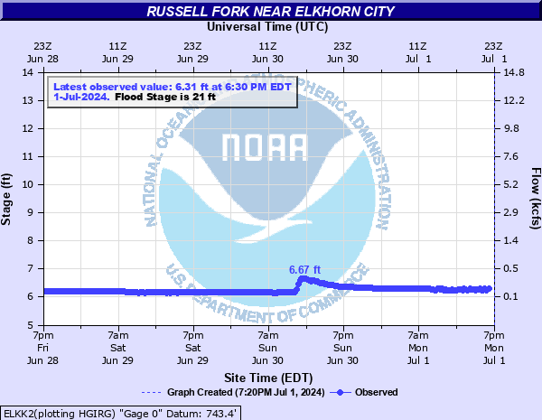
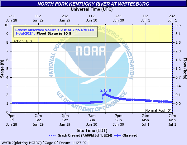
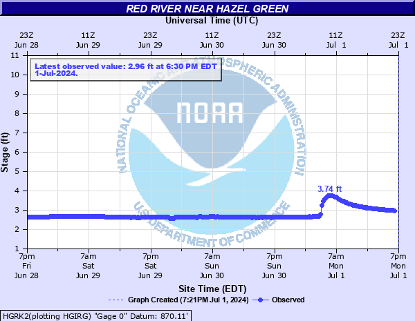
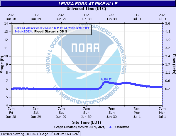
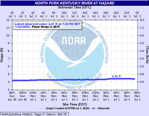
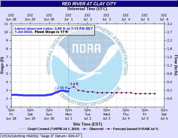
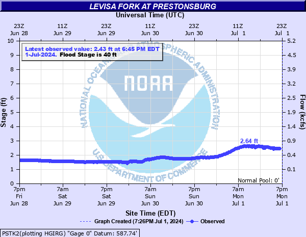
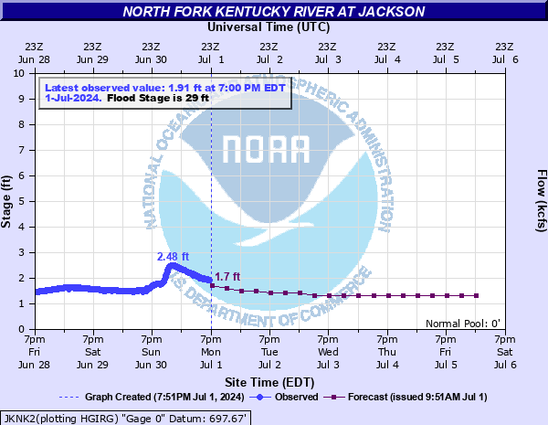
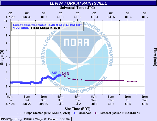
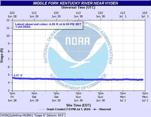
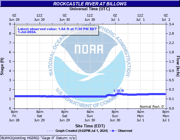
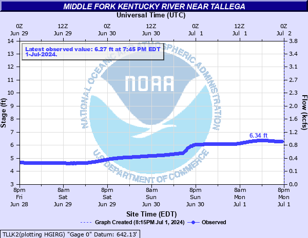
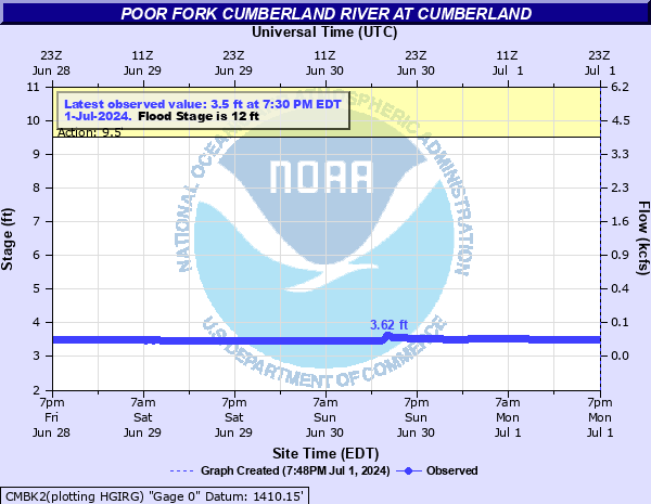
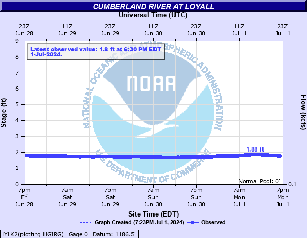
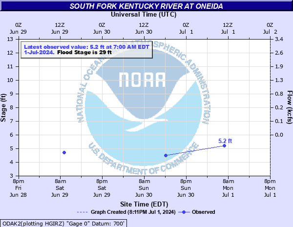
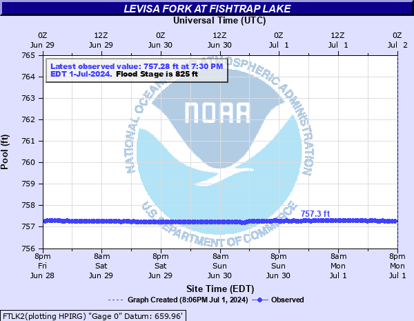
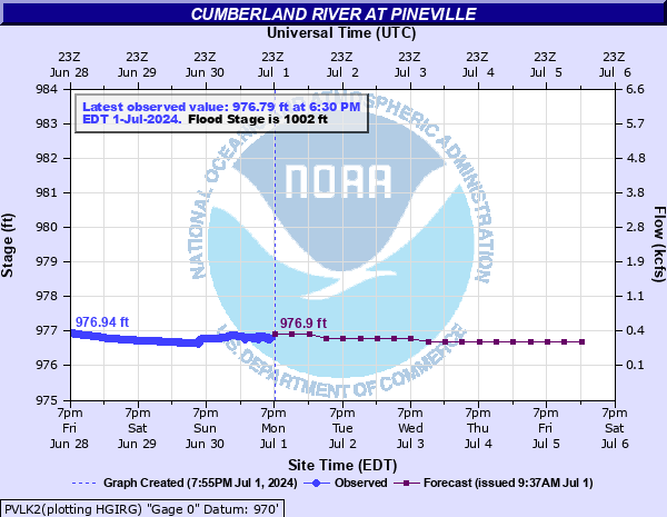
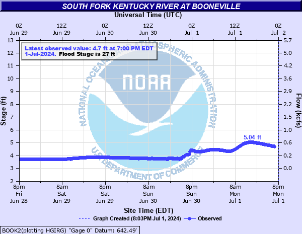
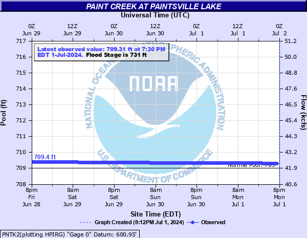
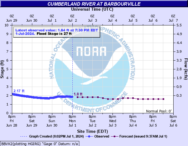
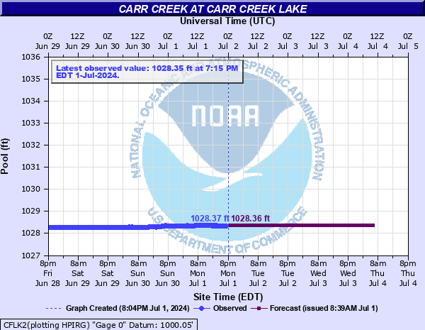
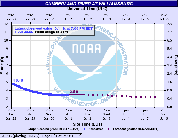
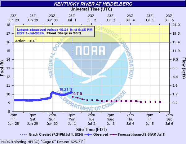
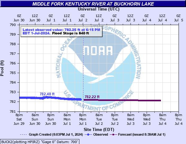
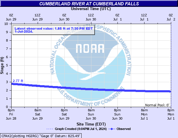
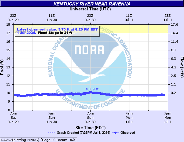
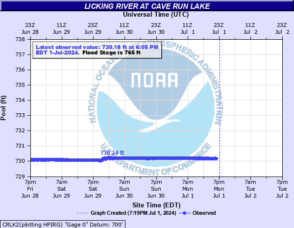
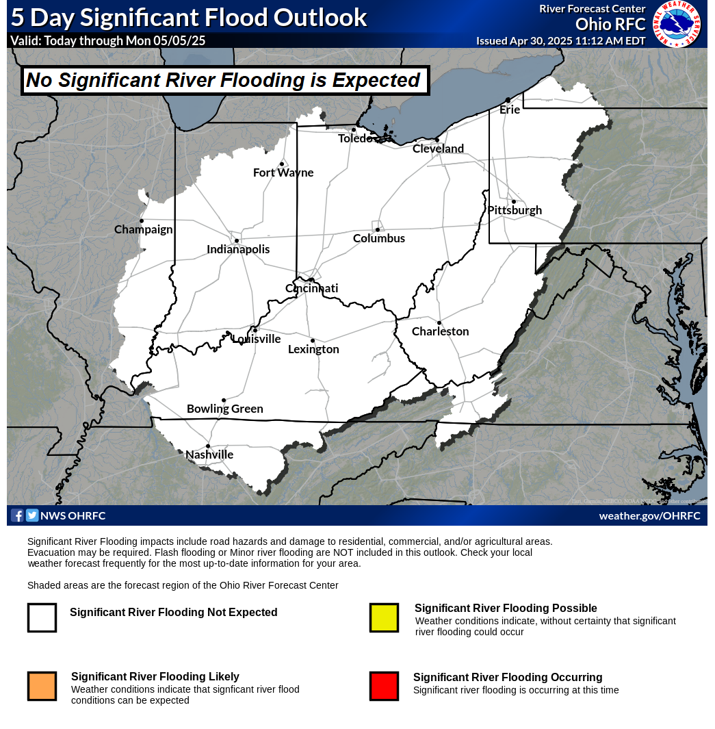
Rivers/Lakes Quick Glance (click icons to enlarge or click here for more info and additonal locations) Ohio River Basin Flood Outlook
Big Sandy River Kentucky River Red River
NA Russel Fk at Elkorn City NA North Fk at Whitesburg NA Hazel Green
NA Levisa Fk at Pikeville NA North Fk at Hazard NA Clay City
NA Levisa Fk at Prestonsburg NA North Fk at Jackson  
NA Levisa Fk at Paintsville     Rockcastle River
    NA Middle Fk near Hyden NA Billows
Cumberland River NA Middle Fk near Tallega  
NA Cumberland     Area Lake Levels
NA Loyall NA South Fk at Oneida NA Fishtrap Lake
NA Pineville NA South Fk at Booneville NA Paintsville Lake
NA Barbourville     NA Carr Creek Lake
NA Williamsburg NA Main Stem at Heidelberg NA Buckhorn Lake
NA Cumberland Falls NA Main Stem near Ravenna NA Cave Run Lake
Ohio River Basin Flood Outlook


Winter Weather

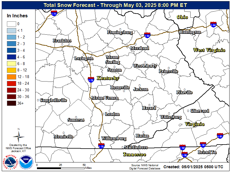
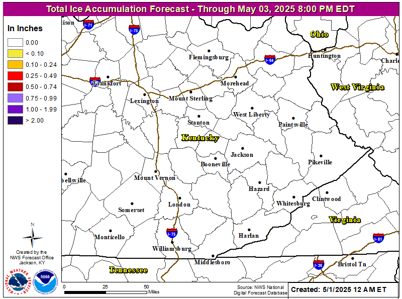
Local Office Snow & Ice Forecasts


Day 1 Snowfall Greater Than 4" Day 2 Snowfall Greater Than 4" Day 3 Snowfall Greater Than 4"
     
Day 1 Freezing Rain Greater than 1/4" Day 2 Freezing Rain Greater than 1/4" Day 3 Freezing Rain Greater than 1/4"


Fire Weather & Drought

WFAS Observed Fire Danger Rating
WFAS Forecast Fire Danger Rating
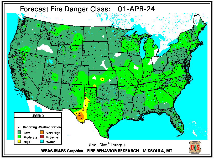
 

SPC Fire Weather Day 1 Outlook SPC Fire Weather Day 2 Outlook SPC Fire Weather Day 3-8 Outlook
SPC Day 1 Fire Weather Outlook
SPC Day 2 Fire Weather Outlook
SPC Day 3 Fire Weather Outlook


Drought Monitor Seasonal Drought Outlook NICC Significant Fire Potential Outlook


Tropical Weather