Tropical Depression Two is expected to gradually strengthen and could bring tropical storm conditions to the Florida Panhandle beginning late Monday. Areas of flash flooding will be possible through Thursday along the eastern and central Gulf Coast. Severe thunderstorms will develop and move along a cold front crossing the Upper Midwest Monday, and through the Ohio Valley/Mid-Atlantic on Tuesday. Read More >
...NWS Damage Survey for the May 6, 2022 Tornado Event...
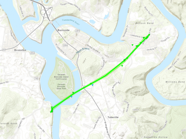
.Pulaski County Tornado...
Rating: EF1
Estimated Peak Wind: 110 mph
Path Length /statute/: 3.186 miles
Path Width /maximum/: 100.0 yards
Fatalities: 0
Injuries: 2
Start Date: 05/06/2022
Start Time: 01:49 PM EDT
Start Location: 1 SSW General Burnside State Park /
Pulaski County / KY
Start Lat/Lon: 36.964 / -84.6075
End Date: 05/06/2022
End Time: 01:57 PM EDT
End Location: 2 ENE Burnside / Pulaski County / KY
End Lat/Lon: 36.9923 / -84.5627
Survey Summary:
The NWS Survey Team, in conjunction with the Bronston, Burnside
and Haynes Knob Fire Departments, confirmed that a tornado touched
down on Hardwick Road in the Bronston Community. Initially it
resulted in numerous tree damage upon touchdown, then impacted
multiple structures as it moved NNE along Hardwick Road, including
the rolling of two mobile homes and injuring two residents. The
tornado then continued across the Cumberland River, clipping the
southern portion of General Burnside State Park, mainly near the
boat ramp parking lot, resulting in further tree damage. From here
it moved on across the river and made its way toward the Lake
Cumberland Speedway, which sustained multiple points of damage.
The tornado then tracked northeast into the Antioch community,
resulting in numerous instances of structural and tree damage. The
tornado finally lifted on Antioch Church Road near Antioch Bend.
Maximum sustained winds were 110 mph with a path length of just
over 3 miles, and a path width of 100 yards.
Special thanks to the Fire Chiefs of the Bronston, Burnside, and
Haynes Knob Fire Departments.
EF Scale: The Enhanced Fujita Scale classifies tornadoes into the
following categories:
EF0...Weak......65 to 85 mph
EF1...Weak......86 to 110 mph
EF2...Strong....111 to 135 mph
EF3...Strong....136 to 165 mph
EF4...Violent...166 to 200 mph
EF5...Violent...>200 mph
NOTE:
The information in this statement is preliminary and subject to
change pending final review of the event and publication in NWS
Storm Data.