
Tropical Depression Two is expected to gradually strengthen and could bring tropical storm conditions to the Florida Panhandle beginning late Monday. Areas of flash flooding will be possible through Thursday along the eastern and central Gulf Coast. Severe thunderstorms will develop and move along a cold front crossing the Upper Midwest Monday, and through the Ohio Valley/Mid-Atlantic on Tuesday. Read More >
Overview
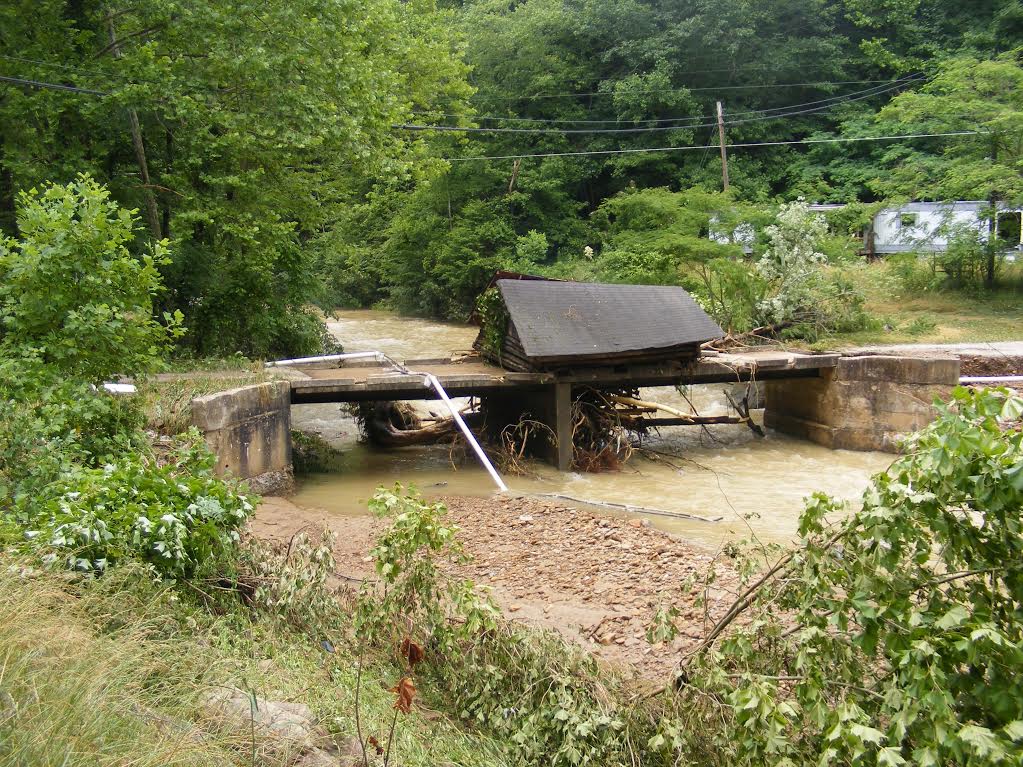
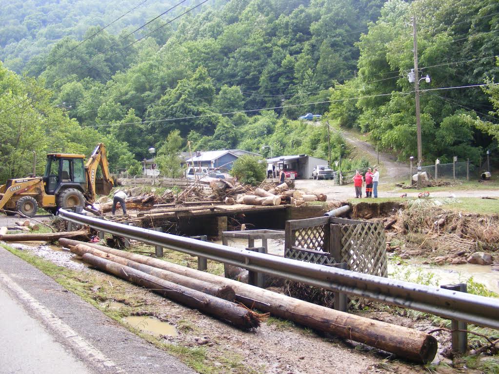
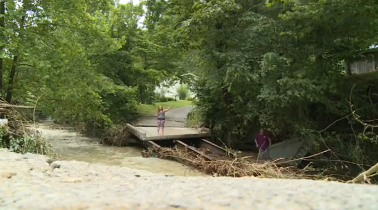
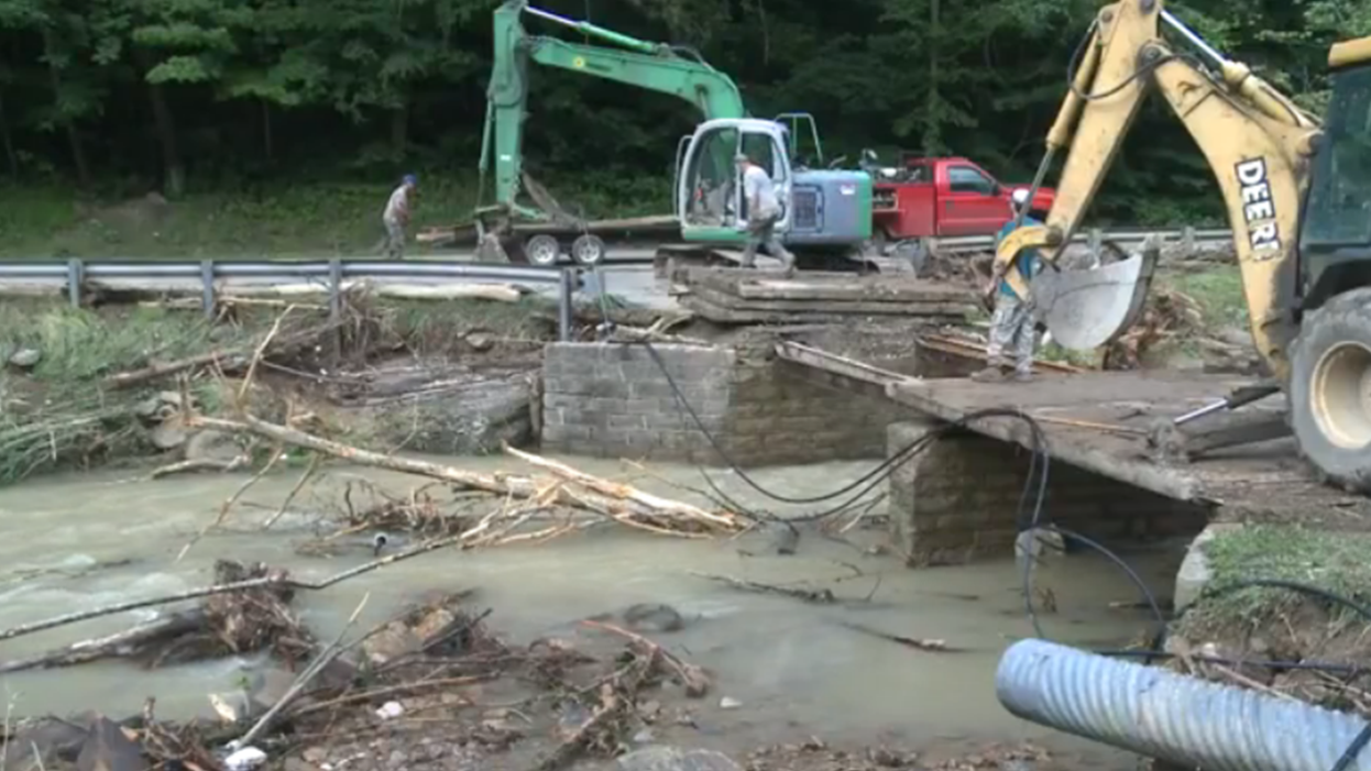
A line of strong to severe thunderstorms developed during the early afternoon on Tuesday June 21, 2016 along and south of the Ohio River, moving into eastern Kentucky during the mid afternoon hours. Sporadic wind damage occurred across Estill County as well as Morgan and Bell Counties. Much more significant impacts developed during the evening hours as a training line of storms set up across eastern Bell, southern Leslie, and Harlan Counties. This led to widespread flash flooding, especially across Harlan County, while several other homes and roads were also impacted across Leslie and Bell Counties.
Flooding
Harlan County, KY was hardest hit, with 75 to 100 homes affected. The most significant damage occurred in Bledsoe where 3 to 4 feet of water was reported in some homes. American Red Cross teams were mobilized to Harlan County, providing food and water to residents.
 |
 |
| Flood damage in southern Leslie County near the Harlan County line. Courtesy James Slusher. | |
 |
 |
| Flood damage in Harlan County. Courtesy WYMT. | Flood damage in Leslie County. Courtesy WYMT. |
Radar
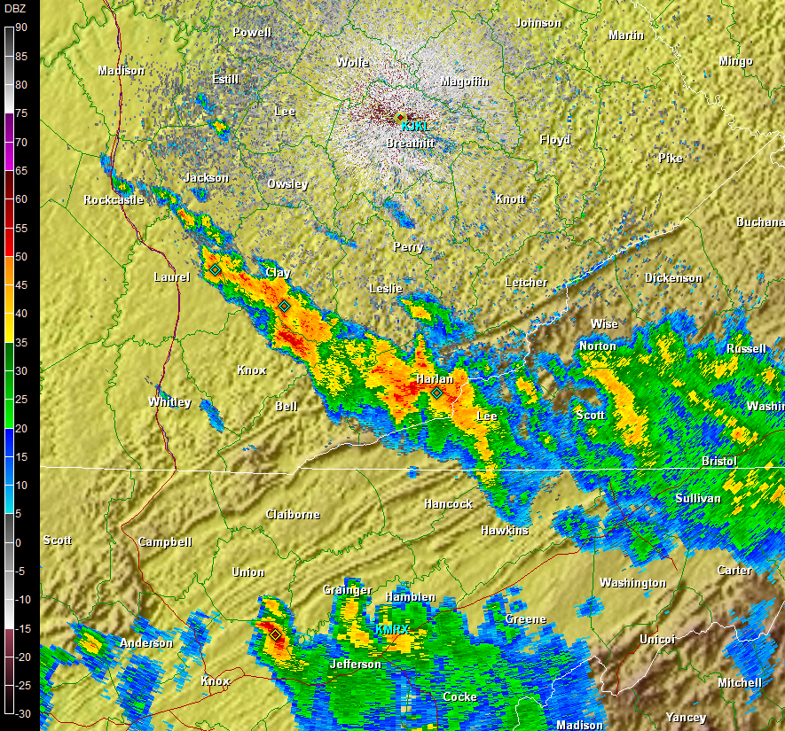 |
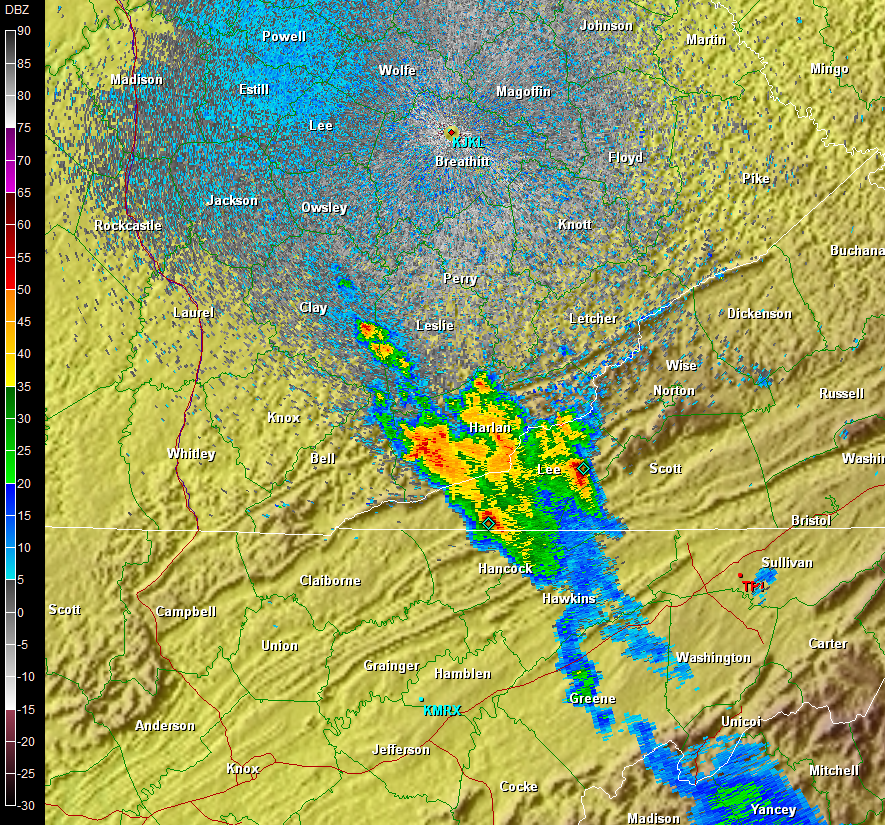 |
| Radar imagery from 6/21/2016 at 8:38 pm EDT. | Radar imagery from 6/21/2016 at 11:24 pm EDT. Storms continue to train over southern Leslie, eastern Bell, and Harlan Counties nearly 3 hours later. |
Rainfall Amounts
Radar estimates and rain gauges indicated 3 to 6 inches of rain fell Tuesday night across Harlan County. A Coop Observer 3 miles north of Harlan measured 6.02 inches of rain.
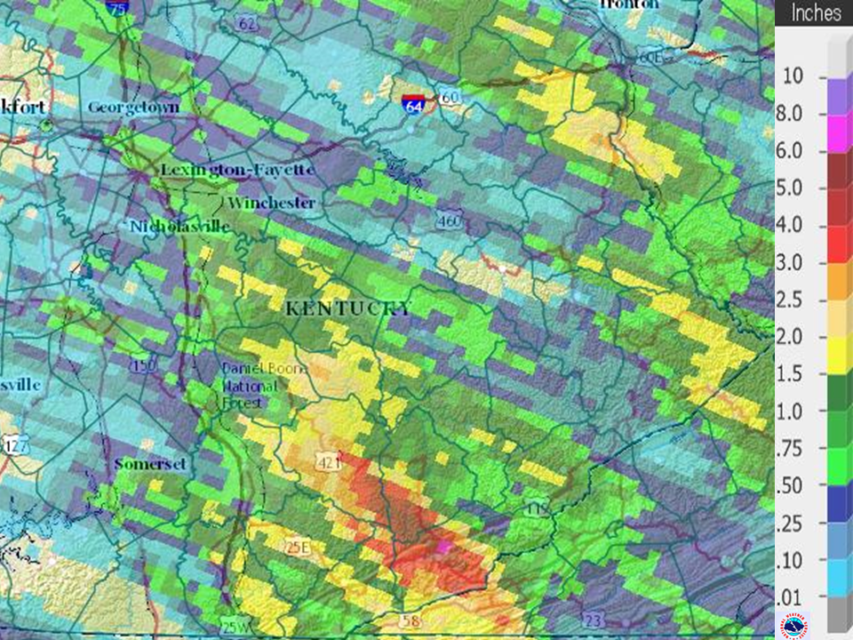 |
| Radar estimated rainfall amounts from 6/21/2016. |
SXUS53 KJKL 221500
OSOJKL
COUNTY RAINFALL SUMMARY
NATIONAL WEATHER SERVICE JACKSON KY
1100 AM EDT WED JUN 22 2016

...County Based Rainfall Summary for the 24 Hour Period Ending around
7 am EST June 22...

This is an automatically generated product providing a summary of
all rain gauge data available in each county in the NWS Jackson, KY
forecast and warning area. No quality control has been performed on
this data.

                                                24Hr
Id      Station Name               Lat/Lon      Pcpn

...Bath County Gauges...
PRSTKY Owingsville 4S           38.09N/83.76W   0.46
OLSK2  Olympia Springs IFLOWS   38.06N/83.64W   0.48
PLOK2  Peeled Oak IFLOWS        38.06N/83.80W   0.75
RNVK2  Reynoldsville IFLOWS     38.19N/83.82W   0.67

...Bell County Gauges...
MBOK2  Middlesboro 4W           36.61N/83.79W     MM
1A6    Middlesboro AWOS         36.62N/83.74W   0.40
YELK2  Yellow Creek RAWS        36.60N/83.70W   0.54
MDLK2  Meldrum Stream Gauge     36.67N/83.69W   0.63
PVLK2  Pineville River Gauge    36.76N/83.69W   1.99
ARJK2  Arjay IFLOWS             36.81N/83.65W   1.18
MDBK2  Middlesboro IFLOWS       36.61N/83.71W   0.00
MNMK2  Mingo Mountain IFLOWS    36.74N/83.69W   1.93
YLCK2  Yellow Creek IFLOWS      36.67N/83.69W   0.47

...Breathitt County Gauges...
OSDK2  Quicksand                37.53N/83.37W   0.19
KYBE01 Talbert 1.9ESE           37.41N/83.43W   1.42
QKSDKY Jackson 3SE              37.54N/83.34W   0.19
JKL    Jackson ASOS             37.60N/83.32W   0.43
JCAK2  Jackson Apt RAWS         37.59N/83.32W   0.40
JKNK2  Jackson River Gauge      37.55N/83.39W   0.18
BTKK2  Frozen IFLOWS            37.59N/83.34W     MM
RBNK2  Robinson Forest IFLOWS   37.47N/83.16W     MM
SGLK2  Sugar Lump Branch IFLOWS 37.57N/83.19W   0.94
BLHK2  Lost Creek IFLOWS        37.48N/83.32W   0.31
TWHK2  Town Hill IFLOWS         37.55N/83.39W   0.28

...Clay County Gauges...
ODAK2  Oneida                   37.27N/83.65W   0.00
CHTK2  Peabody                  37.14N/83.58W   1.91
MCHK2  Manchester               37.15N/83.76W   2.49
BCRK2  Big Creek                37.16N/83.57W   0.00
MHRK2  Manchester IFLOWS        37.16N/83.76W   2.44

...Elliott County Gauges...
GIMK2  Gimlet 9N                38.22N/83.13W     T
SDHK2  Sandy Hook               38.10N/83.12W   0.20
KYEL01 Olive Hill 9.0SSE        38.19N/83.08W     MM
KYEL03 Isonville 0.4ESE         38.06N/83.05W     MM
KYEL04 Sandy Hook 3.2NNE        38.13N/83.09W     MM
SHKK2  Sandy Hook IFLOWS        38.10N/83.12W     MM
ALTK2  Ault IFLOWS              38.20N/83.21W     MM
DRTK2  Doctor Tower IFLOWS      38.08N/83.21W   0.00
RKBK2  Rocky Branch IFLOWS      38.09N/83.04W     MM

...Estill County Gauges...
CSYK2  Cressy                   37.83N/84.04W   1.44
KYES01 Irvine 8.7WSW            37.64N/84.11W     MM
KYES03 Irvine 9.8SSW            37.58N/84.06W     MM
CHSK2  Chestnut Stand IFLOWS    37.73N/83.94W   2.41

...Fleming County Gauges...
FLEK2  Flemingsburg 2N          38.45N/83.73W   0.09
HILK2  Hillsboro                38.32N/83.66W     MM
SRKK2  Sharkey                  38.25N/83.57W   0.08
BDHK2  Bald Hill IFLOWS         38.35N/83.71W   0.00
BHBK2  Beechburg IFLOWS         38.45N/83.65W   0.00
FRVK2  Fairview IFLOWS          38.44N/83.89W     MM
FMBK2  Flemingsburg IFLOWS      38.43N/83.75W   0.00
MSHK2  Muses Mills IFLOWS       38.37N/83.53W   0.00

...Floyd County Gauges...
PELK2  Prestonsbug 3WSW         37.64N/82.82W     MM
KYFD05 Banner 3.1S              37.55N/82.70W     MM
DWYK2  Dewey Lake               37.74N/82.73W   0.40
PSTK2  Prestonsburg             37.67N/82.78W   0.02
PRCK2  Price                    37.40N/82.72W     MM
SRSK2  Hwy 7 near Price IFLOWS  37.38N/82.78W   0.12
GRTK2  Garrett IFLOWS           37.48N/82.83W   0.12
MCDK2  McDowell IFLOWS          37.46N/82.74W   0.00
BVCK2  Martin IFLOWS            37.57N/82.75W   0.20
DVDK2  David IFLOWS             37.61N/82.87W   0.12
LBRK2  Left Beaver IFLOWS       37.51N/82.71W   0.00
MELK2  Melvin IFLOWS            37.35N/82.66W   0.20
MDKK2  Middle Creek IFLOWS      37.67N/82.92W   0.00
MCRK2  Mud Creek IFLOWS         37.48N/82.66W     MM
MDYK2  Muddy IFLOWS             37.43N/82.81W   0.24
RBRK2  Right Beaver IFLOWS      37.53N/82.79W   0.32
STVK2  Stanville IFLOWS         37.56N/82.64W   0.00

...Harlan County Gauges...
BXTK2  Baxter                   36.86N/83.33W     MM
HLNK2  Harlan                   36.82N/83.32W     MM
HEGK2  Harlan 1S                36.83N/83.33W   3.67
HROK2  Harlan 3N                36.88N/83.31W   6.02
BMTNKY Harlan 24E               36.92N/82.91W   0.84
CMBK2  Cumberland               36.97N/82.99W   0.38
LYLK2  Lloyal                   36.85N/83.35W   3.69
NCFK2  New Clover Fork          36.85N/83.33W   2.49
MFLK2  Martins Fork Lake        36.75N/83.25W   3.42
CCLK2  Cranks Creek Lake        36.73N/83.23W   3.90
CLSK2  Clover Street IFLOWS     36.85N/83.32W   1.78
BGBK2  Big Black IFLOWS         36.92N/82.90W   0.35
EVRK2  Evarts IFLOWS            36.86N/83.20W   3.84
CBRK2  Cumberland IFLOWS        36.97N/82.99W   2.68
EJFK2  E Jones Farm IFLOWS      36.81N/83.41W   0.56
MYHK2  Grays Knob IFLOWS        36.79N/83.29W   1.34
MFIK2  Martins Fork Lake IFLOWS 36.73N/83.26W   2.60
PTYK2  Putney IFLOWS            36.91N/83.20W   1.55

...Jackson County Gauges...
CAVK2  Clover Bottom            37.49N/84.17W   0.88
KYJC01 McKee 9.4NW              37.52N/84.11W   1.31
OLINKY McKee 5S                 37.36N/83.97W   0.47
GRHK2  Gray Hawk                37.40N/83.95W   1.15
MKEK2  McKee IFLOWS             37.42N/83.97W   1.66
PDLK2  Pond Lick IFLOWS         37.33N/83.99W   0.20
SNGK2  Sand Gap IFLOWS          37.48N/84.08W   0.00

...Johnson County Gauges...
PNVK2  Paintsville 1E           37.82N/82.78W   0.76
KYJH04 Staffordsville 3NNW      37.86N/82.86W     MM
BTCKKY Paintsville 4W           37.83N/82.88W   0.76
PTVK2  Paintsville              37.82N/82.79W   0.76
PNTK2  Paintsville Lake         37.84N/82.87W   0.00
FGPK2  Flatgap IFLOWS           37.95N/82.88W   0.00
LNDK2  Leander IFLOWS           37.75N/82.87W     MM
LYBK2  Lindy Branch IFLOWS      37.88N/82.78W   0.04
PTWK2  Paintsville Radio Twr IF 37.82N/82.83W     MM
PTDK2  Staffordsville IFLOWS    37.84N/82.87W   0.24
OLGK2  Thunder Ridge IFLOWS     37.74N/82.75W   0.00

...Knott County Gauges...
ALCK2  Pippa Passes             37.33N/82.88W     MM
CFLK2  Carr Creek Lake Coop     37.23N/83.03W   0.88
KYKT01 Leburn 3.8 N             37.40N/82.96W     MM
VESTKY Hindman 5N               37.41N/82.99W   0.10
CFLK2  Carr Creek Lake Dam      37.23N/83.03W   0.95
BDBK2  Hindman IFLOWS           37.33N/82.98W   0.28
KNKK2  Pippa Passes IFLOWS      37.34N/82.88W   0.16

...Knox County Gauges...
BBVK2  Barbourville Water Plant 36.86N/83.89W   2.35
BBVK2  Barbourville CoCoRaHS    36.87N/83.89W   1.60
BMBLKY Barbourville 3E          36.87N/83.83W   2.51
BBVK2  Barbourville River Gauge 36.86N/83.89W   1.79
ARTK2  Artemus IFLOWS           36.83N/83.83W   1.70
CLFK2  Collins Fork IFLOWS      36.94N/83.84W   0.91
HCBK2  Dewitt IFLOWS            36.88N/83.74W   1.49
HTBK2  Helton Branch IFLOWS     36.88N/83.94W   1.77
KXKK2  Johnson Hollow IFLOWS    36.93N/83.94W   2.39
PGFK2  Pidgeon Fork IFLOWS      36.92N/83.65W   0.75
STNK2  Stoney Fork IFLOWS       36.77N/83.92W   0.00

...Laurel County Gauges...
LDNK2  London                   37.13N/84.10W     MM
BUNK2  Bunch                    37.10N/84.21W   0.14
LOZ    London Corbin Apt        37.08N/84.07W   0.87
BLWK2  Billows                  37.17N/84.30W   0.02
CBNK2  Corbin Dam               36.97N/84.12W   2.15
BUSK2  Hale IFLOWS              37.09N/83.87W   1.29
PKTK2  Keavy Fire Dept IFLOWS   37.06N/84.10W   0.48
EBSK2  Laurel Co. Fire Dept IFL 37.19N/84.12W   1.02
NLRK2  Money Road IFLOWS        37.11N/83.98W   1.46

...Lee County Gauges...
BCAK2  Beattyville 4N           37.63N/83.72W   1.06
HLDK2  Heidelberg               37.55N/83.77W   1.35
TLLK2  Tallega                  37.55N/83.60W   1.11
BTTK2  Beattyville IFLOWS       37.56N/83.69W   2.05
DLVK2  Delvinta IFLOWS          37.50N/83.81W   2.73
LEKK2  Bear Track IFLOWS        37.63N/83.77W     MM
LCOK2  Leeco IFLOWS             37.71N/83.70W   0.47

...Leslie County Gauges...
SMIK2  Smilax                   37.11N/83.28W     MM
HYDK2  Hyden                    37.14N/83.37W   1.10
LSKK2  Asher-Beech Fork IFLOWS  37.00N/83.42W   0.00
CTSK2  Cutshin IFLOWS           37.11N/83.25W     MM
LCDK2  Lucinda IFLOWS           37.14N/83.48W   2.14
GRCK2  Rockhouse Creek IFLOWS   36.99N/83.24W   0.32
WBRK2  Wilder Branch IFLOWS     37.27N/83.40W   1.46

...Letcher County Gauges...
WHTK2  Whitesburg Coop          37.12N/82.82W     MM
WHBK2  Whitesburg 2SE           37.10N/82.80W   1.27
SKLK2  Skyline                  37.07N/82.97W   0.65
KDCK2  Kingdom Come S.P.        37.00N/82.98W     MM
WTBGKY Whitesburg 2NW           37.13N/82.84W   1.07
WHTK2  Whitesburg River Gauge   37.12N/82.82W   0.99
LCKK2  Bright                   37.08N/82.81W   0.00
WBAK2  Whitesburg EOC IFLOWS    37.13N/82.78W   0.67
KDCK2  Kingdom Come S.P. IFLOWS 37.00N/82.98W   0.87

...Magoffin County Gauges...
KYMA06 Salyersville 6.1NW       37.82N/83.13W     MM
BBRK2  Back Branch IFLOWS       37.71N/83.13W   0.00
FLNK2  Falcon (Cassidy) IFLOWS  37.78N/83.01W     MM
FTGK2  Flat Fork IFLOWS         37.84N/83.04W   0.00
FVEK2  Fredville IFLOWS         37.61N/82.98W     MM
EKBK2  Salyersville IFLOWS      37.76N/83.06W     MM

...Martin County Gauges...
INEK2  Inez 2E                  37.87N/82.52W   0.26
BSAK2  Big Sandy Apt            37.75N/82.63W   1.18
BSYK2  Big Sandy Apt IFLOWS     37.75N/82.64W   1.50
INZK2  Inez IFLOWS              37.87N/82.54W   0.36
OPPK2  Oppy IFLOWS              37.75N/82.33W     MM
TOMK2  Tomahawk IFLOWS          37.87N/82.60W     MM

...McCreary County Gauges...
FLRKKY Whitley City 3N          36.77N/84.48W   0.00
STRK2  Stearns                  36.67N/84.48W   0.00
EAGK2  Eagle IFLOWS             36.86N/84.39W   0.00
MVWK2  Mountain View IFLOWS     36.73N/84.57W   0.00
OSBK2  Osborne Creek IFLOWS     36.64N/84.34W   0.00
WCYK2  Whitley City IFLOWS      36.73N/84.47W   0.00

...Menifee County Gauges...
WELK2  Wellington               37.95N/83.48W   0.30
FGNK2  Fagan IFLOWS             37.91N/83.69W     MM
STQK2  Stone Quarry IFLOWS      37.99N/83.62W   0.08

...Montgomery County Gauges...
MTSK2  Mount Sterling 5N        38.06N/83.93W   0.17
KYMM03 Mount Sterling 2.4W      38.07N/83.99W   0.31
CMGK2  Camargo IFLOWS           37.99N/83.89W     MM
JDYK2  Judy IFLOWS              38.13N/83.96W   0.08
LLBK2  Lulbegrud IFLOWS         38.01N/83.95W   0.00
MSTK2  Mt. Sterling IFLOWS      38.06N/83.96W   0.39
PRTK2  Pruitt Road IFLOWS       38.03N/84.01W   0.00
STWK2  Salt Well IFLOWS         38.09N/83.91W   0.16
SCRK2  Science Ridge IFLOWS     37.98N/83.82W     MM
SHCK2  Shedd Creek IFLOWS       38.05N/83.89W   0.76

...Morgan County Gauges...
EZLK2  Ezel                     37.83N/83.47W     MM
WLBTKY West Liberty 2SW         37.90N/83.27W   0.04
CHCK2  Cannel City IFLOWS       37.79N/83.28W   0.00
MMAK2  East Valley IFLOWS       37.95N/83.16W   0.00
GRKK2  Grassy Creek IFLOWS      37.85N/83.35W   0.00
MYTK2  Maytown IFLOWS           37.85N/83.47W   0.00
WLPK2  Wolfpen IFLOWS           38.07N/83.29W   0.00

...Owsley County Gauges...
ICYK2  Island City              37.36N/83.77W   2.40
BNVLKY Booneville 2S            37.45N/83.69W   1.63
BOOK2  Booneville               37.48N/83.68W   1.66
BONK2  Cow Creek IFLOWS         37.43N/83.61W   1.03
OWKK2  Indian Creek IFLOWS      37.38N/83.58W   1.82
BFLK2  Mistletoe IFLOWS         37.31N/83.59W     MM
LTSK2  Sturgeon IFLOWS          37.45N/83.75W   0.90

...Perry County Gauges...
BUCK2  Buckhorn Lake Coop       37.33N/83.47W   1.24
HAZK2  Hazard Water Plant       37.25N/83.18W   1.92
HZDK2  Hazard State Police      37.25N/83.18W     MM
KYPR04 Viper 0.5N               37.19N/83.15W   0.63
KYPR05 Hazard 1.7NW             37.27N/83.21W   1.52
BUCK2  Buckhorn Lake Dam        37.33N/83.47W   1.34
HAZK2  Hazard River Gauge       37.25N/83.18W   1.73
BFFK2  Buffalo IFLOWS           37.19N/83.19W   0.91
HZAK2  Hazard IFLOWS            37.25N/83.17W   0.52
RKHK2  Rockhouse IFLOWS         37.39N/83.27W   1.19

...Pike County Gauges...
FEDK2  Fedscreek                37.40N/82.23W   1.76
DORTKY Pikeville 13S            37.28N/82.52W   0.00
PKYK2  Pikeville                37.46N/82.53W   0.36
MTGK2  Meta                     37.57N/82.47W   0.66
FTLK2  Fishtrap Lake            37.43N/82.42W   0.49
VRGK2  Virgie                   37.33N/82.58W   0.10
ELKK2  Elkhorn City             37.30N/82.34W   0.40
HTFK2  Hatfield IFLOWS          37.66N/82.38W   0.60
PCRK2  Pond Creek IFLOWS        37.58N/82.27W   1.93
MYRK2  Myra IFLOWS              37.30N/82.61W   0.12
PLPK2  Phelps IFLOWS            37.51N/82.15W   2.72
VIRK2  Virgie IFLOWS            37.34N/82.59W   0.24
BEFK2  Beefhide IFLOWS          37.25N/82.62W   0.16
DKBK2  Dicks Knob IFLOWS        37.50N/82.23W   0.12
ERHK2  East Ridge School IFLOWS 37.36N/82.31W   2.44
FTMK2  Flatwoods IFLOWS         37.28N/82.52W   0.16
GULK2  Gulnare IFLOWS           37.63N/82.54W   0.28
JHPK2  Johns Peak IFLOWS        37.47N/82.54W   0.00
LGFK2  Longfork IFLOWS          37.30N/82.67W   0.20
MBNK2  Marrowbone IFLOWS        37.35N/82.42W   0.08
RACK2  Raccoon IFLOWS           37.49N/82.44W   1.10
SIDK2  Sidney IFLOWS            37.62N/82.35W   2.37

...Powell County Gauges...
CYCK2  Clay City 1WNW           37.86N/83.93W   0.72
STAK2  Stanton 2W               37.86N/83.90W   0.46
CYCK2  Clay City River Gauge    37.86N/83.93W   0.75
MRMK2  Clay City IFLOWS         37.85N/83.92W   0.28
FUNK2  Furnace IFLOWS           37.76N/83.84W   2.09
HHRK2  Middlefork Fire IFLOWS   37.83N/83.74W   0.35
MCLK2  Natural Bridge IFLOWS    37.77N/83.67W   0.28
CNCK2  Stanton Fire IFLOWS      37.85N/83.86W   0.36

...Pulaski County Gauges...
SSTK2  Somerset 2N Coop         37.12N/84.62W   0.29
COLK2  Colo                     37.06N/84.49W   0.38
KYPL04 Somerset 2.7WNW          37.10N/84.65W     MM
SSTK2  Somerset Stream Gauge    37.12N/84.62W   0.25
SOMK2  Somerset Apt RAWS        37.06N/84.61W   0.19
EUBK2  Eubanks IFLOWS           37.28N/84.66W   0.00
MVIK2  Mt. Victory IFLOWS       37.00N/84.45W   0.12
PUNK2  Punkin Center IFLOWS     37.24N/84.43W   0.00
SCIK2  Science Hill IFLOWS      37.18N/84.63W   0.08

...Rockcastle County Gauges...
MTVK2  Mount Vernon             37.35N/84.33W   0.21
KYRC02 Brodhead 7.3SSW          37.30N/84.46W   0.06
BHDK2  Brodhead School IFLOWS   37.40N/84.42W   0.39
PHCK2  Climax Fire IFLOWS       37.46N/84.23W   0.51
LIVK2  Livingston IFLOWS        37.30N/84.22W   0.70
BNEK2  Roundstone School IFLOWS 37.44N/84.32W   0.00

...Rowan County Gauges...
MRDK2  Morehead                 38.18N/83.47W   0.00
CRLK2  Cave Run Lake Coop       38.12N/83.53W   0.07
KYRW03 Morehead 6.4NE           38.24N/83.34W     T
MRHDKY Morehead 4NE             38.22N/83.48W   0.03
TRMK2  Triangle Mountain        38.17N/83.41W   0.02
FRMK2  Cave Run Farmers         38.14N/83.56W   0.05
CRLK2  Cave Run Lake Dam        38.12N/83.53W   0.09
BKBK2  Buckner Branch IFLOWS    38.35N/83.40W   0.00
TRTK2  Triangle Tower IFLOWS    38.18N/83.40W   0.00
FXHK2  Fox Hollow IFLOWS        38.23N/83.53W   0.00
ETVK2  Morehead IFLOWS          38.17N/83.27W     MM
NFTK2  Morehead Fire IFLOWS     38.20N/83.48W   0.00

...Wayne County Gauges...
KYWY01 Monticello 9.1W          36.82N/85.01W     T
EKQ    Monticello AWOS          36.86N/84.86W   0.01
MTCK2  Monticello 3NE           36.87N/84.83W   0.00
BLLK2  Bell IFLOWS              36.87N/84.92W   0.00
CODK2  Corder IFLOWS            36.89N/84.83W   0.00
BRMK2  Brammer Hill IFLOWS      36.84N/84.65W   0.00
PACK2  Patton Creek IFLOWS      36.66N/84.82W   0.00

...Whitley County Gauges...
WWPK2  Williamsburg 1NW         36.74N/84.18W     T
KYWH05 Corbin 7.3SW             36.87N/84.21W   0.84
WLBK2  Williamsburg River Gauge 36.74N/84.16W   0.03
CORK2  Corbin                   36.95N/84.10W   1.93
SXTK2  Saxton                   36.63N/84.11W   0.36
CRAK2  Cumberland Apt IFLOWS    36.82N/84.19W   0.00
GTLK2  Gatliff IFLOWS           36.69N/83.98W     MM
PLVK2  Pleasant View IFLOWS     36.68N/84.13W     MM
RLDK2  Rockhold IFLOWS          36.83N/84.12W   1.30
SXNK2  Saxton IFLOWS            36.63N/84.11W   0.32

...Wolfe County Gauges...
KYWL02 Pine Ridge 0.5ENE        37.77N/83.61W     MM
CESK2  Campton School IFLOWS    37.73N/83.54W   0.75
RRVK2  Red River School IFLOWS  37.80N/83.40W   0.00
RESK2  Rogers School IFLOWS     37.74N/83.64W   0.91
STLK2  Stillwater IFLOWS        37.77N/83.49W   0.28

$$
Storm Reports
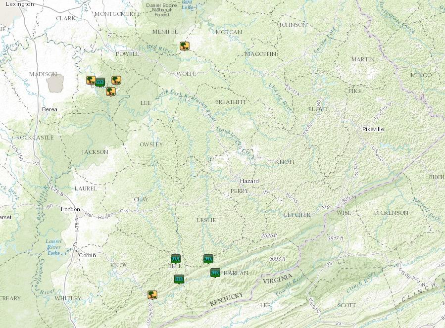 |
| Local storm reports from 6/21/2016. |
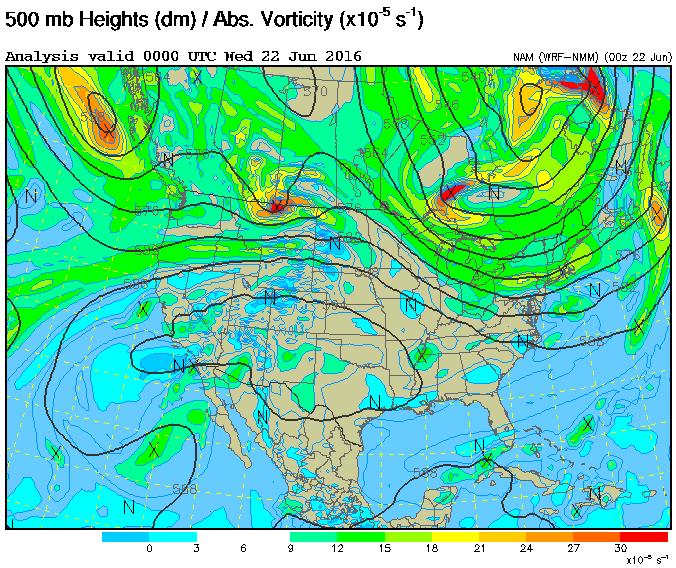
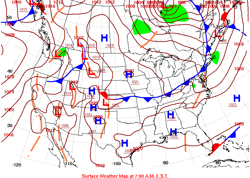
Environment
 |
 |
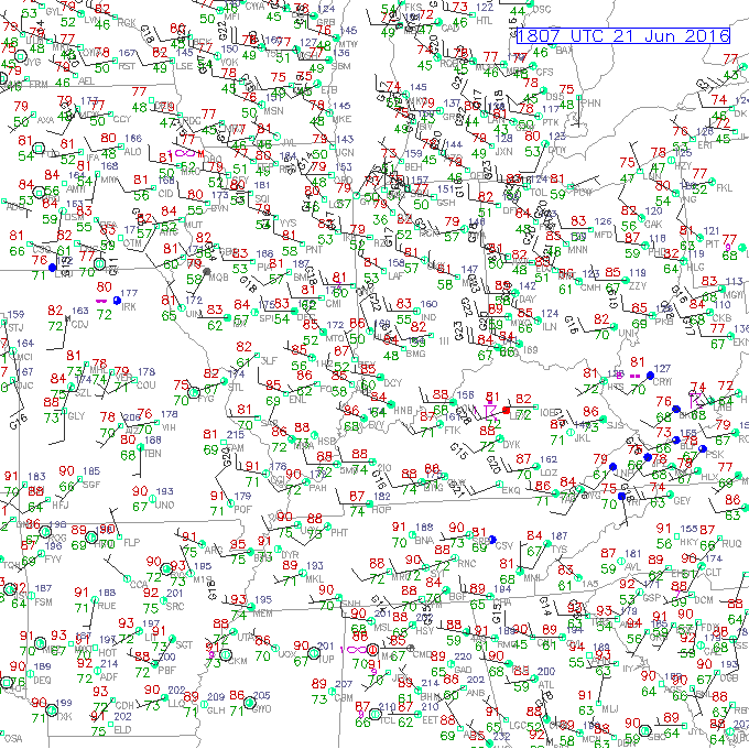 |
| An upper level disturbance across Ontario helped to provide the forcing aloft for thunderstorm development. | A cold front approached eastern Kentucky during the afternoon, providing additional forcing for thunderstorms. | A warm and very moist airmass was in place by early to mid afternoon, shown by temperatures in the mid 80s and dewpoints in the low 70s. |
 |
Media use of NWS Web News Stories is encouraged! Please acknowledge the NWS as the source of any news information accessed from this site. |
|

