
Heat expands across the Desert Southwest, Plains, Mississippi Valley and Midwest into Monday. Fire weather concerns continue for portions of the Intermountain West. Active monsoonal moisture fuels thunderstorms over the Southwest with possible flash flooding. Tropical cyclone Fausto in the Pacific, should weaken as it approaches Hawaii; Dangerous surf, swells and rip currents are expected. Read More >
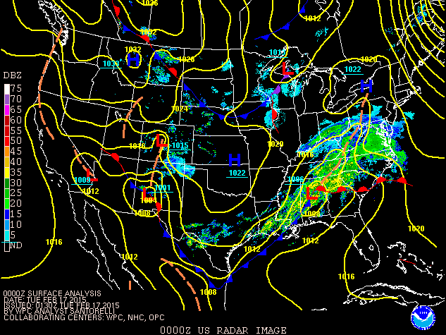
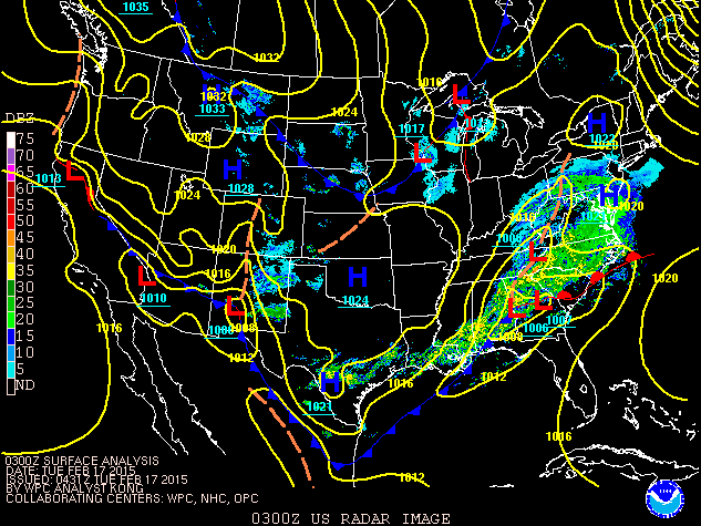
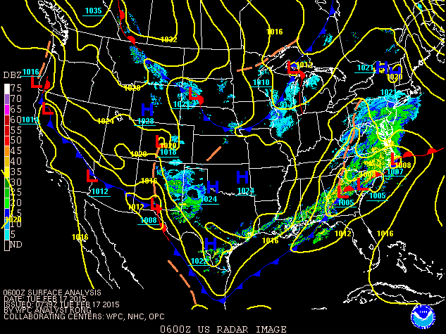
Low pressure tracking across Mississippi, Alabama and Georgia brought a roughly 12 hour period of moderate to heavy snow to most of the state of Kentucky from Sunday night into Monday February 16, 2015.
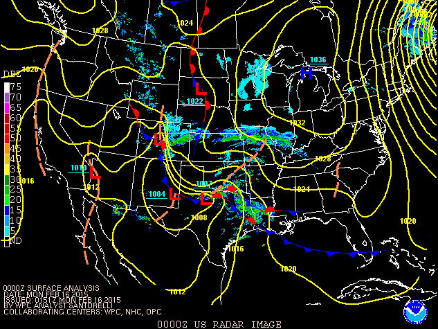
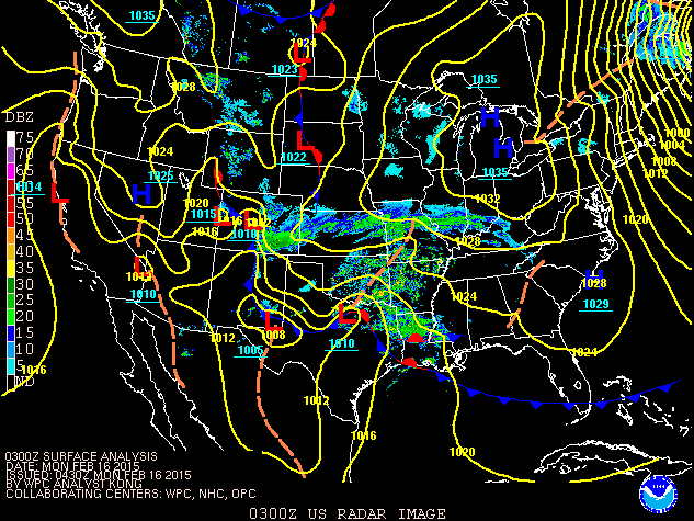
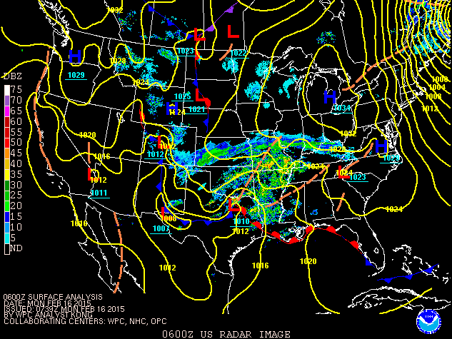
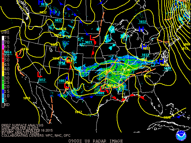
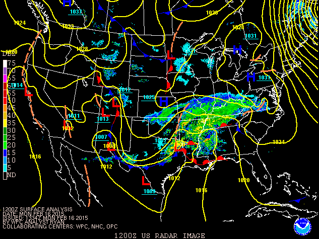
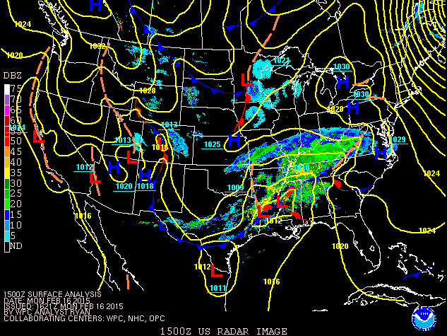
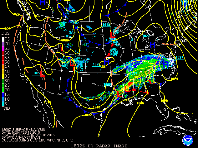
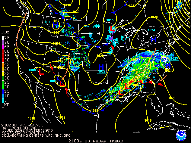
|
| Loop of Surface Analysis and Radar Image from 7 pm EST Sunday 2/15/2015 through 1 am EST Tuesday 2/17/2015 |
The snow fell with temperatures in the teens to low 20s for most locations resulting in a powdery snow. Snowfall amounts of 8 to 12" were common across eastern Kentucky, with a stripe of 12 to 18" across the heart of central and eastern Kentucky. For many areas, this was the most snow received in over a decade. A period of sleet and freezing rain mixing in with the snow cut into the snowfall amounts along the Tennessee border where 4 to 8" of snow was the rule.
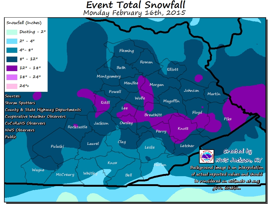
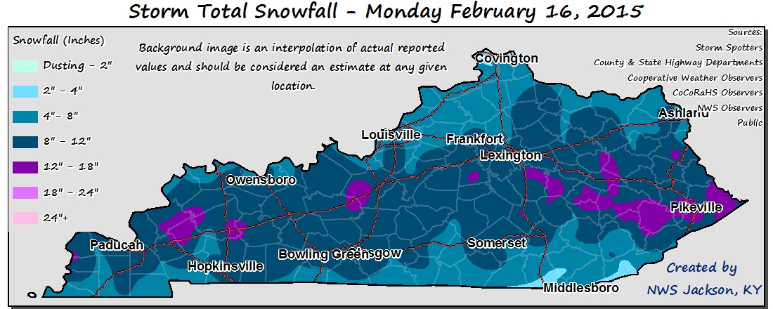
Below is a listing of some of the largest snowfall totals from reports received by NWS Jackson, KY through 11 pm February 16th...
LOCATION                     AMOUNT    TIME/DATE

...BATH COUNTY...
POLKSVILLE                   10.5 IN   0545 PM 02/16

...BELL COUNTY...
BEVERLY                      7.6 IN    0930 PM 02/16
FRAKES                       5.0 IN    1047 PM 02/16

...BREATHITT COUNTY...
CLAYHOLE                     14.2 IN   1039 PM 02/16
1 N FROZEN CREEK             14.0 IN   0950 PM 02/16
JACKSON                      12.5 IN   1000 PM 02/16
JACKSON                      12.0 IN   0630 PM 02/16
LAWSON                       11.6 IN   0734 PM 02/16
4 ENE JACKSON (NWS OFFICE)   11.1 IN   0650 PM 02/16
1 S FIVEMILE                 11.0 IN   0630 PM 02/16


...CLAY COUNTY...
MANCHESTER                   9.0 IN    0654 PM 02/16

...ELLIOTT COUNTY...
3 W BRUIN                    9.0 IN    0630 PM 02/16

...ESTILL COUNTY...
IRVINE                       14.0 IN   0803 PM 02/16
1 NW LOCUST BRANCH           12.0 IN   0554 PM 02/16

...FLEMING COUNTY...
FLEMINGSBURG                 9.0 IN    0547 PM 02/16
EWING                        8.0 IN    0547 PM 02/16

...FLOYD COUNTY...
ESTILL                       14.0 IN   0605 PM 02/16
EMMA                         12.0 IN   0915 PM 02/16
1 NW CLIFF                   11.8 IN   1020 PM 02/16
2 ENE DOTSON                 11.3 IN   0635 PM 02/16

...HARLAN COUNTY...
BLEDSOE                      8.0 IN    0950 PM 02/16

...JACKSON COUNTY...
MCKEE                        10.0 IN   0540 PM 02/16
1 ESE MAULDEN                9.5 IN    0800 PM 02/16

...JOHNSON COUNTY...
PAINTSVILLE                  12.0 IN   0700 PM 02/16

...KNOTT COUNTY...
FISTY                        16.5 IN   0959 PM 02/16
TOPMOST                      15.0 IN   0946 PM 02/16

...LEE COUNTY...
BEATTYVILLE                  14.0 IN   0600 PM 02/16
IDAMAY                       13.8 IN   0700 PM 02/16
2 SSW MOUNT OLIVE            12.0 IN   0545 PM 02/16

...LETCHER COUNTY...
THORNTON                     9.0 IN    0600 PM 02/16

...MENIFEE COUNTY...
FRENCHBURG                   11.0 IN   0623 PM 02/16

...MORGAN COUNTY...
1 W CANNEL CITY              11.0 IN   0600 PM 02/16

...PERRY COUNTY...
2 E BULAN                    17.0 IN   0912 PM 02/16
DICE                         15.3 IN   0953 PM 02/16
VIPER                        10.0 IN   1018 PM 02/16

...PIKE COUNTY...
2 W COLEMAN                  18.0 IN   1000 PM 02/16
PHELPS                       14.0 IN   0700 PM 02/16
PIKEVILLE                    14.0 IN   0550 PM 02/16
2 S GARDEN VILLAGE           13.5 IN   0800 PM 02/16
1 SE HATFIELD STATION        12.0 IN   0755 PM 02/16
VIRGIE                       9.5 IN    0600 PM 02/16

...POWELL COUNTY...
2 SW BOWEN                   11.2 IN   0615 PM 02/16

...PULASKI COUNTY...
BURNSIDE                     11.0 IN   1016 PM 02/16
4 ESE ELIHU                  7.6 IN    0735 PM 02/16

...ROCKCASTLE COUNTY...
MUELLERSVILLE                12.0 IN   0540 PM 02/16
LIVINGSTON                   11.0 IN   0640 PM 02/16

...WAYNE COUNTY...
1 NNW CABELL                 7.0 IN    0600 PM 02/16

...WOLFE COUNTY...
HAZEL GREEN                  15.0 IN   1024 PM 02/16
ROGERS                       11.0 IN   0600 PM 02/16
PINE RIDGE                   10.0 IN   0645 PM 02/16

