
Heat expands across the Desert Southwest, Plains, Mississippi Valley and Midwest into Monday. Fire weather concerns continue for portions of the Intermountain West. Active monsoonal moisture fuels thunderstorms over the Southwest with possible flash flooding. Tropical cyclone Fausto in the Pacific, should weaken as it approaches Hawaii; Dangerous surf, swells and rip currents are expected. Read More >
Jackson, KY
Weather Forecast Office
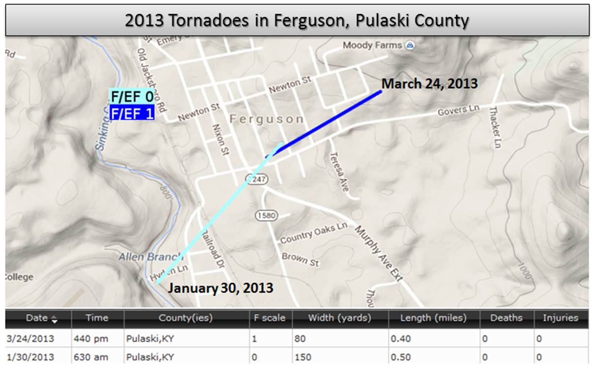
The Ferguson community in Pulaski County was hit by two tornadoes in 2013. The first tornado, an EF-0 with peak winds of 65 to 75 mph, occurred on January 30th. The tornado touched down near the end of Lake Cumberland Regional Airport runway and then traveled a half mile through a residential area causing some roof and siding damage and downing several trees. This tornado has the distinction of being the first documented tornado to have occurred in eastern Kentucky during the month of January.
The second tornado occurred on March 24th. This EF-1 tornado with estimated peak winds of around 100 mph amazingly touched down near the end of the January tornado's path, destroying a warehouse building on Waddle Street that was also damaged during the January tornado. The tornado then continued approximately 700 yards causing additional structure damage and downing multiple trees along it's path.
Fortunately, no deaths or injuries were reported with either tornado.
Warnings/Hazards
Decision Support - Outlooks
Current Weather Hazards
Hazards Criteria
Weather Story Graphic
Recent Storm Reports
Submit a Report
Forecasts
Decision Support - Forecast
Aviation Forecasts
Fire Weather Forecasts
Hourly Weather Forecast
Activity Planner
River Forecasts
Forecast Discussion
Current Conditions
Regional Radar
Decision Support - Current
Rivers and Lakes
Hourly Airport Weather
Local Radar
Satellite
Kentucky Mesonet
Past Weather
Local Climate Info
Temp/Precip Summary
How Much Rain Fell?
How Much Snow Fell?
Past Weather Events
Drought Information
Local Coop Observers
US Dept of Commerce
National Oceanic and Atmospheric Administration
National Weather Service
Jackson, KY
1329 Airport Road
Jackson, KY 41339
606-666-8000
Comments? Questions? Please Contact Us.

