
Heat expands across the Desert Southwest, Plains, Mississippi Valley and Midwest into Monday. Fire weather concerns continue for portions of the Intermountain West. Active monsoonal moisture fuels thunderstorms over the Southwest with possible flash flooding. Tropical cyclone Fausto in the Pacific, should weaken as it approaches Hawaii; Dangerous surf, swells and rip currents are expected. Read More >
Overview
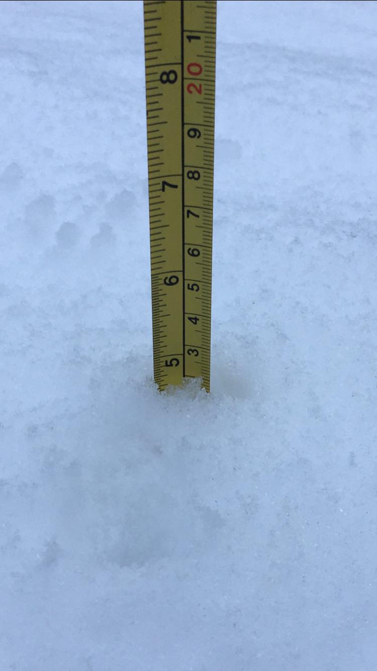
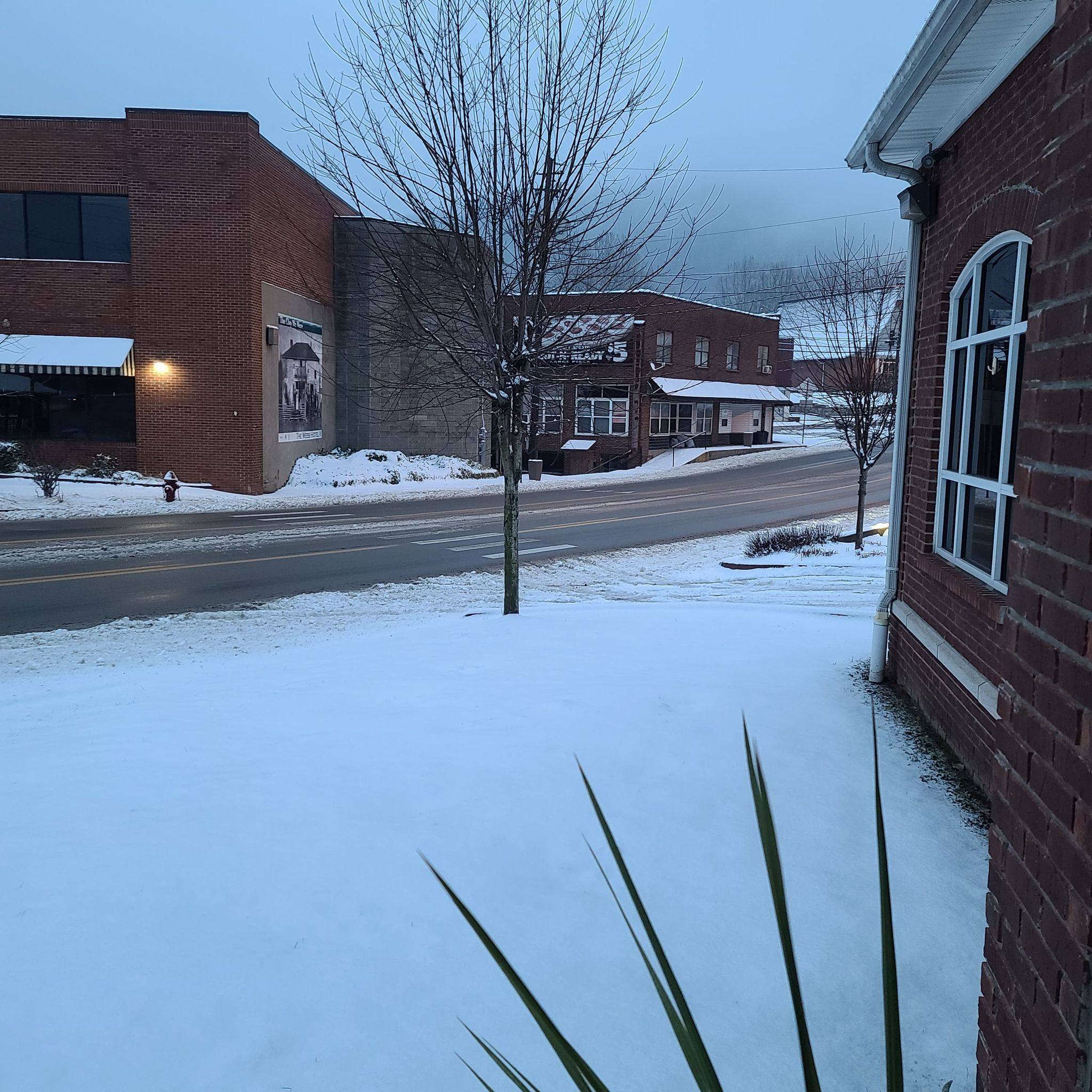
A weather disturbance pushing across east Kentucky led to widespread snow from the evening of February 17th through the early morning hours of February 18th. For most areas, 3 to 5 inches of snow were reported. This snowfall led to difficult travel during the overnight hours into the early morning hours. In addition, there were some additional power outages caused by breaking trees during the day on the 18th. Many of these trees still had ice on them from the past week. Difficult travel conditions were also noted during the overnight hours from the 17th to the 18th.Photos
 |
 |
 |
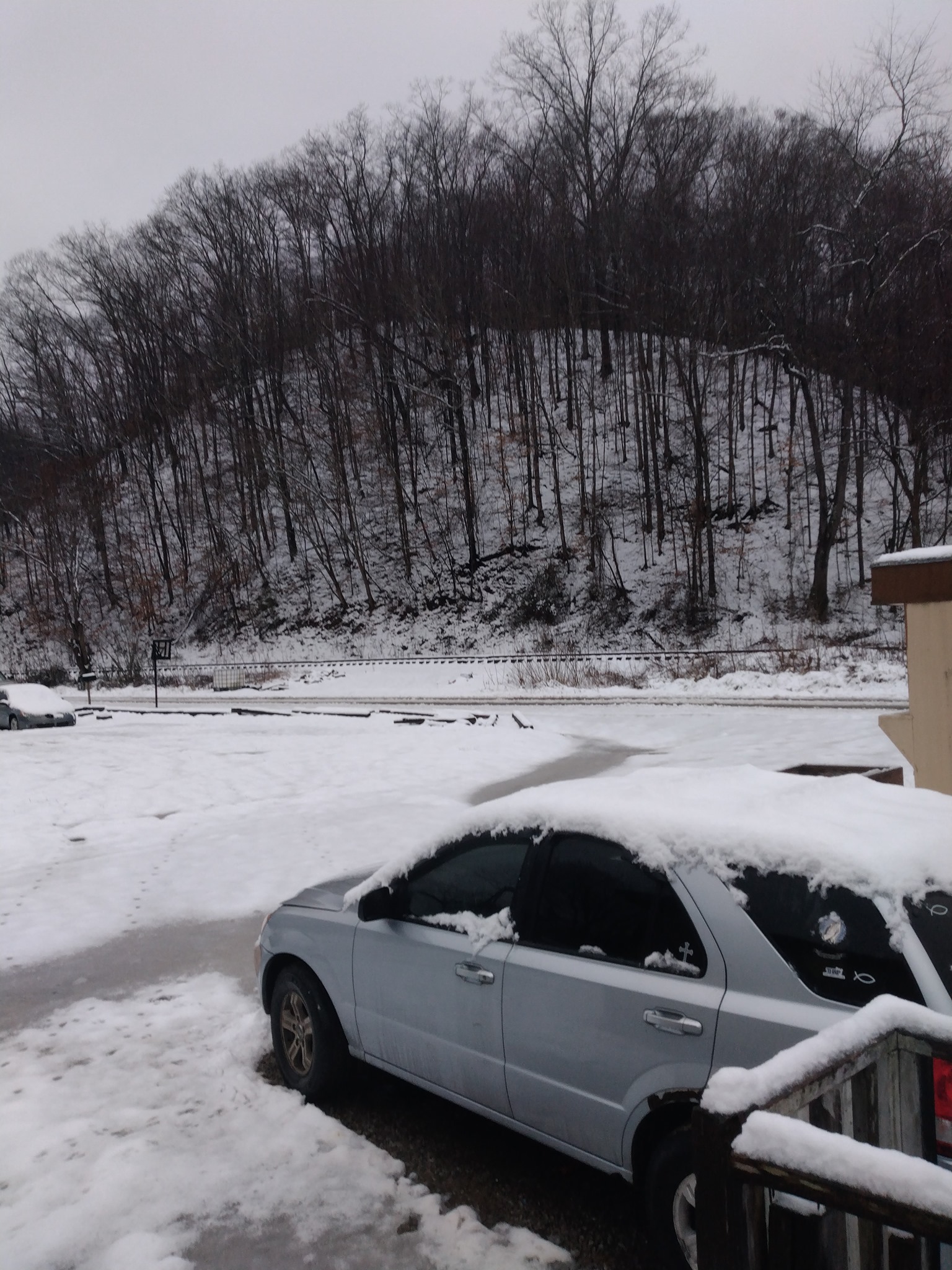 |
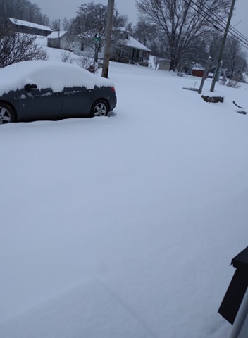
| Campton (Amanda) |
Johnson County (Dawn) |
Gordon (Rachel) |
Harlan (Robin) |
 |
 |
 |
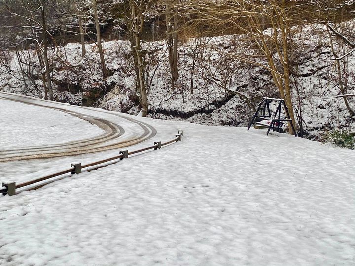
| Magoffin County (Jarrod) |
Raccoon (Kayla) |
Manchester (Ryan) |
| Local Storm Reports received from the morning of February 18th, 2021 | ||
 |
||
SNOWFALL REPORTS

Location                     Amount    Time/Date       Lat/Lon

...Bath County...
Owingsville                  3.8 in    0813 AM 02/18   38.14N/83.76W

...Bell County...
Fonde                        5.0 in    0700 AM 02/18   36.60N/83.88W
1 ENE Pineville              3.0 in    0200 AM 02/18   36.76N/83.69W
Middlesboro                  3.0 in    0239 AM 02/18   36.61N/83.72W
2 ESE Clear Creek Spring     3.0 in    0700 AM 02/18   36.72N/83.70W
1 NW Beverly                 1.0 in    1148 PM 02/17   36.94N/83.54W

...Breathitt County...
Canoe                        5.0 in    0834 AM 02/18   37.45N/83.45W
1 W Jackson                  3.1 in    1115 AM 02/18   37.56N/83.39W
NWS Office/Julian Carroll Ai 2.9 in    0312 AM 02/18   37.59N/83.31W
Inverness                    2.1 in    0105 AM 02/18   37.54N/83.36W
Lawson                       2.0 in    0500 AM 02/18   37.60N/83.46W

...Clay County...
1 N Manchester               4.2 in    0319 AM 02/18   37.16N/83.77W
Oneida                       2.3 in    0940 AM 02/18   37.27N/83.65W

...Elliott County...
Sandy Hook                   4.5 in    0800 AM 02/18   38.09N/83.13W

...Estill County...
Irvine                       5.0 in    0209 AM 02/18   37.70N/83.97W
Cressy                       3.1 in    0800 AM 02/18   37.83N/84.04W

...Floyd County...
Prestonsburg                 3.5 in    0250 AM 02/18   37.67N/82.77W
Dotson                       3.0 in    0725 AM 02/18   37.65N/82.86W
1 NNE Wheelwright            2.8 in    0153 AM 02/18   37.35N/82.72W

...Harlan County...
Smith                        4.0 in    0400 AM 02/18   36.74N/83.26W
Fresh Meadows                4.0 in    0530 AM 02/18   36.84N/83.37W
Coburn                       3.5 in    0242 AM 02/18   36.81N/83.31W
Dressen                      2.0 in    0700 AM 02/18   36.83N/83.33W

...Jackson County...
2 ESE Kerby Knob             3.5 in    1101 PM 02/17   37.52N/84.09W
Mckee                        3.5 in    0150 AM 02/18   37.43N/84.00W

...Johnson County...
Thealka                      4.0 in    0650 AM 02/18   37.82N/82.79W
Paintsville                  2.0 in    0317 AM 02/18   37.82N/82.81W

...Knott County...
2 SE Hindman                 2.0 in    0120 AM 02/18   37.32N/82.96W

...Knox County...
Barbourville                 4.0 in    0700 AM 02/18   36.87N/83.88W
Hinkle                       2.5 in    0130 AM 02/18   36.91N/83.82W
Gray                         1.9 in    0800 AM 02/18   36.94N/84.01W

...Laurel County...
1 NNE Wood Creek Lake        4.0 in    0250 AM 02/18   37.22N/84.18W
East Bernstadt               3.5 in    0237 AM 02/18   37.19N/84.12W
London                       3.5 in    0252 AM 02/18   37.13N/84.08W

...Lee County...
2 ESE Pinnacle               4.8 in    0110 AM 02/18   37.61N/83.79W

...Leslie County...
Yeaddiss                     4.0 in    0700 AM 02/18   37.07N/83.22W
Hyden                        3.0 in    0322 AM 02/18   37.16N/83.37W

...Letcher County...
1 E Payne Gap                3.5 in    0500 AM 02/18   37.16N/82.64W
1 N Oven Fork                3.5 in    0500 AM 02/18   37.08N/82.81W
1 SSW Ermine                 3.0 in    0700 AM 02/18   37.10N/82.80W
1 NNW Farraday               2.5 in    0140 AM 02/18   37.17N/82.78W
Whitesburg                   2.5 in    0253 AM 02/18   37.12N/82.83W
Lilley Cornett Woods         2.2 in    0800 AM 02/18   37.09N/82.99W

...Magoffin County...
Cutuno                       3.0 in    0600 AM 02/18   37.72N/83.24W
1 S Salyersville             2.5 in    0700 AM 02/18   37.74N/83.07W

...Martin County...
1 WNW Inez                   3.8 in    0805 AM 02/18   37.87N/82.56W

...McCreary County...
Whitley City                 3.5 in    0829 AM 02/18   36.72N/84.47W

...Menifee County...
Frenchburg                   4.2 in    0244 AM 02/18   37.95N/83.63W

...Montgomery County...
1 S Oggs Station             4.0 in    0816 AM 02/18   38.01N/83.82W

...Morgan County...
1 NNE West Liberty           3.5 in    0453 AM 02/18   37.92N/83.26W

...Owsley County...
1 WNW Booneville             4.0 in    0818 AM 02/18   37.48N/83.70W

...Perry County...
Hazard                       3.0 in    0700 AM 02/18   37.25N/83.20W
1 ESE Hazard                 3.0 in    0700 AM 02/18   37.25N/83.18W
3 W Bulan                    2.0 in    0323 AM 02/18   37.30N/83.22W

...Pike County...
3 W Mouthcard                4.0 in    0200 AM 02/18   37.38N/82.31W
Coal Run                     3.5 in    0300 AM 02/18   37.52N/82.56W
2 NW Board Tree              3.0 in    0315 AM 02/18   37.57N/82.19W
Pikeville                    1.0 in    0130 AM 02/18   37.48N/82.52W

...Powell County...
Stanton                      5.0 in    0228 AM 02/18   37.85N/83.86W
1 NW Koomer Ridge Camping Gr 5.0 in    0230 AM 02/18   37.80N/83.65W
2 E Clay City                3.6 in    0800 AM 02/18   37.86N/83.90W
Waltersville                 3.0 in    0800 AM 02/18   37.87N/83.93W

...Pulaski County...
5 NE Eubank                  4.5 in    1045 AM 02/18   37.33N/84.59W
2 S Science Hill             4.3 in    0120 AM 02/18   37.15N/84.64W
1 NNE Somerset               4.2 in    0400 AM 02/18   37.09N/84.60W

...Rockcastle County...
Brodhead                     6.0 in    0105 AM 02/18   37.40N/84.42W
1 ESE Mount Vernon           3.5 in    1012 PM 02/17   37.36N/84.32W

...Rowan County...
1 S Morehead                 4.5 in    0248 AM 02/18   38.18N/83.44W
2 SSE Farmers                3.0 in    0800 AM 02/18   38.12N/83.53W
Morehead                     1.5 in    1045 PM 02/17   38.19N/83.44W

...Wayne County...
1 SSW Monticello             3.5 in    0250 AM 02/18   36.83N/84.85W

...Whitley County...
Corbin                       3.5 in    0215 AM 02/18   36.94N/84.11W
1 NE Williamsburg            1.8 in    0157 AM 02/18   36.74N/84.16W

...Wolfe County...
Koomer Ridge Camping Ground  5.0 in    0225 AM 02/18   37.78N/83.63W
1 SSW Murphyfork             3.2 in    1130 AM 02/18   37.81N/83.43W
Environment
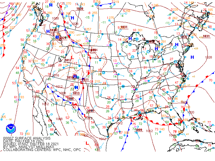 |
| Surface Analysis (7 PM, February 17th - 4 AM, February 18th) |
 |
Media use of NWS Web News Stories is encouraged! Please acknowledge the NWS as the source of any news information accessed from this site. |
|

