Key Points:
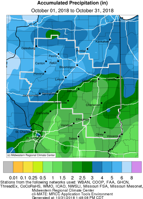
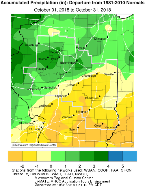
- October 2018 monthly rainfall was above normal north of I-72, and below normal along and south of I-72. The wet periods were from Oct 4-15th and again during the last week of the month from Oct 25-31st. A nice stretch of dry weather was noted from Oct 16-24th to assist with the harvesting of corn and soybeans. The highest surpluses of rainfall were from Lincoln northward where some areas were twice their normal rainfall. Lincoln and Peoria had their 4th and 6th wettest Octobers on record respectively. The Bloomington-Normal area had close to 7 inches of precipitation during the month with half of that falling from Oct 5-7th. We had a few reports of wind damage from severe thunderstorms in DeWitt and Vermilion counties on early Saturday afternoon Oct 6th. Meanwhile areas like Champaign and Decatur southward into southeast IL, only had 1 to 2.5 inches of rainfall, which was 1 to 2.5 inches below their normal levels. Wind advisories were issued across much of Illinois on Saturday Oct 20th and again on Sunday Oct 28th with wind gusts of 45 to 60 mph blowing down some trees and branches along with power outages. Even some field fires were ignited on Saturday afternoon Oct 20th caused by farm equipment harvesting the dry windy fields.
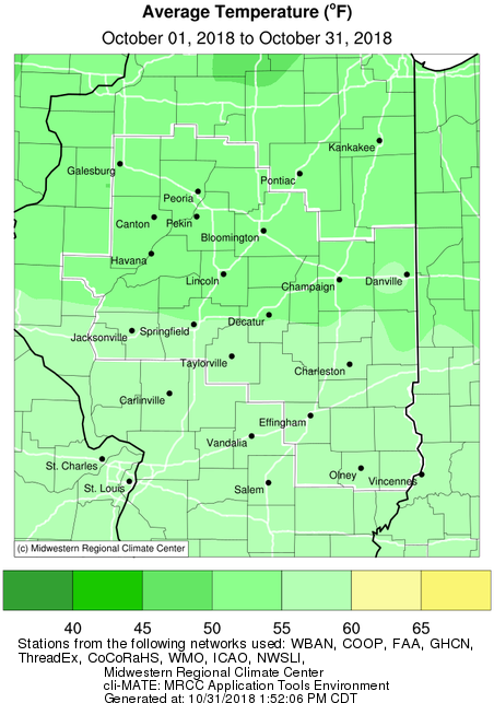
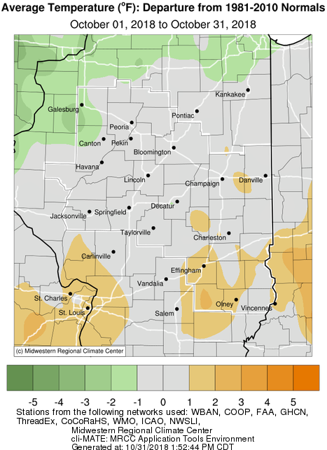
- October 2018 monthly temperatures were close to normal across much of central IL. Though southeast IL trended near or slightly above normal temperatures, while areas northwest of the IL river trended near or slightly below normal temperatures. Above normal temperatures were noted from Oct 1-10th, with Wednesday Oct 3rd being the warmest day when summerlike highs reached near 90 degrees across the area. Then a long stretch of below normal temperatures was observed from Oct 11-29th. Friday Oct 12th was the coldest daytime temperatures in central IL, when highs only reached around 40 degrees in central IL from I-72 north. We even had snow showers that Friday afternoon bringing a trace to a couple tenth inch of snow on grassy and elevated surfaces. Central IL's first freeze was observed early Tuesday morning Oct 16th and again early Thursday morning Oct 18th when lows reached around 30 degrees. A widespread hard freeze was observer over central and southeast IL early Sunday morning Oct 21st when lows reached the 20s. The Champaign, Lincoln and Springfield airports reached 21 degrees, with Springfield setting a record low. This was the coldest morning in central IL since March 7th. After a 2.5 week cool period, temperatures warmed into the 70s on Tuesday Oct 30th, with breezy south winds and return of some sunshine by that Tuesday afternoon. Much of central IL enjoyed a dry and seasonable cool Halloween evening, while wet conditions prevailed over southeast IL.
Precipitation, Temperature, and Departure from Normal Maps:


Climate Data:
|
Site
|
Precipitation
|
Departure from Normal |
Average Temperature
|
Departure from Normal |
|
Charleston
|
2.63" |
-1.13" |
57.7 |
+1.4 |
| Danville |
3.05"
|
-0.52" |
55.8 |
+0.8 |
| Decatur |
2.31"
|
-0.94 |
55.0 |
-1.2 |
| Effingham |
1.07"
|
-2.52" |
57.4 |
+2.1 |
|
Flora
|
1.32" |
-2.35" |
57.7 |
+2.4 |
| Galesburg |
3.70"
|
+0.95" |
50.3 |
-2.2 |
|
Havana
|
5.92" |
+2.88" |
N/A |
N/A |
|
Jacksonville
|
4.06" |
+0.87" |
55.4 |
+0.1 |
| Lincoln |
6.11" |
+3.03" |
53.5 |
-0.3
|
|
Normal
|
6.85"
|
+3.57" |
53.1 |
0.0 |
|
Olney
|
1.82" |
-2.17" |
57.2 |
+1.0 |
|
Paris
|
2.56" |
-0.82" |
54.6 |
-0.2 |
| Peoria |
5.33" |
+2.49" |
53.7 |
-0.3 |
| Springfield |
3.33"
|
+0.18" |
54.9 |
-0.2 |
|
Tuscola
|
2.12 |
-1.13" |
54.9 |
+0.5 |
| Urbana |
2.29"
|
-0.97" |
54.5 |
+0.6 |
Links below are the monthly climate summaries for area cities. Only the summaries for Peoria, Springfield and Lincoln are considered "official", meaning they are the station of record for their respective locations. The other summaries are "supplemental", meaning another location in the area is the official climate station for that city.
Climate data for other area cities is available at http://www.nws.noaa.gov/climate/xmacis.php?wfo=ilx