Overview
|
An early-season severe weather outbreak took shape across southeast Illinois during the afternoon of February 19 and persisted into the evening hours. The region along and immediately south of Interstate 70 saw the highest concentration of severe weather with preliminary reports indicating at least a couple tornadoes were observed across Effingham and Crawford counties. The most severe structural damage was reported near New Hebron in Crawford County. |
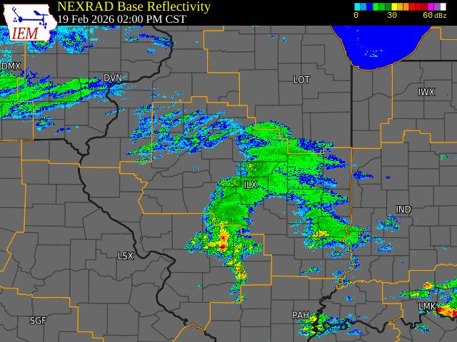 February 19, 2026 radar loop with National Weather Service warnings overlayed. |
Tornadoes
Select a tornado from the table to zoom into the track and view more information. The default table view is limited to 8 tracks, but can be scrolled by a mouse wheel or dynamically expanded. Additionally, the table can fill the entire window by clicking the small circular expanding arrow icon at the very top right of the table and returned to its original size by clicking the button again. The side information panel that opens over the map can be closed using the "X" on the upper right corner of the pop-up. Zoom into the map and click damage points to see detailed information and pictures from the surveys.
|
NOTE: times shown below are local to your device's time zone. |

The Enhanced Fujita (EF) Scale classifies tornadoes into the following categories:
| EF0 Weak 65-85 mph |
EF1 Moderate 86-110 mph |
EF2 Significant 111-135 mph |
EF3 Severe 136-165 mph |
EF4 Extreme 166-200 mph |
EF5 Catastrophic 200+ mph |
 |
|||||
| Tornadoes that fail to impact any ratable damage indicators on the EF-Scale are rated EF-Unknown (EF-U) | |||||
Storm Reports
Preliminary Local Storm Report...Summary
National Weather Service Lincoln IL
1139 PM CST Fri Feb 20 2026

..TIME...   ...EVENT...      ...CITY LOCATION...     ...LAT.LON...
..DATE...   ....MAG....      ..COUNTY LOCATION..ST.. ...SOURCE....
            ..REMARKS..

0259 PM     Tornado          1 SSE Edgewood          38.91N 88.66W
02/19/2026                   Clay               IL   NWS Storm Survey

            EF0, peak wind speed 75 mph, path length 3.0
            miles. The tornado touched down just south
            of the Clay and Effingham county line, near
            the Edgewood Rd. curve, and tracked
            northeast. Damage was limited to tree
            branches.

0309 PM     Tornado          3 NNW Chauncey          38.88N 87.89W
02/19/2026                   Crawford           IL   NWS Storm Survey

            EFU, brief touch down in an open field.

0316 PM     Tstm Wnd Dmg     1.5 SW Watson           39.01N 88.59W
02/19/2026                   Effingham          IL   Broadcast Media

            *** 1 INJ ***
            Corrects previous tstm wnd dmg report from
            1.5 SW Watson. Seven vehicle accident due to
            thunderstorm winds. 1 injury.

0323 PM     Tornado          2 SW Wheeler            39.02N 88.34W
02/19/2026                   Jasper             IL   NWS Storm Survey

            EFU, brief touch down in an open field.

0337 PM     Hail             Dieterich               39.06N 88.38W
02/19/2026  M2.50 Inch       Effingham          IL   Public

            Delayed report. Time estimated by radar.
            Report relayed by broadcast media.

0338 PM     Hail             Dieterich               39.06N 88.38W
02/19/2026  M2.00 Inch       Effingham          IL   Broadcast Media


0338 PM     Hail             1 W Dieterich           39.06N 88.40W
02/19/2026  E1.00 Inch       Effingham          IL   Public

            Report from mPING: Quarter (1.00 in.).

0339 PM     Hail             Dieterich               39.06N 88.38W
02/19/2026  E1.25 Inch       Effingham          IL   Public

            Report from mPING: Half Dollar (1.25 in.).

0344 PM     Hail             Dieterich               39.06N 88.38W
02/19/2026  M1.75 Inch       Effingham          IL   Broadcast Media

            Half dollar to ping pong size hail with some
            golf ball size hailstones.

0346 PM     Funnel Cloud     Wheeler                 39.04N 88.32W
02/19/2026                   Jasper             IL   Storm Chaser

            Social media report with photo of funnel
            cloud.

0401 PM     Hail             1 NNE Casey             39.31N 87.99W
02/19/2026  M1.00 Inch       Clark              IL   Public

            Pea to quarter size hail for about 4 minutes
            and covering the ground.

0407 PM     Funnel Cloud     4 W Chauncey            38.84N 87.95W
02/19/2026                   Richland           IL   Storm Chaser

            Delayed report. Video shows a well-defined
            funnel cloud at least halfway to the ground,
            viewed from County Road 10 looking west from
            near Chauncey. NWS damage survey team will
            be investigating this area.

0412 PM     Hail             Yale                    39.12N 88.03W
02/19/2026  M1.25 Inch       Jasper             IL   Public

            Delayed report. Time estimated by radar.
            Report relayed by broadcast media.

0416 PM     Hail             1 S Martinsville        39.32N 87.88W
02/19/2026  E1.00 Inch       Clark              IL   Public

            Delayed report. Quarter size hail reported
            via social media. Time estimated from radar.

0416 PM     Hail             Hardinville             38.92N 87.84W
02/19/2026  M1.00 Inch       Crawford           IL   Public


0420 PM     Tornado          3 NW Flat Rock          38.93N 87.71W
02/19/2026                   Crawford           IL   NWS Storm Survey

            *** 1 INJ ***
            EF1, 110 mph, path length 5.0 miles. The
            most significant damage occurred to two
            homes, one mobile home was thrown off its
            foundation and wrapped around a tree
            injuring an elderly woman who was taken to
            the hospital with serious injuries.

0421 PM     Hail             1 N Bellair             39.15N 87.95W
02/19/2026  E1.00 Inch       Crawford           IL   Public

            Social media report. Time estimated from
            radar.

0425 PM     Hail             4 S Robinson            38.95N 87.74W
02/19/2026  M1.00 Inch       Crawford           IL   Public

            Social media report. Copious amounts of
            hail.

0432 PM     Tornado          1 NNE Annapolis         39.16N 87.81W
02/19/2026                   Crawford           IL   NWS Storm Survey

            EFU, Video of a brief touchdown in an open
            field from a storm chaser.

0438 PM     Tstm Wnd Gst     Robinson Municipal Airp 39.01N 87.65W
02/19/2026  M51 MPH          Crawford           IL   AWOS

            Robinson airport measured westerly wind gust
            of 51 mph.

0439 PM     Hail             York                    39.17N 87.64W
02/19/2026  M0.88 Inch       Clark              IL   Trained Spotter


0443 PM     Funnel Cloud     York                    39.17N 87.64W
02/19/2026                   Clark              IL   Public

            Delayed report from social media. Time
            estimated from radar.

0615 PM     Tornado          3 NNW Bible Grove       38.91N 88.46W
02/19/2026                   Clay               IL   NWS Storm Survey

            EF0, 75 mph, path length 4.1 miles. Much of
            the damage was concentrated at a farmstead
            along the Clay/Effingham county line east of
            1800th St. Metal from the top of a silo was
            blown off, and a barn was damaged with roof
            pieces blown northeast for about a half
            mile. Tracks through corn stubble in fields
            was found until reaching E. 200th Ave. west
            of county road 2200.

0628 PM     Hail             Ray                     40.21N 90.48W
02/19/2026  M1.00 Inch       Schuyler           IL   Emergency Mngr


0658 PM     Funnel Cloud     2 W Newton              38.99N 88.20W
02/19/2026                   Jasper             IL   Storm Chaser


0725 PM     Hail             4 SW Manito             40.39N 89.83W
02/19/2026  M1.25 Inch       Mason              IL   Broadcast Media

            Half dollar size hail at Sand Ridge State
            Forest.

0745 PM     Hail             Bellevue                40.68N 89.68W
02/19/2026  M1.00 Inch       Peoria             IL   Trained Spotter


0759 PM     Hail             2 W Tremont             40.53N 89.53W
02/19/2026  M1.00 Inch       Tazewell           IL   Broadcast Media


&&

$$
Radar
Header
 |
 |
||
| Reflectivity (left) and Storm Relative Velocity (right) at 2200Z/4 PM showing four severe or tornado warned supercells in southeast IL. | Reflectivity (left) and Storm Relative Velocity (right) at 2225Z/4:25 PM from KVWX showing strong rotation NW of Flat Rock, IL | Caption | Caption |
Photos & Video
Header
 |
 |
 |
 |
| Funnel cloud around 3:43 PM southeast of Wheeler, IL. (Owen Szarley) |
Tornado West of Flat Rock ~425 PM. (Brian Emfinger) |
Tornado West of Flat Rock ~425 PM. (Brian Emfinger) |
Damage from the EF-1 Flat Rock tornado. (NWS Survey) |
Additional Information
The Forecast
 |
 |
 |
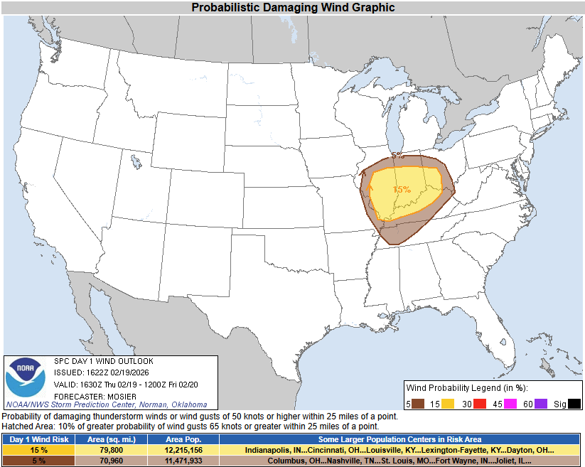 |
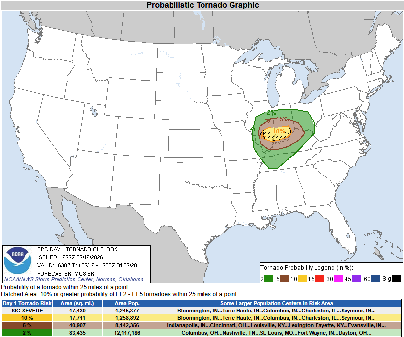
| SPC Day 1 12Z Categorical Outlook | SPC Day 1 1630Z Categorical Outlook - Upgraded to Enhanced Risk | SPC Day 1 1630Z Probabilistic Tornado Outlook | SPC Day 1 1630Z Probabilistic Wind Outlook |
 |
 |
 |
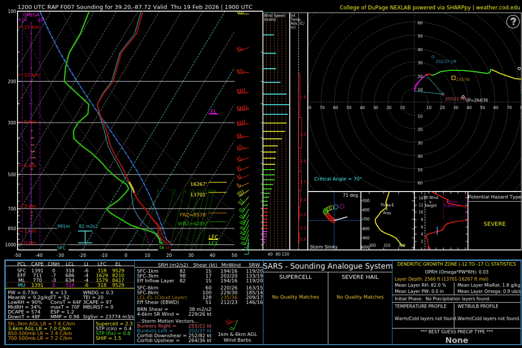 |
| SPC Day 1 Categorical Outlook | Tornado Watch Issued during the afternoon hours of Feb 19 | Graphical Outlook sent out by NWS Lincoln around 4 PM Feb 19 | 12Z RAP forecast sounding for a location south of I-70 (COD Meteorology) |
 |
Media use of NWS Web News Stories is encouraged! Please acknowledge the NWS as the source of any news information accessed from this site. |
|

