Overview
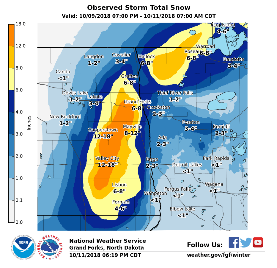
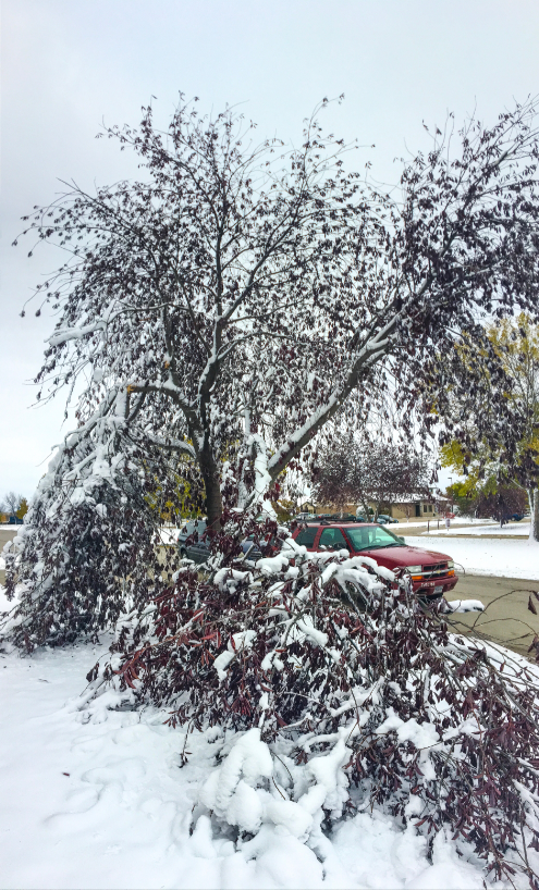
An early winter storm occurred in eastern North Dakota and northwest Minnesota on October 10 into the morning of October 11. This storm was defined by a band of snow in eastern North Dakota that provided over a foot snow for many locations. The highest total snowfall reports were from the Grand Forks AFB south to the Valley City area. This snow was wet and heavy unlike the dryer snow that we typically get in the winter. The wetter, heavier snow occurred because of the early time of the storm with warmer temperatures. The heavily weighted nature of this snow stuck to foliage remaining on trees causing some limbs to break under the snow's weight.Snow/Ice
Map below shows preliminary snowfall amounts from across the region. The narrow band of snow provided over a foot of snow for many locations in eastern North Dakota. The highest report came from Grand Forks Air Force Base west of Grand Forks with 17.4 inches of snow!
...SNOWFALL REPORTS FOR OCTOBER 10-11, 2018...

LOCATION                     AMOUNT    TIME/DATE       LAT/LON

...MINNESOTA...

...BECKER COUNTY...
5 NNW CORMORANT              2.2 IN    0700 AM 10/11   46.80N/96.10W
3 NE RICHWOOD                1.5 IN    0150 PM 10/10   47.01N/95.77W
3 ESE WESTBURY               1.1 IN    0700 AM 10/11   46.90N/95.84W

...BELTRAMI COUNTY...
PUPOSKY                      3.5 IN    0800 AM 10/11   47.68N/94.91W
4 NW LAVINIA                 2.0 IN    0800 AM 10/11   47.55N/94.88W
5 SSE PUPOSKY                2.0 IN    0800 AM 10/11   47.61N/94.88W
2 S SOLWAY                   2.0 IN    0700 AM 10/11   47.49N/95.13W
1 ENE BLACKDUCK              1.5 IN    0800 AM 10/11   47.73N/94.53W
4 E TURTLE RIVER             1.5 IN    0700 AM 10/11   47.59N/94.67W

...CLAY COUNTY...
SABIN                        3.1 IN    0600 AM 10/11   46.78N/96.65W
3 N MOORHEAD                 2.5 IN    0700 AM 10/11   46.91N/96.76W
HAWLEY                       1.0 IN    0909 AM 10/10   46.88N/96.32W

...CLEARWATER COUNTY...
2 NW SHEVLIN                 5.0 IN    0800 AM 10/11   47.55N/95.29W

...HUBBARD COUNTY...
5 SSE DORSET                 0.9 IN    0800 AM 10/11   46.89N/94.89W

...KITTSON COUNTY...
2 ESE LAKE BRONSON           9.4 IN    0800 AM 10/11   48.72N/96.63W
KARLSTAD                     6.5 IN    1000 AM 10/11   48.58N/96.52W
LAKE BRONSON                 1.0 IN    0950 AM 10/10   48.73N/96.66W

...LAKE OF THE WOODS COUNTY...
10 W FAUNCE                  6.0 IN    0830 AM 10/11   48.61N/95.18W
BAUDETTE                     2.0 IN    0800 AM 10/11   48.71N/94.59W

...MAHNOMEN COUNTY...
NAYTAHWAUSH                  2.5 IN    1000 AM 10/11   47.26N/95.63W

...MARSHALL COUNTY...
4 WNW STRANDQUIST            11.0 IN   1000 AM 10/11   48.51N/96.52W
2 NW STRANDQUIST             11.0 IN   1000 AM 10/11   48.51N/96.47W
ARGYLE                       4.0 IN    0700 AM 10/11   48.34N/96.82W
1 WNW WARREN                 4.0 IN    0800 AM 10/11   48.20N/96.78W
5 N MARCH                    2.2 IN    0700 AM 10/11   48.27N/96.88W

...OTTER TAIL COUNTY...
5 SE HILLVIEW                3.0 IN    0800 AM 10/11   46.63N/95.19W
1 SW OTTERTAIL               1.5 IN    0450 AM 10/11   46.42N/95.57W
NEW YORK MILLS               0.5 IN    0700 AM 10/11   46.52N/95.37W

...PENNINGTON COUNTY...
5 WNW HIGH LANDING           1.1 IN    0700 AM 10/11   48.07N/95.91W

...POLK COUNTY...
ANGUS                        4.7 IN    1000 AM 10/11   48.08N/96.70W
FOSSTON                      3.5 IN    0800 AM 10/11   47.58N/95.75W
3 SSW MENTOR                 2.5 IN    0700 AM 10/11   47.66N/96.17W
CROOKSTON                    2.0 IN    0800 AM 10/11   47.77N/96.61W
6 SE MAPLE BAY               1.7 IN    0800 AM 10/11   47.58N/96.14W

...ROSEAU COUNTY...
GREENBUSH                    9.5 IN    0700 AM 10/11   48.70N/96.18W
WARROAD                      7.0 IN    0800 AM 10/11   48.91N/95.32W
3 W WARROAD                  4.5 IN    0536 PM 10/10   48.91N/95.39W
ROSEAU                       4.0 IN    0536 PM 10/10   48.85N/95.76W

...WADENA COUNTY...
SEBEKA                       1.0 IN    0700 AM 10/11   46.63N/95.09W

...WILKIN COUNTY...
3 SE BRECKENRIDGE            0.9 IN    0700 AM 10/11   46.23N/96.54W

...NORTH DAKOTA...

...BARNES COUNTY...
2 W LITCHVILLE               15.5 IN   0800 AM 10/11   46.66N/98.23W
3 S VALLEY CITY              13.0 IN   0200 PM 10/10   46.88N/98.01W
DAZEY                        12.2 IN   0800 AM 10/11   47.19N/98.20W
VALLEY CITY                  9.5 IN    1205 PM 10/10   46.92N/98.01W
2 W LITCHVILLE               8.5 IN    1129 AM 10/10   46.66N/98.23W
BALD HILL DAM                6.0 IN    1050 AM 10/10   47.03N/98.08W
4 W ORISKA                   5.8 IN    1142 AM 10/10   46.92N/97.88W

...CASS COUNTY...
2 NE CASSELTON               6.0 IN    0800 AM 10/11   46.92N/97.18W
TOWER CITY                   4.0 IN    1021 AM 10/10   46.93N/97.68W
3 S FARGO                    1.6 IN    0700 AM 10/11   46.83N/96.82W
1 S FARGO                    1.2 IN    1204 PM 10/10   46.86N/96.82W
FARGO                        0.8 IN    0100 PM 10/10   46.88N/96.82W

...CAVALIER COUNTY...
2 E LANGDON                  1.5 IN    0800 AM 10/11   48.76N/98.34W

...GRAND FORKS COUNTY...
GRAND FORKS AFB              17.4 IN   0800 AM 10/11   47.96N/97.38W
8 SSE LOGAN CENTER           14.0 IN   0658 AM 10/11   47.69N/97.76W
NORTHWOOD                    13.5 IN   0730 PM 10/10   47.74N/97.57W
LARIMORE                     12.5 IN   0858 PM 10/10   47.91N/97.63W
3 NW GILBY                   8.0 IN    0800 AM 10/11   48.11N/97.51W
5 WNW GRAND FORKS            6.5 IN    1130 PM 10/10   47.94N/97.17W
1 W GRAND FORKS              6.1 IN    0700 AM 10/11   47.92N/97.10W
KEMPTON                      5.0 IN    0955 AM 10/10   47.82N/97.61W
MCCANNA                      5.0 IN    1025 AM 10/10   48.01N/97.71W
GILBY                        4.5 IN    1025 AM 10/10   48.08N/97.47W
2 SE GRAND FORKS             3.0 IN    0217 PM 10/10   47.90N/97.05W
3 N ARVILLA                  3.0 IN    0730 AM 10/10   47.96N/97.49W

...GRIGGS COUNTY...
COOPERSTOWN                  12.0 IN   0845 PM 10/10   47.44N/98.12W
6 SSW ANETA                  7.0 IN    0200 PM 10/10   47.60N/98.03W
HANNAFORD                    5.0 IN    1015 AM 10/10   47.31N/98.19W

...NELSON COUNTY...
2 NNW PETERSBURG             7.5 IN    0800 AM 10/11   48.04N/98.01W
2 N PETERSBURG               7.0 IN    0356 PM 10/10   48.04N/98.00W
PETERSBURG                   7.0 IN    0205 PM 10/10   48.01N/98.00W
MICHIGAN                     6.0 IN    0700 AM 10/11   48.03N/98.12W
MCVILLE                      3.0 IN    1011 AM 10/10   47.77N/98.18W
2 N PEKIN                    2.0 IN    1011 AM 10/10   47.82N/98.33W

...PEMBINA COUNTY...
2 S SAINT THOMAS             4.0 IN    0254 PM 10/10   48.59N/97.45W
1 NNE BACKOO                 4.0 IN    0700 AM 10/11   48.85N/97.70W
3 W LEROY                    2.2 IN    1000 AM 10/11   48.92N/97.81W
DRAYTON                      2.0 IN    0930 AM 10/10   48.56N/97.18W
PEMBINA                      1.8 IN    0700 AM 10/11   48.97N/97.24W

...RAMSEY COUNTY...
STARKWEATHER                 1.0 IN    0700 AM 10/11   48.45N/98.87W

...RANSOM COUNTY...
1 N LISBON                   6.7 IN    0700 AM 10/11   46.45N/97.68W
LISBON                       4.0 IN    0115 PM 10/10   46.44N/97.68W

...RICHLAND COUNTY...
3 E MCLEOD                   8.3 IN    0845 AM 10/11   46.40N/97.24W
1 WSW LIDGERWOOD             3.0 IN    0700 AM 10/11   46.07N/97.17W
LIDGERWOOD                   1.0 IN    0222 PM 10/10   46.07N/97.15W
4 S MOORETON                 0.5 IN    0700 AM 10/11   46.21N/96.88W

...SARGENT COUNTY...
HAVANA                       4.0 IN    0700 AM 10/11   45.95N/97.62W

...STEELE COUNTY...
5 W FINLEY                   17.0 IN   1016 PM 10/10   47.51N/97.94W
6 N LUVERNE                  14.8 IN   0800 AM 10/11   47.34N/97.93W
5 NNE LUVERNE                14.2 IN   0611 PM 10/10   47.32N/97.89W
3 ENE SHARON                 8.5 IN    0230 PM 10/10   47.61N/97.84W
FINLEY                       6.0 IN    1005 AM 10/10   47.51N/97.84W

...TRAILL COUNTY...
PORTLAND                     11.0 IN   0800 AM 10/11   47.50N/97.37W
HATTON                       8.5 IN    0800 AM 10/11   47.64N/97.46W
6 SE MAYVILLE                4.5 IN    0800 AM 10/11   47.44N/97.24W

...WALSH COUNTY...
4 W PISEK                    8.3 IN    0700 AM 10/11   48.31N/97.79W
1 NW VOSS                    5.5 IN    1225 PM 10/10   48.31N/97.47W
FORDVILLE                    5.0 IN    0215 PM 10/10   48.22N/97.79W
MINTO                        3.0 IN    0930 AM 10/10   48.29N/97.37W
PISEK                        2.5 IN    1025 AM 10/10   48.31N/97.71W
FOREST RIVER                 1.5 IN    0945 AM 10/10   48.22N/97.47W

OBSERVATIONS ARE COLLECTED FROM A VARIETY OF SOURCES WITH VARYING
EQUIPMENT AND EXPOSURES. WE THANK ALL VOLUNTEER WEATHER OBSERVERS
FOR THEIR DEDICATION. NOT ALL DATA LISTED ARE CONSIDERED OFFICIAL.
Photos & Video:
More Coming Soon
 |
 |
 |
 |
 |
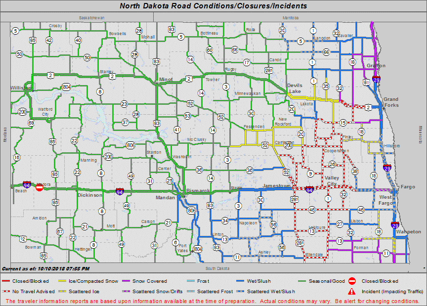
| North Dakota Road Conditions (ND DOT) |
Snow in Badger, MN (Angie Person Gregerson) |
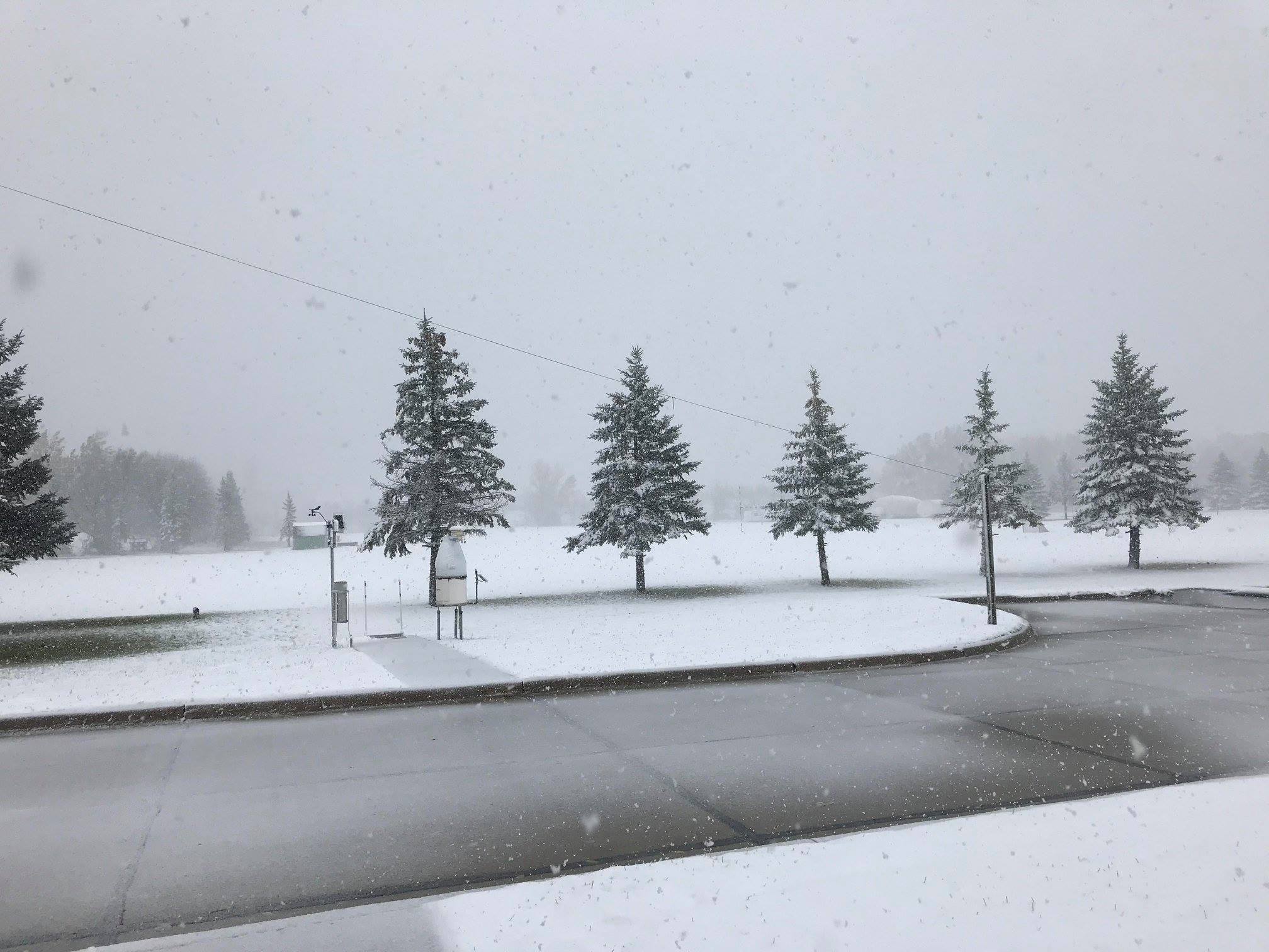
Grand Forks during the Event (NWS Grand Forks) |
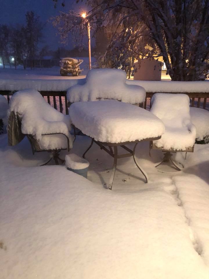
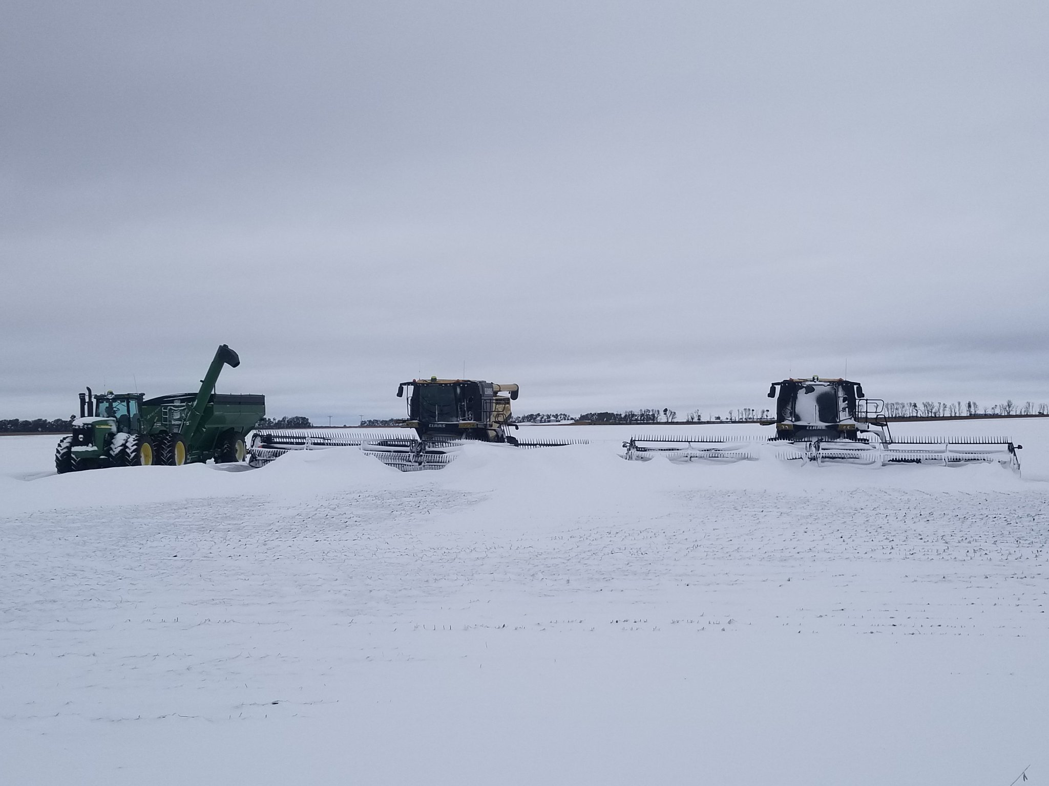
6.5 N Luverne, ND (Brent Johnson) |
Broken tree limbs from heavy snow in Grand Forks, ND (Carl Jones) |
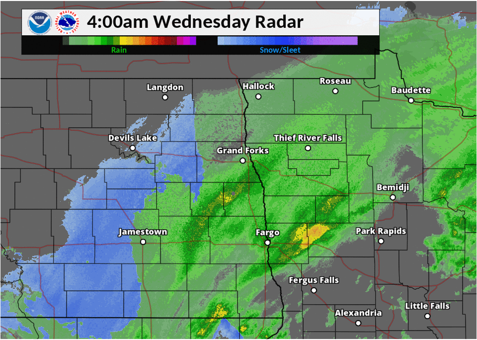
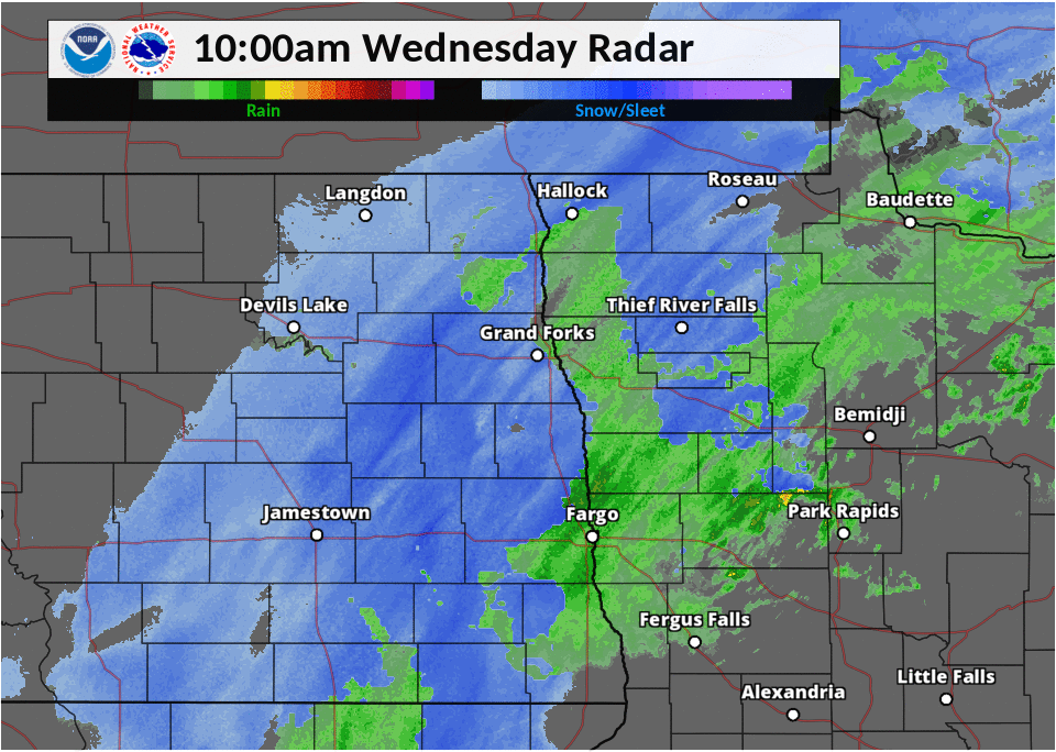
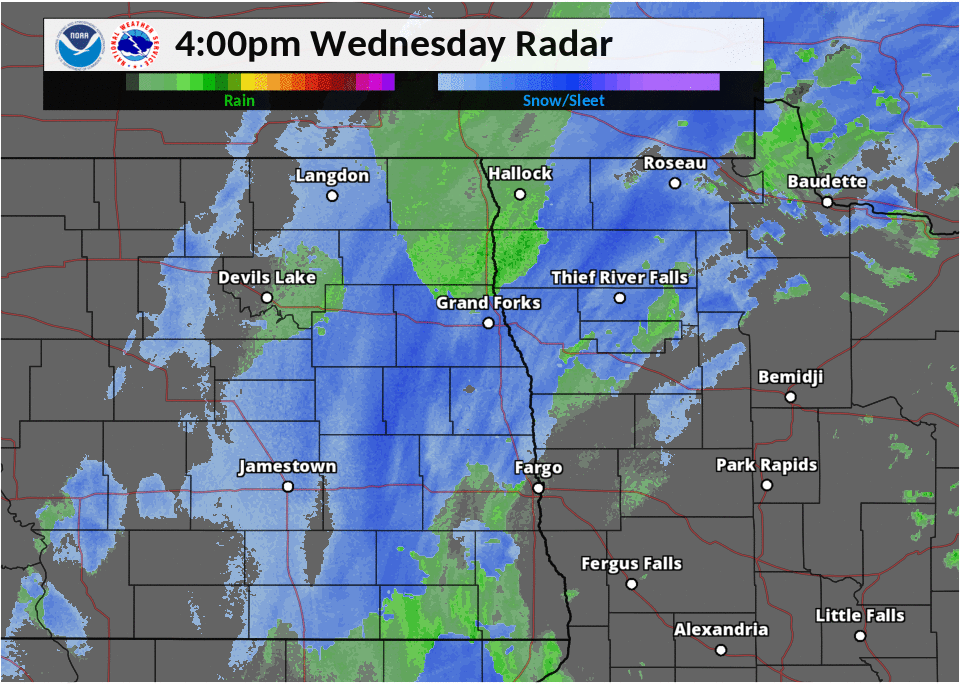
Radar:
Radar Loops from Oct 10 at 4 am to Oct 11 at 4 am
Note the heavy band of snow that extends from Valley City, ND up towards the area to the west of Grand Forks, ND.
 |
 |
 |
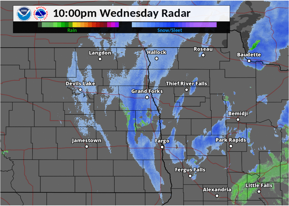 |
| Radar from 4 am to 10 am | Radar from 10 am to 4 pm | Radar from 4 pm to 10 pm | Radar from 10 pm to 4 am |
 |
Media use of NWS Web News Stories is encouraged! Please acknowledge the NWS as the source of any news information accessed from this site. |
|

