
Catastrophic Super Typhoon Bavi's eyewall has reached Rota and is expected to bring dangerous winds, heavy rainfall and storm surge to Guam, Rota, Tinian and Saipan. A Typhoon Warning remains in effect. Heavy to excessive rainfall will continue to bring a flooding threat from coastal Mid-Atlantic to southern New England through Monday. Read More >
Last Map Update: Fri, Jul 10, 2026 at 2:46:24 am MDT
 Briefing |
 Forecast Discussion |
 Weather Hazards Outlook |
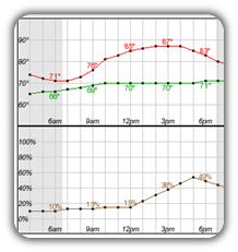 Hourly Forecast |
 Gridded Forecast |
 Weather Calculator |
|
|
 Satellite |
|
 Past Weather |
 Drought |
 Hydrology |
 Wx Radio |
 Skywarn |
 Fire Weather |
Vo1lunteer |
 Aviation |
 Social Media |
 Weather Digest |
 Monsoon/Tropical |


 Radar
Radar Weather Map
 Satellite