Scattered severe thunderstorms capable of damaging wind gusts and some hail are expected this afternoon and evening from the Upper Ohio River Valley into the Northeast, and from the Appalachians into the Mid-Atlantic States. Excessive rainfall from heavy thunderstorms may produce areas of flash flooding from southern New Mexico into the western and northern Gulf Coast into Wednesday. Read More >
Overview
|
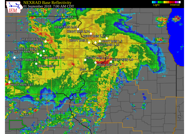
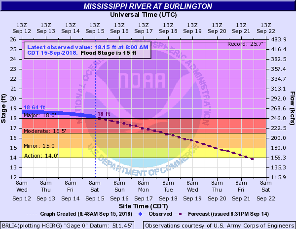
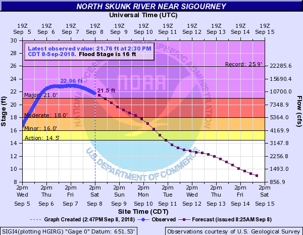
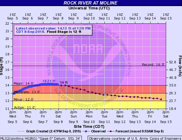
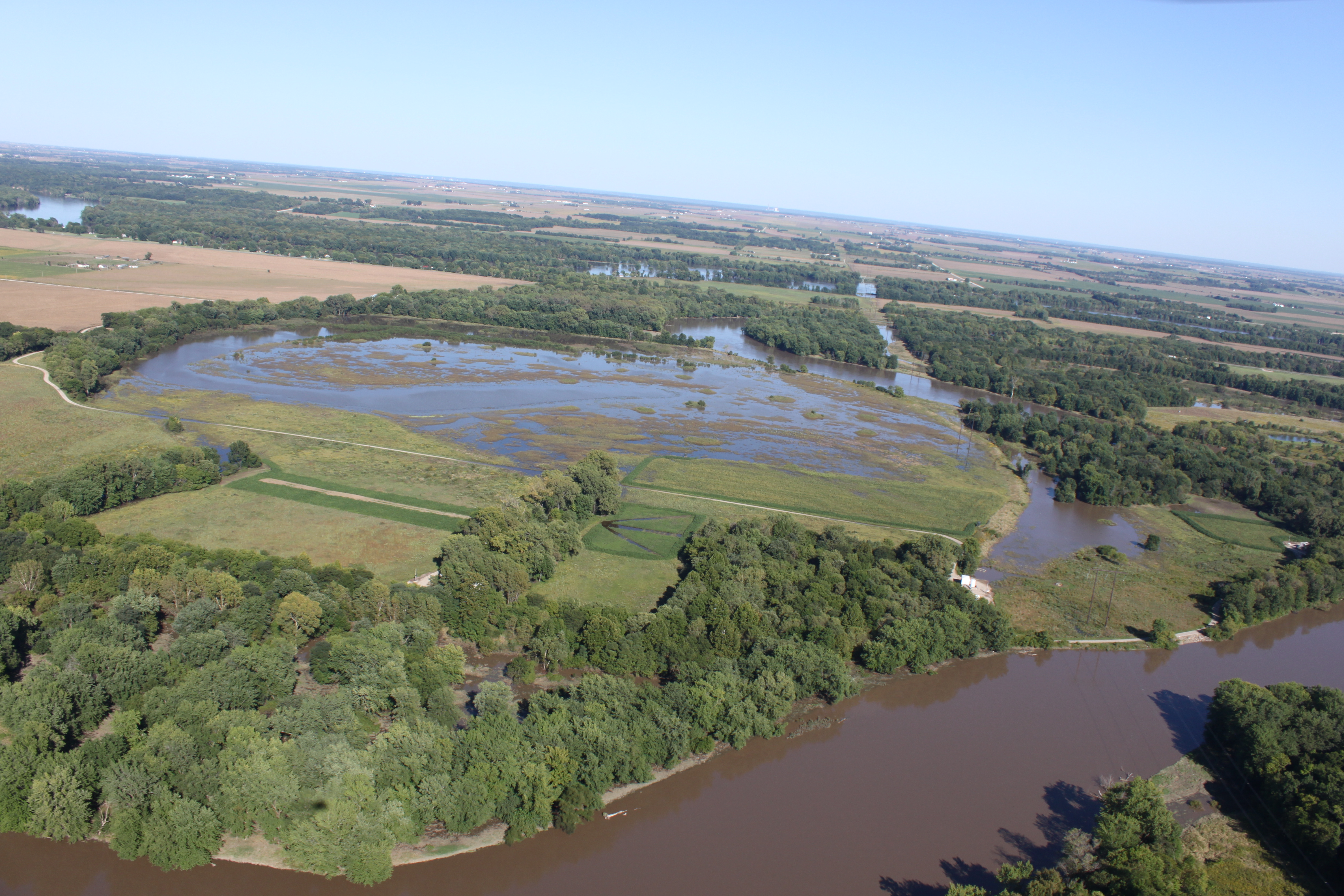
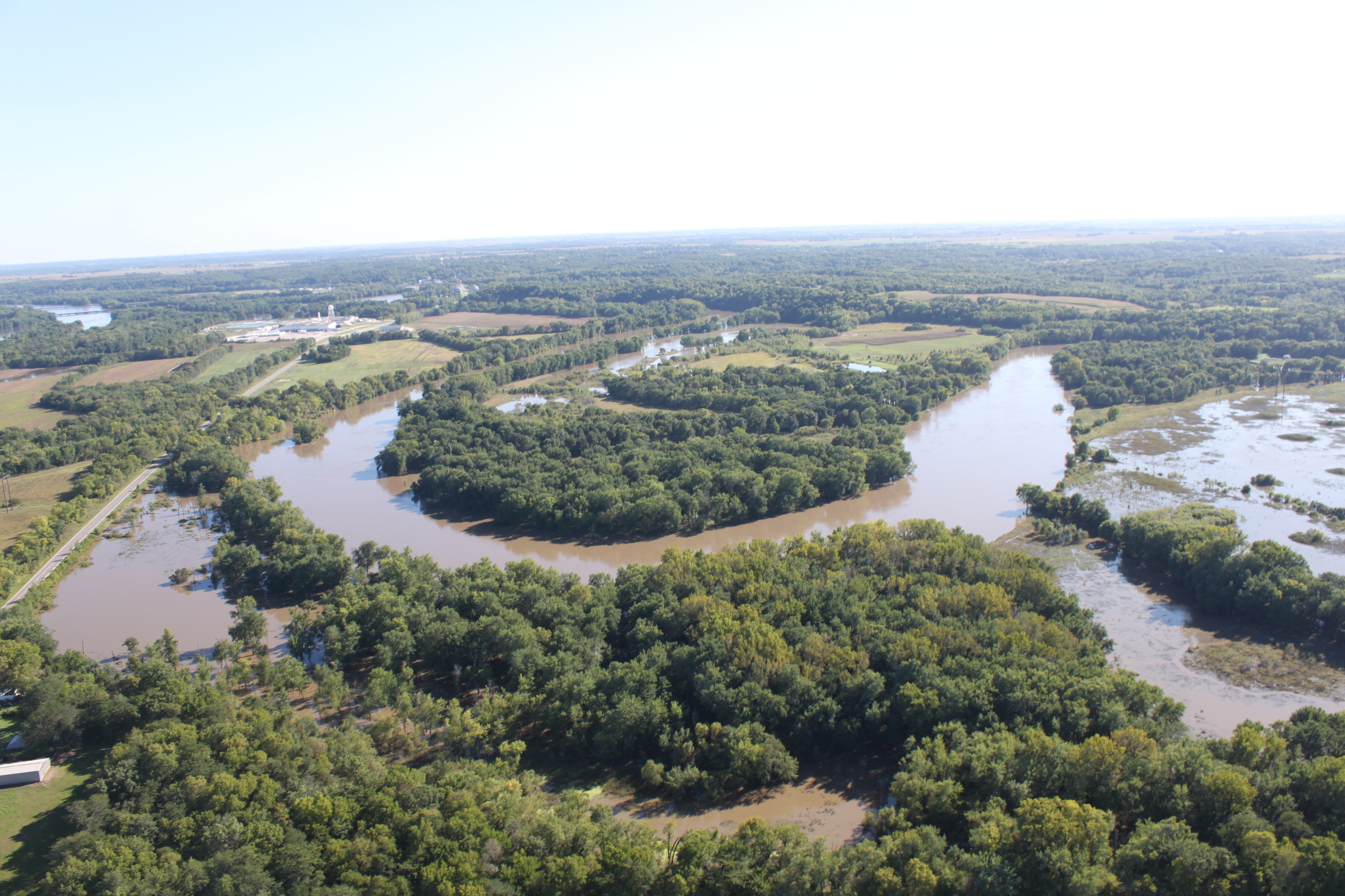
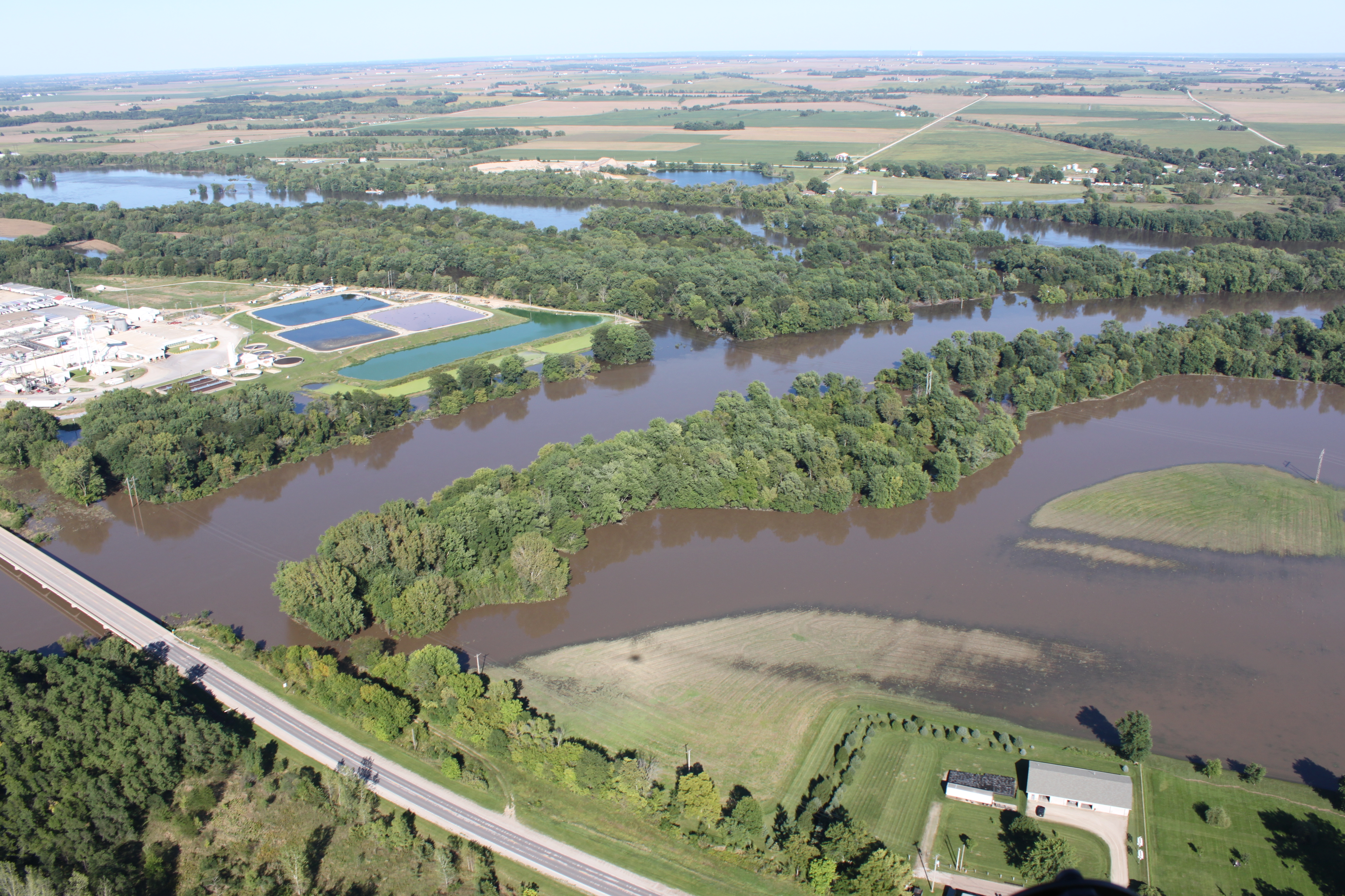
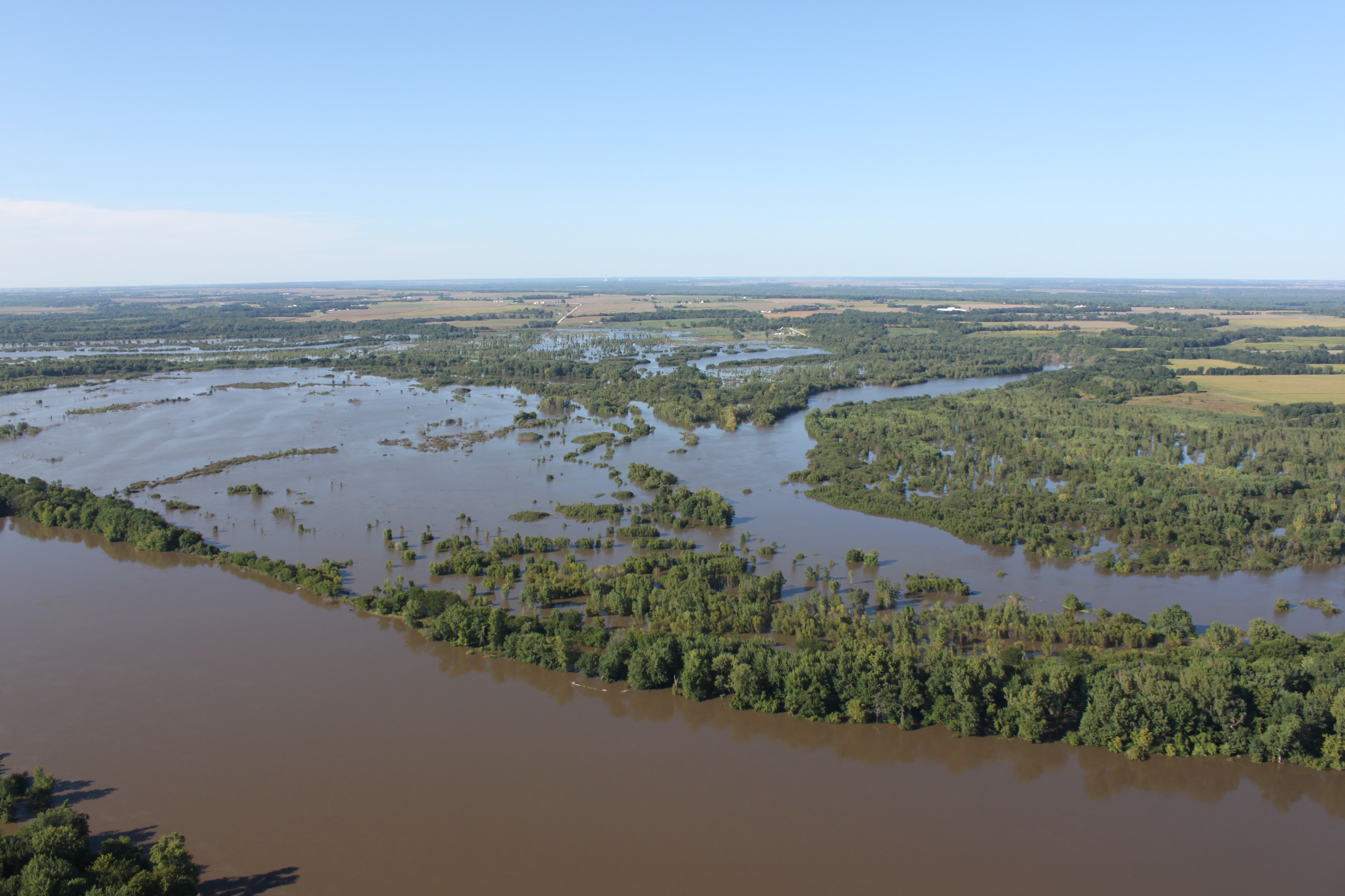
Widespread heavy rain fell from the end of August through early September across the region. Rainfall totals approached 8 inches across portions of eastern IA and northwest IL, with locally heavier amounts due to thunderstorms. This water fell across already saturated soils, and eventually found its way into area rivers and tributaries. This led to significant rises of river levels, and eventually minor to major flooding. The Wapsipinicon, Rock, English, Skunk, Iowa, Cedar, Pecatonica and Mississippi Rivers were all affected. |
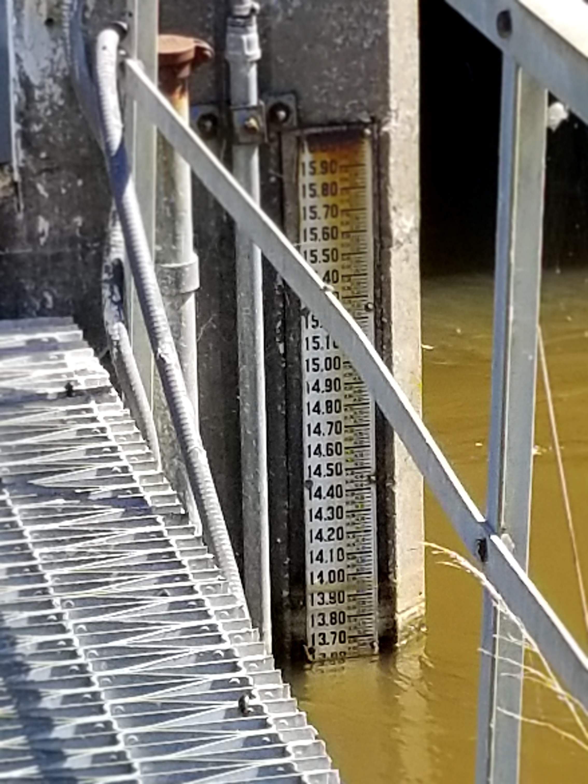
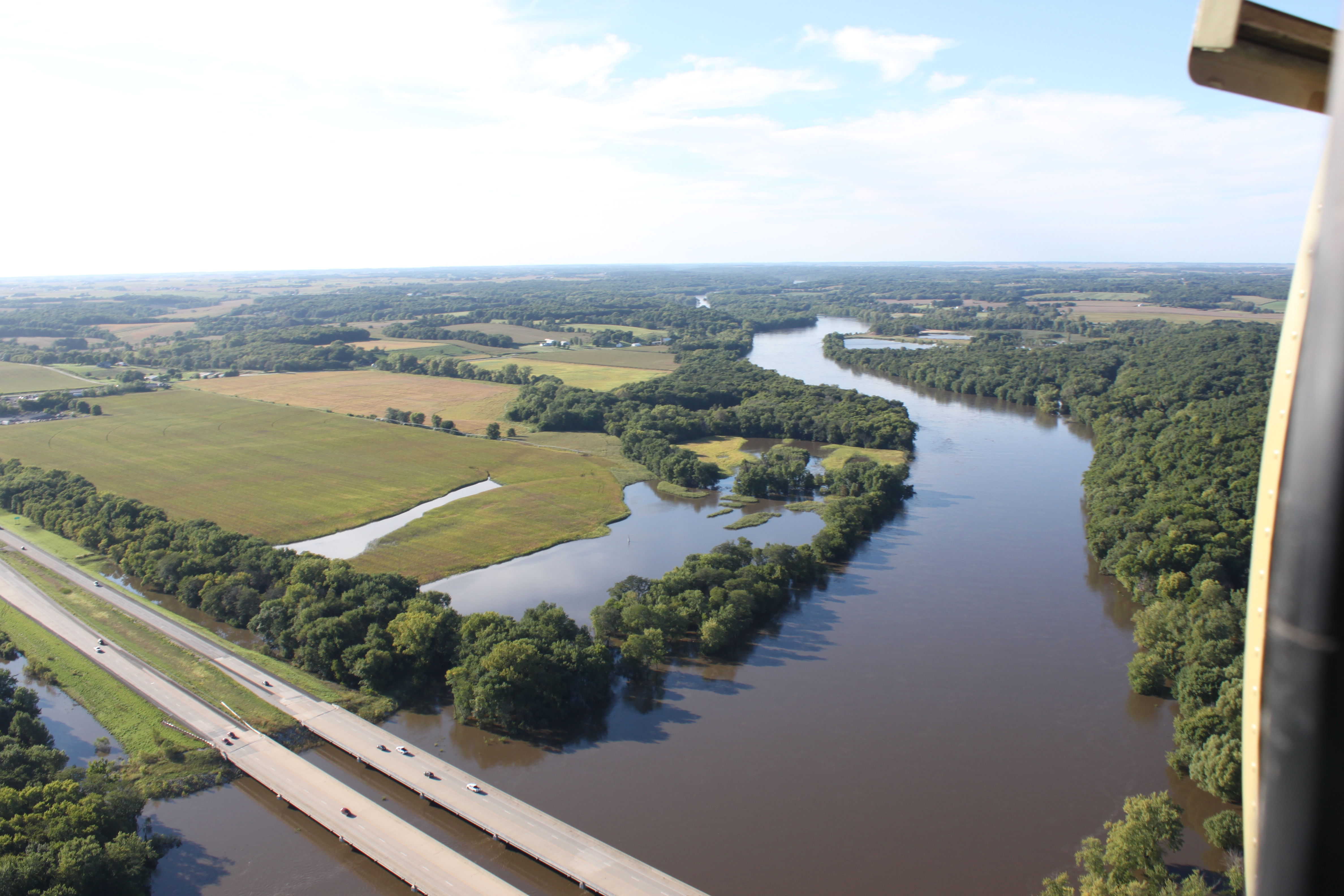 Cedar River at I-80 (Iowa Flood Center Survey) |
Flooding
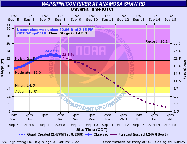
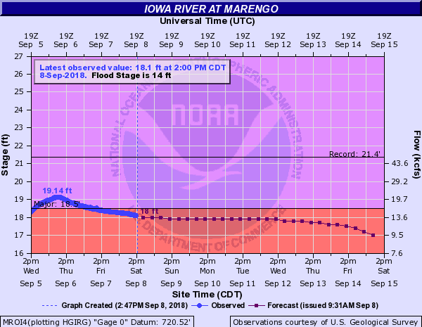
The following rivers experienced flooding in September. The graphs below show the level to which the river crested at each location.
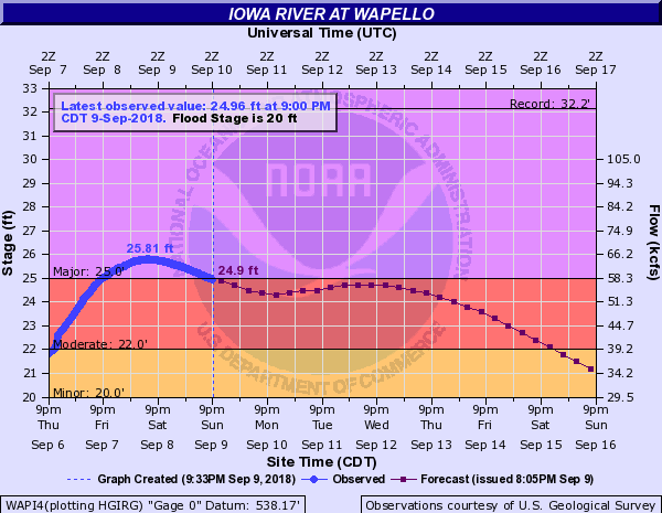
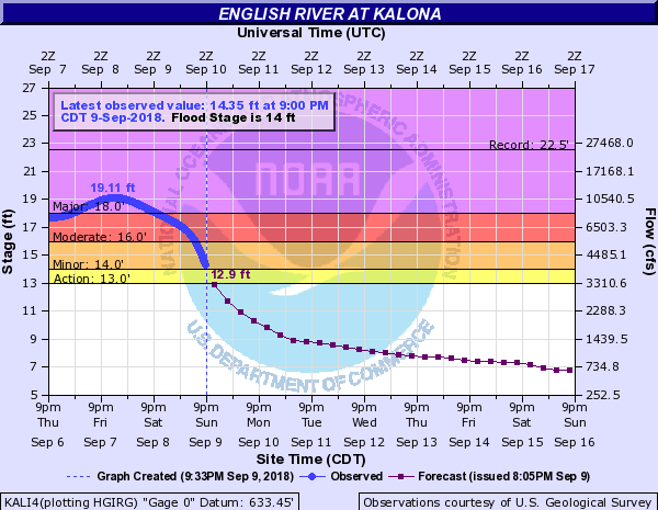
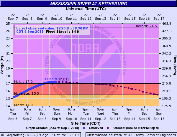
Major Flooding
 |
 |
 |
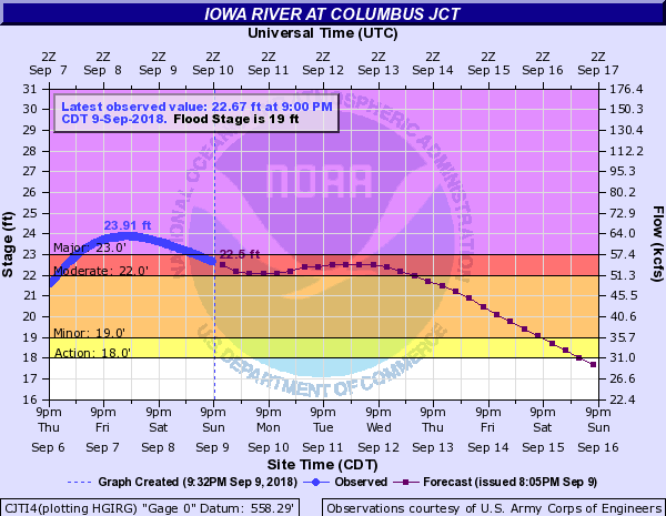 |
| Wapsipinicon River - Anamosa Shaw Rd. | Wapsipinicon River - Dewitt, IA | Iowa River - Marengo, IA | Iowa River - Columbus Junction, IA |
 |
 |
 |
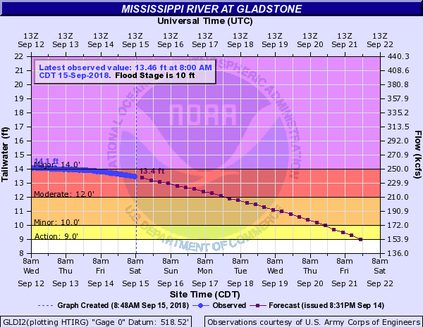 |
| Iowa River - Wapello | English River - Kalona, IA | Mississippi River - Keithsburg, IL | Mississippi River - Gladstone, IL |
 |
 |
 |
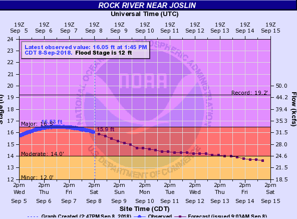 |
| Mississippi River - Burlington, IA | North Skunk River - Sigourney, IA | Rock River - Moline, IL | Rock River - Joslin, IL |
Moderate Flooding
 |
 |
 |
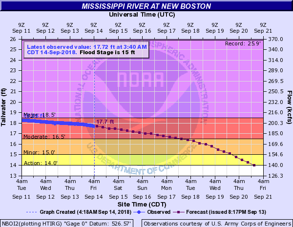 |
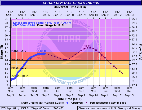
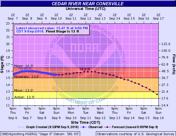
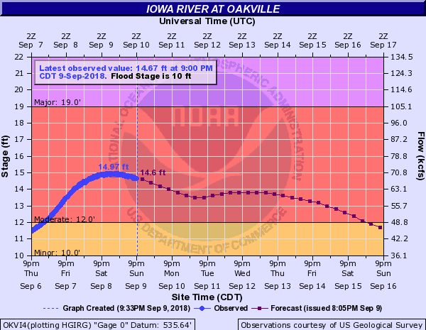
| Cedar River - Cedar Rapids, IA | Cedar River - Conesville, IA | Iowa River - Oakville, IA | Mississippi River - New Boston, IL |
 |
 |
||
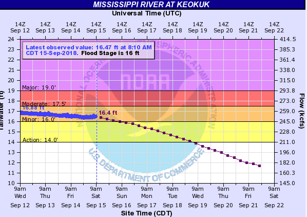
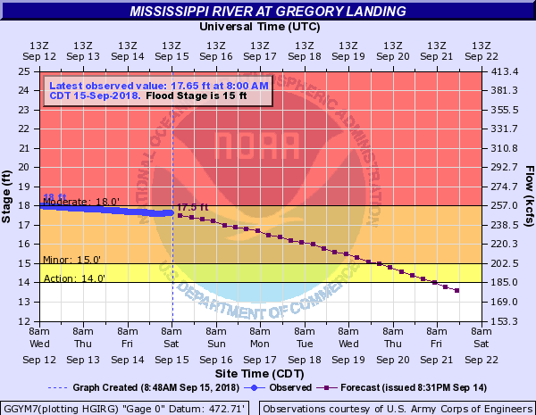
| Mississippi River - Keokuk, IA | Mississippi River - Gregory Landing, MO |
Minor Flooding
 |
 |
 |
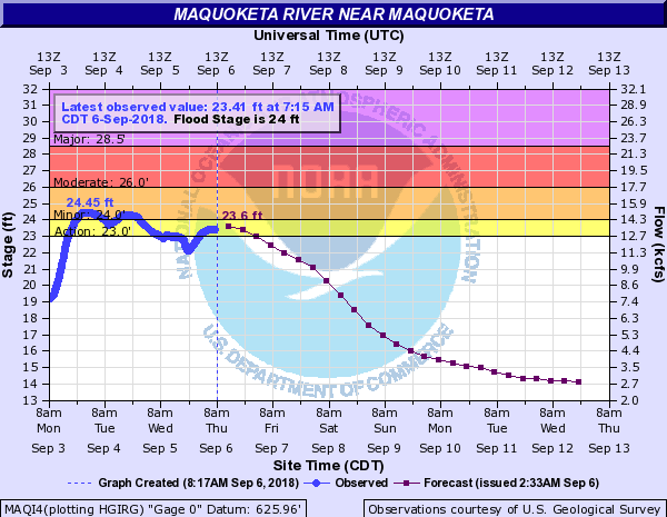 |
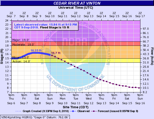
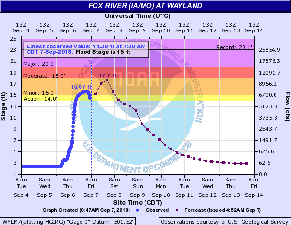
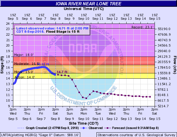
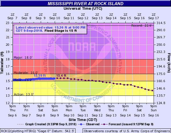
| Cedar River - Vinton, IA | Fox River - Wayland, MO | Iowa River - Lone Tree, IA | Maquoketa River - Maquoketa, IA |
 |
 |
 |
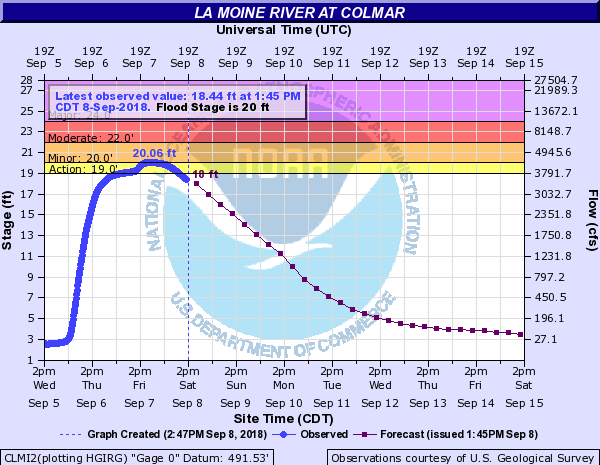 |
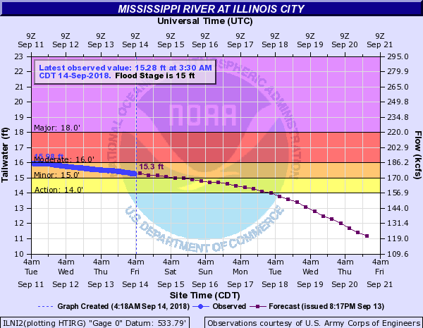
| Mississippi River - Rock Island, IL | Mississippi River - Illinois City, IL | Mississippi River - Muscatine, IA | La Moine River - Colmar, IL |
 |
 |
||
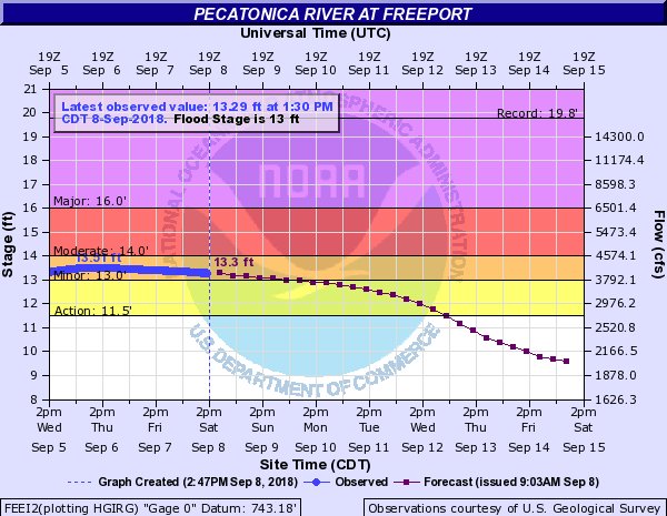
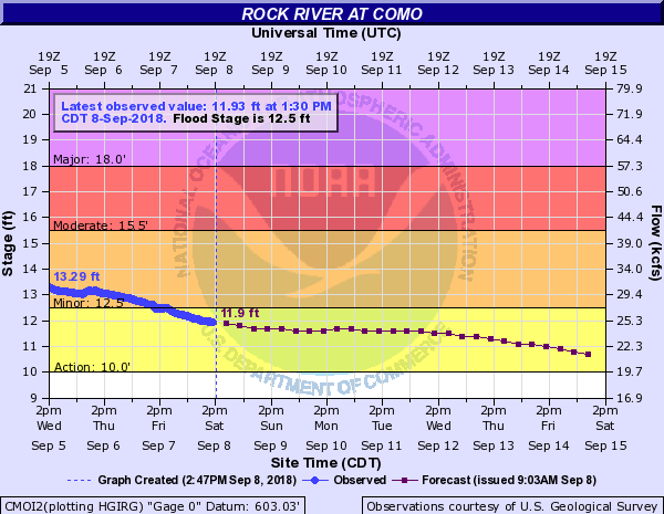
| Pecatonica River - Freeport, IL | Rock River - Como, IL |
Photos:
 |
 |
 |
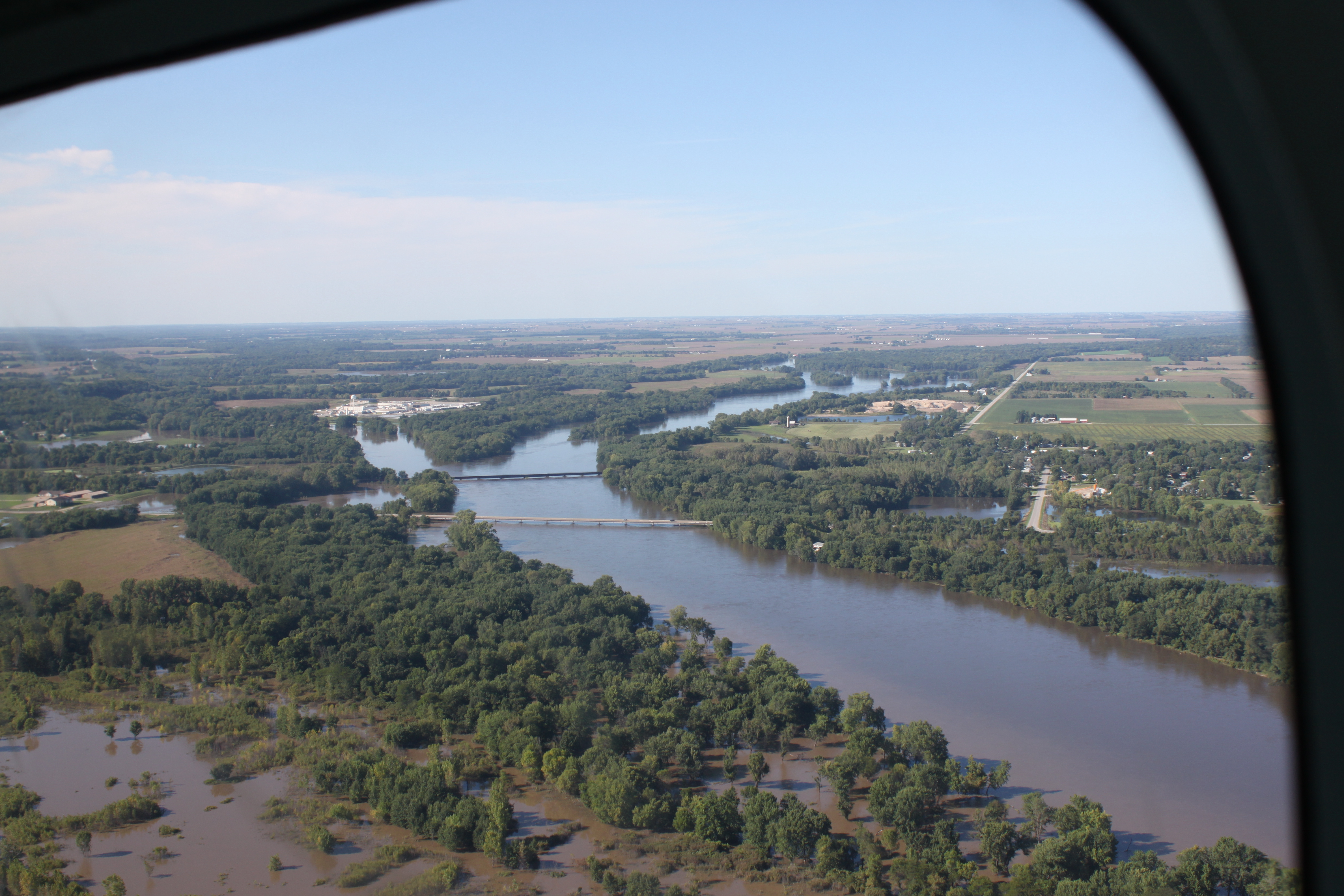 |
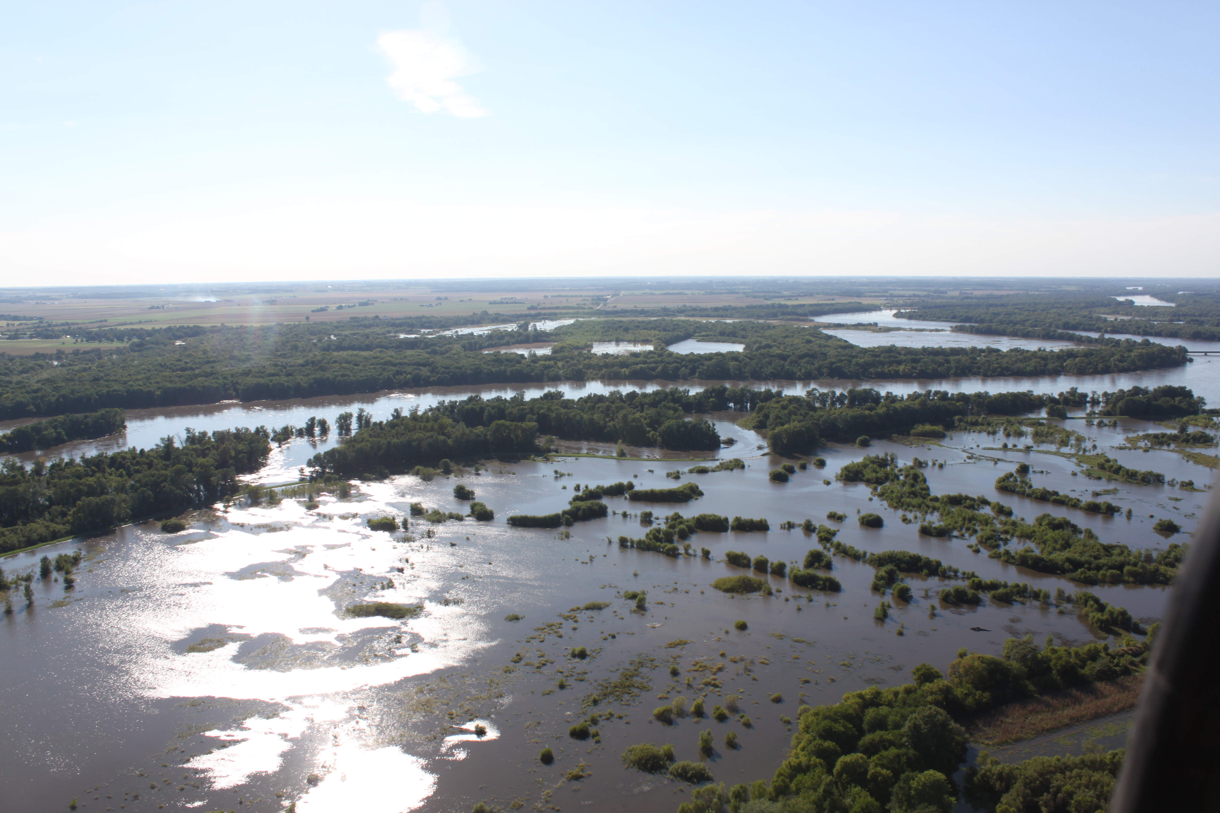
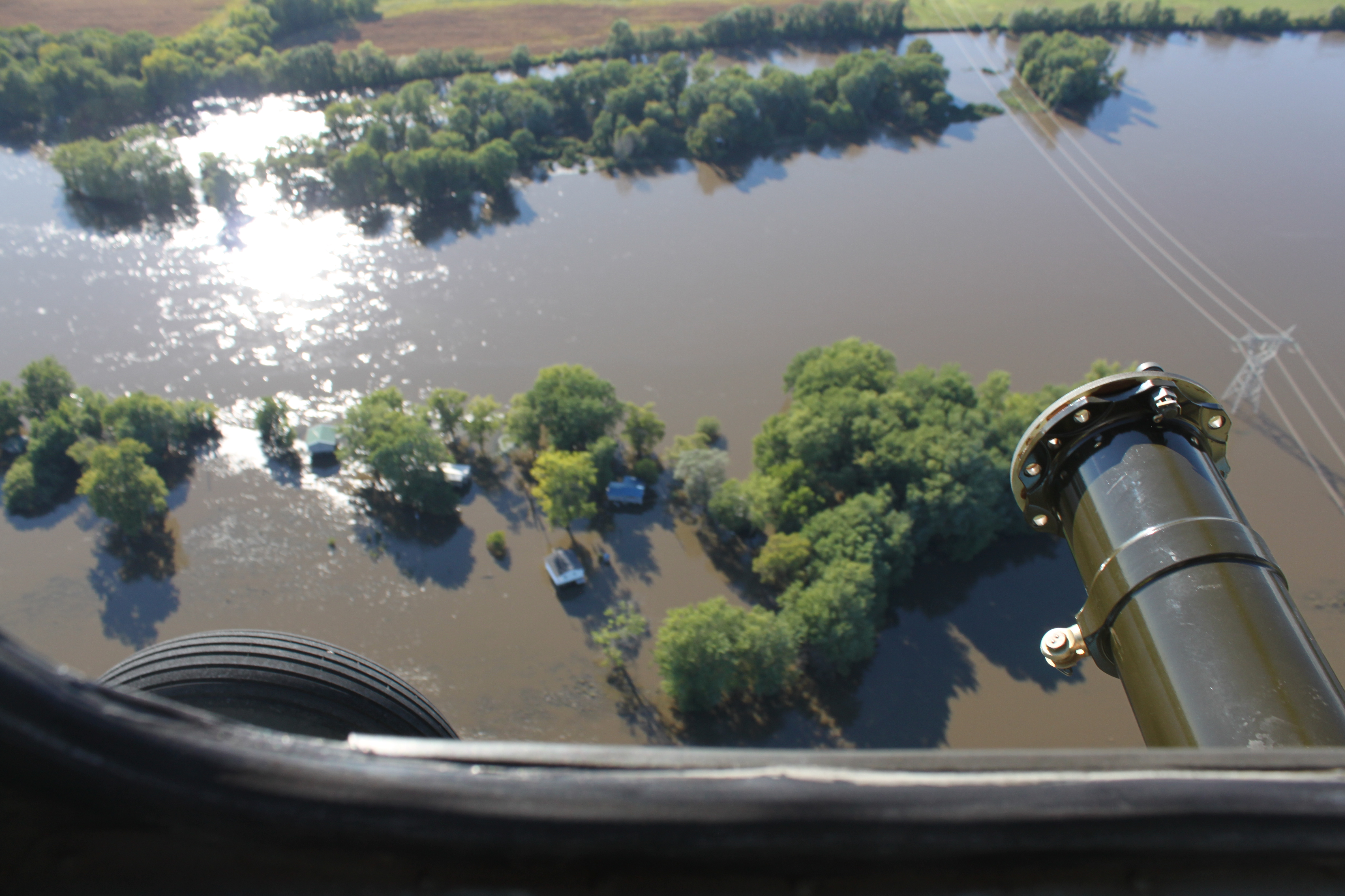
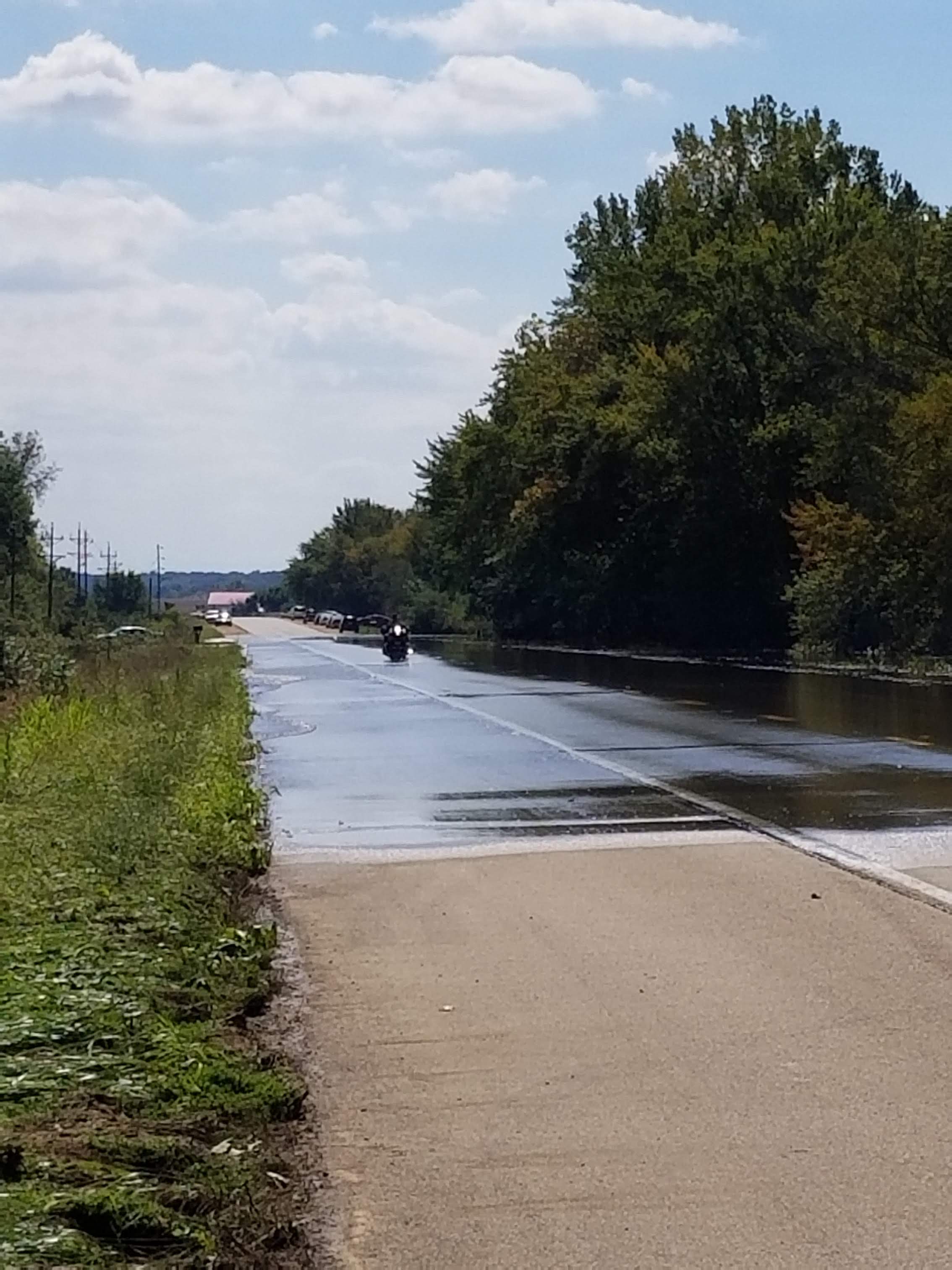
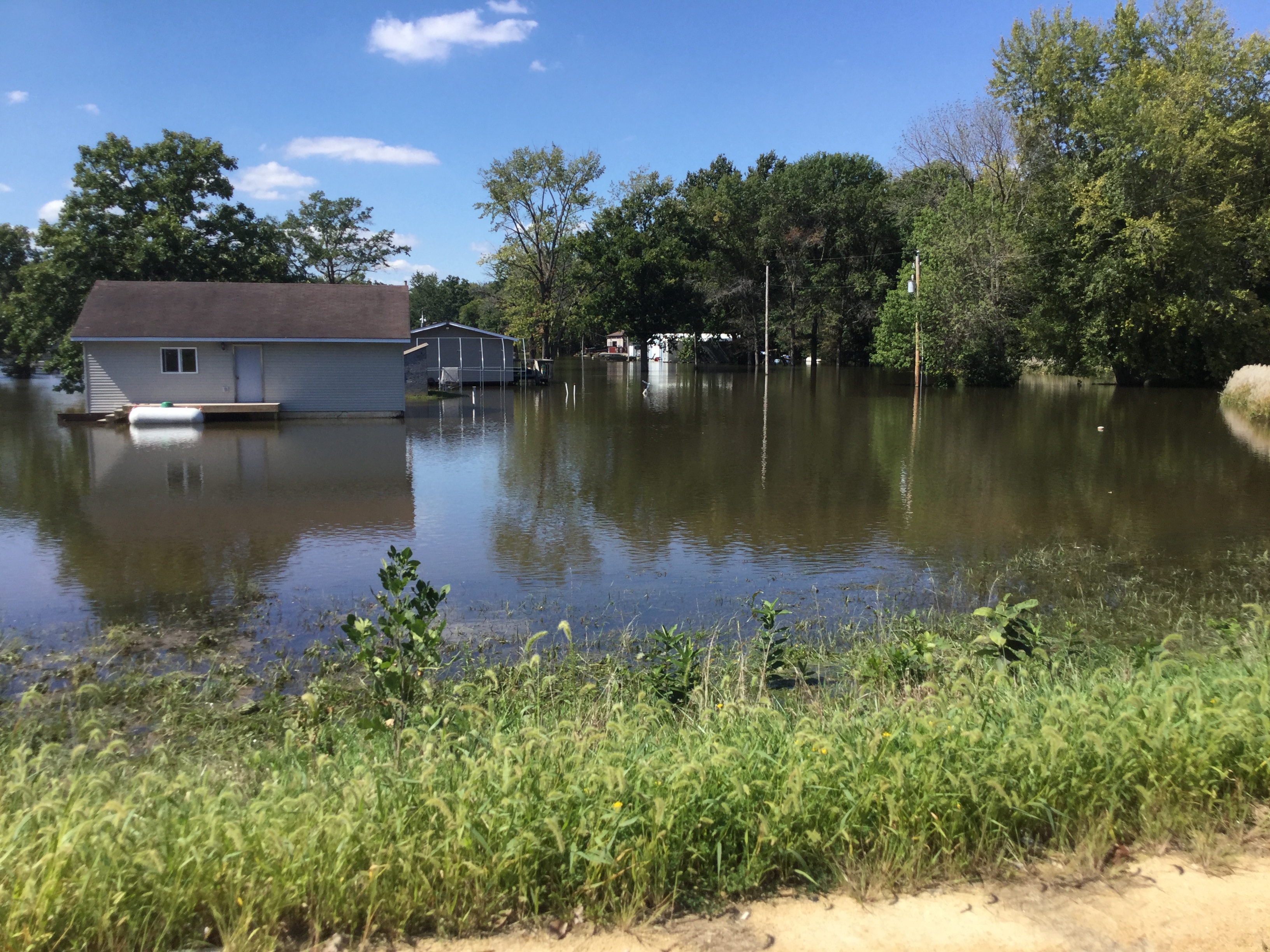
| Flooding Along the Iowa/Cedar Rivers (courtesy Iowa Flood Center Survey) |
Flooding Along the Iowa/Cedar Rivers (courtesy Iowa Flood Center Survey) |
Flooding Along the Iowa/Cedar Rivers (courtesy Iowa Flood Center Survey) |
Flooding Along the Iowa/Cedar Rivers (courtesy Iowa Flood Center Survey) |
 |
 |
 |
 |
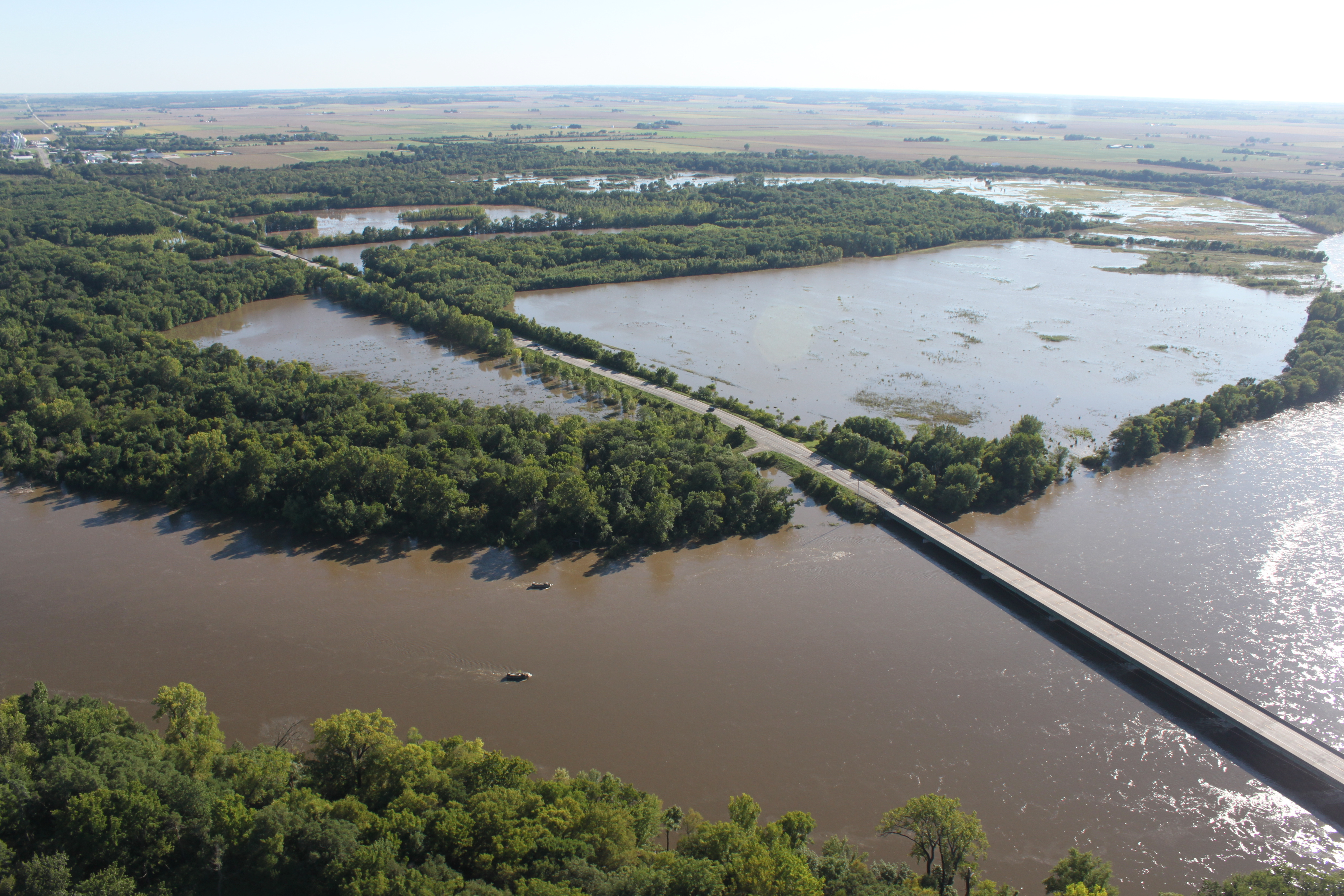
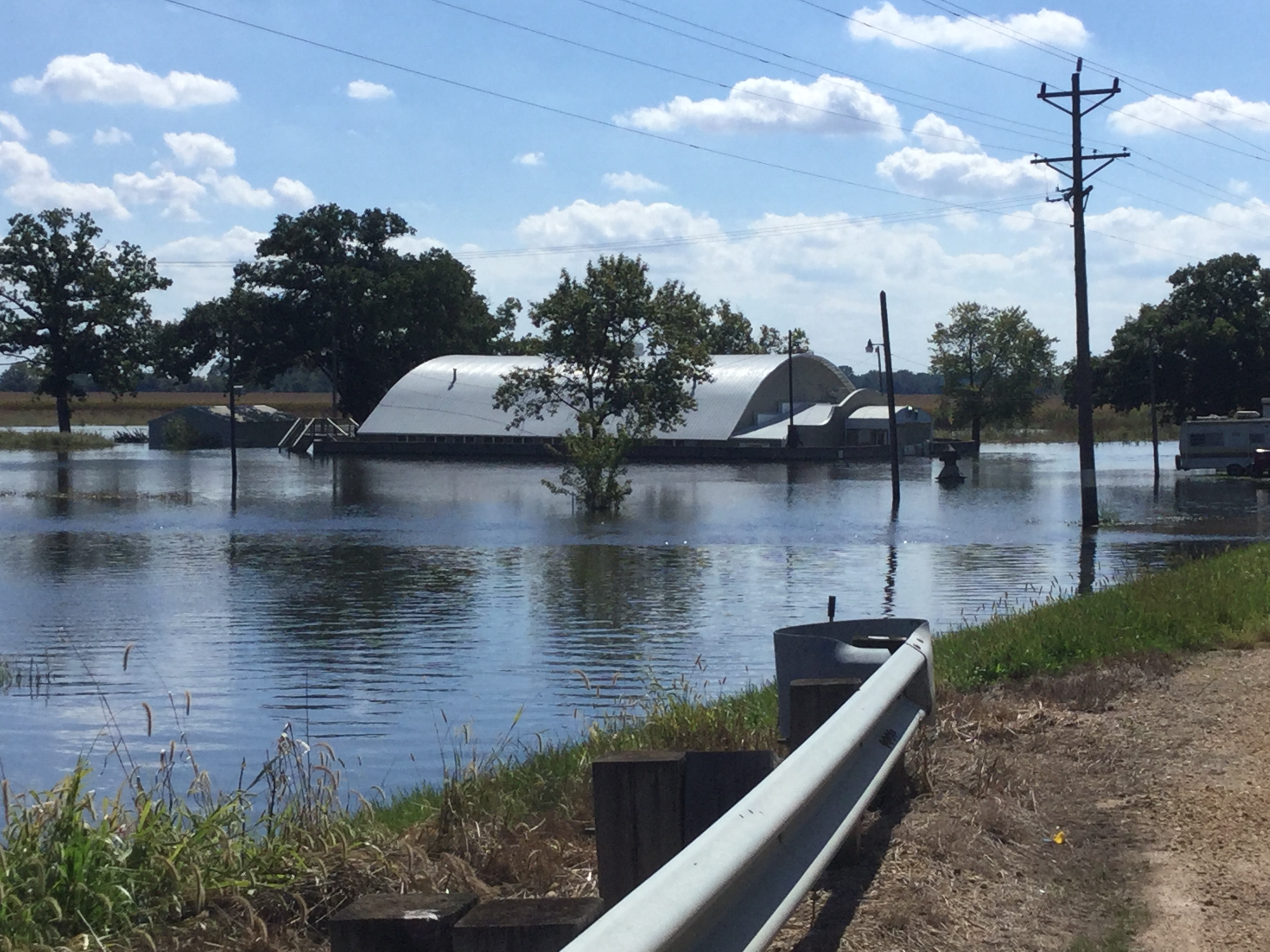
| Flooding Along the Wapsipinicon River near Dewitt, IA (courtesy NWS Flood Survey) |
Flooding Along the Wapsipinicon River near Dewitt, IA (courtesy NWS Flood Survey) |
Flooding Along the Wapsipinicon River near Dewitt, IA (courtesy NWS Flood Survey) |
Flooding Along the Wapsipinicon River near Dewitt, IA (courtesy NWS Flood Survey) |
Storm Reports
| Interactive Storm Report Map |
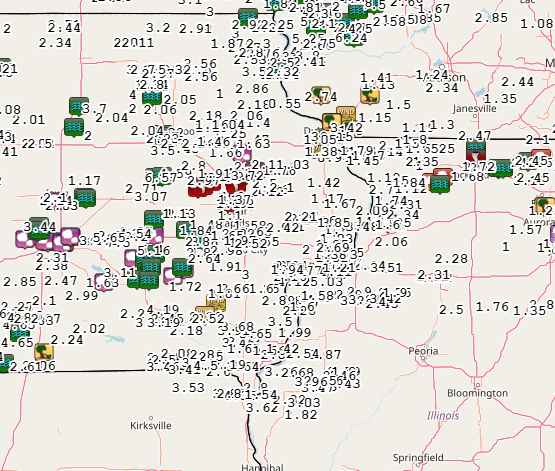 |
PRELIMINARY LOCAL STORM REPORT...SUMMARY
NATIONAL WEATHER SERVICE QUAD CITIES IA IL
904 AM CDT WED AUG 29 2018
..TIME... ...EVENT... ...CITY LOCATION... ...LAT.LON...
..DATE... ....MAG.... ..COUNTY LOCATION..ST.. ...SOURCE....
..REMARKS..
0530 PM TSTM WND DMG WHAT CHEER 41.40N 92.35W
08/28/2018 KEOKUK IA PUBLIC
LARGE TREES DOWN IN WHAT CHEER, TIMES
ESTIMATED BASED ON RADAR.
0540 PM TSTM WND DMG SIGOURNEY 41.33N 92.21W
08/28/2018 KEOKUK IA PUBLIC
REPORT OF TREES DOWN IN SIGOURNEY, TIME
ESTIMATED BASED ON RADAR.
0549 PM TSTM WND DMG 2 NNE NORTH ENGLISH 41.55N 92.06W
08/28/2018 IOWA IA BROADCAST MEDIA
POWER LINES DOWN IN HWY 149 & 310TH STREET,
VIA KWWL.
0552 PM TSTM WND GST 1 ENE PARNELL 41.59N 91.99W
08/28/2018 M60 MPH IOWA IA TRAINED SPOTTER
0558 PM TSTM WND DMG PARNELL 41.58N 92.01W
08/28/2018 IOWA IA TRAINED SPOTTER
NUMEROUS TREES DOWN ALL OVER TOWN. NO POWER
AT RESIDENCE.
0605 PM TSTM WND GST COLUMBUS JUNCTION 41.28N 91.37W
08/28/2018 M60 MPH LOUISA IA TRAINED SPOTTER
DELAYED REPORT.
0610 PM TSTM WND DMG WASHINGTON 41.29N 91.69W
08/28/2018 WASHINGTON IA TRAINED SPOTTER
TREES DOWN IN THE CITY OF WASHINGTON.
0615 PM TSTM WND GST 2 W UNIVERSITY HEIGHTS 41.66N 91.60W
08/28/2018 M82 MPH JOHNSON IA EMERGENCY MNGR
WIND GUST MEASURED AT JOHNSON COUNTY EMA.
TIME ESTIMATED BASED ON RADAR.
0615 PM TSTM WND GST WASHINGTON ARPT 41.28N 91.67W
08/28/2018 M52 MPH WASHINGTON IA AWOS
CORRECTS PREVIOUS NON-TSTM WND GST REPORT
FROM WASHINGTON ARPT. AWOS STATION AWG,
WASHINGTON ARPT.
0615 PM TSTM WND GST FAIRFIELD ARPT 41.05N 91.98W
08/28/2018 M46 MPH JEFFERSON IA AWOS
CORRECTS PREVIOUS NON-TSTM WND GST REPORT
FROM FAIRFIELD ARPT. AWOS STATION FFL,
FAIRFIELD ARPT.
0615 PM TSTM WND GST CEDAR RAPIDS ARPT 41.88N 91.71W
08/28/2018 M47 MPH LINN IA ASOS
CORRECTS PREVIOUS NON-TSTM WND GST REPORT
FROM CEDAR RAPIDS ARPT. ASOS STATION CID,
CEDAR RAPIDS ARPT.
0615 PM TSTM WND GST MOUNT UNION 41.06N 91.39W
08/28/2018 M56 MPH HENRY IA TRAINED SPOTTER
0622 PM TSTM WND DMG IOWA CITY 41.66N 91.53W
08/28/2018 JOHNSON IA EMERGENCY MNGR
POWER LINES AND TREE BRANCHES DOWN IN TOWN
AND SOUTH OF TOWN.
0628 PM TSTM WND GST IOWA CITY ARPT 41.64N 91.55W
08/28/2018 M83 MPH JOHNSON IA ASOS
ASOS STATION IOW, IOWA CITY ARPT.
0630 PM TSTM WND GST 2 SE IOWA CITY 41.64N 91.51W
08/28/2018 M70 MPH JOHNSON IA TRAINED SPOTTER
WINDS MEASURED AT 70 MPH BEFORE THE POWER
WENT OUT. THEY WERE LIKELY HIGHER.
0630 PM TSTM WND DMG 2 SE IOWA CITY 41.64N 91.51W
08/28/2018 JOHNSON IA TRAINED SPOTTER
8 TO 12 INCH DIAMETER HARDWOOD TREE UPROOTED
- WINDS WERE MEASURED AT 70 MPH BEFORE THE
POWER FAILED. THEY WERE LIKELY HIGHER.
0635 PM TSTM WND GST MUSCATINE ARPT 41.37N 91.15W
08/28/2018 M58 MPH MUSCATINE IA AWOS
AWOS STATION MUT, MUSCATINE ARPT.
0654 PM TSTM WND DMG 1 ENE MONTPELIER 41.47N 90.78W
08/28/2018 SCOTT IA TRAINED SPOTTER
10 INCH DIAMETER TREE DOWN ON SOUTH
MISSISSIPPI IN BLUEGRASS.
0654 PM TSTM WND GST 1 ENE MONTPELIER 41.47N 90.78W
08/28/2018 M61 MPH SCOTT IA TRAINED SPOTTER
0708 PM TSTM WND GST DAVENPORT MUNICIPALITY 41.62N 90.58W
08/28/2018 M51 MPH SCOTT IA ASOS
0710 PM TSTM WND DMG PARK VIEW 41.69N 90.54W
08/28/2018 SCOTT IA NWS EMPLOYEE
4 INCH BRANCHES DOWN, ESTIMATED WIND GUST OF
60-65MPH.
0710 PM TSTM WND GST SHERRARD 41.32N 90.51W
08/28/2018 M53 MPH MERCER IL ASOS
MEASURED AT I-74 RWIS.
0712 PM TSTM WND DMG 2 E DAVENPORT 41.54N 90.53W
08/28/2018 SCOTT IA NWS EMPLOYEE
NUMEROUS 3 TO 5 INCH DIAMETER BRANCHES DOWN
BETWEEN HWY 74 AND BRIDGE AVE ON LOCUST
STREET. TIME ESTIMATED FROM RADAR.
0713 PM TSTM WND GST 4 SSE MAYSVILLE 41.60N 90.68W
08/28/2018 M59 MPH SCOTT IA ASOS
MEASURED AT THE I80-I280 RWIS.
0725 PM TSTM WND GST 1 NNW BUFFALO 41.47N 90.73W
08/28/2018 E38 MPH SCOTT IA TRAINED SPOTTER
0727 PM TSTM WND DMG BUFFALO 41.47N 90.78W
08/28/2018 SCOTT IA TRAINED SPOTTER
1 MILE EAST OF HACKER ST TREE ON A HOUSE.
0742 PM TSTM WND GST 1 WNW DEWITT 41.83N 90.57W
08/28/2018 E59 MPH CLINTON IA ASOS
MEASURED AT THE DEWITT RWIS.
0747 PM TSTM WND GST CLINTON MUNICIPALITY 41.83N 90.33W
08/28/2018 M61 MPH CLINTON IA AWOS
0750 PM TSTM WND DMG 1 NNW MOUNT CARROLL 42.10N 89.98W
08/28/2018 CARROLL IL TRAINED SPOTTER
NUMEROUS TREE LIMBS AND SMALL TREES DOWN IN
MOUNT CARROLL, ONE TREE ON A HOUSE. TIME
ESTIMATED BASED ON RADAR.
0810 PM TSTM WND GST FREEPORT 42.28N 89.63W
08/28/2018 M48 MPH STEPHENSON IL TRAINED SPOTTER
0830 PM TSTM WND GST 1 NNW KAHOKA 40.43N 91.72W
08/28/2018 M60 MPH CLARK MO TRAINED SPOTTER
MOSTLY WINDS AROUND 40 MPH BUT HAD BRIEF
GUSTS TO 60 MPH.
0830 PM TSTM WND DMG MOUNT PLEASANT 40.96N 91.55W
08/28/2018 HENRY IA EMERGENCY MNGR
REPORT OF POWER LINES DOWN IN THE CITY OF
MOUNT PLEASANT FROM EMERGENCY MANAGEMENT.
0845 PM TSTM WND DMG KEOKUK 40.40N 91.39W
08/28/2018 LEE IA TRAINED SPOTTER
MULTIPLE TREES DOWN IN KEOKUK, ONE AROUND 7
INCHES IN DIAMETER ON ROAD. TREES DOWN ALSO
IN HAMILTON, IL ACROSS THE RIVER. TIME
ESTIMATED FROM RADAR.
0900 PM TSTM WND GST CARTHAGE 40.41N 91.14W
08/28/2018 M60 MPH HANCOCK IL TRAINED SPOTTER
0927 PM TSTM WND DMG ALEDO 41.20N 90.75W
08/28/2018 MERCER IL LAW ENFORCEMENT
TREE DOWN IN ALEDO, REPORTED BY ELECTRIC
COMPANY TO SHERIFF'S OFFICE.
0930 PM TSTM WND DMG 3 E COLMAR 40.35N 90.83W
08/28/2018 MCDONOUGH IL TRAINED SPOTTER
TREE AND POWER LINE DOWN.
0950 PM HEAVY RAIN 2 WSW YARMOUTH 41.02N 91.35W
08/28/2018 M5.10 INCH DES MOINES IA TRAINED SPOTTER
1010 PM HEAVY RAIN 2 SW NEW LONDON 40.91N 91.43W
08/28/2018 M2.07 INCH HENRY IA TRAINED SPOTTER
RAINFALL FROM 7:50-8:40 PM. IT IS STILL
RAINING.
1017 PM HEAVY RAIN MOUNT PLEASANT 40.96N 91.54W
08/28/2018 M3.00 INCH HENRY IA TRAINED SPOTTER
RAINFALL TOTAL FOR THE DAY AS OF 1015 PM.
1140 PM HEAVY RAIN CANTRIL 40.64N 92.07W
08/28/2018 M3.40 INCH VAN BUREN IA TRAINED SPOTTER
STORM TOTAL PAST 12 HOURS.
0500 AM HEAVY RAIN 1 NW GENESEO 41.47N 90.18W
08/29/2018 M2.94 INCH HENRY IL COCORAHS
COCORAHS STATION IL-HY-8, 1 NW GENESEO.
0530 AM HEAVY RAIN 1 NW DAVENPORT 41.56N 90.61W
08/29/2018 M2.36 INCH SCOTT IA TRAINED SPOTTER
STORM TOTAL PAST 24 HOURS.
0600 AM HEAVY RAIN MEMPHIS 40.46N 92.17W
08/29/2018 M3.98 INCH SCOTLAND MO CO-OP OBSERVER
CO-OP OBSERVER STATION MMPM7, MEMPHIS.
0600 AM HEAVY RAIN NEW BOSTON L/D 17 41.18N 91.05W
08/29/2018 M4.80 INCH MERCER IL MESONET
MESONET STATION NBOI2, NEW BOSTON L/D 17.
0600 AM HEAVY RAIN 5 NE BRIGHTON 41.24N 91.77W
08/29/2018 M2.85 INCH WASHINGTON IA COCORAHS
COCORAHS STATION IA-WS-8, 5 NE BRIGHTON.
0600 AM HEAVY RAIN COYNE CENTER 41.40N 90.56W
08/29/2018 M4.50 INCH ROCK ISLAND IL COCORAHS
COCORAHS STATION IL-RI-21, COYNE CENTER.
0600 AM HEAVY RAIN 2 W KEWANEE MUNICIPAL 41.20N 90.00W
08/29/2018 M2.50 INCH HENRY IL COCORAHS
COCORAHS STATION IL-HY-13, 2 W KEWANEE
MUNICIPAL.
0600 AM HEAVY RAIN 2 NE COLUSA 40.60N 91.14W
08/29/2018 M2.33 INCH HANCOCK IL TRAINED SPOTTER
24-HR TOTAL, 50+ MPH WIND ALSO SEEN LAST
NIGHT.
0600 AM HEAVY RAIN 2 S PRAIRIE CITY 40.59N 90.46W
08/29/2018 M2.59 INCH MCDONOUGH IL CO-OP OBSERVER
CO-OP OBSERVER STATION PRCI2, 2 S PRAIRIE
CITY.
0620 AM HEAVY RAIN 3 E SALEM 40.84N 91.56W
08/29/2018 M2.72 INCH HENRY IA COCORAHS
COCORAHS STATION IA-HY-5, 3 E SALEM.
0620 AM HEAVY RAIN 1 ESE NEW LONDON 40.92N 91.40W
08/29/2018 M3.80 INCH HENRY IA TRAINED SPOTTER
STORM TOTAL PAST 24 HOURS.
0629 AM HEAVY RAIN BUSHNELL 40.56N 90.51W
08/29/2018 M2.94 INCH MCDONOUGH IL TRAINED SPOTTER
RAINFALL TOTAL FROM 915 PM - 615 AM THIS
MORNING.
0630 AM HEAVY RAIN RIVERDALE 41.54N 90.45W
08/29/2018 M2.68 INCH SCOTT IA COCORAHS
COCORAHS STATION IA-ST-8, RIVERDALE.
0652 AM HEAVY RAIN DAVENPORT ARPT 41.61N 90.59W
08/29/2018 M2.14 INCH SCOTT IA ASOS
ASOS STATION DVN, DAVENPORT ARPT.
0652 AM HEAVY RAIN IOWA CITY ARPT 41.64N 91.55W
08/29/2018 M2.40 INCH JOHNSON IA ASOS
ASOS STATION IOW, IOWA CITY ARPT.
0655 AM HEAVY RAIN WASHINGTON ARPT 41.28N 91.67W
08/29/2018 M2.39 INCH WASHINGTON IA AWOS
AWOS STATION AWG, WASHINGTON ARPT.
0655 AM HEAVY RAIN MACOMB ARPT 40.52N 90.65W
08/29/2018 M2.24 INCH MCDONOUGH IL AWOS
AWOS STATION MQB, MACOMB ARPT.
0655 AM HEAVY RAIN FAIRFIELD ARPT 41.05N 91.98W
08/29/2018 M3.14 INCH JEFFERSON IA AWOS
AWOS STATION FFL, FAIRFIELD ARPT.
0655 AM HEAVY RAIN KEOKUK ARPT 40.46N 91.43W
08/29/2018 M2.80 INCH LEE IA AWOS
AWOS STATION EOK, KEOKUK ARPT.
0656 AM HEAVY RAIN CLINTON ARPT 41.83N 90.33W
08/29/2018 M2.14 INCH CLINTON IA AWOS
AWOS STATION CWI, CLINTON ARPT.
0659 AM HEAVY RAIN QUAD CITY INTL ARPT 41.45N 90.51W
08/29/2018 M3.64 INCH ROCK ISLAND IL ASOS
ASOS STATION MLI, QUAD CITY INTL ARPT.
0700 AM HEAVY RAIN IOWA CITY 41.65N 91.53W
08/29/2018 M2.43 INCH JOHNSON IA CO-OP OBSERVER
CO-OP OBSERVER STATION ICYI4, IOWA CITY.
0700 AM HEAVY RAIN CAMANCHE 1.2 W 41.80N 90.28W
08/29/2018 M2.64 INCH CLINTON IA COCORAHS
COCORAHS STATION IA-CN-5, CAMANCHE 1.2 W.
0700 AM HEAVY RAIN 2 NNE NEW WINDSOR 41.23N 90.44W
08/29/2018 M2.89 INCH HENRY IL COCORAHS
COCORAHS STATION IL-HY-6, 2 NNE NEW WINDSOR.
0700 AM HEAVY RAIN 2 ENE ARGYLE LAKE STATE 40.46N 90.75W
08/29/2018 M2.46 INCH MCDONOUGH IL COCORAHS
COCORAHS STATION IL-MCD-7, 2 ENE ARGYLE LAKE
STATE.
0700 AM HEAVY RAIN ALEDO 41.22N 90.75W
08/29/2018 M4.16 INCH MERCER IL CO-OP OBSERVER
CO-OP OBSERVER STATION ALEI2, ALEDO.
0700 AM HEAVY RAIN SHANNON 42.15N 89.74W
08/29/2018 M2.21 INCH CARROLL IL COCORAHS
COCORAHS STATION IL-CR-13, SHANNON.
0700 AM HEAVY RAIN 3 NW ELIZA 41.34N 91.01W
08/29/2018 M4.12 INCH ROCK ISLAND IL COCORAHS
COCORAHS STATION IL-RI-22, 3 NW ELIZA.
0700 AM HEAVY RAIN 1 N MUSCATINE 41.44N 91.07W
08/29/2018 M2.50 INCH MUSCATINE IA COCORAHS
COCORAHS STATION IA-MC-10, 1 N MUSCATINE.
0700 AM HEAVY RAIN RIVERDALE 41.54N 90.47W
08/29/2018 M2.79 INCH SCOTT IA COCORAHS
COCORAHS STATION IA-ST-42, RIVERDALE.
0700 AM HEAVY RAIN 1 E KEWANEE 41.25N 89.90W
08/29/2018 M2.75 INCH HENRY IL CO-OP OBSERVER
CO-OP OBSERVER STATION KEWI2, 1 E KEWANEE.
0700 AM HEAVY RAIN PRINCETON 41.38N 89.48W
08/29/2018 M2.52 INCH BUREAU IL CO-OP OBSERVER
CO-OP OBSERVER STATION PTNI2, PRINCETON.
0700 AM HEAVY RAIN PROPHETSTOWN 41.67N 89.94W
08/29/2018 M2.08 INCH WHITESIDE IL COCORAHS
COCORAHS STATION IL-WD-18, PROPHETSTOWN.
0700 AM HEAVY RAIN SALEM 1 S 40.83N 91.62W
08/29/2018 M3.46 INCH HENRY IA CO-OP OBSERVER
CO-OP OBSERVER STATION SLHI4, SALEM 1 S.
0700 AM HEAVY RAIN DONNELLSON 40.63N 91.57W
08/29/2018 M2.27 INCH LEE IA CO-OP OBSERVER
CO-OP OBSERVER STATION DNNI4, DONNELLSON.
0700 AM HEAVY RAIN WASHINGTON 41.28N 91.68W
08/29/2018 M2.90 INCH WASHINGTON IA CO-OP OBSERVER
CO-OP OBSERVER STATION WSHI4, WASHINGTON.
0700 AM HEAVY RAIN 2 S ANDOVER 41.26N 90.29W
08/29/2018 M2.90 INCH HENRY IL COCORAHS
COCORAHS STATION IL-HY-16, 2 S ANDOVER.
0700 AM HEAVY RAIN MOUNT PLEASANT 40.95N 91.55W
08/29/2018 M6.10 INCH HENRY IA CO-OP OBSERVER
CO-OP OBSERVER STATION MPZI4, MOUNT
PLEASANT.
0700 AM HEAVY RAIN NWS DAVENPORT 41.61N 90.58W
08/29/2018 M2.13 INCH SCOTT IA CO-OP OBSERVER
CO-OP OBSERVER STATION DVNI4, NWS DAVENPORT.
0700 AM HEAVY RAIN MACOMB 40.47N 90.67W
08/29/2018 M3.10 INCH MCDONOUGH IL CO-OP OBSERVER
CO-OP OBSERVER STATION MQBI2, MACOMB.
0700 AM HEAVY RAIN LA HARPE 40.58N 90.97W
08/29/2018 M2.30 INCH HANCOCK IL CO-OP OBSERVER
CO-OP OBSERVER STATION LAHI2, LA HARPE.
0700 AM HEAVY RAIN SUTTER 40.29N 91.36W
08/29/2018 M3.62 INCH HANCOCK IL COCORAHS
COCORAHS STATION IL-HN-2, SUTTER.
0700 AM HEAVY RAIN 2 ENE CALAMUS 41.84N 90.73W
08/29/2018 M2.36 INCH CLINTON IA COCORAHS
COCORAHS STATION IA-CN-2, 2 ENE CALAMUS.
0700 AM HEAVY RAIN PARK VIEW 41.69N 90.54W
08/29/2018 M2.00 INCH SCOTT IA COCORAHS
COCORAHS STATION IA-ST-3, PARK VIEW.
0700 AM HEAVY RAIN 2 WSW CHADWICK 42.00N 89.94W
08/29/2018 M2.02 INCH CARROLL IL COCORAHS
COCORAHS STATION IL-CR-4, 2 WSW CHADWICK.
0700 AM HEAVY RAIN ELDRIDGE 41.65N 90.59W
08/29/2018 M2.45 INCH SCOTT IA COCORAHS
COCORAHS STATION IA-ST-21, ELDRIDGE.
0700 AM HEAVY RAIN 4 N HASKINS 41.40N 91.54W
08/29/2018 M3.00 INCH WASHINGTON IA COCORAHS
COCORAHS STATION IA-WS-2, 4 N HASKINS.
0700 AM HEAVY RAIN AUGUSTA 40.23N 90.93W
08/29/2018 M2.83 INCH HANCOCK IL CO-OP OBSERVER
CO-OP OBSERVER STATION AUGI2, AUGUSTA.
0700 AM HEAVY RAIN WOODHULL 41.18N 90.32W
08/29/2018 M3.23 INCH HENRY IL COCORAHS
COCORAHS STATION IL-HY-11, WOODHULL.
0700 AM HEAVY RAIN 1 SW COLETA 41.89N 89.81W
08/29/2018 M2.34 INCH WHITESIDE IL COCORAHS
COCORAHS STATION IL-WD-8, 1 SW COLETA.
0700 AM HEAVY RAIN 2 N MUSCATINE 41.47N 91.04W
08/29/2018 M2.50 INCH MUSCATINE IA CO-OP OBSERVER
CO-OP OBSERVER STATION MSTI4, 2 N MUSCATINE.
0700 AM HEAVY RAIN MONTICELLO 42.25N 91.17W
08/29/2018 M2.10 INCH JONES IA CO-OP OBSERVER
CO-OP OBSERVER STATION MCLI4, MONTICELLO.
0700 AM HEAVY RAIN 1 SSE OPHIEM 41.23N 90.37W
08/29/2018 M2.43 INCH HENRY IL COCORAHS
COCORAHS STATION IL-HY-12, 1 SSE OPHIEM.
0700 AM HEAVY RAIN MOLINE 41.50N 90.49W
08/29/2018 M4.07 INCH ROCK ISLAND IL COCORAHS
COCORAHS STATION IL-RI-3, MOLINE.
0700 AM HEAVY RAIN 1 E REYNOLDS 41.34N 90.65W
08/29/2018 M5.03 INCH ROCK ISLAND IL COCORAHS
COCORAHS STATION IL-RI-17, 1 E REYNOLDS.
0700 AM HEAVY RAIN 4 S ANDOVER 41.24N 90.30W
08/29/2018 M2.60 INCH HENRY IL COCORAHS
COCORAHS STATION IL-HY-17, 4 S ANDOVER.
0700 AM HEAVY RAIN 1 WNW PILOT GROVE 40.78N 91.56W
08/29/2018 M2.63 INCH LEE IA COCORAHS
COCORAHS STATION IA-LE-11, 1 WNW PILOT
GROVE.
0700 AM HEAVY RAIN MEDIAPOLIS 41.01N 91.16W
08/29/2018 M3.50 INCH DES MOINES IA PUBLIC
24-HR TOTAL.
0700 AM HEAVY RAIN MILLEDGEVILLE 41.97N 89.78W
08/29/2018 M2.31 INCH CARROLL IL COCORAHS
COCORAHS STATION IL-CR-14, MILLEDGEVILLE.
0700 AM HEAVY RAIN KAHOKA 0.6 S 40.41N 91.72W
08/29/2018 M3.87 INCH CLARK MO COCORAHS
COCORAHS STATION MO-FSA-045, KAHOKA 0.6 S.
0700 AM HEAVY RAIN MEMPHIS 40.46N 92.17W
08/29/2018 M3.53 INCH SCOTLAND MO COCORAHS
COCORAHS STATION MO-FSA-199, MEMPHIS.
0700 AM HEAVY RAIN 2 N MUSCATINE 41.45N 91.07W
08/29/2018 M2.62 INCH MUSCATINE IA COCORAHS
COCORAHS STATION IA-MC-13, 2 N MUSCATINE.
0700 AM HEAVY RAIN 1 WSW NEW LONDON 40.91N 91.43W
08/29/2018 M3.65 INCH HENRY IA COCORAHS
COCORAHS STATION IA-HY-1, 1 WSW NEW LONDON.
0700 AM HEAVY RAIN 1 SE PRINCETON 41.37N 89.45W
08/29/2018 M2.52 INCH BUREAU IL COCORAHS
COCORAHS STATION IL-BU-5, 1 SE PRINCETON.
0708 AM HEAVY RAIN 3 SSE SCIOTA 40.52N 90.72W
08/29/2018 M2.30 INCH MCDONOUGH IL COCORAHS
COCORAHS STATION IL-MCD-6, 3 SSE SCIOTA.
0720 AM HEAVY RAIN 5 W MAGNOLIA 41.11N 89.28W
08/29/2018 M2.50 INCH PUTNAM IL TRAINED SPOTTER
EVENT TOTAL THROUGH 7AM.
0730 AM HEAVY RAIN POPE CRK NEAR KEITHSBUR 41.13N 90.92W
08/29/2018 M3.37 INCH MERCER IL MESONET
MESONET STATION PCKI2, POPE CRK NEAR
KEITHSBURG.
0730 AM HEAVY RAIN HENDERSON CRK AT OQUAWK 40.92N 91.00W
08/29/2018 M2.67 INCH DES MOINES IA MESONET
MESONET STATION OQUI2, HENDERSON CRK AT
OQUAWKA.
0730 AM HEAVY RAIN EDWARDS RVR AT NEW BOST 41.19N 90.97W
08/29/2018 M3.34 INCH MERCER IL MESONET
MESONET STATION NWBI2, EDWARDS RVR AT NEW
BOSTON.
0730 AM HEAVY RAIN FOX RVR AT WAYLAND 40.39N 91.60W
08/29/2018 M4.35 INCH CLARK MO MESONET
MESONET STATION WYLM7, FOX RVR AT WAYLAND.
0740 AM HEAVY RAIN 1 SE DAVENPORT 41.54N 90.59W
08/29/2018 M2.21 INCH SCOTT IA TRAINED SPOTTER
24-HR TOTAL.
0745 AM HEAVY RAIN LA MOINE RVR AT COLMAR 40.33N 90.90W
08/29/2018 M2.78 INCH MCDONOUGH IL MESONET
MESONET STATION CLMI2, LA MOINE RVR AT
COLMAR.
0750 AM HEAVY RAIN 3 WNW MOUNT STERLING 40.64N 91.98W
08/29/2018 M2.90 INCH VAN BUREN IA TRAINED SPOTTER
24-HR TOTAL.
0800 AM HEAVY RAIN DE WITT 41.82N 90.57W
08/29/2018 M3.40 INCH CLINTON IA CO-OP OBSERVER
CO-OP OBSERVER STATION DWTI4, DE WITT.
0800 AM HEAVY RAIN ILLINOIS CITY L/D 16 41.42N 91.02W
08/29/2018 M2.62 INCH ROCK ISLAND IL MESONET
MESONET STATION ILNI2, ILLINOIS CITY L/D 16.
0800 AM HEAVY RAIN 2 NE ATKINSON 41.45N 89.99W
08/29/2018 M3.51 INCH HENRY IL COCORAHS
COCORAHS STATION IL-HY-4, 2 NE ATKINSON.
0800 AM HEAVY RAIN 4 SSE SHANNON 42.10N 89.72W
08/29/2018 M2.35 INCH CARROLL IL COCORAHS
COCORAHS STATION IL-CR-18, 4 SSE SHANNON.
0800 AM HEAVY RAIN FULTON L/D 13 41.92N 90.15W
08/29/2018 M2.09 INCH WHITESIDE IL MESONET
MESONET STATION FLTI2, FULTON L/D 13.
0800 AM HEAVY RAIN FAIRFIELD 41.03N 91.95W
08/29/2018 M3.80 INCH JEFFERSON IA CO-OP OBSERVER
CO-OP OBSERVER STATION FRFI4, FAIRFIELD.
0800 AM HEAVY RAIN IOWA RVR AT WAPELLO 41.18N 91.18W
08/29/2018 M2.89 INCH LOUISA IA MESONET
MESONET STATION WAPI4, IOWA RVR AT WAPELLO.
0800 AM HEAVY RAIN LA MOILLE 41.53N 89.28W
08/29/2018 M2.28 INCH BUREAU IL COCORAHS
COCORAHS STATION IL-BU-9, LA MOILLE.
0800 AM HEAVY RAIN ROCK ISLAND L/D 15 41.52N 90.57W
08/29/2018 M2.66 INCH ROCK ISLAND IL MESONET
MESONET STATION RCKI2, ROCK ISLAND L/D 15.
0800 AM HEAVY RAIN ALEDO 41.21N 90.75W
08/29/2018 M4.45 INCH MERCER IL COCORAHS
COCORAHS STATION IL-MR-7, ALEDO.
0800 AM HEAVY RAIN 2 WNW NEKOMA 41.19N 90.23W
08/29/2018 M3.21 INCH HENRY IL COCORAHS
COCORAHS STATION IL-HY-20, 2 WNW NEKOMA.
0800 AM HEAVY RAIN IOWA RVR AT IOWA CITY 41.66N 91.54W
08/29/2018 M2.14 INCH JOHNSON IA MESONET
MESONET STATION IOWI4, IOWA RVR AT IOWA
CITY.
0800 AM HEAVY RAIN LE CLAIRE L/D 14 41.58N 90.42W
08/29/2018 M2.15 INCH SCOTT IA MESONET
MESONET STATION LECI4, LE CLAIRE L/D 14.
0800 AM HEAVY RAIN IOWA RVR AT COLUMBUS JC 41.28N 91.35W
08/29/2018 M3.25 INCH LOUISA IA MESONET
MESONET STATION CJTI4, IOWA RVR AT COLUMBUS
JCT.
0807 AM HEAVY RAIN FARMINGTON 40.65N 91.72W
08/29/2018 M2.35 INCH VAN BUREN IA MESONET
MESONET STATION FRMI4, FARMINGTON.
0807 AM HEAVY RAIN 3 ENE BENTLEY 40.36N 91.06W
08/29/2018 M2.41 INCH HANCOCK IL MESONET
MESONET STATION AT304, 3 ENE BENTLEY.
0810 AM HEAVY RAIN KEOKUK L/D 19 40.40N 91.37W
08/29/2018 M4.11 INCH HANCOCK IL MESONET
MESONET STATION EOKI4, KEOKUK L/D 19.
0815 AM HEAVY RAIN MS RVR AT MUSCATINE 41.38N 91.05W
08/29/2018 M2.16 INCH ROCK ISLAND IL MESONET
MESONET STATION MUSI4, MS RVR AT MUSCATINE.
0815 AM HEAVY RAIN KEOSAUQUA 40.73N 91.97W
08/29/2018 M3.38 INCH VAN BUREN IA CO-OP OBSERVER
CO-OP OBSERVER STATION KEQI4, KEOSAUQUA.
0828 AM HEAVY RAIN ALEDO 41.21N 90.76W
08/29/2018 M3.49 INCH MERCER IL MESONET
MESONET STATION C2758, ALEDO.
0829 AM HEAVY RAIN CENTRAL CITY 42.21N 91.52W
08/29/2018 M3.20 INCH LINN IA MESONET
MESONET STATION CNTRA, CENTRAL CITY.
0829 AM HEAVY RAIN MORRISON 41.80N 89.96W
08/29/2018 M4.32 INCH WHITESIDE IL MESONET
MESONET STATION MRSON, MORRISON.
0830 AM HEAVY RAIN MS RVR AT KEITHSBURG 41.10N 90.95W
08/29/2018 M2.28 INCH LOUISA IA MESONET
MESONET STATION KHBI2, MS RVR AT KEITHSBURG.
0830 AM HEAVY RAIN MS RVR AT FAIRPORT 41.43N 90.88W
08/29/2018 M2.77 INCH ROCK ISLAND IL MESONET
MESONET STATION FAII4, MS RVR AT FAIRPORT.
0830 AM HEAVY RAIN 1 NNW PRINCETON 41.40N 89.47W
08/29/2018 M2.31 INCH BUREAU IL MESONET
MESONET STATION F2873, 1 NNW PRINCETON.
0830 AM HEAVY RAIN 1 W BETTENDORF 41.56N 90.49W
08/29/2018 M2.53 INCH SCOTT IA TRAINED SPOTTER
24 HOUR TOTAL.
0830 AM HEAVY RAIN CEDAR CRK NEAR OAKLAND 40.93N 91.67W
08/29/2018 M3.91 INCH HENRY IA MESONET
MESONET STATION OKMI4, CEDAR CRK NEAR
OAKLAND MILLS.
0833 AM HEAVY RAIN 1 ENE OAK GROVE 41.42N 90.55W
08/29/2018 M4.11 INCH ROCK ISLAND IL MESONET
MESONET STATION D2227, 1 ENE OAK GROVE.
0836 AM HEAVY RAIN 3 ENE CHARLIE HEATH MEM 40.59N 91.84W
08/29/2018 E2.60 INCH CLARK MO TRAINED SPOTTER
24 HOUR TOTAL. ANOTHER 0.6 INCHES OVERNIGHT.
0843 AM HEAVY RAIN GALVA 41.16N 90.04W
08/29/2018 M2.45 INCH HENRY IL TRAINED SPOTTER
24 HR TOTAL.
PRELIMINARY LOCAL STORM REPORT...SUMMARY
NATIONAL WEATHER SERVICE QUAD CITIES IA IL
301 PM CDT SAT SEP 1 2018

..TIME...   ...EVENT...      ...CITY LOCATION...     ...LAT.LON...
..DATE...   ....MAG....      ..COUNTY LOCATION..ST.. ...SOURCE....
            ..REMARKS..

0123 AM     HAIL             5 SW MANCHESTER         42.38N 91.58W
09/01/2018  E0.75 INCH       DELAWARE           IA   EMERGENCY MNGR

            EMERGENCY MANAGER RELAYING DEPUTY REPORT OF
            PENNY SIZE HAIL 5 MILES SOUTHWEST OF
            MANCHESTER.

0349 AM     HEAVY RAIN       BELLE PLAINE            41.90N 92.27W
09/01/2018  M2.50 INCH       BENTON             IA   PUBLIC

            RAINFALL SINCE ABOUT 12:30 AM.

0530 AM     FLASH FLOOD      LADORA                  41.75N 92.19W
09/01/2018                   IOWA               IA   MESONET

            STREAM GAGE ON BIG BEAR CREEK (LADI4) SOUTH
            OF LADORA ROSE ABOVE FLOOD STAGE AT 530 AM
            AND CONTINUES TO RISE RAPIDLY.

0645 AM     HEAVY RAIN       1 W ASBURY              42.52N 90.78W
09/01/2018  M3.00 INCH       DUBUQUE            IA   TRAINED SPOTTER


0715 AM     HEAVY RAIN       1 N LOWDEN              41.87N 90.92W
09/01/2018  M3.17 INCH       CEDAR              IA   CO-OP OBSERVER

            RAINFALL SO FAR SINCE MIDNIGHT. STILL
            RAINING AT TIME OF REPORT.

0730 AM     HEAVY RAIN       4 S DEWITT              41.77N 90.54W
09/01/2018  M1.80 INCH       CLINTON            IA   TRAINED SPOTTER

            RAINFALL TOTAL SO FAR FROM OVERNIGHT.

0759 AM     HEAVY RAIN       MORRISON                41.80N 89.96W
09/01/2018  M2.80 INCH       WHITESIDE          IL   TRAINED SPOTTER

            2.0 INCHES FELL IN THE LAST HOUR.

0949 AM     HEAVY RAIN       BELLE PLAINE            41.90N 92.28W
09/01/2018  M3.75 INCH       BENTON             IA   TRAINED SPOTTER

            TOTAL THROUGH 9 AM.

0951 AM     HEAVY RAIN       LOWDEN                  41.86N 90.92W
09/01/2018  M3.91 INCH       CEDAR              IA   TRAINED SPOTTER


0952 AM     HEAVY RAIN       1 WNW MORRISON          41.81N 89.98W
09/01/2018  M2.70 INCH       WHITESIDE          IL   TRAINED SPOTTER


0953 AM     HEAVY RAIN       2 NNE CEDAR RAPIDS      42.01N 91.66W
09/01/2018  M1.00 INCH       LINN               IA   TRAINED SPOTTER


1002 AM     HEAVY RAIN       JESUP                   42.47N 92.06W
09/01/2018  M2.46 INCH       BUCHANAN           IA   TRAINED SPOTTER


1120 AM     FLASH FLOOD      WILLIAMSBURG            41.67N 92.01W
09/01/2018                   IOWA               IA   EMERGENCY MNGR

            EM REPORTS THAT MANY CREEKS AND STREAMS
            ACROSS THE COUNTY ARE STILL OUT OF THEIR
            BANKS.

1214 PM     HEAVY RAIN       1 E CAMANCHE            41.79N 90.26W
09/01/2018  M3.48 INCH       CLINTON            IA   CO-OP OBSERVER


1215 PM     HEAVY RAIN       4 NW BENNETT            41.79N 91.02W
09/01/2018  E6.10 INCH       CEDAR              IA   PUBLIC
PRELIMINARY LOCAL STORM REPORT...SUMMARY
NATIONAL WEATHER SERVICE QUAD CITIES IA IL
935 AM CDT THU SEP 6 2018

..TIME...   ...EVENT...      ...CITY LOCATION...     ...LAT.LON...
..DATE...   ....MAG....      ..COUNTY LOCATION..ST.. ...SOURCE....
            ..REMARKS..

0920 AM     HEAVY RAIN       GALVA                   41.17N 90.04W
09/06/2018  M4.00 INCH       HENRY              IL   PUBLIC

            24-HR TOTAL.

0904 AM     HEAVY RAIN       3 WNW MOUNT STERLING    40.64N 91.98W
09/06/2018  M3.50 INCH       VAN BUREN          IA   TRAINED SPOTTER

            26 HOUR TOTAL. 1.4 INCHES IN THE PAST 2
            HOURS.

0902 AM     HEAVY RAIN       3 E IOWA CITY           41.65N 91.48W
09/06/2018  M2.52 INCH       JOHNSON            IA   MESONET

            MESONET STATION C5749, 3 E IOWA CITY.

0900 AM     HEAVY RAIN       IOWA RVR AT IOWA CITY   41.66N 91.54W
09/06/2018  M1.83 INCH       JOHNSON            IA   MESONET

            MESONET STATION IOWI4, IOWA RVR AT IOWA
            CITY.

0900 AM     HEAVY RAIN       STRONGHURST             40.74N 90.91W
09/06/2018  M2.54 INCH       HENDERSON          IL   MESONET

            MESONET STATION C6338, STRONGHURST.

0900 AM     HEAVY RAIN       CLEAR CRK AT CORALVILLE 41.68N 91.60W
09/06/2018  M1.97 INCH       JOHNSON            IA   MESONET

            MESONET STATION CRAI4, CLEAR CRK AT
            CORALVILLE.

0845 AM     HEAVY RAIN       LA MOINE RVR AT COLMAR  40.33N 90.90W
09/06/2018  M3.03 INCH       MCDONOUGH          IL   MESONET

            MESONET STATION CLMI2, LA MOINE RVR AT
            COLMAR.

0845 AM     HEAVY RAIN       CLEAR CRK NEAR OXFORD   41.72N 91.74W
09/06/2018  M1.65 INCH       JOHNSON            IA   MESONET

            MESONET STATION OXFI4, CLEAR CRK NEAR
            OXFORD.

0845 AM     HEAVY RAIN       HOOVER CRK NEAR WEST BR 41.67N 91.35W
09/06/2018  M3.55 INCH       CEDAR              IA   MESONET

            MESONET STATION WBRI4, HOOVER CRK NEAR WEST
            BRANCH.

0840 AM     HEAVY RAIN       KEOKUK L/D 19           40.40N 91.37W
09/06/2018  M1.54 INCH       HANCOCK            IL   MESONET

            MESONET STATION EOKI4, KEOKUK L/D 19.

0837 AM     HEAVY RAIN       3 ENE BENTLEY           40.36N 91.06W
09/06/2018  M2.32 INCH       HANCOCK            IL   MESONET

            MESONET STATION AT304, 3 ENE BENTLEY.

0830 AM     HEAVY RAIN       HENDERSON CRK AT OQUAWK 40.92N 91.00W
09/06/2018  M1.99 INCH       DES MOINES         IA   MESONET

            MESONET STATION OQUI2, HENDERSON CRK AT
            OQUAWKA.

0830 AM     HEAVY RAIN       SKUNK RVR AT SIGOURNEY  41.30N 92.20W
09/06/2018  M1.72 INCH       KEOKUK             IA   MESONET

            MESONET STATION SIGI4, SKUNK RVR AT
            SIGOURNEY.

0830 AM     HEAVY RAIN       SKUNK RVR AT AUGUSTA, I 40.77N 91.28W
09/06/2018  M1.56 INCH       DES MOINES         IA   MESONET

            MESONET STATION AGSI4, SKUNK RVR AT AUGUSTA,
            IA.

0830 AM     HEAVY RAIN       POPE CRK NEAR KEITHSBUR 41.13N 90.92W
09/06/2018  M1.60 INCH       MERCER             IL   MESONET

            MESONET STATION PCKI2, POPE CRK NEAR
            KEITHSBURG.

0820 AM     HEAVY RAIN       NORTH LIBERTY           41.73N 91.62W
09/06/2018  M2.02 INCH       JOHNSON            IA   COCORAHS

            COCORAHS STATION IA-JH-27, NORTH LIBERTY.

0815 AM     HEAVY RAIN       KEOSAUQUA               40.73N 91.97W
09/06/2018  M2.88 INCH       VAN BUREN          IA   CO-OP OBSERVER

            CO-OP OBSERVER STATION KEQI4, KEOSAUQUA.

0807 AM     HEAVY RAIN       FARMINGTON              40.65N 91.72W
09/06/2018  M2.19 INCH       VAN BUREN          IA   MESONET

            MESONET STATION FRMI4, FARMINGTON.

0800 AM     HEAVY RAIN       ELDRIDGE 0.6 ESE        41.65N 90.57W
09/06/2018  M1.81 INCH       SCOTT              IA   COCORAHS

            COCORAHS STATION IA-ST-24, ELDRIDGE 0.6 ESE.

0800 AM     HEAVY RAIN       FAIRFIELD               41.03N 91.95W
09/06/2018  M2.52 INCH       JEFFERSON          IA   CO-OP OBSERVER

            CO-OP OBSERVER STATION FRFI4, FAIRFIELD.

0800 AM     HEAVY RAIN       ELDRIDGE                41.64N 90.59W
09/06/2018  M1.85 INCH       SCOTT              IA   COCORAHS

            COCORAHS STATION IA-ST-30, ELDRIDGE.

0800 AM     HEAVY RAIN       TIPTON                  41.78N 91.13W
09/06/2018  M2.42 INCH       CEDAR              IA   COCORAHS

            COCORAHS STATION IA-CD-6, TIPTON.

0800 AM     HEAVY RAIN       ENGLISH RVR NEAR PARNEL 41.53N 91.99W
09/06/2018  M2.64 INCH       IOWA               IA   MESONET

            MESONET STATION NEPI4, ENGLISH RVR NEAR
            PARNELL.

0706 AM     HEAVY RAIN       3 SSE SCIOTA            40.52N 90.72W
09/06/2018  M2.85 INCH       MCDONOUGH          IL   COCORAHS

            COCORAHS STATION IL-MCD-6, 3 SSE SCIOTA.

0700 AM     HEAVY RAIN       LOWDEN                  41.87N 90.93W
09/06/2018  M2.21 INCH       CEDAR              IA   CO-OP OBSERVER

            CO-OP OBSERVER STATION LWDI4, LOWDEN.

0700 AM     HEAVY RAIN       MACOMB                  40.47N 90.67W
09/06/2018  M3.30 INCH       MCDONOUGH          IL   CO-OP OBSERVER

            CO-OP OBSERVER STATION MQBI2, MACOMB.

0700 AM     HEAVY RAIN       ALEDO                   41.22N 90.75W
09/06/2018  M1.58 INCH       MERCER             IL   CO-OP OBSERVER

            CO-OP OBSERVER STATION ALEI2, ALEDO.

0700 AM     HEAVY RAIN       MARENGO 2.6 SSW         41.76N 92.08W
09/06/2018  M1.84 INCH       IOWA               IA   COCORAHS

            COCORAHS STATION IA-IA-2, MARENGO 2.6 SSW.

0700 AM     HEAVY RAIN       KAHOKA 0.6 S            40.41N 91.72W
09/06/2018  M2.80 INCH       CLARK              MO   COCORAHS

            COCORAHS STATION MO-FSA-045, KAHOKA 0.6 S.

0700 AM     HEAVY RAIN       LA HARPE                40.58N 90.97W
09/06/2018  M2.68 INCH       HANCOCK            IL   CO-OP OBSERVER

            CO-OP OBSERVER STATION LAHI2, LA HARPE.

0700 AM     HEAVY RAIN       1 WNW PILOT GROVE       40.78N 91.56W
09/06/2018  M1.65 INCH       LEE                IA   COCORAHS

            COCORAHS STATION IA-LE-11, 1 WNW PILOT
            GROVE.

0700 AM     HEAVY RAIN       WASHINGTON              41.28N 91.68W
09/06/2018  M1.66 INCH       WASHINGTON         IA   CO-OP OBSERVER

            CO-OP OBSERVER STATION WSHI4, WASHINGTON.

0700 AM     HEAVY RAIN       1 WSW SPRING GROVE      40.73N 91.19W
09/06/2018  M2.06 INCH       DES MOINES         IA   COCORAHS

            COCORAHS STATION IA-DM-7, 1 WSW SPRING
            GROVE.

0700 AM     HEAVY RAIN       2 ENE ARGYLE LAKE STATE 40.46N 90.75W
09/06/2018  M3.47 INCH       MCDONOUGH          IL   COCORAHS

            COCORAHS STATION IL-MCD-7, 2 ENE ARGYLE LAKE
            STATE.

0700 AM     HEAVY RAIN       1 E KEWANEE             41.25N 89.90W
09/06/2018  M1.90 INCH       HENRY              IL   CO-OP OBSERVER

            CO-OP OBSERVER STATION KEWI2, 1 E KEWANEE.

0700 AM     HEAVY RAIN       IOWA CITY               41.65N 91.53W
09/06/2018  M3.28 INCH       JOHNSON            IA   CO-OP OBSERVER

            CO-OP OBSERVER STATION ICYI4, IOWA CITY.

0700 AM     HEAVY RAIN       DONNELLSON              40.63N 91.57W
09/06/2018  M3.64 INCH       LEE                IA   CO-OP OBSERVER

            CO-OP OBSERVER STATION DNNI4, DONNELLSON.

0700 AM     HEAVY RAIN       WILLIAMSBURG            41.67N 92.02W
09/06/2018  M2.88 INCH       IOWA               IA   CO-OP OBSERVER

            CO-OP OBSERVER STATION WLBI4, WILLIAMSBURG.

0700 AM     HEAVY RAIN       MORSE                   41.75N 91.43W
09/06/2018  M1.65 INCH       JOHNSON            IA   COCORAHS

            COCORAHS STATION IA-JH-21, MORSE.

0700 AM     HEAVY RAIN       ROSEVILLE               40.73N 90.67W
09/06/2018  M2.87 INCH       WARREN             IL   COCORAHS

            COCORAHS STATION IL-WR-2, ROSEVILLE.

0700 AM     HEAVY RAIN       1 NNW WILLIAMSTOWN      41.59N 91.75W
09/06/2018  M2.98 INCH       JOHNSON            IA   COCORAHS

            COCORAHS STATION IA-JH-9, 1 NNW
            WILLIAMSTOWN.

0655 AM     HEAVY RAIN       MACOMB ARPT             40.52N 90.65W
09/06/2018  M3.16 INCH       MCDONOUGH          IL   AWOS

            AWOS STATION MQB, MACOMB ARPT.

0655 AM     HEAVY RAIN       FAIRFIELD ARPT          41.05N 91.98W
09/06/2018  M2.39 INCH       JEFFERSON          IA   AWOS

            AWOS STATION FFL, FAIRFIELD ARPT.

0652 AM     HEAVY RAIN       IOWA CITY ARPT          41.64N 91.55W
09/06/2018  M2.78 INCH       JOHNSON            IA   ASOS

            ASOS STATION IOW, IOWA CITY ARPT.

0637 AM     HEAVY RAIN       BUSHNELL                40.56N 90.51W
09/06/2018  M2.46 INCH       MCDONOUGH          IL   TRAINED SPOTTER

            13 HR RAINFALL, SINCE 5:30 PM YESTERDAY.

0600 AM     HEAVY RAIN       2 W KEWANEE MUNICIPAL   41.20N 90.00W
09/06/2018  M3.42 INCH       HENRY              IL   COCORAHS

            COCORAHS STATION IL-HY-13, 2 W KEWANEE
            MUNICIPAL.

0600 AM     HEAVY RAIN       5 NE BRIGHTON           41.24N 91.77W
09/06/2018  M1.81 INCH       WASHINGTON         IA   COCORAHS

            COCORAHS STATION IA-WS-8, 5 NE BRIGHTON.

0600 AM     HEAVY RAIN       SOLON 0.3 ESE           41.80N 91.49W
09/06/2018  M1.58 INCH       JOHNSON            IA   COCORAHS

            COCORAHS STATION IA-JH-1, SOLON 0.3 ESE.

0600 AM     HEAVY RAIN       2 S PRAIRIE CITY        40.59N 90.46W
09/06/2018  M1.80 INCH       MCDONOUGH          IL   CO-OP OBSERVER

            CO-OP OBSERVER STATION PRCI2, 2 S PRAIRIE
            CITY.

0600 AM     HEAVY RAIN       3 W RICHMOND            41.46N 91.76W
09/06/2018  M1.91 INCH       WASHINGTON         IA   COCORAHS

            COCORAHS STATION IA-WS-7, 3 W RICHMOND.

0600 AM     HEAVY RAIN       2 NE COLUSA             40.59N 91.15W
09/06/2018  M3.46 INCH       HANCOCK            IL   TRAINED SPOTTER

            24-HR RAINFALL.

0530 AM     HEAVY RAIN       AUGUSTA                 40.23N 90.93W
09/06/2018  M1.82 INCH       HANCOCK            IL   CO-OP OBSERVER

            CO-OP OBSERVER STATION AUGI2, AUGUSTA.
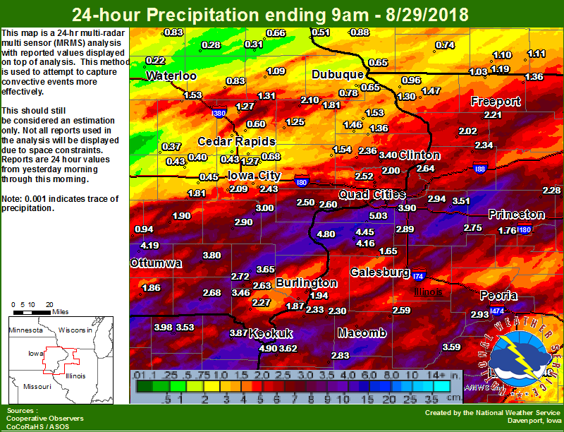
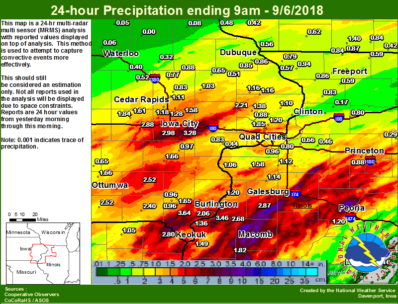
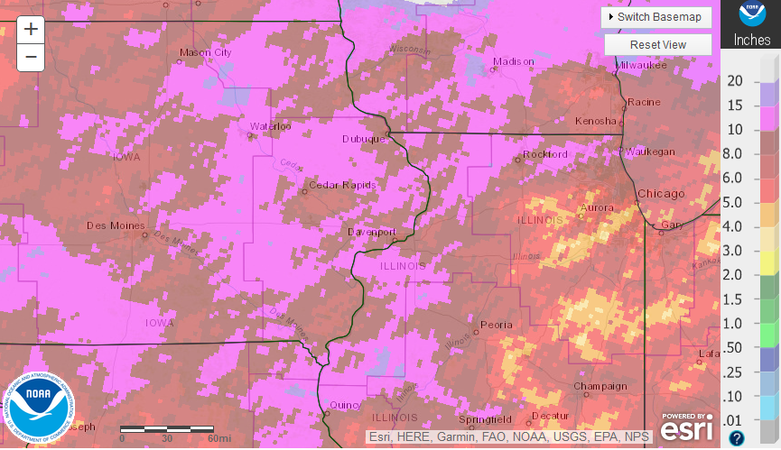
Rain Reports
 |
 |
 |
|
| Figure 1: Local 24-hr Rainfall ending 9 am 8/29 |
Figure 1: Local 24-hr Rainfall ending 9 am 9/6 |
Figure 2: Regional 7-Day Rainfall Ending 7am 9/6 |
|
 |
|||
| 30 Day Observed Precipitation 8/16 - 9/15 |
Public Information Statement
National Weather Service Quad Cities IA IL
1141 AM CDT Fri Sep 7 2018

...Highest 5-day Rainfall Reports...

Observations are collected from a variety of sources with varying
equipment and exposures. We thank all volunteer weather observers
for their dedication. Not all data listed are considered official.

Location                     Amount    Time/Date       Lat/Lon

...Illinois...

...Bureau County...
1 NNW Princeton              2.14 in   1116 AM 09/07   41.40N/89.47W
Princeton                    1.69 in   0700 AM 09/07   41.38N/89.48W
1 SE Princeton               1.69 in   0700 AM 09/07   41.37N/89.45W

...Carroll County...
2 WSW Chadwick               7.61 in   0700 AM 09/07   42.00N/89.94W
Shannon                      5.83 in   0700 AM 09/07   42.15N/89.74W

...Hancock County...
La Harpe                     5.38 in   0700 AM 09/07   40.58N/90.97W
La Harpe                     4.34 in   1000 AM 09/07   40.58N/90.96W
3 ENE Bentley                2.74 in   1107 AM 09/07   40.36N/91.06W
Keokuk L/D 19                2.34 in   1110 AM 09/07   40.40N/91.37W

...Henderson County...
Stronghurst                  3.69 in   1120 AM 09/07   40.74N/90.91W

...Henry County...
1 E Kewanee                  3.02 in   0700 AM 09/07   41.25N/89.90W
2 WNW Nekoma                 2.60 in   0800 AM 09/07   41.19N/90.23W

...Jo Daviess County...
Galena                       3.92 in   0700 AM 09/07   42.42N/90.43W
Galena Territory             3.65 in   1115 AM 09/07   42.41N/90.35W
Bellevue L/D 12              2.20 in   1100 AM 09/07   42.27N/90.42W

...McDonough County...
La Moine Rvr At Colmar       3.89 in   1045 AM 09/07   40.33N/90.90W

...Mercer County...
Pope Crk Near Keithsburg     3.51 in   1030 AM 09/07   41.13N/90.92W
Aledo                        3.48 in   0700 AM 09/07   41.22N/90.75W
New Boston L/D 17            2.65 in   1110 AM 09/07   41.18N/91.05W
Aledo                        2.28 in   1117 AM 09/07   41.21N/90.76W
Edwards Rvr At New Boston    1.73 in   1030 AM 09/07   41.19N/90.97W

...Rock Island County...
Illinois City L/D 16         4.57 in   1100 AM 09/07   41.42N/91.02W
3 NW Eliza                   3.45 in   0745 AM 09/07   41.34N/91.01W
Ms Rvr At Muscatine          3.15 in   1115 AM 09/07   41.38N/91.05W
1 ENE Oak Grove              2.84 in   1133 AM 09/07   41.42N/90.55W
Quad City Intl Arpt          2.78 in   0652 AM 09/07   41.45N/90.51W
Ms Rvr At Fairport           2.49 in   1130 AM 09/07   41.43N/90.88W
Rock Island L/D 15           2.38 in   1100 AM 09/07   41.52N/90.57W

...Stephenson County...
Pec Rvr At Freeport          5.36 in   1030 AM 09/07   42.30N/89.62W
Davis                        4.67 in   0600 AM 09/07   42.43N/89.42W
2 ESE Scioto Mills           4.66 in   1123 AM 09/07   42.33N/89.63W

...Warren County...
Alexis                       4.49 in   0715 AM 09/07   41.05N/90.57W

...Whiteside County...
Rock Falls                   5.32 in   0700 AM 09/07   41.78N/89.68W
Rock Rvr At Como             3.92 in   1030 AM 09/07   41.78N/89.75W
Unionville                   3.60 in   1125 AM 09/07   41.82N/89.98W
1 NE Sterling                2.66 in   1129 AM 09/07   41.82N/89.67W
Fulton L/D 13                1.83 in   1100 AM 09/07   41.92N/90.15W


...Iowa...

...Benton County...
Cedar Rvr At Vinton          4.95 in   1115 AM 09/07   42.17N/92.02W
Vinton                       4.04 in   1134 AM 09/07   42.15N/92.03W
Urbana                       3.37 in   1130 AM 09/07   42.22N/91.88W

...Buchanan County...
Independence                 4.36 in   1117 AM 09/07   42.47N/91.88W
Independence                 4.31 in   0700 AM 09/07   42.47N/91.91W
1 N Independence             3.73 in   1130 AM 09/07   42.48N/91.89W
Independence                 3.59 in   1128 AM 09/07   42.47N/91.89W
Buchanan Co Mobile Trailer   3.51 in   1119 AM 09/07   42.49N/91.86W
Wapsi Rvr At Independence    3.41 in   1130 AM 09/07   42.45N/91.89W
Winthrop                     2.96 in   1128 AM 09/07   42.47N/91.73W
Aurora                       2.45 in   1128 AM 09/07   42.62N/91.73W
Hazleton                     2.39 in   1117 AM 09/07   42.62N/91.91W
Fontana County Park          1.96 in   1117 AM 09/07   42.60N/91.91W
Lamont                       1.52 in   1125 AM 09/07   42.60N/91.64W

...Cedar County...
Hoover Crk Near West Branch  4.53 in   1045 AM 09/07   41.67N/91.35W
Lowden                       3.70 in   0700 AM 09/07   41.87N/90.93W
Cedar Rvr At Cedar Bluff     1.83 in   1100 AM 09/07   41.79N/91.31W

...Clinton County...
2 NW Fulton                  3.43 in   1116 AM 09/07   41.89N/90.19W

...Delaware County...
Maquoketa Rvr At Manchester  3.58 in   1115 AM 09/07   42.47N/91.45W

...Des Moines County...
Henderson Crk At Oquawka     5.16 in   1030 AM 09/07   40.92N/91.00W
Burlington Arpt              3.43 in   0653 AM 09/07   40.78N/91.13W
Ms Rvr At Burlington         3.26 in   1100 AM 09/07   40.82N/91.10W
1 WSW Spring Grove           3.15 in   0700 AM 09/07   40.73N/91.19W
Gladstone L/D 18             2.94 in   1100 AM 09/07   40.88N/91.03W
Skunk Rvr At Augusta, IA     2.43 in   1030 AM 09/07   40.77N/91.28W
3 W Pleasant Grove           1.75 in   1042 AM 09/07   40.97N/91.34W

...Dubuque County...
Center Grove                 4.86 in   1114 AM 09/07   42.49N/90.73W
Cascade                      3.98 in   0700 AM 09/07   42.30N/91.02W
Dubuque Arpt                 3.92 in   0653 AM 09/07   42.40N/90.71W
1 N Center Grove             2.73 in   0700 AM 09/07   42.50N/90.72W
Dubuque L/D 11               2.41 in   1100 AM 09/07   42.54N/90.65W
1 E Dubuque                  2.05 in   1131 AM 09/07   42.51N/90.67W
1 ESE Dubuque                1.91 in   1132 AM 09/07   42.50N/90.67W
Ms Rvr At Dubuque            1.87 in   1130 AM 09/07   42.50N/90.65W

...Henry County...
Cedar Crk Near Oakland Mills 2.29 in   1030 AM 09/07   40.93N/91.67W
Salem 1 S                    2.16 in   0700 AM 09/07   40.83N/91.62W

...Iowa County...
Iowa Rvr Near Belle Plaine   3.97 in   1100 AM 09/07   41.86N/92.28W
Williamsburg                 3.80 in   0700 AM 09/07   41.67N/92.02W
Williamsburg                 1.85 in   1129 AM 09/07   41.66N/92.00W
English Rvr Near Parnell     1.54 in   1100 AM 09/07   41.53N/91.99W

...Jackson County...
4 W Maquoketa                3.27 in   0700 AM 09/07   42.07N/90.70W

...Jefferson County...
Fairfield                    3.08 in   0800 AM 09/07   41.03N/91.95W

...Johnson County...
1 E Coralville               6.39 in   1111 AM 09/07   41.69N/91.58W
Iowa City Arpt               3.48 in   0652 AM 09/07   41.64N/91.55W
3 E Iowa City                2.44 in   1122 AM 09/07   41.65N/91.48W
Clear Crk At Coralville      2.28 in   1100 AM 09/07   41.68N/91.60W
Clear Crk Near Oxford        2.19 in   1045 AM 09/07   41.72N/91.74W
Iowa Rvr At Iowa City        1.81 in   1100 AM 09/07   41.66N/91.54W

...Jones County...
Monticello                   3.61 in   0720 AM 09/07   42.25N/91.17W
Wapsi Rvr At Anamosa         3.13 in   1115 AM 09/07   42.08N/91.27W
1 NNE Olin                   2.92 in   1125 AM 09/07   42.02N/91.13W

...Keokuk County...
Skunk Rvr At Sigourney       4.81 in   1030 AM 09/07   41.30N/92.20W

...Lee County...
Donnellson                   5.52 in   0700 AM 09/07   40.63N/91.57W

...Linn County...
Coggon                       5.42 in   0500 AM 09/07   42.28N/91.53W
2 ENE Cedar Rapids           4.84 in   1120 AM 09/07   42.00N/91.63W
Cedar Rvr Near Palo          3.86 in   1115 AM 09/07   42.07N/91.78W
Marion                       3.53 in   1125 AM 09/07   42.04N/91.58W
Cedar Rapids Arpt            2.80 in   0652 AM 09/07   41.88N/91.71W
Midway                       2.75 in   1120 AM 09/07   42.10N/91.70W
3 NNW Ely                    1.74 in   1129 AM 09/07   41.93N/91.62W

...Louisa County...
Iowa Rvr At Columbus Jct     3.91 in   1100 AM 09/07   41.28N/91.35W
Ms Rvr At Keithsburg         2.98 in   1030 AM 09/07   41.10N/90.95W

...Muscatine County...
2 N Muscatine                4.67 in   0700 AM 09/07   41.47N/91.04W

...Scott County...
Davenport Arpt               4.21 in   0652 AM 09/07   41.61N/90.59W
Eldridge                     4.13 in   0800 AM 09/07   41.64N/90.59W
NWS Davenport                3.99 in   0700 AM 09/07   41.61N/90.58W
1 SE Davenport               3.78 in   0655 AM 09/07   41.54N/90.59W
Park View                    3.65 in   0700 AM 09/07   41.69N/90.54W
1 WSW Bettendorf             2.91 in   0700 AM 09/07   41.55N/90.51W
1 WNW Eldridge               2.66 in   1117 AM 09/07   41.65N/90.59W
Le Claire L/D 14             2.39 in   1100 AM 09/07   41.58N/90.42W

...Van Buren County...
Farmington                   4.91 in   1107 AM 09/07   40.65N/91.72W
Keosauqua                    3.31 in   1115 AM 09/07   40.73N/91.97W

...Washington County...
5 NE Brighton                4.49 in   0600 AM 09/07   41.24N/91.77W

...Missouri...

...Clark County...
Fox Rvr At Wayland           1.82 in   1030 AM 09/07   40.39N/91.60W

...Scotland County...
Memphis                      2.93 in   0600 AM 09/07   40.46N/92.17W
Environment
WPC Mesoscale Precipitation Discussions (MPDs)
 |
 |
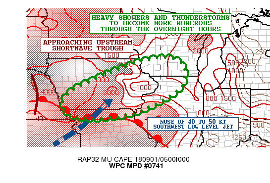 |
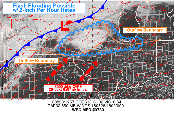
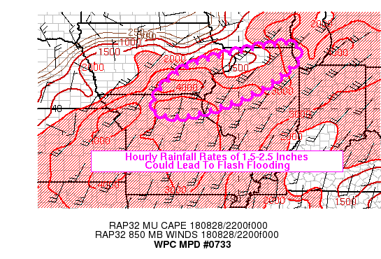
| Figure 1: MPD # 730 | Figure 2: MPD # 733 | Figure 3: MPD # 741 |
 |
 |
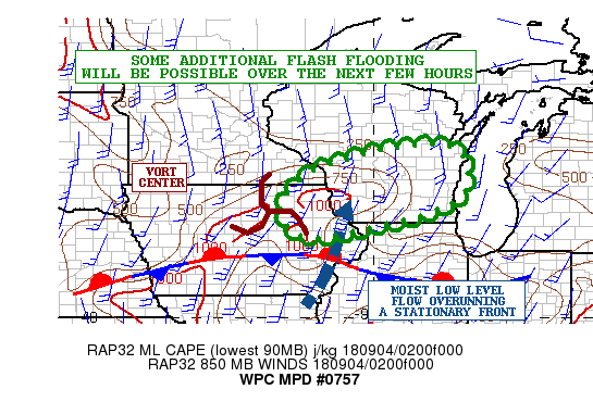 |
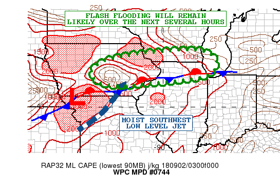
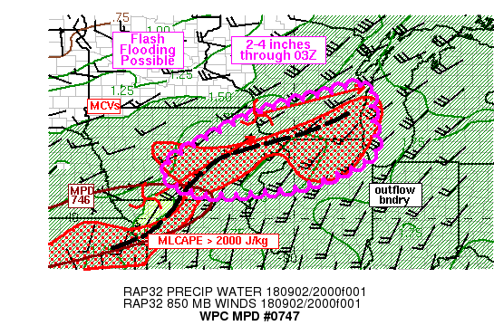
| Figure 4: MPD # 744 | Figure 5: MPD # 747 | Figure 6: MPD # 757 |
 |
||
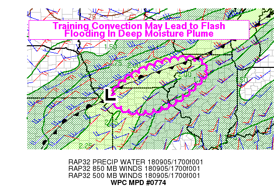
| Figure 7: MPD # 774 |
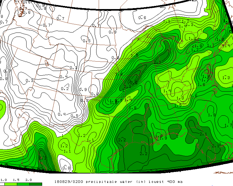
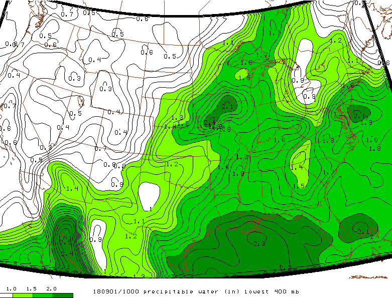
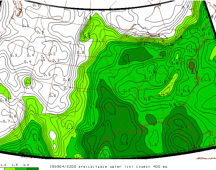
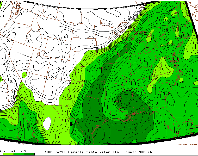
Precipitable Water:
 |
 |
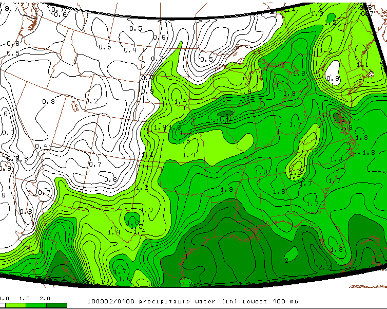 |
| Figure 8: 8/29 02z | Figure 9: 9/1 10z | Figure 10: 9/2 04z |
 |
 |
|
| Figure 11: 9/4 02z | Figure 12: 9/5 20z |
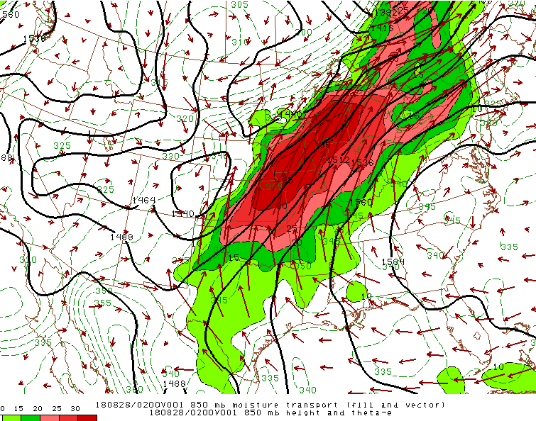
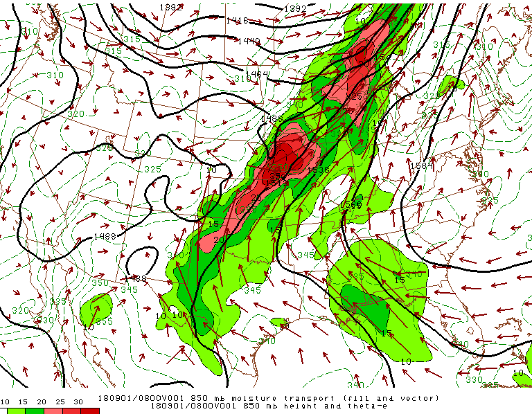
850 mb Moisture Transport
 |
 |
|
| Figure 13: 8/28 02z | Figure 14: 9/1 01z |
Additional Information
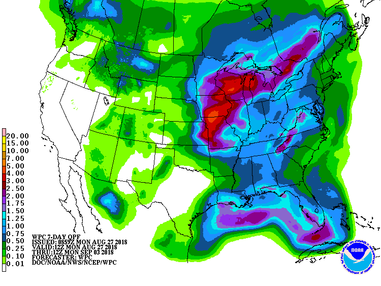
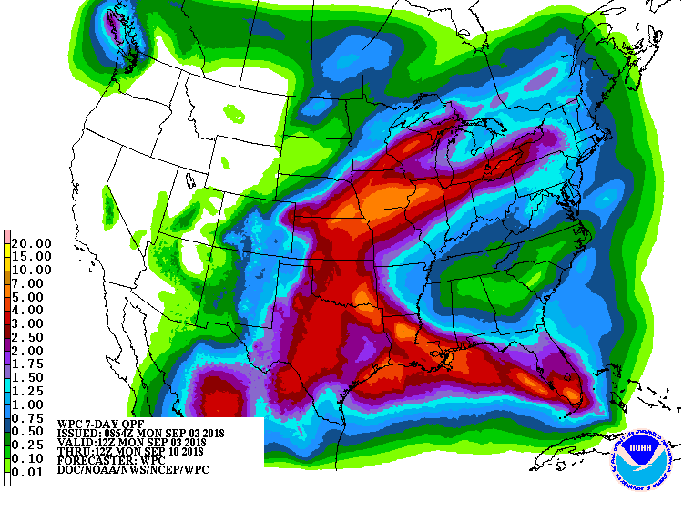
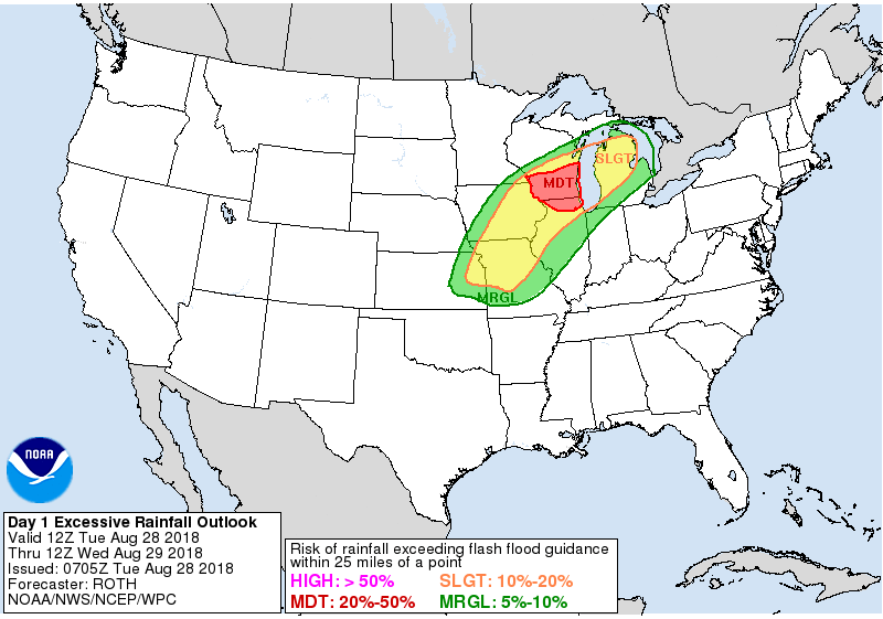
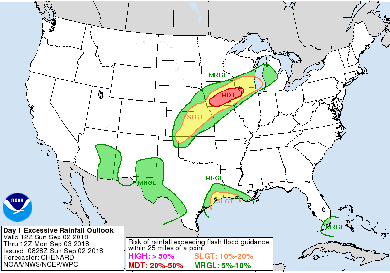
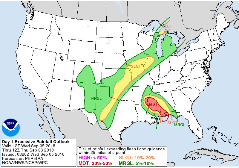
The Forecast
 |
 |
 |
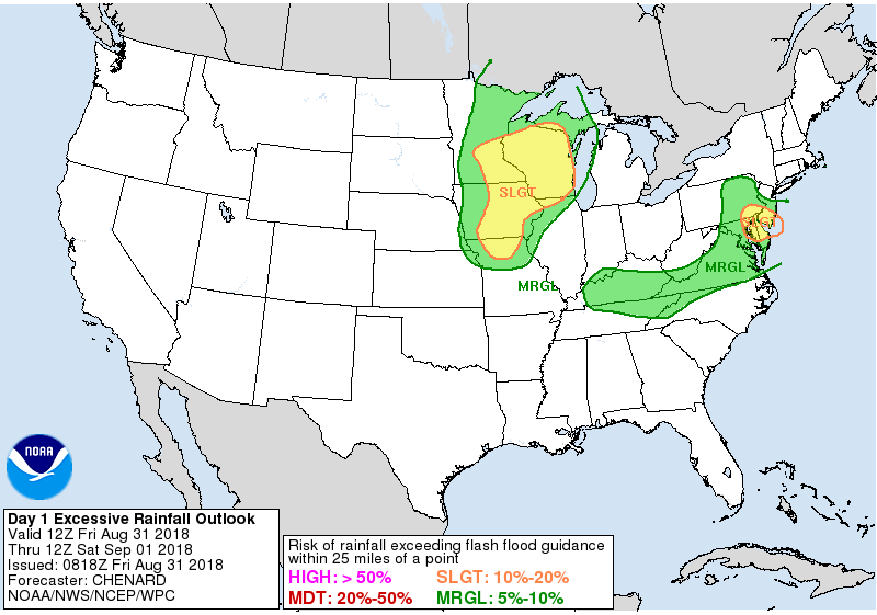 |
| WPC 7 Day Precipitation Forecast from Valid 8/27 - 9/3 | WPC 7 Day Precipitation Forecast from Valid 9/3 - 9/10 | WPC Day 1 Excessive Rainfall Outlook for 8/28 | WPC Day 1 Excessive Rainfall Outlook for 8/31 |
 |
 |
 |
|
| WPC Day 1 Excessive Rainfall Outlook for 9/2 | WPC Day 1 Excessive Rainfall Outlook for 9/3 | WPC Day 1 Excessive Rainfall Outlook for 9/5 |
Summaries from other NWS Offices
 |
Media use of NWS Web News Stories is encouraged! Please acknowledge the NWS as the source of any news information accessed from this site. |
|