Overview
|
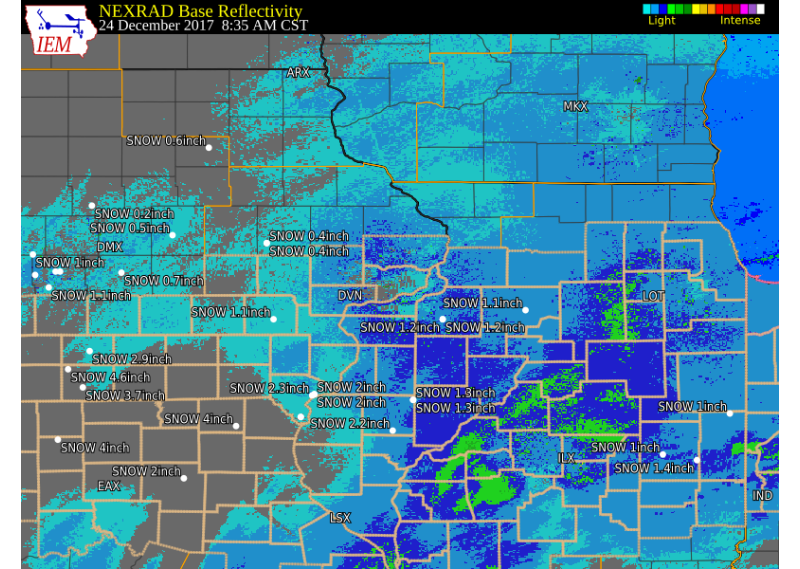
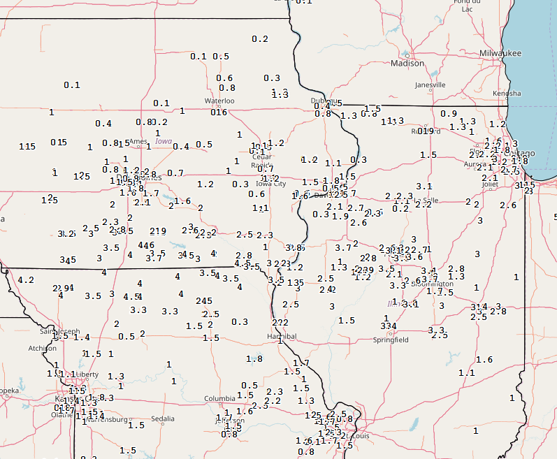
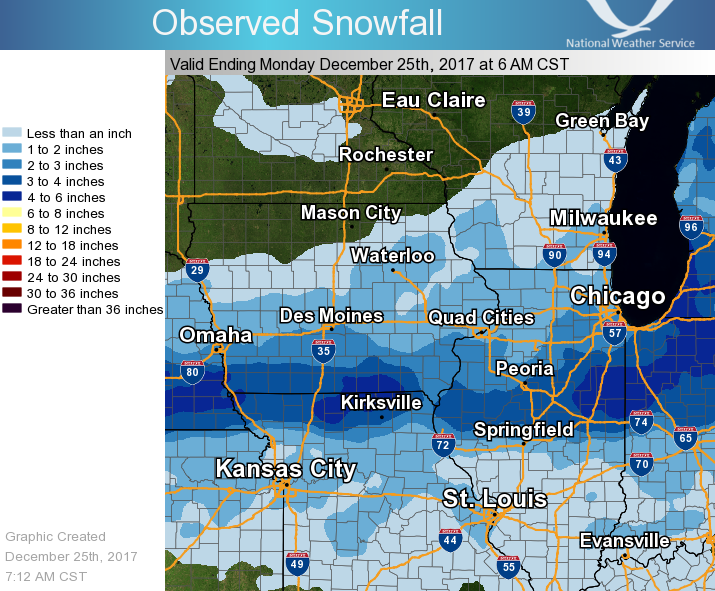
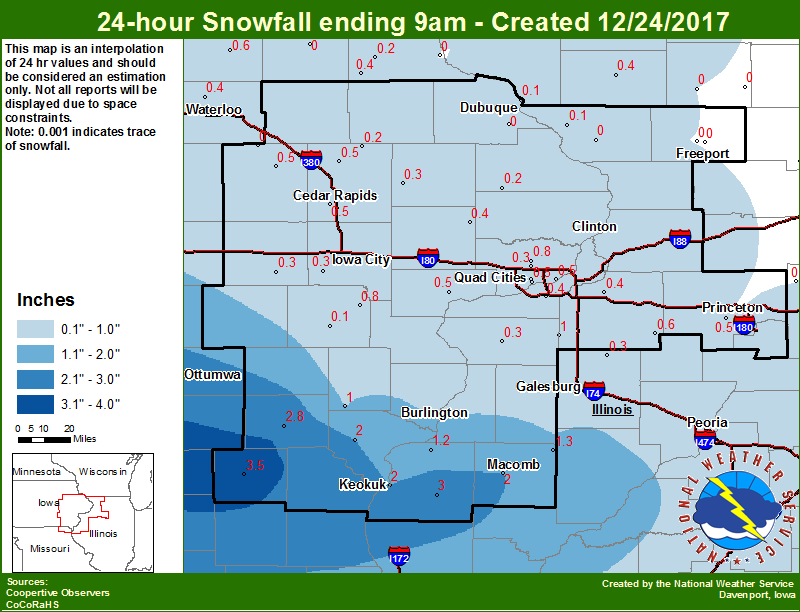
Low pressure moved across northern Missouri into the Ohio River Valley on Christmas Eve, and brought light snow to the middle Mississippi River Valley. Across eastern Iowa, northwest Illinois, and northeast Missouri total snow amounts ranged from a few tenths to around 4 inches, with the heaviest amounts falling over southeast Iowa, west central Illinois and northeast Missouri.
Summaries from other NWS Offices |
 Midwest Snow Analysis - Courtesy Iowa Environmental Mesonet |
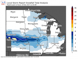
Storm Reports
 |
 |
 |
|
| Interactive Map Link | Regional Snow Analysis | Local Snowfall | |
SNOW REPORTS LISTED BY AMOUNT ...Snowfall Reports... Location Amount Time/Date Lat/Lon Industry 4.0 in 0250 PM 12/24 40.33N/90.61W West Burlington 3.8 in 0347 PM 12/24 40.82N/91.18W 3 ENE Charlie Heath Memorial 3.5 in 1148 AM 12/24 40.60N/91.84W Coal Valley 3.5 in 0207 PM 12/24 41.45N/90.45W Carthage 3.0 in 1203 PM 12/24 40.41N/91.13W Cambridge 2.7 in 0412 PM 12/24 41.30N/90.20W 3 NNW Oakland Mills 2.3 in 0101 PM 12/24 40.97N/91.63W 1 SSW Kewanee 2.3 in 1219 PM 12/24 41.23N/89.93W 2 WNW Dover 2.3 in 1252 PM 12/24 41.44N/89.43W 1 WSW Sherrard 2.1 in 1243 PM 12/24 41.31N/90.53W 2 SW Manlius 2.0 in 0305 PM 12/24 41.44N/89.69W Moline Quad-City Airport 2.0 in 0556 PM 12/24 41.45N/90.50W 1 E New Windsor 1.9 in 1124 AM 12/24 41.20N/90.44W Davenport Municipality 1.8 in 0415 PM 12/24 41.62N/90.58W 1 E Green River 1.7 in 0118 PM 12/24 41.47N/90.32W 2 NNW Muscatine 1.6 in 1256 PM 12/24 41.44N/91.08W 1 ENE Nora 1.5 in 0342 PM 12/24 42.46N/89.93W 1 SW Cordova 1.5 in 1144 AM 12/24 41.67N/90.33W Durant 1.5 in 0250 PM 12/24 41.60N/90.91W Davenport Municipality 1.5 in 1154 AM 12/24 41.62N/90.58W 3 NW Greeley 1.3 in 0101 PM 12/24 42.62N/91.38W 2 SE Galena Territory 1.3 in 0400 PM 12/24 42.38N/90.31W 3 SW Winneshiek 1.3 in 0313 PM 12/24 42.32N/89.57W 1 ENE Iowa City Municipality 1.2 in 0250 PM 12/24 41.64N/91.53W Lowden 1.2 in 1222 PM 12/24 41.86N/90.92W Springville 1.2 in 0245 PM 12/24 42.06N/91.45W 2 WSW Hiawatha 1.1 in 1252 PM 12/24 42.03N/91.72W Dewitt 1.1 in 1148 AM 12/24 41.82N/90.55W 2 WNW Freeport 1.1 in 0303 PM 12/24 42.30N/89.67W 1 WSW University Heights 1.1 in 1148 AM 12/24 41.65N/91.57W 2 SSE Cedar Rapids 1.0 in 0301 PM 12/24 41.95N/91.66W 4 N Marengo 1.0 in 1229 PM 12/24 41.85N/92.07W 2 SSW Ladora 1.0 in 0118 PM 12/24 41.73N/92.20W Dubuque Regional Arpt 0.8 in 1154 AM 12/24 42.40N/90.72W Observations are collected from a variety of sources with varying equipment and exposures. We thank all volunteer weather observers for their dedication. Not all data listed are considered official. |
|||
 |
Media use of NWS Web News Stories is encouraged! Please acknowledge the NWS as the source of any news information accessed from this site. |
|