Showers and thunderstorms will be possible from the northern Plains to the Gulf Coast on Monday. Thunderstorms with large hail and severe wind gusts are expected Monday afternoon and evening across parts of the central Plains. Read More >
Storm Overview
|
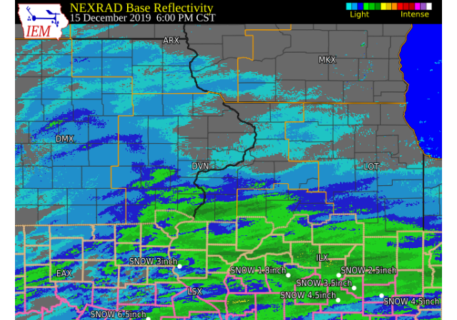
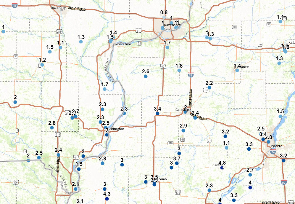
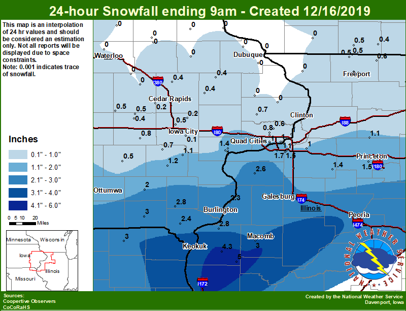
A passing storm system that developed over the central Great Plains brought widespread light to moderate snow to all of southeastern Iowa, west central Illinois and northeast Missouri on Dec 15-16, 2019. Snow began during the midday on December 15th, and lasted to around midnight on December 16th before tapering off from west to east. Snowfall totals were highest generally along and south of the Highway 34 corridor. To the north, amounts of 1-3 inches were common up to the I-80 corridor. To the south, reports were around 3-4 inches. A report of 5 inches was received from an NWS Cooperative Observing Station in Augusta, IL.
Official National Weather Service Observations Moline: 1.7" Davenport: 0.8" Dubuque: N/A
***Cedar Rapids, Iowa City and Burlington do not measure snow as part of their climate records. Please see the Snowfall Amounts and Storm Reports sections for reported snow amounts in these locations.*** |
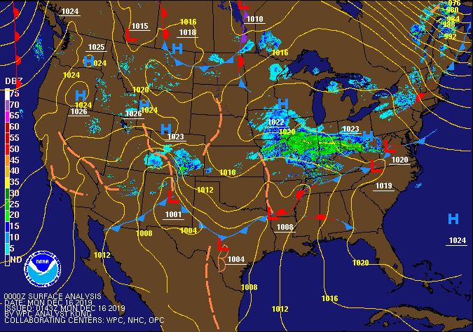 WPC - Surface Map and Radar Loop |
Snowfall Amounts
| Local Snowfall Map Dec 16 |
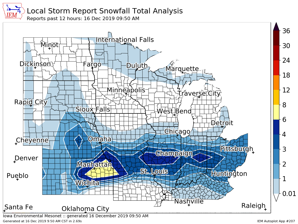
Regional Snowfall Map Dec 16 |
 |
 |
24 hour snow fall in inches,
for eastern Iowa, northwest and west central Illinois,
and northeast Missouri. Reported between Midnight and 9 AM,
Monday December 16, 2019.

....IOWA....
Keosauqua                         3.0
Salem 1S                          2.8
Donnellson                        2.4
Centerville 0 NE                  2.3
Fairfield                         2.0
Muscatine 2N                      1.4
Washington                        1.2
Ainsworth 7.4 N                   1.1
Bettendorf 2.2 SE                 1.0
Beaconsfield 1 NNE                1.0
Muscatine 2.1 N                   1.0
Davenport 0.9 WNW                 1.0
Davenport 0.9 SSW                 1.0
Riverdale 0.5 N                   1.0
Le Claire 1.8 NNE                 1.0
Toledo 3 N                        1.0
Eldridge 0.7 SSW                  0.8
Davenport Arpt                    0.8
Parnell 0.1 SSW                   0.8
Wellman 4.0 E                     0.7
Calamus 2.0 NE                    0.7
Park View 0.2 WSW                 0.6
Mason City 1 NNE                  0.5
Marengo 3.6 N                     0.5
North Liberty 0.7 SSW             0.5
Sigourney                         0.5
Belle Plaine                      0.5
Central City 6.7 W                0.4
Marengo                           0.4
Anamosa 3 SSW                     0.4
Monticello 1 E                    0.4
NWS Johnston* 5 NNW               0.3
Boone 1 SSW                       0.2
Perry 0 W                         0.2
Fairfax 4.0 NW                    0.2
Solon 0.3 ESE                     0.2
Iowa City                         0.1
Ames US 30 2 SSE                  0.0
Stanley                           0.0
Oelwein 1E                        0.0
Cresco 1 NE                       0.0
Manchester                        0.0
Marshalltown 1 NW                 0.0
Charlotte 1.9 WNW                 0.0
Waterloo ASOS 5 NW                0.0
Maquoketa 4 W                     0.0
Dubuque LD11                      0.0
Mount Auburn 2.2 NNW              0.0
Rickardsville 0.2 W               0.0
Tripoli 0 N                       0.0
Vinton                            0.0
Fayette 1 NW                      0.0
Dubuque Arpt                      0.0
Hampton 1 N                       0.0
Guttenberg Dam 10                 0.0
Elkader 6SSW                      0.0
....ILLINOIS....
Augusta                           5.0
Bentley                           4.3
Colchester 3.5 NE                 3.0
Dallas City 3.0 SSE               2.8
Aledo                             2.6
St Anne                           2.5
Gladstone LD18                    2.3
Quad City Arpt                    1.7
Princeton 1.1 SE                  1.6
Princeton                         1.6
Ottawa 4 SW                       1.5
Tiskilwa 2.1 N                    1.5
Coal Valley 1.9 SE                1.5
Kewanee 1 E                       1.4
Walnut 5.3 ENE                    1.1
Romeoville                        1.0
Coal Valley 2.6 E                 1.0
Geneseo 2.0 NW                    1.0
Paw Paw 1 E                       0.8
Rockford ASOS                     0.6
Davis 0.5 N                       0.6
Freeport 1.7 ESE                  0.5
Freeport 2.0 NW                   0.5
Orangeville 2.8 NW                0.5
Winslow 4.3 ESE                   0.5
Freeport 2.9 WSW                  0.5
Freeport 1.7 NW                   0.5
Steward                           0.4
Freeport                          0.4
Mundelein                         0.3
Elizabeth                         0.0
....MISSOURI....
Memphis                           3.0
Columbia                          1.8
....WISCONSIN....
Beloit-College                    1.0
Whitewater                        0.8
Monroe 1 W                        0.5
Brodhead 1 SW                     0.4
Delavan-1 W-WWTP 1 W              0.3
Madison-ASOS                      0.2
La Crosse WFO                     0.0
Viroqua                           0.0
Darlington                        0.0
Steuben 4SE 3 NE                  0.0
....MINNESOTA....
Grand Meadow                      0.0
|
Storm Reports
Storm Reports Map - Courtesy IEM
|
|
PUBLIC INFORMATION STATEMENT NATIONAL WEATHER SERVICE QUAD CITIES IA IL 959 AM CST MON DEC 16 2019 ...DECEMBER 15-16, 2019 SNOWFALL TOTALS... LOCATION AMOUNT TIME/DATE PROVIDER AUGUSTA 5.0 IN 0521 AM 12/16 COOP BENTLEY 4.3 IN 0700 AM 12/16 COOP 2.0 S PRAIRIE CITY 3.7 IN 0600 AM 12/16 UCOOP MONMOUTH 2 NNE 3.4 IN 0730 AM 12/16 COOP WARSAW 5.8 SE 3.1 IN 0700 AM 12/16 COCORAHS 1 NE FORT MADISON 3.0 IN 0943 AM 12/16 TRAINED SPOTTER LA HARPE 3.0 IN 0800 AM 12/16 COOP BUSHNELL 3.0 IN 0704 AM 12/16 TRAINED SPOTTER COLCHESTER 3.5 NE 3.0 IN 0700 AM 12/16 COCORAHS MEMPHIS 3.0 IN 0600 AM 12/16 COOP CARTHAGE 3.0 IN 0507 AM 12/16 TRAINED SPOTTER SALEM 1 S 2.8 IN 0700 AM 12/16 COOP DALLAS CITY 3.0 SSE 2.8 IN 0600 AM 12/16 COCORAHS 1 ESE NEW LONDON 2.7 IN 0727 AM 12/16 TRAINED SPOTTER ALEDO 2.6 IN 0700 AM 12/16 COOP NEW LONDON 1.5 SW 2.6 IN 0700 AM 12/16 COCORAHS 2 N BURLINGTON 2.5 IN 0825 AM 12/16 TRAINED SPOTTER DONNELLSON 2.4 IN 0700 AM 12/16 COOP 3 NE BEAVERDALE 2.3 IN 0857 AM 12/16 TRAINED SPOTTER 2 N SPERRY 2.3 IN 0833 AM 12/16 TRAINED SPOTTER OQUAWKA 0.5 N 2.3 IN 0800 AM 12/16 COCORAHS FAIRFIELD 2.0 IN 0800 AM 12/16 COOP 2 E GRIFFIN 1.8 IN 0631 AM 12/16 TRAINED SPOTTER WAPELLO 5.4 SE 1.7 IN 0830 AM 12/16 COCORAHS PRINCETON 1.6 IN 0700 AM 12/16 COOP PRINCETON 1.1 SE 1.6 IN 0700 AM 12/16 COCORAHS 2 NNW MUSCATINE 1.5 IN 0827 AM 12/16 TRAINED SPOTTER KEWANEE 1 E 1.4 IN 0700 AM 12/16 COOP 2 N MUSCATINE 1.4 IN 0700 AM 12/16 COOP 1 N GENESEO 1.3 IN 0509 AM 12/16 TRAINED SPOTTER WASHINGTON 2 SSW 1.2 IN 0700 AM 12/16 COOP WALNUT 5.3 ENE 1.1 IN 0700 AM 12/16 COCORAHS AINSWORTH 7.4 N 1.1 IN 0700 AM 12/16 COCORAHS 2 W BETTENDORF 1.0 IN 0713 AM 12/16 NWS EMPLOYEE MUSCATINE 2.1 N 1.0 IN 0700 AM 12/16 COCORAHS NORTH ENGLISH 1.0 IN 0700 AM 12/16 COOP RIVERDALE 0.5 N 1.0 IN 0700 AM 12/16 COCORAHS BETTENDORF 2.2 SE 1.0 IN 0630 AM 12/16 COCORAHS DAVENPORT 0.9 WNW 1.0 IN 0606 AM 12/16 COCORAHS DAVENPORT 0.9 SSW 1.0 IN 0530 AM 12/16 COCORAHS GENESEO 2.0 NW 1.0 IN 0500 AM 12/16 COCORAHS OBSERVATIONS ARE COLLECTED FROM A VARIETY OF SOURCES WITH VARYING EQUIPMENT AND EXPOSURES. WE THANK ALL VOLUNTEER WEATHER OBSERVERS FOR THEIR DEDICATION. NOT ALL DATA LISTED ARE CONSIDERED OFFICIAL. |
 |
Media use of NWS Web News Stories is encouraged! Please acknowledge the NWS as the source of any news information accessed from this site. |
|