Scattered severe thunderstorms capable of damaging wind gusts and some hail are expected this afternoon and evening from the Upper Ohio River Valley into the Northeast, and from the Appalachians into the Mid-Atlantic States. Excessive rainfall from heavy thunderstorms may produce areas of flash flooding from southern New Mexico into the western and northern Gulf Coast into Wednesday. Read More >
Overview
|
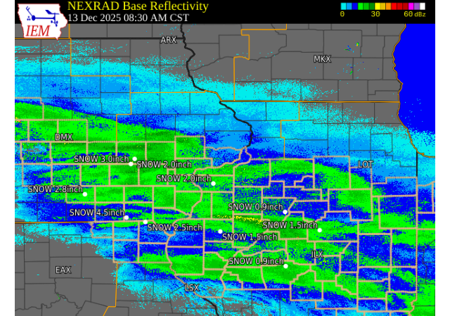
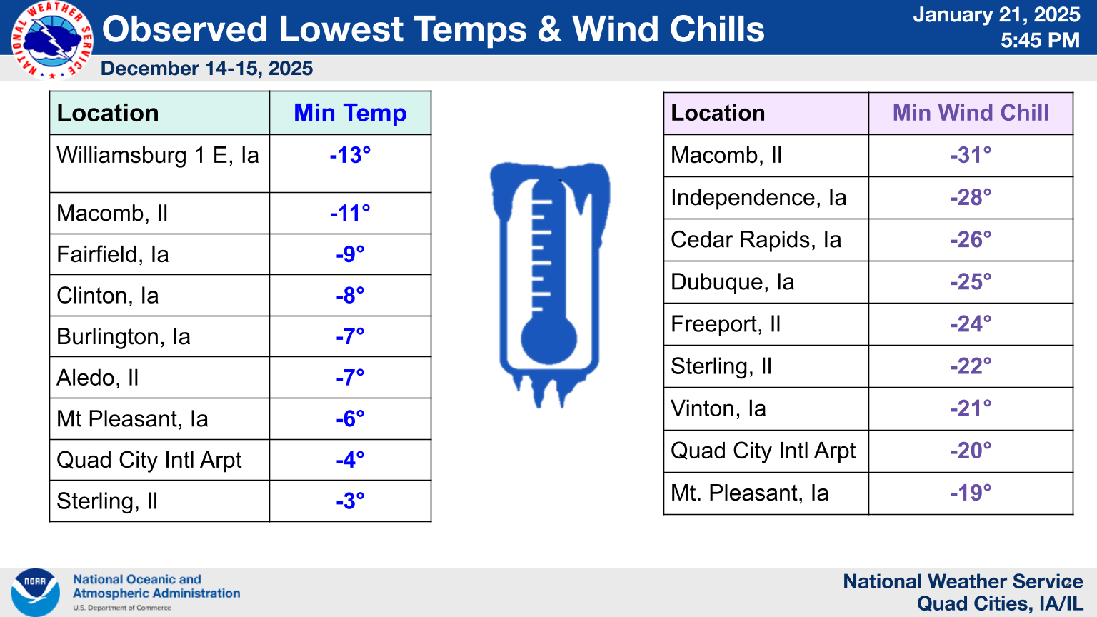
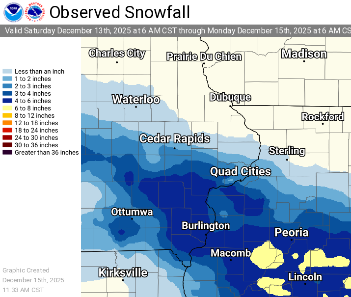
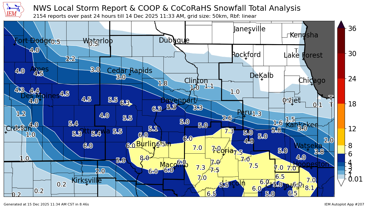
A fast moving clipper system overspread the region on the morning of December 13th. In general, a widespread 2 to 5 inch event occurred along and south of the Highway 30 corridor. There were some very localized swaths of 6 inches or more from southwest of Iowa City to Wapello and Muscatine IA, and from far southeastern IA into portions of west central IL. The greatest impact was dangerous travel conditions on Interstate 80 in Iowa, where several multi-vehicle accidents resulted in the highway being closed much of the afternoon and evening. In addition, temperatures dropped sharply behind the departing system, with sub-zero air temperatures and wind chills in the -20 to -30 degree F range for several hours Sunday morning Dec 14th. NWS Official Totals Moline: 3.8"
|
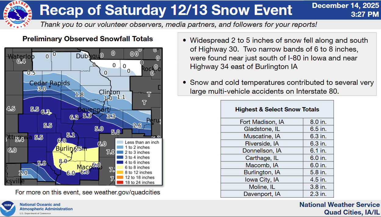 Snow Summary Infographic |
 |
  |
| Temperature / Wind Chill Infographic | Top Image: I-80 MM 206 near Willamsburg, IA (926 am 12/13) Bottom Image: I-80 MM 267 near Tipton, IA (422 pm 12/13) Images Courtesy: IA DOT (click to enlarge) |
Snow Maps
| Local Snowfall Map | Regional Snow Map (courtesy IEM) | |
 |
 |
|
Storm Reports
Storm Reports Map - Courtesy IEM
 |
Snow Reports Listed By Amount

 INCHES  LOCATION                 ST  COUNTY           TIME
 ------  -----------------------  --  --------------   -------
  8.0    2 NE Fort Madison        IA  Lee              0451 PM
  6.5    Gladstone                IL  Henderson        1230 PM
  6.3    2 SW Williamstown        IA  Johnson          0200 PM
  6.3    Riverside                IA  Washington       0150 PM
  6.3    2 NE Muscatine           IA  Muscatine        1133 AM
  6.1    Donnellson               IA  Lee              0315 PM
  6.0    2 SW Yarmouth            IA  Des Moines       0431 PM
  6.0    1 SW Macomb              IL  Mcdonough        0400 PM
  6.0    2 N Burlington           IA  Des Moines       0317 PM
  6.0    2 N Muscatine            IA  Muscatine        0255 PM
  6.0    Colchester               IL  Mcdonough        0152 PM
  6.0    1 E Carthage             IL  Hancock          0141 PM
  6.0    1 NW Bushnell            IL  Mcdonough        0119 PM
  6.0    Muscatine                IA  Muscatine        1249 PM
  5.8    2 NE Riverside           IA  Washington       0430 PM
  5.7    2 NNE Muscatine          IA  Muscatine        0229 PM
  5.5    1 SE Washington          IA  Washington       0623 PM
  5.5    1 SW Perlee              IA  Jefferson        0253 PM
  5.5    3 E Rozetta              IL  Henderson        0221 PM
  5.5    Parnell                  IA  Iowa             0216 PM
  5.3    3 SE Macomb              IL  Mcdonough        0335 PM
  5.3    1 NNW Buffalo            IA  Scott            0158 PM
  5.2    1 S Montrose             IA  Lee              0331 PM
  5.0    1 W Williamsburg         IA  Iowa             1132 PM
  5.0    Galva                    IL  Henry            0739 PM
  5.0    2 NE New Windsor         IL  Henry            0356 PM
  5.0    3 ENE Charlie Heath Mem  MO  Clark            0250 PM
  5.0    1 W Beaverdale           IA  Des Moines       0200 PM
  5.0    North English            IA  Iowa             0144 PM
  5.0    4 SSE Sciota             IL  Mcdonough        0118 PM
  4.9    1 W Kewanee              IL  Henry            0338 PM
  4.9    1 SW University Heights  IA  Johnson          0237 PM
  4.8    1 N Williamsburg         IA  Iowa             0201 PM
  4.5    Biggsville               IL  Henderson        0531 PM
  4.5    Industry                 IL  Mcdonough        0502 PM
  4.5    Ferris                   IL  Hancock          0413 PM
  4.5    New Boston               IL  Mercer           0325 PM
  4.5    2 E Iowa City            IA  Johnson          1226 PM
  4.4    University Heights       IA  Johnson          0349 PM
  4.3    2 SSW Spring Lake        IA  Scott            1251 PM
  4.0    3 NE Hamilton            IL  Hancock          0424 PM
  4.0    Upper South Amana        IA  Iowa             0300 PM
  3.8    2 SW Florid              IL  Putnam           0724 PM
  3.8    Quad City Airport        IL  Rock Island      0418 PM
  3.8    2 N Oakland Mills        IA  Henry            0215 PM
  3.8    Solon                    IA  Johnson          0120 PM
  3.6    1 NE West Amana          IA  Iowa             0404 PM
  3.5    3 SSE Milo               IL  Bureau           0434 PM
  3.5    1 SW Cou Falls           IA  Johnson          0507 AM
  3.5    2 NW North Liberty       IA  Johnson          0255 PM
  3.5    1 NW Coal Valley         IL  Rock Island      0243 PM
  3.5    Belle Plaine             IA  Benton           0225 PM
  3.5    New London               IA  Henry            0135 PM
  3.5    1 N Oakdale              IA  Johnson          1251 PM
  3.4    1 NNE Moline             IL  Rock Island      0332 PM
  3.3    Geneseo                  IL  Henry            0438 PM
  3.3    1 SE Davenport           IA  Scott            0433 PM
  3.1    Moline                   IL  Rock Island      0241 PM
  3.0    1 NE Keokuk              IA  Lee              0615 PM
  3.0    1 W Oakdale              IA  Johnson          0304 PM
  3.0    Green River              IL  Henry            0225 PM
  2.6    Tiskilwa                 IL  Bureau           0300 PM
  2.3    2 W Bettendorf           IA  Scott            0557 PM
  2.3    Davenport Airport        IA  Scott            0423 PM
  2.1    2 NW Cedar Rapids        IA  Linn             0300 PM
  2.0    1 W Princeton            IL  Bureau           0624 PM
  2.0    Le Claire                IA  Scott            0351 PM
  2.0    4 S Crawford             MO  Scotland         0314 PM
  2.0    1 SW Silvis              IL  Rock Island      1145 AM
  1.8    1 NW Park View           IA  Scott            0332 PM
  1.8    Lowden                   IA  Cedar            0130 PM
  1.5    2 NW Rutledge            MO  Scotland         0629 PM
  1.5    2 NE Cedar Rapids        IA  Linn             1235 PM
  1.1    Stanwood                 IA  Cedar            0331 PM
  1.0    1 W Aledo                IL  Mercer           0312 PM
  1.0    Albany                   IL  Whiteside        0212 PM
  1.0    1 E Bertram              IA  Linn             1237 PM
  1.0    3 NE Cedar Rapids        IA  Linn             1152 AM
Reports
...OBSERVED LOW TEMPERATURES AND WIND CHILLS FROM DECEMBER 14-15... The following are lists of minimum observed temperatures and wind chills from early Sunday morning through early Monday morning. Observations are collected from a variety of sources with varying equipment and exposures. We thank all volunteer weather observers for their dedication. Not all data listed are considered official. .MINIMUM TEMPERATURES... Location Temp Time/Date Provider --------------------------------------------------------------- 1 E Williamsburg -13 F 0700 AM 12/14 COOP Washington Arpt -11 F 0735 AM 12/14 AWOS Cedar Rapids Arpt -11 F 0531 AM 12/14 ASOS Macomb Arpt -11 F 0755 AM 12/14 AWOS Fairfield Arpt -9 F 0650 AM 12/14 AWOS Fort Madison Arpt -9 F 0735 AM 12/14 AWOS Sigourney -9 F 0600 AM 12/14 COOP Donnellson -8 F 0700 AM 12/14 COOP Clinton Arpt -8 F 0835 AM 12/14 AWOS Davenport Arpt -8 F 0750 AM 12/14 ASOS Independence Arpt -8 F 0835 AM 12/14 AWOS Iowa City Arpt -8 F 0808 AM 12/14 ASOS La Harpe -8 F 0800 AM 12/14 COOP Manchester -8 F 0700 AM 12/14 COOP Stockton 3 Nne -8 F 0800 AM 12/14 COOP Aledo -7 F 0900 AM 12/14 COOP Fairfield -7 F 0800 AM 12/14 COOP Burlington Arpt -7 F 0815 AM 12/14 ASOS Dubuque Arpt -7 F 0802 AM 12/14 ASOS Keokuk Arpt -6 F 0815 AM 12/14 AWOS Mount Pleasant Arpt -6 F 0755 AM 12/14 AWOS Muscatine Arpt -6 F 0855 PM 12/14 AWOS Vinton Arpt -6 F 0815 AM 12/14 AWOS Elizabeth -5 F 0630 AM 12/14 COOP 2 N Muscatine -5 F 0700 AM 12/14 COOP Vinton -5 F 0800 AM 12/14 COOP Quad City Intl Arpt -4 F 0755 AM 12/14 ASOS Sterling/Rock Falls Arpt -3 F 0656 AM 12/14 AWOS .MINIMUM WIND CHILLS... Location WC Temp. Time/Date Provider --------------------------------------------------------------- Macomb Arpt -31 F 1215 AM 12/14 AWOS Independence Arpt -28 F 0655 AM 12/14 AWOS Washington Arpt -26 F 0755 AM 12/14 AWOS Cedar Rapids Arpt -26 F 0552 AM 12/14 ASOS Clinton Arpt -26 F 0556 AM 12/14 AWOS Fairfield Arpt -26 F 0810 AM 12/14 AWOS Dubuque Arpt -25 F 0753 AM 12/14 ASOS Davenport Arpt -25 F 0700 AM 12/14 ASOS Fort Madison Arpt -25 F 0715 AM 12/14 AWOS Freeport Arpt -24 F 0755 AM 12/14 AWOS Keokuk Arpt -22 F 0715 AM 12/14 AWOS Iowa City Arpt -22 F 0752 AM 12/14 ASOS Muscatine Arpt -22 F 0655 AM 12/14 AWOS Sterling/Rock Falls Arpt -22 F 0556 AM 12/14 AWOS Vinton Arpt -21 F 0715 AM 12/14 AWOS Burlington Arpt -20 F 0653 AM 12/14 ASOS Quad City Intl Arpt -20 F 0552 AM 12/14 ASOS Mount Pleasant Arpt -19 F 0755 AM 12/14 AWOS |
 |
Media use of NWS Web News Stories is encouraged! Please acknowledge the NWS as the source of any news information accessed from this site. |
|