Scattered severe thunderstorms capable of damaging wind gusts and some hail are expected this afternoon and evening from the Upper Ohio River Valley into the Northeast, and from the Appalachians into the Mid-Atlantic States. Excessive rainfall from heavy thunderstorms may produce areas of flash flooding from southern New Mexico into the western and northern Gulf Coast into Wednesday. Read More >
Overview
|
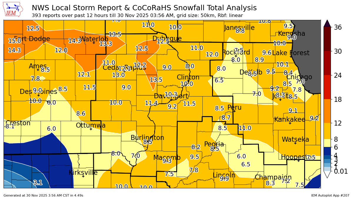
A long duration winter storm tracked across the region Friday night and Saturday. Widespread snowfall amounts over 8" were common, with some locations receiving over a foot of snow! This will likely go down as one of the highest snowfall events for any year for the month of November in eastern IA, northwest IL, and northeast MO. Numerous accidents including a few jackknifed semis on I-80 and I-74 and several road closures occurred with this event. Thank you to our many volunteer observers for your reports! NWS Official Totals Dubuque: 12.3" |
 Summary Infographic |
Fast Facts
Dubuque: The grand total of 12.3" for Dubuque makes this the snowiest system in meteorological autumn (September-November) on record for the city (using 3-day totals). This surpasses 12.2" on November 17-19, 1986 and 11.7" on November 20-21, 2015.
In addition, the 12.3" had 11.0" fall during the calendar day of November 29, making it the snowiest day in the month of November on record. Previous record was 10.3" on November 25, 1992.
This was the largest snow event in the city for anytime of the year since January 9, 2024 (12.6").
Dubuque averages a 10+" snow event about once every two years based on the last 30 years.
Moline: The total of 9.2" made this the 4th snowiest system in meteorological autumn (September-November) on record for the city (using 3-day totals). The top three are the November 25-26, 2018 blizzard (13.8"), the November 20-21, 2015 event (9.9"), and November 29-30, 1974 event (9.8").
Of the 9.2", there was 9.1" that fell on the calendar day of November 29, making it the 2nd snowiest day in the month of November on record. The current record is 13.3" on November 25, 2018.
This was the largest snow event in the city for anytime of the year since January 12-13, 2024 (15.4").
Moline saw more snow with this single event than it saw in the entirety of the previous winter (8.2")!
This one system resulted in November 2025 and Meteorological Autumn 2025 both being top ten snowiest on record for Dubuque and Moline. Climate Summary
For more climatological context, see our Snow Page and our History of Weather Observations Page.
Snow
| Local Storm Report Analysis (courtesy IEM) | Regional Storm Report Analysis (courtesy IEM) | |
 |
 |
|
| 48-hr Regional Snowfall | Local Storm Report Map | |
 |
 |
|
Snowfall Reports
...Highest Snowfall Amounts for Nov 29-30th Snowfall...

The reports below are separated into snow and ice and sleet
categories, then by amount, and are not necessarily the final
amount for each location.

Snow Reports Listed By Amount

 INCHES  LOCATION                 ST  COUNTY           TIME
 ------  -----------------------  --  --------------   -------
 14.8    Jesup                    IA  Buchanan         0905 AM
 14.0    2 SE Asbury              IA  Dubuque          0923 AM
 13.5    2 ENE Hazleton           IA  Buchanan         0900 PM
 13.5    Lowden                   IA  Cedar            0136 AM
 13.5    Aurora                   IA  Buchanan         0907 AM
 13.0    1 N Fairfax              IA  Linn             0615 PM
 12.5    3 N Hopkinton            IA  Delaware         0700 PM
 12.5    Asbury                   IA  Dubuque          0814 PM
 12.3    Dubuque Regional Arpt    IA  Dubuque          0614 AM
 12.3    2 NE Stone City          IA  Jones            0653 AM
 12.2    Anamosa                  IA  Jones            0325 AM
 12.1    2 E Hiawatha             IA  Linn             0959 PM
 12.0    1 W Dubuque              IA  Dubuque          0800 PM
 12.0    Freeport                 IL  Stephenson       1000 PM
 12.0    1 NE Moline              IL  Rock Island      0556 AM
 12.0    3 N Stockton             IL  Jo Daviess       0818 AM
 11.7    2 NW Cedar Rapids        IA  Linn             0927 PM
 11.5    Geneseo                  IL  Henry            0655 PM
 11.5    1 SE Manchester          IA  Delaware         0936 PM
 11.5    Marion                   IA  Linn             0715 AM
 11.5    1 SW Vinton              IA  Benton           1016 AM
 11.4    3 NE Muscatine           IA  Muscatine        0754 PM
 11.4    2 W Freeport             IL  Stephenson       0840 AM
 11.1    1 E Marion               IA  Linn             0536 PM
 11.0    1 E Vinton               IA  Benton           0400 PM
 11.0    1 SSE Manchester         IA  Delaware         0430 PM
 11.0    2 SSE Manchester         IA  Delaware         0630 PM
 11.0    2 W Marion               IA  Linn             0731 PM
 11.0    2 NW Woodbine            IL  Jo Daviess       0300 AM
 11.0    2 NE Cedar Rapids        IA  Linn             0402 AM
 11.0    1 NW Maquoketa           IA  Jackson          0524 AM
 11.0    1 SSE Edmore             IA  Dubuque          0904 AM
 11.0    1 NW Center Grove        IA  Dubuque          0934 AM
 11.0    1 NE Park View           IA  Scott            0705 PM
 10.9    1 NNE Moline             IL  Rock Island      1030 PM
 10.9    2 W Cedar Rapids         IA  Linn             1055 PM
 10.6    3 S Urbana               IA  Benton           0543 PM
 10.6    Davenport Airport        IA  Scott            0612 AM
 10.5    Shellsburg               IA  Benton           1010 PM
 10.5    1 W Elmira               IA  Johnson          0709 AM
 10.4    3 S Davis                IL  Stephenson       0900 AM
 10.2    2 NE Marion              IA  Linn             0418 PM
 10.2    1 NW Pleasant Valley     IA  Scott            0724 PM
 10.2    1 SW University Heights  IA  Johnson          0800 AM
 10.0    1 N Carbon Cliff         IL  Rock Island      0315 PM
 10.0    1 ENE Moline             IL  Rock Island      0510 PM
 10.0    Wellman                  IA  Washington       0517 PM
 10.0    Albany                   IL  Whiteside        0657 PM
 10.0    2 NW Marion              IA  Linn             0800 PM
 10.0    2 SW East Moline         IL  Rock Island      1000 PM
 10.0    Prophetstown             IL  Whiteside        0438 AM
 10.0    1 NW Fruitland           IL  Rock Island      0835 AM
 10.0    Le Claire                IA  Scott            0953 AM
  9.8    2 NW North Liberty       IA  Johnson          0931 AM
  9.7    3 SW Winneshiek          IL  Stephenson       0630 AM
  9.7    1 W Hennepin             IL  Putnam           0500 PM
  9.5    1 NW Geneseo             IL  Henry            0350 PM
  9.5    2 WSW Hiawatha           IA  Linn             0435 PM
  9.5    3 E Cedar Rapids         IA  Linn             0545 PM
  9.5    3 W Cedar Rapids         IA  Linn             0745 PM
  9.5    3 WSW Bettendorf         IA  Scott            0817 PM
  9.4    Erie                     IL  Whiteside        1033 AM
  9.3    4 SSE Cedar Rapids       IA  Linn             0705 PM
  9.3    1 SE Macomb              IL  Mcdonough        0919 PM
  9.2    Quad City Airport        IL  Rock Island      0613 AM
  9.2    1 NE Park View           IA  Scott            1025 AM
  9.1    Stanwood                 IA  Cedar            0712 AM
  9.0    Watkins                  IA  Benton           0330 PM
  9.0    2 NE Silvis              IL  Rock Island      0336 PM
  9.0    3 E Iowa City            IA  Johnson          0341 PM
  9.0    2 W Bettendorf           IA  Scott            0500 PM
  9.0    1 SSW Macomb             IL  Mcdonough        0503 PM
  9.0    1 NW Fulton              IA  Clinton          0539 PM
  9.0    Belle Plaine             IA  Benton           0619 PM
  9.0    Muscatine                IA  Muscatine        0638 PM
  9.0    Macomb                   IL  Mcdonough        0900 PM
  9.0    Maquoketa                IA  Jackson          0903 PM
  9.0    1 SE North Liberty       IA  Johnson          0940 PM
  9.0    1 ENE Clinton            IA  Clinton          1023 PM
  9.0    1 W Cou Falls            IA  Johnson          1044 PM
  9.0    1 S Salem                IA  Henry            0700 AM
  9.0    Lanark                   IL  Carroll          0710 AM
  9.0    1 SE Davenport           IA  Scott            0833 AM
  8.8    3 SSE Milo               IL  Bureau           1113 AM
  8.7    2 SW Florid              IL  Putnam           0920 PM
  8.5    1 N Independence         IA  Buchanan         0235 PM
  8.5    1 E Burlington Regional  IA  Des Moines       0400 PM
  8.5    1 E Burlington Regional  IA  Des Moines       0400 PM
  8.5    2 NNW Moline             IL  Rock Island      0555 PM
  8.5    1 S Princeton            IL  Bureau           0804 PM
  8.5    2 SW Mc Connell          IL  Stephenson       0840 PM
  8.5    Preston                  IA  Jackson          0946 AM
  8.5    Chadwick                 IL  Carroll          1151 AM
  8.5    Long Grove               IA  Scott            0137 PM
  8.4    Olin                     IA  Jones            0800 PM
  8.4    1 SE Monticello          IA  Jones            0935 PM
  8.4    1 N Marion               IA  Linn             0500 PM
  8.3    1 W Hennepin             IL  Putnam           0608 PM
  8.3    1 ENE Mount Vernon       IA  Linn             0905 AM
  8.2    1 SW Macomb              IL  Mcdonough        0208 PM
  8.2    Colchester               IL  Mcdonough        0330 PM
  8.0    2 NE Davenport           IA  Scott            0314 PM
  8.0    1 W Oakdale              IA  Johnson          0346 PM
  8.0    1 SW Hiawatha            IA  Linn             0406 PM
  8.0    1 W Credit Island        IA  Scott            0426 PM
  8.0    1 WNW Savanna            IL  Carroll          0430 PM
  8.0    2 E Iowa City            IA  Johnson          0500 PM
  8.0    Galena                   IL  Jo Daviess       0700 PM
  8.0    3 SE Paralta             IA  Linn             0922 PM
  8.0    3 ENE Charlie Heath Mem  MO  Clark            0940 PM
  8.0    2 SE Warner              IL  Henry            1000 PM
  8.0    3 NE Lisbon              IA  Jones            0828 AM
  8.0    1 S Clinton              IA  Clinton          0850 AM
  8.0    1 E Camanche             IA  Clinton          0600 PM
  7.9    3 ESE Davenport          IA  Scott            0630 PM
  7.8    2 S Davenport            IA  Scott            0435 PM
  7.5    2 NNW Fruitland          IL  Rock Island      0227 PM
  7.5    3 SW Center Junction     IA  Jones            0415 PM
  7.5    1 NE Dubuque             IA  Dubuque          0612 PM
  7.5    Mount Carroll            IL  Carroll          0912 PM
  7.5    2 NE New Windsor         IL  Henry            0755 AM
  7.4    Lost Nation              IA  Clinton          0335 PM
  7.3    1 NW Park View           IA  Scott            0647 PM
  7.0    3 ENE Charlie Heath Mem  MO  Clark            0159 PM
  7.0    3 SE Osborn              IL  Henry            0216 PM
  7.0    1 S Mooar                IA  Lee              0237 PM
  7.0    2 ESE Princeton          IL  Bureau           0345 PM
  7.0    2 N Burlington           IA  Des Moines       0356 PM
  7.0    4 N Stockton             IL  Jo Daviess       0445 PM
  7.0    Amana                    IA  Iowa             0518 PM
  7.0    Nauvoo                   IL  Hancock          0635 PM
  7.0    Cantril                  IA  Van Buren        0700 PM
  7.0    Pearl City               IL  Stephenson       0800 PM
  7.0    Mount Auburn             IA  Benton           0700 AM
  7.0    2 N Muscatine            IA  Muscatine        0858 AM
  7.0    Upper South Amana        IA  Iowa             1128 AM
  6.5    2 SW Williamstown        IA  Johnson          0310 PM
  6.5    Homestead                IA  Iowa             0432 PM
  6.5    Donnellson               IA  Lee              0700 AM
  6.5    La Moille                IL  Bureau           0245 PM
Photos
 |
 |
 |
| Watkins, IA (David Hultman) |
Park View, IA (Dusty Mizer) |
Davenport, IA (TJ Gunkel) |
Maximum Winds
Public Information Statement
National Weather Service Quad Cities IA IL
1142 PM CST Sun Nov 30 2025

...Highest Wind Gusts Past 24 Hours...

Observations are collected from a variety of sources with varying
equipment and exposures. We thank all volunteer weather observers
for their dedication. Not all data listed are considered official.

Location                     Speed     Time/Date       Provider
Macomb                       51 MPH    1234 AM 11/30   CWOP
Quad City Intl Arpt          49 MPH    0220 AM 11/30   ASOS
Iowa City Arpt               48 MPH    0516 AM 11/30   ASOS
Macomb Arpt                  48 MPH    0115 AM 11/30   AWOS
Cedar Rapids Arpt            46 MPH    1247 AM 11/30   ASOS
Anamosa                      45 MPH    0110 AM 11/30   MESOWEST
Burlington Arpt              44 MPH    1233 AM 11/30   ASOS
Davenport Arpt               44 MPH    0115 AM 11/30   ASOS
Fort Madison Arpt            44 MPH    0224 AM 11/30   AWOS
Mount Pleasant Arpt          43 MPH    1235 AM 11/30   AWOS
New London                   42 MPH    0300 AM 11/30   CWOP
Washington Arpt              41 MPH    0335 AM 11/30   AWOS
Sterling/Rock Falls Arpt     41 MPH    0240 AM 11/30   AWOS
Stronghurst                  40 MPH    0248 AM 11/30   CWOP
Fairfield Arpt               40 MPH    1235 AM 11/30   AWOS
Clinton Arpt                 39 MPH    0209 AM 11/30   AWOS
Muscatine Arpt               38 MPH    0135 AM 11/30   AWOS
Quad Cities                  38 MPH    0330 AM 11/30   MESOWEST
I-80 At I-380                38 MPH    0205 AM 11/30   MESOWEST
Us-30 At Us-218              38 MPH    1225 AM 11/30   MESOWEST
Cedar River Tnc Swamp        38 MPH    0146 AM 11/30   RAWS
Stockport                    36 MPH    1245 AM 11/30   DAVIS
Monmouth                     36 MPH    0620 AM 11/30   CWOP
Monmouth                     36 MPH    1255 AM 11/30   ISWS
Tipton                       36 MPH    0240 AM 11/30   MESOWEST
Monmouth                     35 MPH    0145 AM 11/30   DAVIS
Monmouth                     35 MPH    0345 AM 11/30   DAVIS
Independence Arpt            35 MPH    0235 AM 11/30   AWOS
Riverside                    34 MPH    1251 AM 11/30   CWOP
Cantril                      34 MPH    1205 AM 11/30   MESOWEST
De Witt                      34 MPH    0355 AM 11/30   MESOWEST
Le Claire                    33 MPH    0315 AM 11/30   DAVIS
Charlotte                    33 MPH    0525 AM 11/30   DAVIS
Eldridge                     33 MPH    0347 AM 11/30   CWOP
Mount Pleasant               33 MPH    1250 AM 11/30   MESOWEST
Urbana                       33 MPH    1255 AM 11/30   MESOWEST
Monmouth                     32 MPH    1215 AM 11/30   DAVIS
Stockport                    32 MPH    1245 AM 11/30   DAVIS
Davenport                    32 MPH    0155 AM 11/30   DAVIS
Bushnell                     32 MPH    1245 AM 11/30   DAVIS
Roseville                    32 MPH    0305 AM 11/30   DAVIS
Grand Mound                  32 MPH    0545 AM 11/30   DAVIS
Delmar                       32 MPH    0205 AM 11/30   DAVIS
Raritan                      32 MPH    1245 AM 11/30   CWOP
Independence                 32 MPH    0300 AM 11/30   CWOP
Dubuque Arpt                 32 MPH    0254 AM 11/30   ASOS
Burlington                   32 MPH    1210 AM 11/30   MESOWEST
0.5 N Union Grove            32 MPH    0404 AM 11/30   MESOWEST
Bellevue                     31 MPH    0335 AM 11/30   DAVIS
Springville                  31 MPH    0155 AM 11/30   DAVIS
Oakville                     31 MPH    0415 AM 11/30   DAVIS
BETTENDORF                   31 MPH    0245 AM 11/30   CWOP
Davenport                    31 MPH    0125 AM 11/30   MESOWEST
Us-30 Mt Vernon              31 MPH    0245 AM 11/30   MESOWEST
Low Moor                     31 MPH    0258 AM 11/30   MESOWEST
Dewitt                       30 MPH    0235 AM 11/30   DAVIS
Garrison                     30 MPH    1225 AM 11/30   DAVIS
Vinton                       30 MPH    0105 AM 11/30   DAVIS
Olin                         30 MPH    0435 AM 11/30   CWOP
Stockton                     30 MPH    0515 AM 11/30   CWOP
Vinton Arpt                  30 MPH    0115 AM 11/30   AWOS
Cedar Rapids I-380           30 MPH    0345 AM 11/30   MESOWEST
0.6 W Lowden                 30 MPH    0326 AM 11/30   MESOWEST
Environment
 |
 |
|
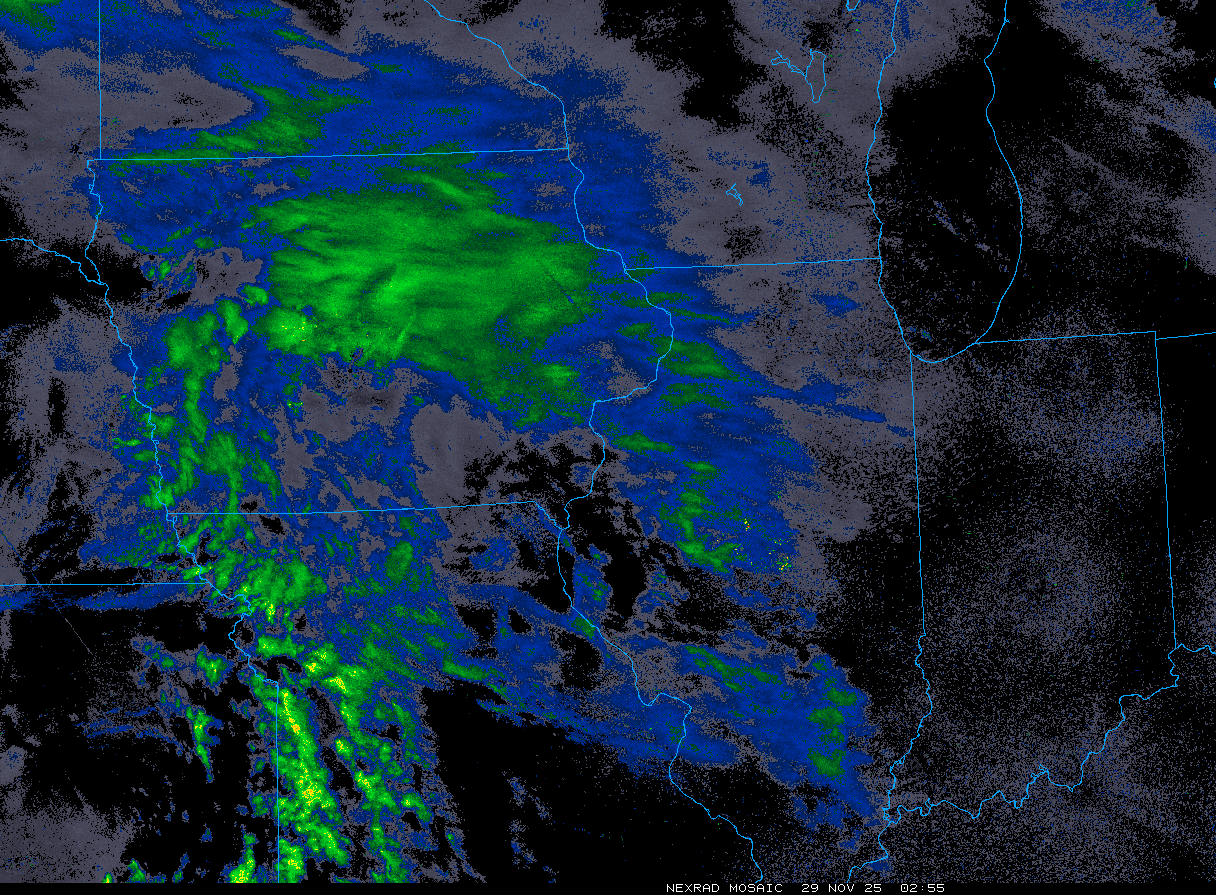
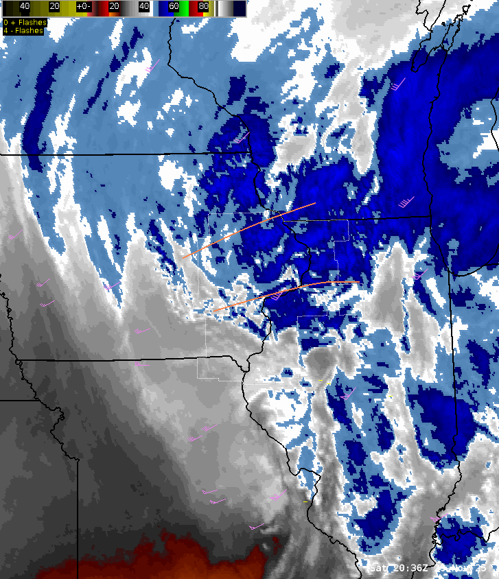
| Figure 1: Satellite water vapor imagery with the zone between the orange lines having been favored for strong lift and persistent banded snow. This positioning, just north of a dry slot and within the system developing "comma-head", is often a ripe zone for heavy precipitation and was indeed the case during the mid-afternoon into early evening on November 29. | Figure 2: November 29, 3 PM Graphicast issued by our office highlighting this zone of heavy snow development. | |
 |
 |
 |
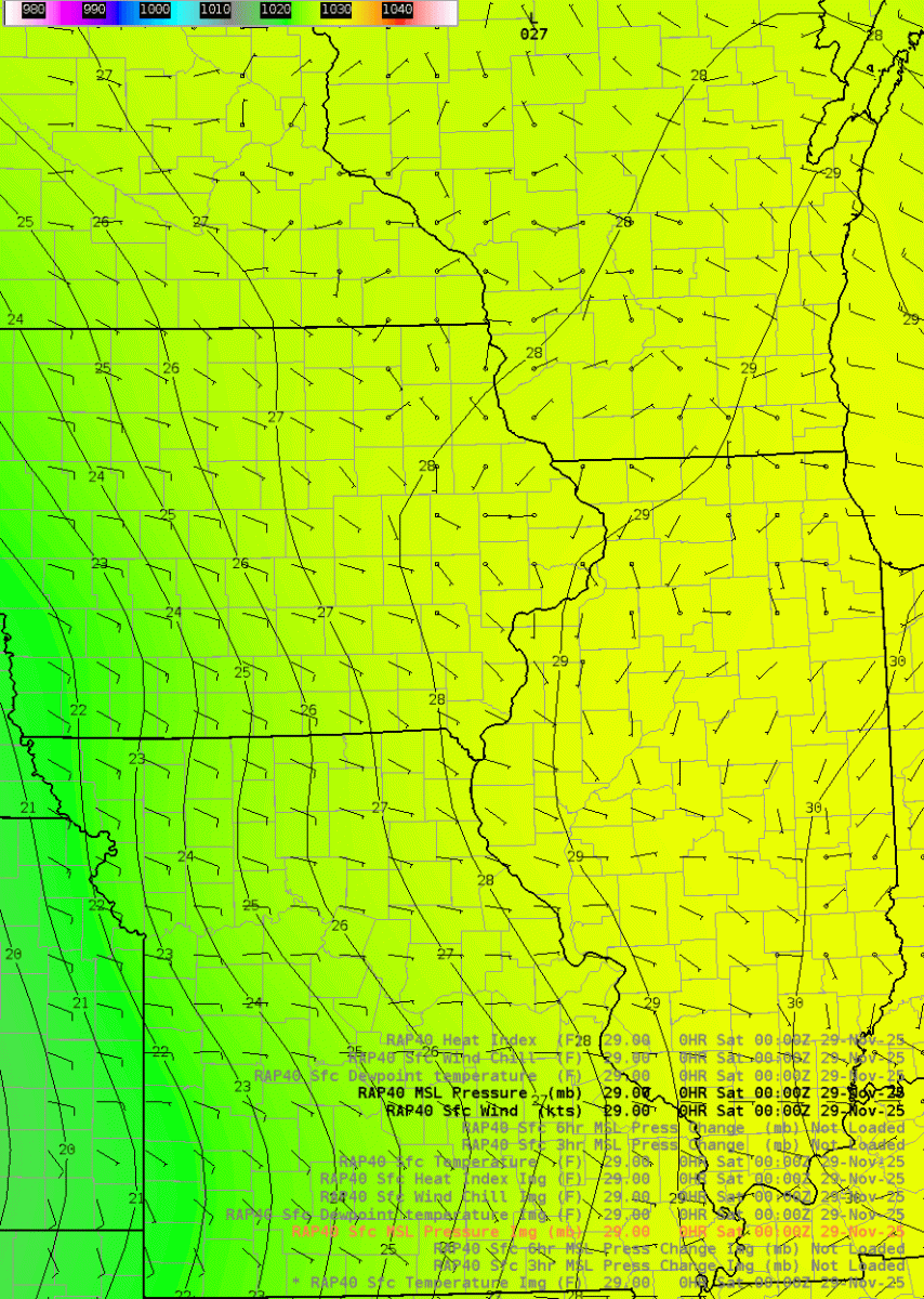
| Figure 3: DVN 18Z (noon CST) weather balloon data referred to as a sounding, showing a deeply saturated profile with high atmospheric moisture (precipitable water greater than one half inch) and steep lapse rates above that within the dendritic growth zone (larger snow flake development). The saturated somewhat isothermal temperature profile between -4C and -8C in the lowest several thousand feet favored the "sticking" of snowflakes to each other (aggregation), helping for larger flake size. | Figure 4: Mean sea level pressure (MSLP) from RAP model analysis. This depicts the surface low pressure passing across our southern area. This is a favorable path for our northern CWA to see large snowfall amounts if the temperature profiles are favorable, which they were. In the southern CWA, there was copious moisture and instability ahead of the low pressure with still a cold enough profile to support heavy snow as well, especially on the morning and early afternoon of November 29. | Figure 5: Dew point from RAP model analysis. This shows the dew points increasing ahead of and within the system, but values still staying for the most part below freezing, which with cooled pavement allowed for quick accumulations and limited melting. |
 |
Media use of NWS Web News Stories is encouraged! Please visit our Events Page for a catalog of more events. |
|