Scattered severe thunderstorms capable of damaging wind gusts and some hail are expected this afternoon and evening from the Upper Ohio River Valley into the Northeast, and from the Appalachians into the Mid-Atlantic States. Excessive rainfall from heavy thunderstorms may produce areas of flash flooding from southern New Mexico into the western and northern Gulf Coast into Wednesday. Read More >
Overview
|
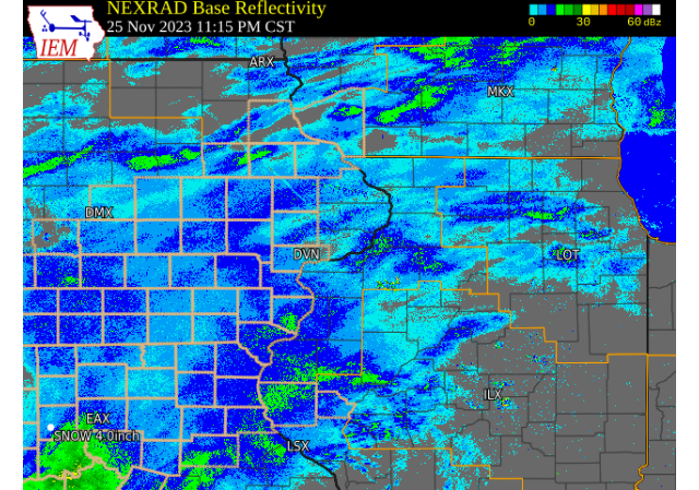
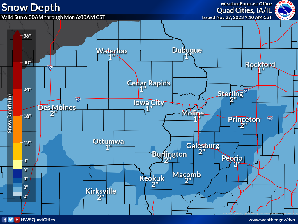
All of eastern Iowa, northwest Illinois and northeast saw the first snow of the season yesterday and today as a robust storm system tracked across the region. Snow primarily fell from Saturday evening through midday Sunday, and tapered off by early Sunday afternoon. While some additional light snow showers fell Sunday afternoon, these provided little in the way of addition impacts or accumulation. Snowfall totals ranged from about 1-3 inches for most, with localized higher amounts around or a little over 4 inches observed in banding that developed across northeast Missouri into eastern Iowa. This lead to snow covered roads and significantly reduced visibility, impacting those traveling from Thanksgiving festivities.
NWS Official Totals Moline: 2.6"
Notable (Non-NWS Official) Totals Lowden, IA: 4.4" (COOP Observer)
|
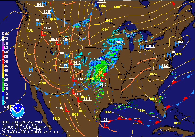 Weather Prediction Center Surface Analysis/Fronts/Radar Loop |
Snowfall Maps (more available Monday AM)
| Storm Total Snowfall Map |
Monday AM Local Snow Depth |
|
 |
 |
Storm Reports
Storm Reports Map - Courtesy IEM
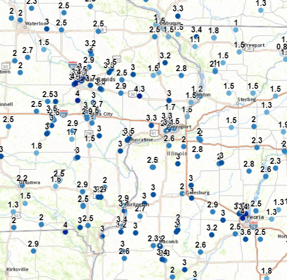 |
Preliminary Local Storm Report...Summary
National Weather Service Quad Cities IA IL
437 PM CST Sun Nov 26 2023

..TIME...   ...EVENT...      ...CITY LOCATION...     ...LAT.LON...
..DATE...   ....MAG....      ..COUNTY LOCATION..ST.. ...SOURCE....
            ..REMARKS..

1230 PM     Snow             Lowden                  41.86N 90.92W
11/26/2023  M4.4 inch        Cedar              IA   CO-OP Observer

            Corrects previous snow report from Lowden.
            Updates the previous snow report from Lowden
            of 4.3 inches. They received another 0.1
            inch to add to the total for the event.

1220 PM     Snow             Dubuque Regional Arpt   42.41N 90.73W
11/26/2023  M2.5 inch        Dubuque            IA   Official NWS Obs

            1.1 inches of the total fell since 6am CST.

1215 PM     Snow             1 SSW Cordova           41.67N 90.33W
11/26/2023  M1.5 inch        Rock Island        IL   Trained Spotter


1210 PM     Snow             1 SSE Washington        41.29N 91.69W
11/26/2023  M3.0 inch        Washington         IA   Public


1201 PM     Snow             1 ESE New London        40.92N 91.40W
11/26/2023  M3.0 inch        Henry              IA   Trained Spotter

            Storm total.

1200 PM     Snow             Davenport Airport       41.61N 90.58W
11/26/2023  M3.3 inch        Scott              IA   Official NWS Obs

            1.4 inches of the total fell since 6 am CST.

1200 PM     Snow             3 E Rozetta             40.95N 90.81W
11/26/2023  E3.0 inch        Henderson          IL   Trained Spotter


1200 PM     Snow             Quad City Airport       41.40N 90.55W
11/26/2023  M2.6 inch        Rock Island        IL   Official NWS Obs

            0.8 inch of the total fell since 6 am CST.

1154 AM     Snow             Parnell                 41.59N 92.01W
11/26/2023  M3.0 inch        Iowa               IA   Public


1154 AM     Snow             4 SSE Loran             42.17N 89.88W
11/26/2023  M1.5 inch        Carroll            IL   Public


1130 AM     Snow             Industry                40.32N 90.61W
11/26/2023  M2.8 inch        McDonough          IL   Trained Spotter


1116 AM     Snow             Wyoming                 42.06N 91.00W
11/26/2023  M3.0 inch        Jones              IA   Trained Spotter


1115 AM     Snow             Dewitt                  41.82N 90.55W
11/26/2023  M3.0 inch        Clinton            IA   Public


1115 AM     Snow             2 NNW Oakland Mills     40.97N 91.63W
11/26/2023  M2.9 inch        Henry              IA   Trained Spotter


1114 AM     Snow             3 N Stockton            42.40N 90.00W
11/26/2023  M1.8 inch        Jo Daviess         IL   CO-OP Observer

            Updated total. Snow becoming lighter.

1100 AM     Snow             2 SSW Williamstown      41.54N 91.75W
11/26/2023  M2.9 inch        Johnson            IA   Public


1100 AM     Snow             1 SW Perlee             41.07N 91.92W
11/26/2023  M2.5 inch        Jefferson          IA   Trained Spotter


1100 AM     Snow             2 E King                42.41N 90.56W
11/26/2023  M1.5 inch        Dubuque            IA   Public


1059 AM     Snow             3 SSW Center Junction   42.07N 91.10W
11/26/2023  M3.3 inch        Jones              IA   Public


1053 AM     Snow             4 NNE Croton            40.63N 91.66W
11/26/2023  M3.0 inch        Lee                IA   Trained Spotter


1050 AM     Snow             3 ENE Charlie Heath Mem 40.59N 91.84W
11/26/2023  M4.0 inch        Clark              MO   Trained Spotter


1035 AM     Snow             Mount Carroll           42.09N 89.98W
11/26/2023  M2.1 inch        Carroll            IL   Public


1030 AM     Snow             1 ENE Mount Vernon      41.93N 91.41W
11/26/2023  M3.5 inch        Linn               IA   Trained Spotter


1030 AM     Snow             Hiawatha                42.05N 91.68W
11/26/2023  M3.0 inch        Linn               IA   Trained Spotter

            Corrects previous snow report of 2.0 inches
            from Hiawatha.

1030 AM     Snow             1 W Bettendorf          41.56N 90.49W
11/26/2023  M2.5 inch        Scott              IA   Trained Spotter


1015 AM     Snow             1 W Industry            40.33N 90.64W
11/26/2023  M3.4 inch        McDonough          IL   Trained Spotter


1010 AM     Snow             1 SW University Heights 41.65N 91.57W
11/26/2023  M2.9 inch        Johnson            IA   Trained Spotter


1005 AM     Snow             Cambridge               41.30N 90.20W
11/26/2023  M2.8 inch        Henry              IL   Trained Spotter


1001 AM     Snow             Walcott                 41.59N 90.77W
11/26/2023  M3.3 inch        Scott              IA   Public


1000 AM     Snow             1 NE Hiawatha           42.05N 91.67W
11/26/2023  M3.0 inch        Linn               IA   Trained Spotter


1000 AM     Snow             2 NNE New Windsor       41.23N 90.44W
11/26/2023  M3.0 inch        Mercer             IL   Public


1000 AM     Snow             4 SW Eleanor            40.94N 90.75W
11/26/2023  M3.0 inch        Warren             IL   Trained Spotter


0954 AM     Snow             Biggsville              40.86N 90.86W
11/26/2023  M3.0 inch        Henderson          IL   Trained Spotter


0939 AM     Snow             1 W Elmira              41.72N 91.44W
11/26/2023  M2.7 inch        Johnson            IA   Trained Spotter


0937 AM     Snow             1 WNW Cou Falls         41.82N 91.69W
11/26/2023  M4.0 inch        Johnson            IA   Public


0935 AM     Snow             Preston                 42.05N 90.40W
11/26/2023  E2.8 inch        Jackson            IA   Public

            So far. Still snowing.

0934 AM     Snow             4 SSE Crawford          40.41N 92.24W
11/26/2023  M2.9 inch        Scotland           MO   Public


0930 AM     Snow             2 W Cedar Rapids        41.98N 91.71W
11/26/2023  M4.1 inch        Linn               IA   Public


0929 AM     Snow             North English           41.51N 92.07W
11/26/2023  M3.0 inch        Iowa               IA   Trained Spotter


0925 AM     Snow             3 SSE Milo              41.16N 89.56W
11/26/2023  M2.8 inch        Bureau             IL   Trained Spotter


0916 AM     Snow             1 ENE Anamosa           42.11N 91.27W
11/26/2023  M3.5 inch        Jones              IA   Public


0915 AM     Snow             1 ENE Nauvoo            40.55N 91.38W
11/26/2023  M3.0 inch        Hancock            IL   Public


0913 AM     Snow             2 N Central City        42.24N 91.52W
11/26/2023  M2.0 inch        Linn               IA   Public


0909 AM     Snow             2 WSW Marion            42.02N 91.63W
11/26/2023  M4.1 inch        Linn               IA   Public


0909 AM     Snow             1 N Williamsburg        41.68N 92.01W
11/26/2023  M3.5 inch        Iowa               IA   Public


0901 AM     Snow             2 N Burlington          40.84N 91.12W
11/26/2023  M2.9 inch        Des Moines         IA   Public


0900 AM     Snow             4 NNE Fairfax           41.98N 91.77W
11/26/2023  M4.0 inch        Linn               IA   Trained Spotter


0900 AM     Snow             1 SE Macomb             40.46N 90.67W
11/26/2023  M3.2 inch        McDonough          IL   Public


0900 AM     Snow             Lomax                   40.68N 91.07W
11/26/2023  M3.0 inch        Henderson          IL   Trained Spotter


0900 AM     Snow             Stanwood                41.89N 91.15W
11/26/2023  M2.9 inch        Cedar              IA   Trained Spotter


0900 AM     Snow             1 ENE North English     41.52N 92.06W
11/26/2023  M2.0 inch        Iowa               IA   CO-OP Observer


0857 AM     Snow             Jesup                   42.48N 92.07W
11/26/2023  M3.0 inch        Buchanan           IA   Public


0850 AM     Snow             Fulton                  41.86N 90.16W
11/26/2023  M2.0 inch        Whiteside          IL   Trained Spotter


0845 AM     Snow             1 WSW New London        40.92N 91.43W
11/26/2023  M3.2 inch        Henry              IA   Trained Spotter


0845 AM     Snow             1 NNE Fairfield         41.02N 91.96W
11/26/2023  M1.6 inch        Jefferson          IA   CO-OP Observer
 |
Media use of NWS Web News Stories is encouraged! Please acknowledge the NWS as the source of any news information accessed from this site. |
|