Scattered severe thunderstorms capable of damaging wind gusts and some hail are expected this afternoon and evening from the Upper Ohio River Valley into the Northeast, and from the Appalachians into the Mid-Atlantic States. Excessive rainfall from heavy thunderstorms may produce areas of flash flooding from southern New Mexico into the western and northern Gulf Coast into Wednesday. Read More >
Storm Overview
|
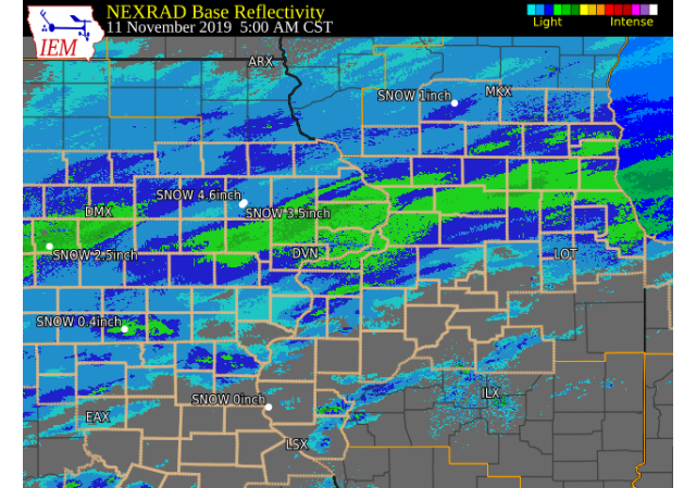
A developing storm system brought widespread light to moderate snow to all of eastern Iowa, northwest Illinois and northeast Missouri on Nov 10-11, 2019. Snow began on the evening of November 10th, and lasted through midday of November 11th before coming to an end by the mid-afternoon. Snowfall totals were mixed across the region, with areas along and north of I-80 in Iowa and Illinois seeing amounts around 4-6 inches. Amounts decreased to the south, with totals of one inch around Burlington, Fort Madison and Keokuk. This was the snowiest Veteran's Day on record for Moline IL and Dubuque IA, surpassing previous highs set back in 1921 and 2013! See below for additional details.
Official National Weather Service Observations Moline: 3.5" (Snowiest Veteran's Day, new amount of 3.5" surpasses 2.4" measured back in 1921) Davenport: 2.8" Dubuque: 4.4" (Snowiest Veteran's Day, new amount of 3.3" surpasses 1.4" measured back in 1921 and 2013)
***Cedar Rapids, Iowa City and Burlington do not measure snow as part of their climate records. Please see the Snowfall Amounts and Storm Reports sections for reported snow amounts in these locations.*** |
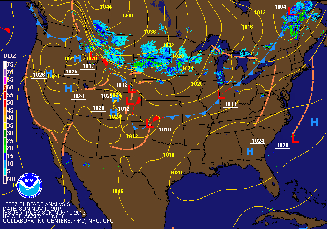 WPC - Surface Map and Radar Loop |
Snowfall Amounts (additional information to be added Wed.)
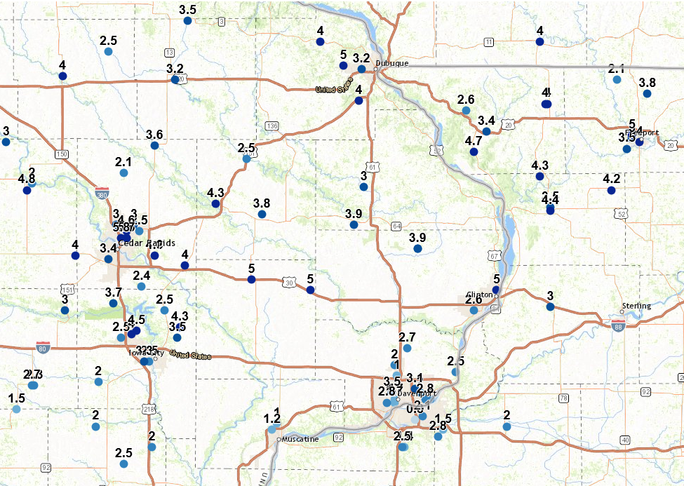
| Local Snowfall Map Nov 11 |
Regional Snowfall Map Nov 11 |
 |
.png) |
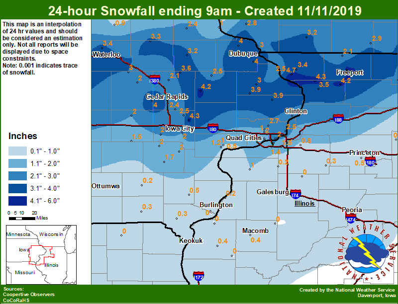
24 hour snow fall in inches,
for eastern Iowa, northwest and west central Illinois,
and northeast Missouri. Reported between Midnight and 9 AM,
Monday November 11, 2019.

....IOWA....
NWS Johnston* 5 NNW               4.4
Iowa City 8.0 NE                  4.3
Anamosa 3 SSW                     4.2
Rickardsville 0.2 W               4.0
Dubuque Arpt                      4.0
Fairfax 4.0 NW                    4.0
Charlotte 1.9 WNW                 3.9
Maquoketa 4 W                     3.9
Coggon                            3.6
Waterloo ASOS 5 NW                3.4
Stanley                           3.3
Manchester                        3.2
Toledo 3 N                        3.0
Dubuque LD11                      3.0
Fulton                            3.0
Mount Auburn 2.2 NNW              3.0
Marshalltown 1 NW                 3.0
Riverdale 0.5 N                   2.8
Park View 0.2 WSW                 2.7
Perry 0 W                         2.7
Camanche 1.2 W                    2.6
Bellevue LD12                     2.5
Le Claire 1.8 NNE                 2.5
Monticello 1 E                    2.5
Solon 0.3 ESE                     2.5
Ely 0.5 SE                        2.4
Elkader 6SSW                      2.4
Central City 6.7 W                2.1
Ames US 30 2 SSE                  2.0
Bettendorf 2.2 SE                 2.0
Eldridge 0.7 SSW                  2.0
Marengo                           2.0
Iowa City                         2.0
Wellman 4.0 E                     2.0
Vinton                            2.0
Kalona 7.3 NNW                    2.0
Ainsworth 7.4 N                   2.0
Pella 4 N                         1.8
Washington                        1.7
Davenport 0.9 WNW                 1.7
Davenport 0.9 SSW                 1.7
North English                     1.5
Muscatine 2.1 N                   1.2
Muscatine 2N                      1.0
Beaconsfield 1 NNE                1.0
Davenport Arpt                    1.0
Fayette 1 NW                      1.0
Hampton 1 N                       1.0
Guttenberg Dam 10                 1.0
Tripoli 0 N                       0.9
New London 1.5 SW                 0.5
Donnellson                        0.3
Keosauqua                         0.3
Centerville 0 NE                  0.2
Fairfield                         0.2
Mason City 1 NNE                  0.1
Cresco 1 NE                       0.0
Burlington 6.5 SSW                0.0
....ILLINOIS....
Freeport 2.0 NW                   5.0
Hanover 0.2 NW                    4.7
Mount Carroll 6.8 NNW             4.3
Freeport                          4.2
Shannon 0.2 S                     4.2
Mount Carroll                     3.5
Freeport 2.9 WSW                  3.5
Elizabeth                         3.4
Roscoe 2SE                        3.1
Freeport 1.7 NW                   3.0
Rockford ASOS                     2.9
Moline 0.7 NNE                    2.1
Winslow 4.3 ESE                   2.1
Mundelein                         2.0
Paw Paw 1 E                       1.5
Coal Valley 2.6 E                 1.5
Quad City Arpt                    1.4
Aledo                             1.0
Rochelle                          1.0
Geneseo 2.0 NW                    0.8
Tiskilwa 2.1 N                    0.5
Ill. City LD16 3 WNW              0.5
Bentley                           0.4
Colchester 3.5 NE                 0.4
Kewanee 1 E                       0.3
Ottawa 4 SW                       0.2
Gladstone LD18                    0.2
New Windsor 2.0 N                 0.2
Romeoville                        0.1
Princeton 1.1 SE                  0.0
Mendota 2 SE                      0.0
Augusta                           0.0
Princeton                         0.0
Minonk                            0.0
Prairie City 2S                   0.0
Altona                            0.0
Windsor                           0.0
Streator 3 SE                     0.0
Ogden                             0.0
Dallas City 3.0 SSE               0.0
Tuscola                           0.0
....MISSOURI....
Memphis                           0.0
Columbia                          0.0
....WISCONSIN....
Delavan-1 W-WWTP 1 W              4.0
Darlington                        3.2
Brodhead 1 SW                     2.9
Lancaster 4WSW                    2.8
Madison-ASOS                      1.3
La Crosse WFO                     0.2
Steuben 4SE 3 NE                  0.0
Viroqua                           0.0
....MINNESOTA....
Grand Meadow                      0.0
Theilman 1SSW                     0.0
Preston                           0.0
|
Storm Reports
Storm Reports Map - Courtesy IEM
|
|
THE SNOW REPORTS BELOW ARE LISTED HIGHEST TO LOWEST.
PLEASE NOTE THAT THESE VALUES MAY NOT BE THE FINAL AMOUNTS RECORDED.


PRELIMINARY LOCAL STORM REPORT...SUMMARY
NATIONAL WEATHER SERVICE QUAD CITIES IA IL
800 PM CST MON NOV 11 2019

..TIME...   ...EVENT...      ...CITY LOCATION...     ...LAT.LON...
..DATE...   ....MAG....      ..COUNTY LOCATION..ST.. ...SOURCE....
            ..REMARKS..

0548 PM     SNOW             1 NE KEOKUK             40.42N 91.39W
11/11/2019  M2.0 INCH        LEE                IA   TRAINED SPOTTER

            EVENT TOTAL.

0500 PM     SNOW             1 N MARION              42.05N 91.59W
11/11/2019  M4.4 INCH        LINN               IA   CO-OP OBSERVER

            EVENT TOTAL.

0500 PM     SNOW             HENNEPIN                41.25N 89.34W
11/11/2019  M1.2 INCH        PUTNAM             IL   CO-OP OBSERVER

            EVENT TOTAL.

0403 PM     SNOW             INDUSTRY                40.33N 90.61W
11/11/2019  M1.5 INCH        MCDONOUGH          IL   TRAINED SPOTTER

            EVENT TOTAL.

0403 PM     SNOW             3 ENE CHARLIE HEATH MEM 40.61N 91.84W
11/11/2019  M1.0 INCH        CLARK              MO   TRAINED SPOTTER

            EVENT TOTAL.

0245 PM     SNOW             CAMANCHE                41.79N 90.26W
11/11/2019  M3.3 INCH        CLINTON            IA   CO-OP OBSERVER

            EVENT TOTAL.

0229 PM     SNOW             MILLEDGEVILLE           41.96N 89.78W
11/11/2019  M4.0 INCH        CARROLL            IL   TRAINED SPOTTER

            EVENT TOTAL.

0224 PM     SNOW             MOUNT CARROLL           42.09N 89.98W
11/11/2019  M4.6 INCH        CARROLL            IL   PUBLIC

            EVENT TOTAL.

0217 PM     SNOW             2 E GRIFFIN             41.24N 90.44W
11/11/2019  M1.4 INCH        HENRY              IL   TRAINED SPOTTER

            EVENT TOTAL.

0216 PM     SNOW             3 N STOCKTON            42.40N 90.00W
11/11/2019  M4.5 INCH        JO DAVIESS         IL   CO-OP OBSERVER

            EVENT TOTAL.

0207 PM     SNOW             WYOMING                 42.06N 91.00W
11/11/2019  M3.5 INCH        JONES              IA   TRAINED SPOTTER

            EVENT TOTAL.

0200 PM     SNOW             1 NNE MOLINE            41.49N 90.48W
11/11/2019  M3.0 INCH        ROCK ISLAND        IL   NWS EMPLOYEE

            ANOTHER 0.9 INCHES SINCE 7 AM, TOTAL OF 3
            INCHES EVEN FOR THE EVENT.

0124 PM     SNOW             3 SW WINNESHIEK         42.32N 89.57W
11/11/2019  E4.5 INCH        STEPHENSON         IL   TRAINED SPOTTER

            EVENT TOTAL.

0102 PM     SNOW             3 NE MUSCATINE          41.46N 91.03W
11/11/2019  M2.8 INCH        MUSCATINE          IA   PUBLIC

            FINAL TOTAL.

1253 PM     SNOW             2 NNW MUSCATINE         41.44N 91.08W
11/11/2019  M1.8 INCH        MUSCATINE          IA   TRAINED SPOTTER


1245 PM     SNOW             1 E CLINTON             41.84N 90.22W
11/11/2019  M3.5 INCH        CLINTON            IA   TRAINED SPOTTER


1229 PM     SNOW             1 SW PERLEE             41.07N 91.91W
11/11/2019  M1.5 INCH        JEFFERSON          IA   TRAINED SPOTTER

            DELAYED REPORT. EVENT TOTAL.

1211 PM     SNOW             1 N BURLINGTON          40.82N 91.13W
11/11/2019  M1.0 INCH        DES MOINES         IA   TRAINED SPOTTER


1201 PM     SNOW             1 ENE BURLINGTON REGION 40.79N 91.11W
11/11/2019  M1.5 INCH        DES MOINES         IA   TRAINED SPOTTER

            STORM TOTAL.

1200 PM     SNOW             DAVENPORT AIRPORT       41.61N 90.58W
11/11/2019  M2.8 INCH        SCOTT              IA   OFFICIAL NWS OBS

            EVENT TOTAL, ADDITIONAL 1.8 INCHES SINCE 6
            AM.

1200 PM     SNOW             DUBUQUE REGIONAL ARPT   42.41N 90.73W
11/11/2019  M4.4 INCH        DUBUQUE            IA   OFFICIAL NWS OBS

            EVENT TOTAL, ADDITIONAL 0.4 INCHES SINCE 6
            AM.

1200 PM     SNOW             MOLINE QUAD-CITY AIRPOR 41.40N 90.55W
11/11/2019  M3.5 INCH        ROCK ISLAND        IL   OFFICIAL NWS OBS

            EVENT TOTAL, ADDITIONAL 2.1 INCHES SINCE 6
            AM.

1100 AM     SNOW             WILLIAMSBURG            41.67N 92.01W
11/11/2019  E3.0 INCH        IOWA               IA   PUBLIC

            RELAYED BY MEDIA.

1057 AM     SNOW             2 S MC CONNELL          42.40N 89.74W
11/11/2019  M5.5 INCH        STEPHENSON         IL   TRAINED SPOTTER

            DELAYED REPORT. TOTAL AS OF 11 AM, WAS STILL
            SNOWING.


&&

$$
|
 |
Media use of NWS Web News Stories is encouraged! Please acknowledge the NWS as the source of any news information accessed from this site. |
|