Scattered severe thunderstorms capable of damaging wind gusts and some hail are expected this afternoon and evening from the Upper Ohio River Valley into the Northeast, and from the Appalachians into the Mid-Atlantic States. Excessive rainfall from heavy thunderstorms may produce areas of flash flooding from southern New Mexico into the western and northern Gulf Coast into Wednesday. Read More >
Overview
|
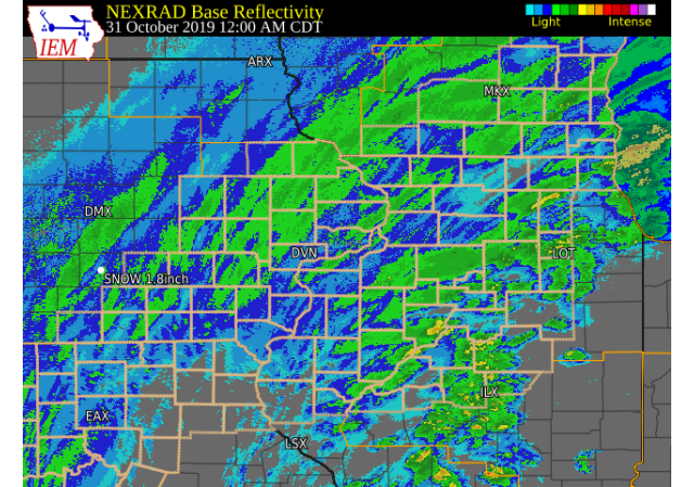
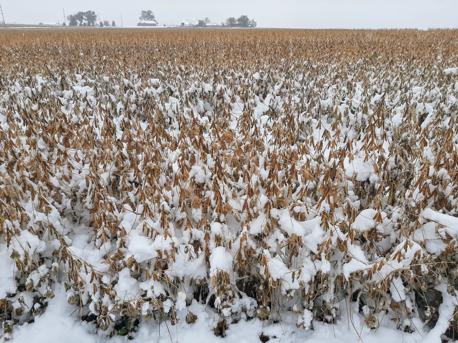
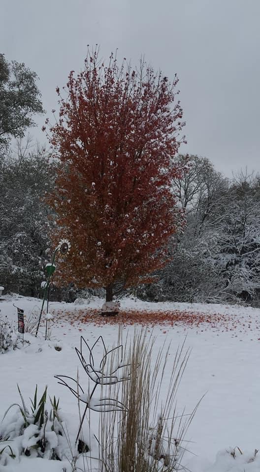
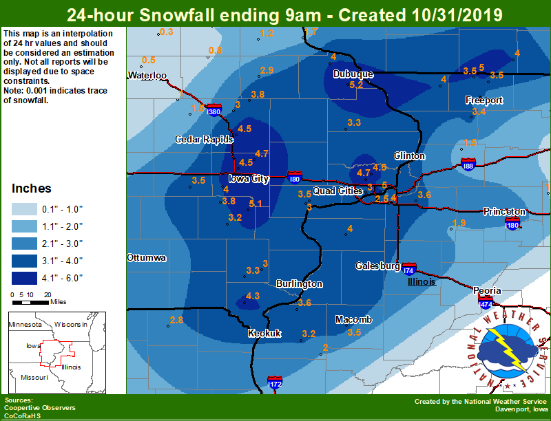
A large upper level storm system tracked across eastern Iowa, northwest Illinois, and northeast Missouri Thursday night and Friday morning. This system brought a long duration snow event to the region, with totals mainly between 2 and 6 inches of snow. This was also the most snow to ever fall on Halloween for much of the forecast area. For more, see our Halloween Climatology Page. Official NWS Obs: Moline: 4.7" Davenport: 4.5" Dubuque: 6.0" |
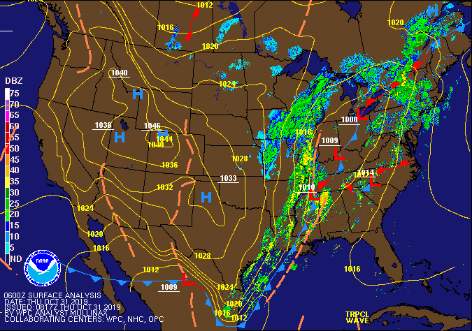 Surface Map 06z 10/31 |
Snow
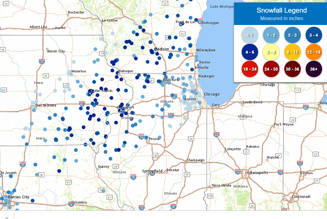
| Local Snowfall Map Oct 31 |
Regional Snowfall Map Oct 31 |
 |
 |
....IOWA....
Dubuque #3 7 SW                   5.2
Ainsworth 7.4 N                   5.1
Riverdale 0.5 N                   5.0
Eldridge 0.7 SSW                  4.7
Solon 0.3 ESE                     4.7
Cedar Rapids 2.7 NE               4.5
Park View 0.2 WSW                 4.5
North Liberty 0.7 SSW             4.5
Donnellson                        4.3
Rickardsville 0.2 W               4.0
Kalona 7.3 NNW                    4.0
Wellman 4.0 E                     3.8
Coggon                            3.8
Muscatine 2N                      3.5
Davenport 0.9 WNW                 3.5
Parnell 0.1 SSW                   3.5
Maquoketa 4 W                     3.3
Salem 3.1 ESE                     3.3
Washington                        3.2
Muscatine 2.1 N                   3.0
Central City 6.7 W                3.0
Davenport 0.9 SSW                 3.0
New London 1.5 SW                 3.0
Manchester                        2.9
Bettendorf 2.2 SE                 2.5
Oskaloosa 1 NNW                   2.4
Centerville 0 NE                  1.8
Guttenberg Dam 10                 1.7
Grinnell 2 SW                     1.5
Vinton                            1.5
Elkader 6SSW                      1.2
Beaconsfield 1 NNE                1.0
Mount Auburn 2.2 NNW              1.0
Fayette 1 NW                      1.0
Stanley                           0.8
Toledo 3 N                        0.5
Waterloo ASOS 5 NW                0.5
NWS Johnston* 5 NNW               0.5
Marshalltown 1 NW                 0.3
Tripoli 0 N                       0.3
Ames US 30 2 SSE                  0.0
Cresco 1 NE                       0.0
Boone 1 SSW                       0.0
Perry 0 W                         0.0
Hampton 1 N                       0.0

....ILLINOIS....
Orangeville 2.8 NW                5.0
Aledo                             4.0
Coal Valley 2.6 E                 4.0
Stockton 3.4 NNE                  4.0
Dallas City 3.0 SSE               3.6
Geneseo 2.0 NW                    3.6
Dakota 4.8 NW                     3.5
Colchester 3.5 NE                 3.5
Winslow 4.3 ESE                   3.5
Shannon 0.2 S                     3.4
Freeport 2.0 NW                   3.3
Bentley                           3.2
Princeton 1.1 SE                  2.9
Princeton                         2.9
Freeport                          2.6
Freeport 2.9 WSW                  2.6
Freeport 1.7 NW                   2.4
Roscoe 2SE                        2.1
Augusta                           2.0
Kewanee 1 E                       1.9
Rockford ASOS                     1.7
Coleta 1.4 SSW                    1.5
Paw Paw 1 E                       1.0
Mendota 2 SE                      1.0
Mundelein                         0.8
Rochelle                          0.5
Romeoville                        0.2
Streator 3 SE                     0.1

....MISSOURI....
Memphis                           2.8
Columbia                          0.4

....WISCONSIN....
Brodhead 1 SW                     4.0
Beloit-College                    3.0
Madison-ASOS                      2.5
Steuben 4SE 3 NE                  1.4
La Crosse WFO                     0.0
|
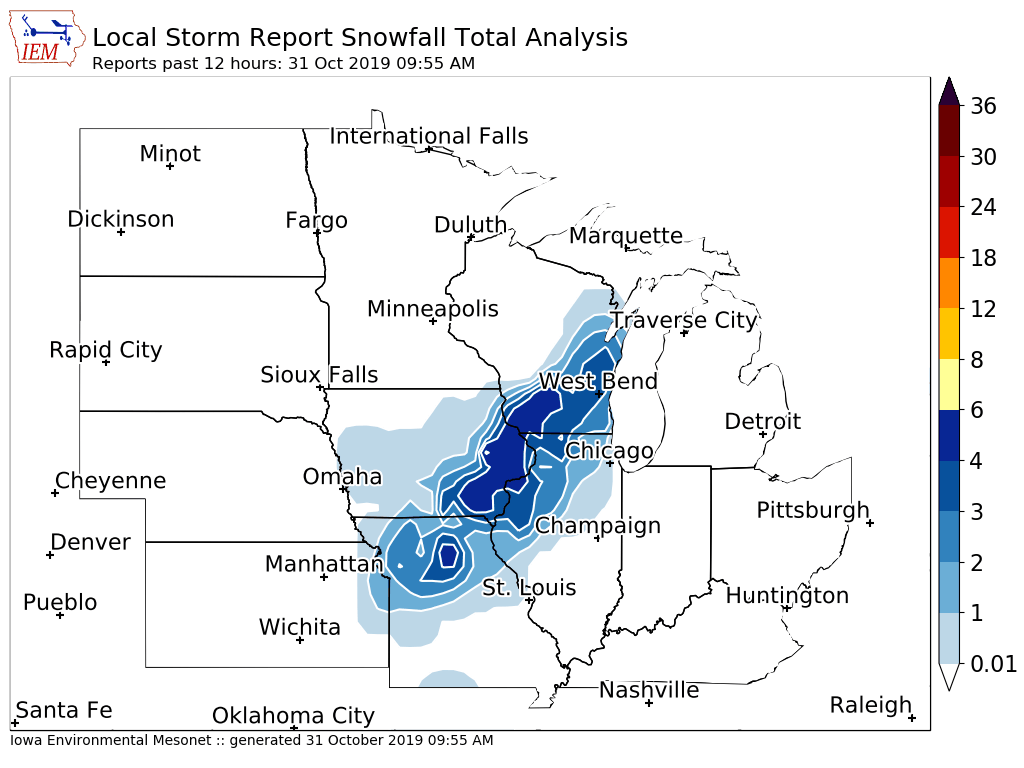
Storm Reports
Storm Reports Map - Courtesy IEM
|
|
PRELIMINARY LOCAL STORM REPORT...SUMMARY
NATIONAL WEATHER SERVICE QUAD CITIES IA IL
1054 AM CDT THU OCT 31 2019

..TIME...   ...EVENT...      ...CITY LOCATION...     ...LAT.LON...
..DATE...   ....MAG....      ..COUNTY LOCATION..ST.. ...SOURCE....
            ..REMARKS..

0850 AM     SNOW             3 NNE CEDAR RAPIDS      42.01N 91.65W
10/31/2019  M5.8 INCH        LINN               IA   TRAINED SPOTTER

            UPDATED STORM TOTAL.

0722 AM     SNOW             LOWDEN                  41.86N 90.92W
10/31/2019  M5.8 INCH        CEDAR              IA   CO-OP OBSERVER


0815 AM     SNOW             AMANA                   41.80N 91.88W
10/31/2019  E5.7 INCH        IOWA               IA   TRAINED SPOTTER


0707 AM     SNOW             DUBUQUE REGIONAL ARPT   42.41N 90.73W
10/31/2019  M5.2 INCH        DUBUQUE            IA   OFFICIAL NWS OBS

            STORM TOTAL SO FAR. 2.7 INCHES SINCE 1 AM.

0700 AM     SNOW             4 N HASKINS             41.40N 91.54W
10/31/2019  M5.1 INCH        WASHINGTON         IA   COCORAHS

            COCORAHS STATION IA-WS-2 AINSWORTH 7.4 N.

0944 AM     SNOW             1 W COU FALLS           41.82N 91.69W
10/31/2019  M5.0 INCH        JOHNSON            IA   TRAINED SPOTTER


0741 AM     SNOW             1 E FREEPORT            42.29N 89.62W
10/31/2019  M5.0 INCH        STEPHENSON         IL   TRAINED SPOTTER

            STILL SNOWING.

0457 AM     SNOW             1 SSW HIAWATHA          42.04N 91.69W
10/31/2019  M5.0 INCH        LINN               IA   TRAINED SPOTTER

            MEASURED ON AN ELEVATED SURFACE.

0608 AM     SNOW             1 SW PERLEE             41.08N 91.91W
10/31/2019  M5.0 INCH        JEFFERSON          IA   TRAINED SPOTTER


0813 AM     SNOW             5 NE WASHINGTON         41.37N 91.65W
10/31/2019  M5.0 INCH        WASHINGTON         IA   PUBLIC


0558 AM     SNOW             ATALISSA                41.57N 91.16W
10/31/2019  M4.9 INCH        MUSCATINE          IA   PUBLIC

            RELAYED BY BROADCAST MEDIA.

0540 AM     SNOW             3 NNE CEDAR RAPIDS      42.01N 91.66W
10/31/2019  E4.8 INCH        LINN               IA   TRAINED SPOTTER


0530 AM     SNOW             3 NNE CEDAR RAPIDS      42.01N 91.66W
10/31/2019  M4.8 INCH        LINN               IA   TRAINED SPOTTER


0921 AM     SNOW             ANAMOSA                 42.11N 91.29W
10/31/2019  M4.7 INCH        JONES              IA   TRAINED SPOTTER


0800 AM     SNOW             1 SSW ELDRIDGE          41.64N 90.59W
10/31/2019  M4.7 INCH        SCOTT              IA   NWS EMPLOYEE


0645 AM     SNOW             SOLON                   41.80N 91.49W
10/31/2019  E4.7 INCH        JOHNSON            IA   TRAINED SPOTTER


0600 AM     SNOW             SOLON                   41.80N 91.49W
10/31/2019  M4.7 INCH        JOHNSON            IA   COCORAHS

            COCORAHS STATION IA-JH-1 SOLON 0.3 ESE.

0817 AM     SNOW             COYNE CENTER            41.40N 90.56W
10/31/2019  E4.5 INCH        ROCK ISLAND        IL   TRAINED SPOTTER


0829 AM     SNOW             HOPKINTON               42.35N 91.25W
10/31/2019  M4.5 INCH        DELAWARE           IA   TRAINED SPOTTER


0700 AM     SNOW             PARK VIEW               41.69N 90.54W
10/31/2019  M4.5 INCH        SCOTT              IA   COCORAHS

            COCORAHS STATION IA-ST-3 PARK VIEW 0.2 WSW.

0833 AM     SNOW             1 N CREDIT ISLAND       41.52N 90.62W
10/31/2019  M4.3 INCH        SCOTT              IA   TRAINED SPOTTER


0700 AM     SNOW             DONNELLSON              40.65N 91.56W
10/31/2019  M4.3 INCH        LEE                IA   CO-OP OBSERVER

            CO-OP OBSERVER STATION DNNI4 DONNELLSON.

0903 AM     SNOW             2 N CREDIT ISLAND       41.53N 90.62W
10/31/2019  M4.2 INCH        SCOTT              IA   TRAINED SPOTTER


0740 AM     SNOW             1 NW DUBUQUE            42.52N 90.70W
10/31/2019  M4.2 INCH        DUBUQUE            IA   TRAINED SPOTTER

            STILL SNOWING.

0800 AM     SNOW             3 NE CEDAR RAPIDS       42.01N 91.64W
10/31/2019  M4.1 INCH        LINN               IA   TRAINED SPOTTER


0644 AM     SNOW             2 SW CENTER JUNCTION    42.09N 91.12W
10/31/2019  M4.1 INCH        JONES              IA   TRAINED SPOTTER


0645 AM     SNOW             MOLINE QUAD-CITY AIRPOR 41.40N 90.55W
10/31/2019  M4.1 INCH        ROCK ISLAND        IL   OFFICIAL NWS OBS

            STORM TOTAL SO FAR. 2.5 INCHES SINCE 1 AM.

0700 AM     SNOW             ALEDO                   41.20N 90.75W
10/31/2019  M4.0 INCH        MERCER             IL   CO-OP OBSERVER

            CO-OP OBSERVER STATION ALEI2 ALEDO.

0818 AM     SNOW             1 N BURLINGTON          40.82N 91.12W
10/31/2019  E4.0 INCH        DES MOINES         IA   PUBLIC


0949 AM     SNOW             CANTRIL                 40.65N 92.07W
10/31/2019  M4.0 INCH        VAN BUREN          IA   TRAINED SPOTTER

            SNOWING LIGHTLY.

0700 AM     SNOW             2 NNW WARNER            41.45N 90.40W
10/31/2019  M4.0 INCH        HENRY              IL   COCORAHS

            COCORAHS STATION IL-HY-15 COAL VALLEY 2.6 E.

0818 AM     SNOW             COLUMBUS JUNCTION       41.28N 91.37W
10/31/2019  E4.0 INCH        LOUISA             IA   TRAINED SPOTTER


0614 AM     SNOW             2 E HIAWATHA            42.05N 91.64W
10/31/2019  M4.0 INCH        LINN               IA   TRAINED SPOTTER


0700 AM     SNOW             2 NNW WILLIAMSTOWN      41.59N 91.75W
10/31/2019  M4.0 INCH        JOHNSON            IA   COCORAHS

            COCORAHS STATION IA-JH-9 KALONA 7.3 NNW.

0929 AM     SNOW             2 E MACOMB              40.47N 90.65W
10/31/2019  U4.0 INCH        MCDONOUGH          IL   TRAINED SPOTTER

            BLOWING SNOW.

0710 AM     SNOW             1 WNW MAQUOKETA         42.07N 90.68W
10/31/2019  E4.0 INCH        JACKSON            IA   TRAINED SPOTTER


0800 AM     SNOW             RICKARDSVILLE           42.58N 90.88W
10/31/2019  M4.0 INCH        DUBUQUE            IA   TRAINED SPOTTER

            STORM TOTAL SO FAR.

0600 AM     SNOW             RICKARDSVILLE           42.58N 90.88W
10/31/2019  M4.0 INCH        DUBUQUE            IA   COCORAHS

            COCORAHS STATION IA-DB-21 RICKARDSVILLE 0.2
            W.

0700 AM     SNOW             2 SW SAINT DONATUS      42.35N 90.57W
10/31/2019  M4.0 INCH        JACKSON            IA   TRAINED SPOTTER

            STORM TOTAL SO FAR.

0700 AM     SNOW             3 N STOCKTON            42.40N 90.00W
10/31/2019  M4.0 INCH        JO DAVIESS         IL   CO-OP OBSERVER

            STORM TOTAL SO FAR.

0642 AM     SNOW             WASHINGTON              41.30N 91.69W
10/31/2019  M4.0 INCH        WASHINGTON         IA   PUBLIC


0600 AM     SNOW             COGGON                  42.28N 91.53W
10/31/2019  M3.8 INCH        LINN               IA   CO-OP OBSERVER

            CO-OP OBSERVER STATION CGGI4 COGGON.

1032 AM     SNOW             MOUNT CARROLL           42.09N 89.98W
10/31/2019  M3.8 INCH        CARROLL            IL   TRAINED SPOTTER


0720 AM     SNOW             MUSCATINE               41.42N 91.07W
10/31/2019  E3.8 INCH        MUSCATINE          IA   PUBLIC


0630 AM     SNOW             3 W RICHMOND            41.46N 91.76W
10/31/2019  M3.8 INCH        WASHINGTON         IA   COCORAHS

            COCORAHS STATION IA-WS-7 WELLMAN 4.0 E.

0600 AM     SNOW             2 NE COLUSA             40.59N 91.15W
10/31/2019  M3.6 INCH        HANCOCK            IL   TRAINED SPOTTER


0500 AM     SNOW             2 NW GENESEO            41.47N 90.18W
10/31/2019  M3.6 INCH        HENRY              IL   COCORAHS

            COCORAHS STATION IL-HY-8 GENESEO 2.0 NW.

0600 AM     SNOW             NORA                    42.46N 89.94W
10/31/2019  M3.6 INCH        JO DAVIESS         IL   TRAINED SPOTTER

            STORM TOTAL SO FAR.

0625 AM     SNOW             2 WSW CEDAR RAPIDS      41.95N 91.71W
10/31/2019  M3.5 INCH        LINN               IA   COCORAHS

            COCORAHS STATION IA-LN-39 CEDAR RAPIDS 2.5
            WSW.

0700 AM     SNOW             3 W MACOMB              40.46N 90.75W
10/31/2019  M3.5 INCH        MCDONOUGH          IL   COCORAHS

            COCORAHS STATION IL-MCD-7 COLCHESTER 3.5 NE.

0600 AM     SNOW             2 W AFOLKEY             42.43N 89.60W
10/31/2019  M3.5 INCH        STEPHENSON         IL   COCORAHS

            COCORAHS STATION IL-SP-23 DAKOTA 4.8 NW.

0700 AM     SNOW             4 NNE MUSCATINE         41.47N 91.05W
10/31/2019  M3.5 INCH        MUSCATINE          IA   CO-OP OBSERVER

            CO-OP OBSERVER STATION MSTI4 2 N MUSCATINE.

0645 AM     SNOW             3 WNW NEW BOSTON        41.19N 91.06W
10/31/2019  E3.5 INCH        MERCER             IL   CO-OP OBSERVER


0743 AM     SNOW             2 SW NEW LONDON         40.91N 91.43W
10/31/2019  M3.5 INCH        HENRY              IA   TRAINED SPOTTER

            STILL SNOWING.

0759 AM     SNOW             1 NE OAKDALE            41.71N 91.59W
10/31/2019  M3.5 INCH        JOHNSON            IA   TRAINED SPOTTER


0840 AM     SNOW             1 NNE PRESTON           42.06N 90.40W
10/31/2019  M3.5 INCH        JACKSON            IA   TRAINED SPOTTER

            STILL SNOWING.

0700 AM     SNOW             3 NNE MC CONNELL        42.47N 89.72W
10/31/2019  M3.5 INCH        STEPHENSON         IL   COCORAHS

            COCORAHS STATION IL-SP-8 WINSLOW 4.3 ESE.

0930 AM     SNOW             3 ENE CHARLIE HEATH MEM 40.61N 91.84W
10/31/2019  M3.3 INCH        CLARK              MO   TRAINED SPOTTER

            STILL SNOWING.

0745 AM     SNOW             2 NW FREEPORT           42.31N 89.66W
10/31/2019  M3.3 INCH        STEPHENSON         IL   COCORAHS

            COCORAHS STATION IL-SP-6 FREEPORT 2.0 NW.

0900 AM     SNOW             OQUAWKA                 40.94N 90.95W
10/31/2019  M3.3 INCH        HENDERSON          IL   TRAINED SPOTTER


0918 AM     SNOW             1 NE TIFFIN             41.72N 91.66W
10/31/2019  M3.1 INCH        JOHNSON            IA   TRAINED SPOTTER


0748 AM     SNOW             1 W BETTENDORF          41.56N 90.49W
10/31/2019  M3.0 INCH        SCOTT              IA   TRAINED SPOTTER


0611 AM     SNOW             2 W BETTENDORF          41.57N 90.51W
10/31/2019  M3.0 INCH        SCOTT              IA   NWS EMPLOYEE


0730 AM     SNOW             2 N BURLINGTON          40.84N 91.12W
10/31/2019  M3.0 INCH        DES MOINES         IA   TRAINED SPOTTER


0845 AM     SNOW             CAMBRIDGE               41.30N 90.20W
10/31/2019  M3.0 INCH        HENRY              IL   TRAINED SPOTTER

            STORM TOTAL SO FAR.

0630 AM     SNOW             1 SSW CORDOVA           41.67N 90.33W
10/31/2019  M3.0 INCH        ROCK ISLAND        IL   TRAINED SPOTTER

            STORM TOTAL SO FAR.

0703 AM     SNOW             DAVENPORT AIRPORT       41.61N 90.58W
10/31/2019  M3.0 INCH        SCOTT              IA   OFFICIAL NWS OBS

            STORM TOTAL SO FAR, SNOWING HEAVY AT TIME OF
            READING.

0748 AM     SNOW             1 W ELMIRA              41.72N 91.44W
10/31/2019  M3.0 INCH        JOHNSON            IA   TRAINED SPOTTER

            SNOW HAS ENDED.

0751 AM     SNOW             1 WSW MT HAMILL         40.74N 91.64W
10/31/2019  M3.0 INCH        LEE                IA   TRAINED SPOTTER

            STILL SNOWING. HEAVY WET SNOW.

0700 AM     SNOW             2 N MUSCATINE           41.45N 91.07W
10/31/2019  M3.0 INCH        MUSCATINE          IA   COCORAHS

            COCORAHS STATION IA-MC-13 MUSCATINE 2.1 N.

0730 AM     SNOW             1 ESE NEW LONDON        40.92N 91.40W
10/31/2019  M3.0 INCH        HENRY              IA   TRAINED SPOTTER

            UPDATED STORM TOTAL.

0700 AM     SNOW             1 SW NEW LONDON         40.91N 91.43W
10/31/2019  M3.0 INCH        HENRY              IA   COCORAHS

            COCORAHS STATION IA-HY-1 NEW LONDON 1.5 SW.

0745 AM     SNOW             2 SW GALVA              41.15N 90.06W
10/31/2019  M2.9 INCH        HENRY              IL   TRAINED SPOTTER

            STILL SNOWING.

0700 AM     SNOW             1 SSE MANCHESTER        42.47N 91.45W
10/31/2019  M2.9 INCH        DELAWARE           IA   CO-OP OBSERVER

            CO-OP OBSERVER STATION MHRI4 MANCHESTER.

0700 AM     SNOW             1 SE PRINCETON          41.37N 89.45W
10/31/2019  M2.9 INCH        BUREAU             IL   COCORAHS

            COCORAHS STATION IL-BU-5 PRINCETON 1.1 SE.

0600 AM     SNOW             1 WSW MEMPHIS           40.46N 92.18W
10/31/2019  M2.8 INCH        SCOTLAND           MO   CO-OP OBSERVER

            CO-OP OBSERVER STATION MMPM7 MEMPHIS.

0623 AM     SNOW             1 ESE NEW LONDON        40.92N 91.40W
10/31/2019  E2.8 INCH        HENRY              IA   TRAINED SPOTTER


0522 AM     SNOW             1 N GENESEO             41.46N 90.15W
10/31/2019  M2.5 INCH        HENRY              IL   TRAINED SPOTTER


0534 AM     SNOW             AUGUSTA                 40.23N 90.95W
10/31/2019  M2.0 INCH        HANCOCK            IL   CO-OP OBSERVER

            CO-OP OBSERVER STATION AUGI2 AUGUSTA.

0800 AM     SNOW             CARTHAGE                40.41N 91.13W
10/31/2019  M2.0 INCH        HANCOCK            IL   TRAINED SPOTTER


0700 AM     SNOW             1 E KEWANEE             41.24N 89.90W
10/31/2019  M1.9 INCH        HENRY              IL   CO-OP OBSERVER

            CO-OP OBSERVER STATION KEWI2 KEWANEE 1 E.

0700 AM     SNOW             1 SSW COLETA            41.89N 89.81W
10/31/2019  M1.5 INCH        WHITESIDE          IL   COCORAHS

            COCORAHS STATION IL-WD-8 COLETA 1.4 SSW.

0700 AM     SNOW             1 ENE VINTON            42.17N 92.01W
10/31/2019  M1.5 INCH        BENTON             IA   CO-OP OBSERVER

            CO-OP OBSERVER STATION VNTI4 VINTON.

0517 AM     SNOW             BELLE PLAINE            41.90N 92.28W
10/31/2019  E1.0 INCH        BENTON             IA   TRAINED SPOTTER

            STORM TOTAL.

0600 AM     SNOW             2 NNW MOUNT AUBURN      42.29N 92.11W
10/31/2019  M1.0 INCH        BENTON             IA   COCORAHS

            COCORAHS STATION IA-BT-11 MOUNT AUBURN 2.2
            NNW.
 |
Media use of NWS Web News Stories is encouraged! Please acknowledge the NWS as the source of any news information accessed from this site. |
|