Severe thunderstorms, with a significant wind threat, will continue through tonight across the northern Plains. Wind gusts of 60 to 100 mph are possible. Heavy rainfall will continue through tonight from Oklahoma into Missouri, and in the Tennessee Valley through Monday. Critical fire weather conditions continue in the Southwest through Tuesday. Read More >
Overview
|
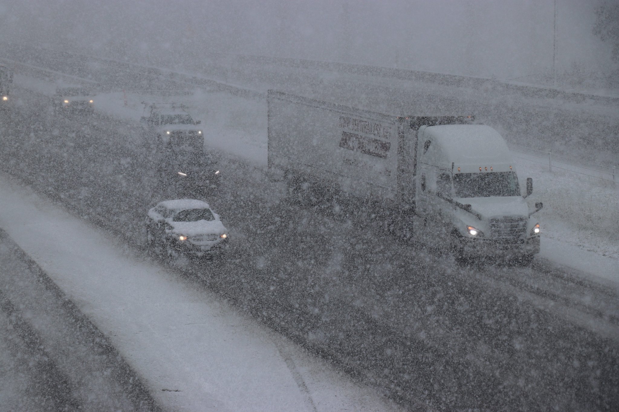
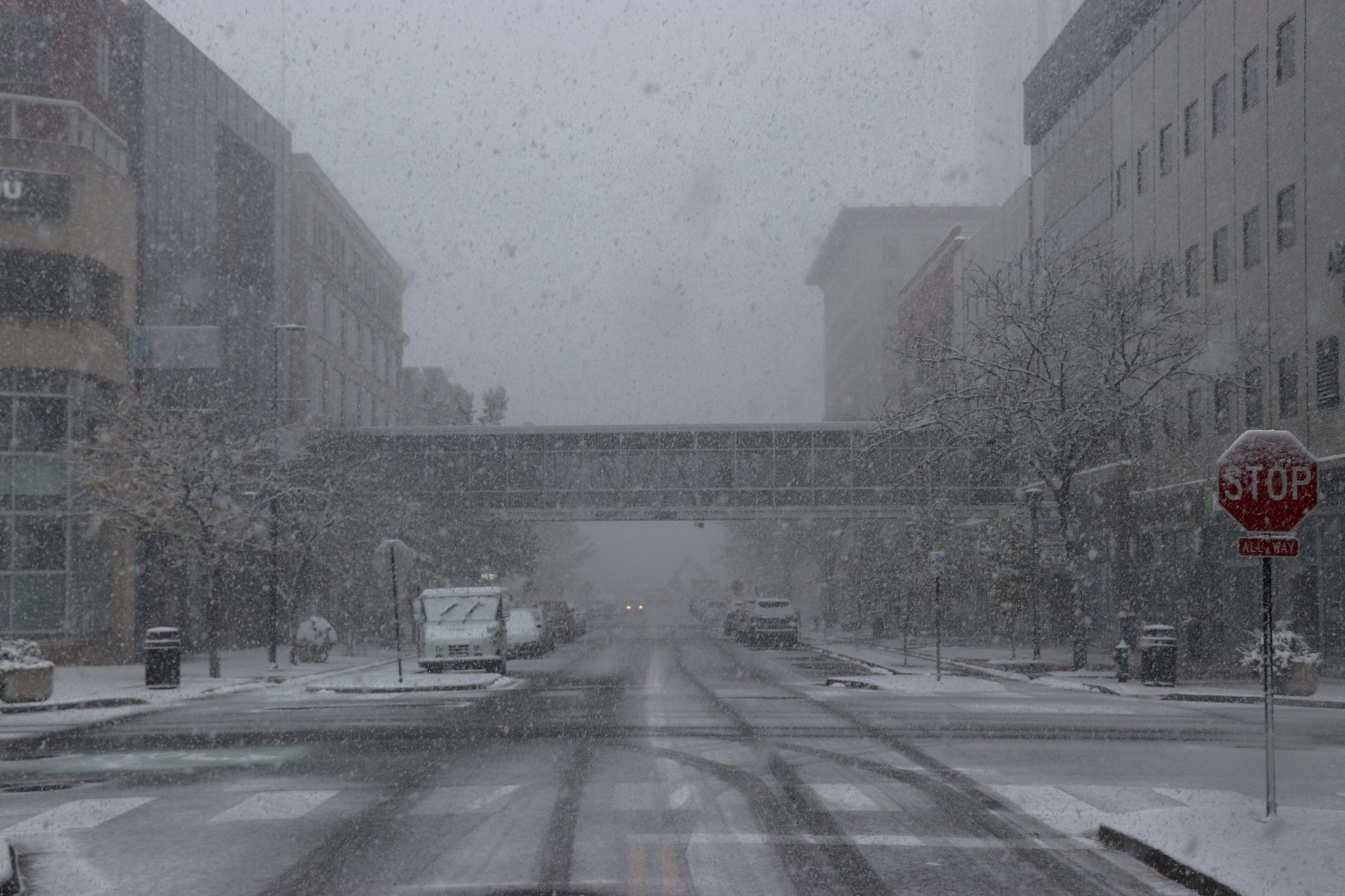
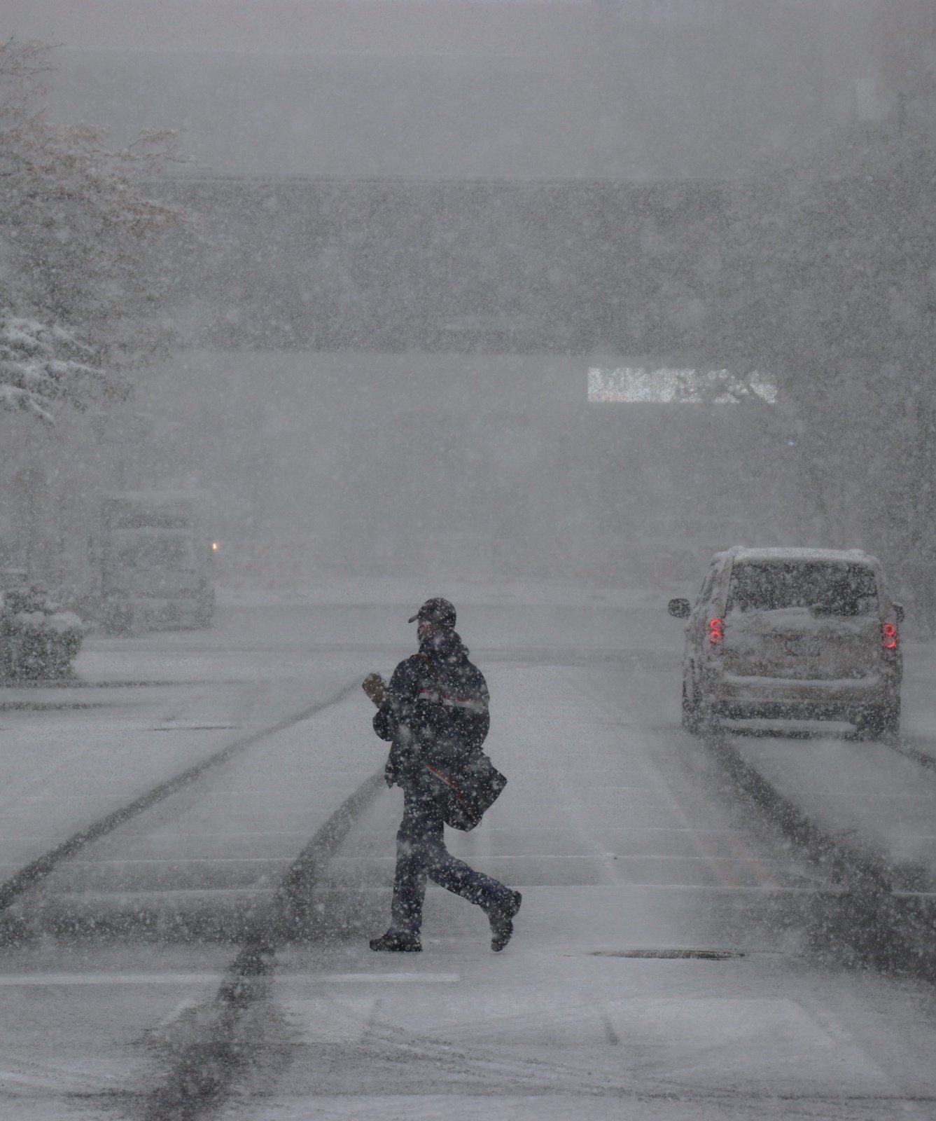
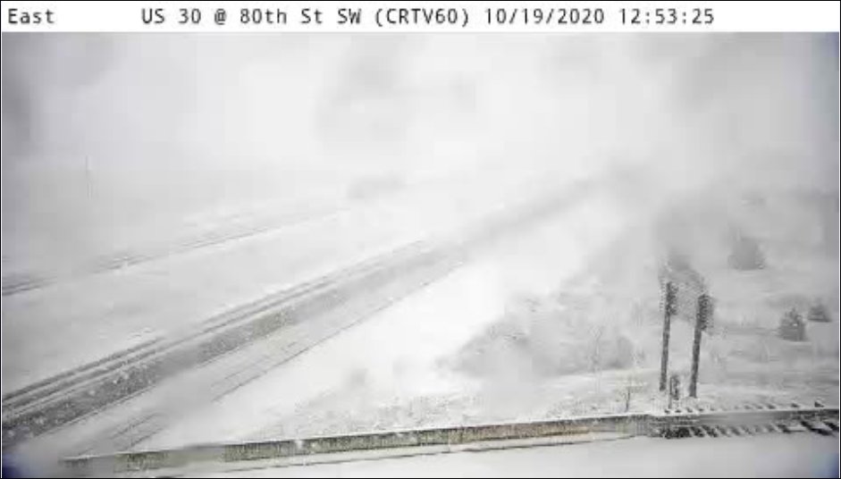
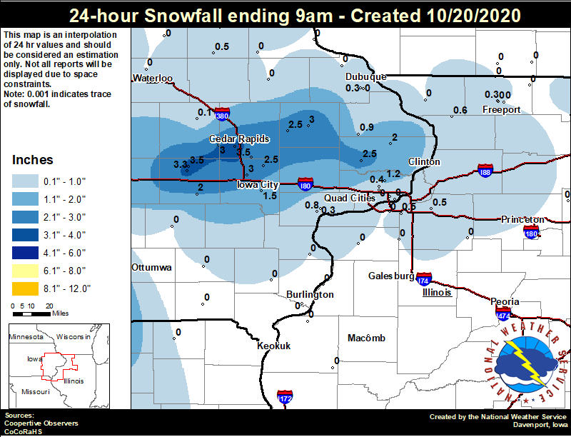
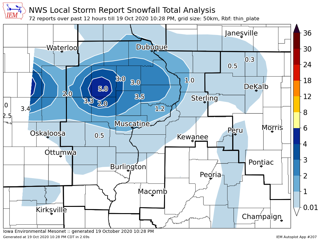
A quick moving intense band of snowfall tracked across Iowa Monday, bringing the first accumulating snow of the season to areas along and north of I-80. Snowfall amounts mainly between 2-4 inches fell in a line from Des Moines, to Belle Plaine, to Cedar Rapids, to Anamosa. Elevated surfaces received more snow than on the grass. Snow moved out of the area by 4:30 pm and started melting quickly. Official NWS Obs: Moline: 0.3" Davenport: 0.2" Dubuque: 0.3" |
|
Snow
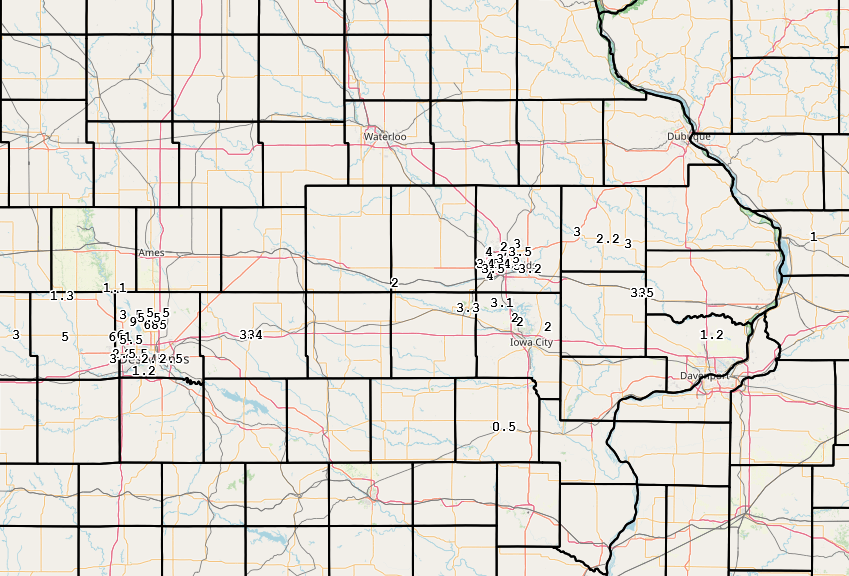
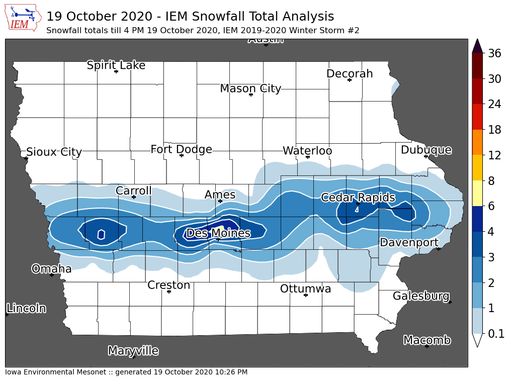
| Local Snowfall Map | Regional Snowfall Map |
Eastern Iowa Snowfall Analysis |
|
|
 |
 |
24 hour snow fall in inches, for eastern Iowa, northwest and west central Illinois, and northeast Missouri. Reported between 6 AM and 9 AM, Tuesday October 20, 2020. ....IOWA.... NWS Johnston* 5 NNW 9.0 Cedar Rapids 2.5 WSW 3.5 Marengo 3.5 Marengo 2.6 SSW 3.3 Center Junction 2.6 W 3.0 North Liberty 0.7 SSW 3.0 Fairfax 4.0 NW 3.0 Anamosa 3 SSW 2.5 Calamus 2.0 NE 2.5 Solon 0.3 ESE 2.5 Ely 0.5 SE 2.2 Charlotte 1.9 WNW 2.0 Parnell 0.1 SSW 2.0 Newton 1 NE 1.8 Iowa City 1.5 Park View 0.2 WSW 1.2 Maquoketa 0.9 Muscatine 2.1 N 0.8 Boone 1 SSW 0.8 Oelwein 1E 0.5 Eldridge 0.7 SSW 0.4 Muscatine 2N 0.3 Dubuque #3 7 SW 0.3 Bettendorf 1.6 W 0.1 Vinton 0.1 Fayette 1 NW 0.1 Hampton 1 N 0.1 Manchester 0.0 Rickardsville 0.2 W 0.0 Wapello 5.4 SE 0.0 Riverdale 0.5 N 0.0 Tripoli 0 N 0.0 Perry 0 W 0.0 Strawberry Point 0.0 Waterloo ASOS 0.0 Sigourney 0.0 Ames US 30 2 SSE 0.0 Burlington 6.5 SSW 0.0 Mason City 1 NNE 0.0 New London 1.5 SW 0.0 Davenport Arpt 0.0 Oskaloosa 1 NNW 0.0 Dubuque Arpt 0.0 Guttenberg Dam 10 0.0 Keosauqua 0.0 Fairfield 0.0 ....ILLINOIS.... Mount Carroll 6.8 NNW 0.6 Coal Valley 1.9 SE 0.5 Geneseo 2.0 NW 0.5 Freeport 2.0 NW 0.3 Roscoe 2SE 0.3 Aledo 0.0 Rockford ASOS 0.0 Paw Paw 1 E 0.0 Davis 0.5 N 0.0 Steward 0.0 Freeport 0.0 Kewanee 1 E 0.0 Orangeville 2.8 NW 0.0 Freeport 1.7 NW 0.0 New Windsor 2.0 N 0.0 Quad City Arpt 0.0 Mundelein 0.0 Ottawa 4 SW 0.0 Romeoville 0.0 Augusta 0.0 Gladstone LD18 0.0 Mendota 2 SE 0.0 Colchester 3.5 NE 0.0 Dallas City 3.0 SSE 0.0 Macomb 0.0 St Anne 0.0 Elizabeth 0.0 ....MISSOURI.... Memphis 0.0 Columbia 0.0 ....WISCONSIN.... Brodhead 1 SW 0.0 La Crosse WFO 0.0 Steuben 4SE 3 NE 0.0 Monroe 1 W 0.0 Viroqua 0.0 Beloit-College 0.0 Delavan-1 W-WWTP 1 W 0.0 ....MINNESOTA.... Theilman 1SSW 0.0 Preston 0.0 |
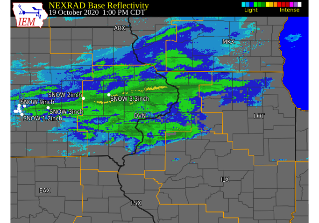
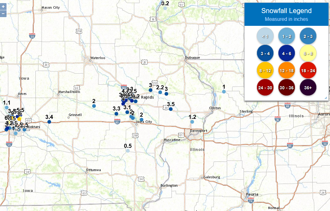
Storm Reports
Storm Reports Map - Courtesy IEM
|
|
 |
PRELIMINARY LOCAL STORM REPORT...SUMMARY
NATIONAL WEATHER SERVICE QUAD CITIES IA IL
440 PM CDT MON OCT 19 2020

..TIME...   ...EVENT...      ...CITY LOCATION...     ...LAT.LON...
..DATE...   ....MAG....      ..COUNTY LOCATION..ST.. ...SOURCE....
            ..REMARKS..

0245 PM     SNOW             3 E CEDAR RAPIDS        41.97N 91.61W
10/19/2020  M5.0 INCH        LINN               IA   BROADCAST MEDIA


0245 PM     SNOW             2 WSW HIAWATHA          42.03N 91.72W
10/19/2020  M4.7 INCH        LINN               IA   TRAINED SPOTTER

            .

0200 PM     HEAVY SNOW       4 NNE FAIRFAX           41.97N 91.75W
10/19/2020  M4.5 INCH        LINN               IA   BROADCAST MEDIA

            .

0300 PM     SNOW             2 W CEDAR RAPIDS        41.98N 91.71W
10/19/2020  M4.4 INCH        LINN               IA   TRAINED SPOTTER

            FINAL STORM TOTAL. LIQUID EQUIVALENT 0.27
            INCHES.

0125 PM     HEAVY SNOW       2 W CEDAR RAPIDS        41.98N 91.71W
10/19/2020  E4.0 INCH        LINN               IA   TRAINED SPOTTER

            .

0115 PM     SNOW             1 ENE FAIRFAX           41.93N 91.76W
10/19/2020  M4.0 INCH        LINN               IA   TRAINED SPOTTER

            UPDATES PREVIOUS SNOW REPORT FROM 1 ENE
            FAIRFAX.

0347 PM     SNOW             3 NE FAIRFAX            41.96N 91.74W
10/19/2020  M3.5 INCH        LINN               IA   TRAINED SPOTTER


0315 PM     SNOW             MARION                  42.03N 91.59W
10/19/2020  M3.5 INCH        LINN               IA   BROADCAST MEDIA

            REPORT RECEIVED VIA SOCIAL MEDIA.

0300 PM     SNOW             2 NNE CEDAR RAPIDS      42.00N 91.66W
10/19/2020  E3.5 INCH        LINN               IA   TRAINED SPOTTER

            SNOWFALL AMOUNT ESTIMATED FROM TOP OF
            VEHICLE.

0256 PM     SNOW             4 N FAIRFAX             41.98N 91.77W
10/19/2020  M3.5 INCH        LINN               IA   TRAINED SPOTTER

            .

0405 PM     SNOW             LOWDEN                  41.86N 90.92W
10/19/2020  M3.5 INCH        CEDAR              IA   CO-OP OBSERVER

            STORM TOTAL - SNOW IS MELTING QUICKLY.

0100 PM     SNOW             2 W CEDAR RAPIDS        41.98N 91.71W
10/19/2020  M3.3 INCH        LINN               IA   TRAINED SPOTTER

            SO FAR. STILL SNOWING HEAVILY.

0153 PM     SNOW             AMANA                   41.80N 91.88W
10/19/2020  M3.3 INCH        IOWA               IA   TRAINED SPOTTER

            3.3 INCHES WET SNOW IN AMANA, IA AT 1:30 PM.
            FELL IN 1 HOUR!.

0350 PM     SNOW             BERTRAM                 41.96N 91.54W
10/19/2020  E3.2 INCH        LINN               IA   TRAINED SPOTTER

            MEASURED ON AN ELEVATED SURFACE. STORM
            TOTAL.

0249 PM     SNOW             1 W COU FALLS           41.82N 91.69W
10/19/2020  M3.1 INCH        JOHNSON            IA   TRAINED SPOTTER

            FINAL SNOWFALL DEPTH FROM TODAYS SNOW EVENT.

0300 PM     SNOW             2 NNW MARION            42.06N 91.61W
10/19/2020  M3.0 INCH        LINN               IA   TRAINED SPOTTER

            SNOW, QUITE HEAVY WITH REDUCED VISIBILITY,
            BEGAN AROUND 11:50AM. THIS IS THE AVERAGE
            MEASUREMENT FROM SEVERAL LOCATIONS.

0400 PM     SNOW             WYOMING                 42.06N 91.00W
10/19/2020  M3.0 INCH        JONES              IA   TRAINED SPOTTER

            .

0305 PM     SNOW             ANAMOSA                 42.11N 91.28W
10/19/2020  M3.0 INCH        JONES              IA   PUBLIC

            LIGHT SNOW CONTINUES.

0226 PM     HEAVY SNOW       2 WSW HIAWATHA          42.03N 91.72W
10/19/2020  M2.7 INCH        LINN               IA   TRAINED SPOTTER

            SNOW HAS ENDED.

0247 PM     SNOW             3 SW CENTER JUNCTION    42.08N 91.11W
10/19/2020  M2.2 INCH        JONES              IA   TRAINED SPOTTER

            HEAVY, WET SNOW TOTAL. A BAD JOKE IN A CRAZY
            YEAR.

0315 PM     SNOW             HIAWATHA                42.05N 91.68W
10/19/2020  M2.0 INCH        LINN               IA   TRAINED SPOTTER

            .

0405 PM     SNOW             1 ESE NORTH LIBERTY     41.74N 91.59W
10/19/2020  M2.0 INCH        JOHNSON            IA   TRAINED SPOTTER

            STORM TOTAL. SNOW HAS ENDED.

0345 PM     SNOW             1 W ELMIRA              41.72N 91.44W
10/19/2020  M2.0 INCH        JOHNSON            IA   TRAINED SPOTTER


0300 PM     SNOW             2 NNW NORTH LIBERTY     41.76N 91.62W
10/19/2020  M2.0 INCH        JOHNSON            IA   TRAINED SPOTTER

            VERY LITTLE ACCUMULATION ON STREETS AND
            SIDEWALKS.

0100 PM     SNOW             BELLE PLAINE            41.90N 92.28W
10/19/2020  M2.0 INCH        BENTON             IA   TRAINED SPOTTER

            SO FAR.

0324 PM     SNOW             PARK VIEW               41.69N 90.54W
10/19/2020  M1.2 INCH        SCOTT              IA   NWS EMPLOYEE

            .

0429 PM     SNOW             MOUNT CARROLL           42.09N 89.98W
10/19/2020  M1.0 INCH        CARROLL            IL   TRAINED SPOTTER

            SNOW BEGAN EARLY AFTERNOON AND PRODUCED A
            LEGITIMATE, CAREFULLY MEASURED 1 INCH ON THE
            GRASSY SURFACES! IT HAS TAPERED OFF TO
            ALMOST NOTHING AS OF 1630 HRS.

0141 PM     SNOW             1 NE WASHINGTON         41.31N 91.68W
10/19/2020  M0.5 INCH        WASHINGTON         IA   PUBLIC

            .


&&

THE REPORTS BELOW ARE SEPARATED INTO SNOW...AND ICE AND SLEET
CATEGORIES...THEN BY AMOUNT...AND ARE NOT NECESSARILY THE
FINAL AMOUNT FOR EACH LOCATION.


SNOW REPORTS LISTED BY AMOUNT

 INCHES  LOCATION                 ST  COUNTY           TIME
 ------  -----------------------  --  --------------   -------
  5.0    3 E CEDAR RAPIDS         IA  LINN             0245 PM
  4.7    2 WSW HIAWATHA           IA  LINN             0245 PM
  4.5    4 NNE FAIRFAX            IA  LINN             0200 PM
  4.4    2 W CEDAR RAPIDS         IA  LINN             0300 PM
  4.0    1 ENE FAIRFAX            IA  LINN             0115 PM
  4.0    2 W CEDAR RAPIDS         IA  LINN             0125 PM
  3.5    LOWDEN                   IA  CEDAR            0405 PM
  3.5    4 N FAIRFAX              IA  LINN             0256 PM
  3.5    2 NNE CEDAR RAPIDS       IA  LINN             0300 PM
  3.5    MARION                   IA  LINN             0315 PM
  3.5    3 NE FAIRFAX             IA  LINN             0347 PM
  3.3    AMANA                    IA  IOWA             0153 PM
  3.3    2 W CEDAR RAPIDS         IA  LINN             0100 PM
  3.2    BERTRAM                  IA  LINN             0350 PM
  3.1    1 W COU FALLS            IA  JOHNSON          0249 PM
  3.0    ANAMOSA                  IA  JONES            0305 PM
  3.0    WYOMING                  IA  JONES            0400 PM
  3.0    2 NNW MARION             IA  LINN             0300 PM
  2.7    2 WSW HIAWATHA           IA  LINN             0226 PM
  2.2    3 SW CENTER JUNCTION     IA  JONES            0247 PM
  2.0    BELLE PLAINE             IA  BENTON           0100 PM
  2.0    2 NNW NORTH LIBERTY      IA  JOHNSON          0300 PM
  2.0    1 W ELMIRA               IA  JOHNSON          0345 PM
  2.0    1 ESE NORTH LIBERTY      IA  JOHNSON          0405 PM
  2.0    HIAWATHA                 IA  LINN             0315 PM
  1.2    PARK VIEW                IA  SCOTT            0324 PM
  1.0    MOUNT CARROLL            IL  CARROLL          0429 PM
  0.5    1 NE WASHINGTON          IA  WASHINGTON       0141 PM
 |
Media use of NWS Web News Stories is encouraged! Please acknowledge the NWS as the source of any news information accessed from this site. |
|