Record setting heat is expected over the next several days from the Intermountain West through the northern Plains. Furthermore, fire weather concerns increase with dry and breezy conditions. Meanwhile, heavy rainfall and severe thunderstorm threats for the Ohio/Tennessee Valleys, central Appalachians and Southeast today. The threat shifts to central Gulf Coast and across central Texas this week. Read More >
Overview
|
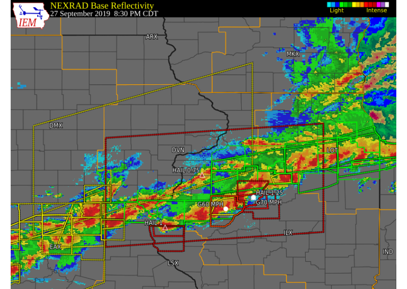
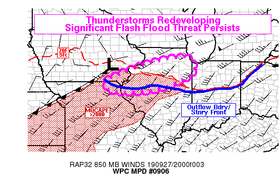
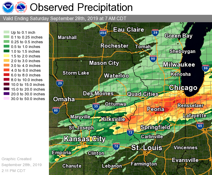
Widespread thunderstorms developed south of a line from Fairfield Iowa to Sterling Rock Falls Friday afternoon and evening. These storms moved eastward across the area throughout the evening and overnight hours. These storms produced heavy rainfall, flashing flooding, and hail up to the size of golf balls. Rain reports south of this line ranged from 1 to 6 inches, with the heaviest rains falling in from Clark County northeastward into Hancock Counties and from Henry County Illinois eastward into Bureau and Putnam Counties. |
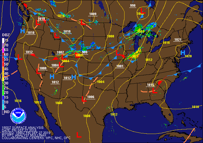 WPC Surface Fronts / Pressure 1 pm 9/27 |
Storm Reports
| Interactive Storm Report Map |
 |
PRELIMINARY LOCAL STORM REPORT...SUMMARY
NATIONAL WEATHER SERVICE QUAD CITIES IA IL
224 PM CDT SAT SEP 28 2019

..TIME...   ...EVENT...      ...CITY LOCATION...     ...LAT.LON...
..DATE...   ....MAG....      ..COUNTY LOCATION..ST.. ...SOURCE....
            ..REMARKS..

0529 PM     HAIL             2 ENE WEVER             40.73N 91.20W
09/27/2019  M1.00 INCH       DES MOINES         IA   TRAINED SPOTTER

            PEA TO QUARTER SIZE HAIL JUST BEGAN.

0529 PM     HAIL             1 S WEVER               40.70N 91.23W
09/27/2019  E1.00 INCH       LEE                IA   LAW ENFORCEMENT

            LOCATION APPROXIMATE. RELAYED BY EMA.

0543 PM     HAIL             BUDA                    41.33N 89.68W
09/27/2019  E1.75 INCH       BUREAU             IL   PUBLIC

            VIA SOCIAL MEDIA, TIME ESTIMATED FROM RADAR.

0545 PM     HAIL             MEMPHIS                 40.46N 92.18W
09/27/2019  E0.75 INCH       SCOTLAND           MO   PUBLIC

            DIME TO PENNY SIZE HAIL.

0550 PM     HAIL             HOPPER                  40.78N 90.97W
09/27/2019  M1.00 INCH       HENDERSON          IL   TRAINED SPOTTER


0550 PM     HAIL             6 S MEMPHIS             40.38N 92.18W
09/27/2019  E0.70 INCH       SCOTLAND           MO   TRAINED SPOTTER

            TIME ESTIMATED FROM RADAR, DELAYED REPORT.

0555 PM     HAIL             5 SSE MEMPHIS           40.39N 92.12W
09/27/2019  E1.00 INCH       SCOTLAND           MO   TRAINED SPOTTER

            1-2 MIN WORTH OF HAIL, TIME ESTIMATED FROM
            RADAR, DELAYED REPORT.

0602 PM     HAIL             2 SE SAINT PAUL         40.74N 91.49W
09/27/2019  E0.88 INCH       LEE                IA   TRAINED SPOTTER

            TIME ESTIMATED FROM RADAR, DELAYED REPORT.

0610 PM     HAIL             1 W LOMBARDVILLE        41.24N 89.66W
09/27/2019  M0.50 INCH       BUREAU             IL   TRAINED SPOTTER


0620 PM     HAIL             3 N PROVIDENCE          41.32N 89.61W
09/27/2019  E0.25 INCH       BUREAU             IL   TRAINED SPOTTER


0633 PM     HAIL             KEWANEE                 41.24N 89.93W
09/27/2019  M0.75 INCH       HENRY              IL   PUBLIC

            VIA FACEBOOK.

0640 PM     HAIL             1 ENE BURLINGTON REGION 40.79N 91.11W
09/27/2019  E0.25 INCH       DES MOINES         IA   PUBLIC

            VIA MPING.

0745 PM     HAIL             PRINCETON               41.38N 89.47W
09/27/2019  M0.25 INCH       BUREAU             IL   CO-OP OBSERVER

            LOTS OF PEA SIZE HAIL - NOT COVERING THE
            GROUND.

0747 PM     HAIL             1 E GOOD HOPE           40.55N 90.65W
09/27/2019  U0.50 INCH       MCDONOUGH          IL   PUBLIC

            REPORT FROM MPING: HALF-INCH (0.50 IN.).

0749 PM     HAIL             1 N GOOD HOPE           40.57N 90.68W
09/27/2019  M0.25 INCH       MCDONOUGH          IL   TRAINED SPOTTER

            PEA SIZE HAIL FROM NORTH OF TOWN AND INTO
            COMMUNITY.

0759 PM     HAIL             3 SW PRAIRIE CITY       40.60N 90.50W
09/27/2019  M0.25 INCH       MCDONOUGH          IL   TRAINED SPOTTER


0801 PM     HAIL             PRAIRIE CITY            40.62N 90.47W
09/27/2019  M0.25 INCH       MCDONOUGH          IL   TRAINED SPOTTER


0809 PM     HAIL             COLCHESTER              40.43N 90.79W
09/27/2019  M0.25 INCH       MCDONOUGH          IL   TRAINED SPOTTER


0809 PM     TSTM WND GST     COLCHESTER              40.43N 90.79W
09/27/2019  E45 MPH          MCDONOUGH          IL   TRAINED SPOTTER

            WIND ESTIMATED 45-50 MPH.

0821 PM     HAIL             2 WNW ALEXIS            41.08N 90.60W
09/27/2019  E0.75 INCH       MERCER             IL   PUBLIC

            QUITE A BIT OF RAIN WITH THIS STORM.

0853 PM     HAIL             AUGUSTA                 40.23N 90.95W
09/27/2019  M1.00 INCH       HANCOCK            IL   TRAINED SPOTTER


0900 PM     HEAVY RAIN       BUSHNELL                40.56N 90.51W
09/27/2019  M0.84 INCH       MCDONOUGH          IL   TRAINED SPOTTER


0905 PM     HEAVY RAIN       1 NE FORT MADISON       40.64N 91.33W
09/27/2019  M1.90 INCH       LEE                IA   TRAINED SPOTTER

            STILL RAINING.

0923 PM     HAIL             2 WSW SAWYER            40.69N 91.39W
09/27/2019  E0.88 INCH       LEE                IA   TRAINED SPOTTER

            PEA TO NICKEL SIZE HAIL.
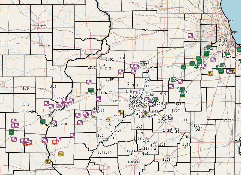
Rain Reports
 |
 |
|
|
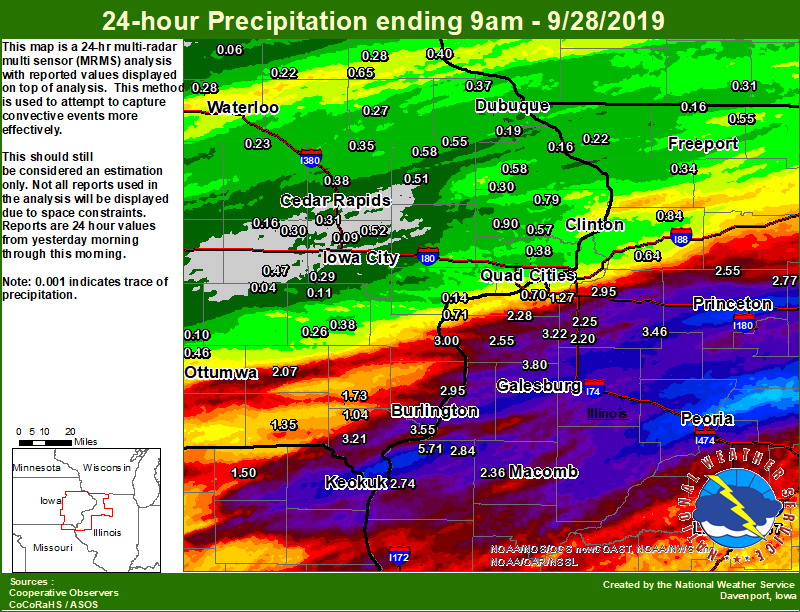
| Figure 1: Local 24-hr Rainfall |
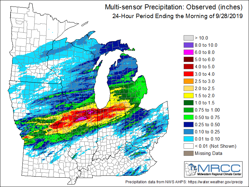
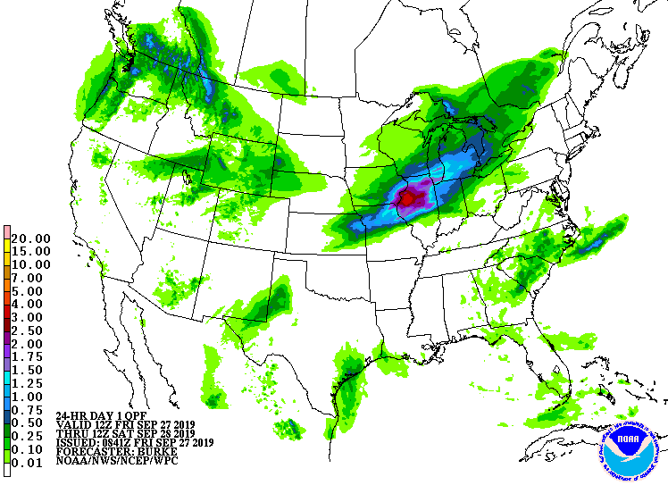
Figure 2: Regional 24-hr Rainfall |
Figure 3: Regional 24-hr Rainfall from Midwest Regional Climate Center |
....IOWA....
Burlington 6.5 SSW               3.55
Donnellson                       3.21
Burlington 0.8 SSE               2.82
Keokuk LD19                      2.74
Burlington Arpt 2 SW             2.57
Rathbun Reservoir 2 N            2.10
Fairfield                        2.07
Salem 3.1 ESE                    1.73
Salem 1S                         1.67
Allerton 2 S                     1.40
Keosauqua                        1.35
New London 1.5 SW                1.27
West Point 7.5 NW                1.04
Centerville 0 NE                 0.96
Calamus 2.0 NE                   0.90
Charlotte 1.9 WNW                0.79
Camanche 1.2 W                   0.65
Strawberry Point                 0.65
Fulton                           0.58
Monticello 1 E                   0.58
De Witt                          0.57
Cascade                          0.55
Davenport 0.9 WNW                0.54
Coralville 1.3 SE                0.53
Solon 0.3 ESE                    0.52
Anamosa 1.9 SE                   0.51
Bettendorf 1.6 WSW               0.51
Anamosa 3 SSW                    0.50
Parnell 0.1 SSW                  0.47
Ottumwa ASOS 6 NNW               0.46
West Branch 2.0 NNW              0.44
Guttenberg Dam 10                0.40
Robins 0.4 SSE                   0.38
Eldridge 0.7 SSW                 0.38
Washington                       0.38
Park View 0.2 WSW                0.38
Rickardsville 0.2 W              0.37
Coggon                           0.35
Toledo 3 N                       0.34
Dubuque LD11                     0.33
Iowa City Arpt                   0.33
Davenport Arpt 5 N               0.31
Cedar Rapids Arpt 5 SW           0.31
Maquoketa 4 W                    0.30
Amana 4.7 W                      0.30
Kalona 7.3 NNW                   0.29
Waterloo ASOS 5 NW               0.28
Elkader 6SSW                     0.28
Manchester                       0.27
Cedar Rapids 2.7 NE              0.26
Washington 5.8 SW                0.26
Marshalltown ASOS 4 N            0.25
Beaconsfield 1 NNE               0.24
Mount Auburn 2.2 NNW             0.23
Oelwein AWOS                     0.22
Dubuque Arpt 7 SW                0.19
Fairfax 4.0 NW                   0.19
Peosta 2.9 E                     0.18
Bellevue LD12                    0.16
Marengo 3.6 N                    0.16
Dubuque #3 7 SW                  0.15
Marshalltown 1 NW                0.12
Wellman 4.0 E                    0.11
NWS Johnston* 5 NNW              0.11
Oskaloosa AWOS 9 ESE             0.10
Pella AWOS 2 WSW                 0.10
North Liberty 0.7 SSW            0.09
Tripoli 0 N                      0.06
Newton 1 NE                      0.05
North English                    0.04

....ILLINOIS....
Princeton 1.1 SE                 5.90
Princeton                        5.90
Dallas City 3.0 SSE              5.71
Romeoville                       4.84
Ottawa 4 SW                      4.40
Joliet                           4.10
Alexis 1 SW                      3.80
St Anne                          3.73
Galesburg Arpt 3 SW              3.66
Peoria ASOS                      3.49
Kewanee 1 E                      3.46
New Windsor 2.0 N                3.22
New Boston LD17                  3.00
Gladstone LD18                   2.95
Geneseo 2.0 NW                   2.95
La Harpe                         2.84
Mendota 2 SE                     2.77
Macomb 3.8 NW                    2.60
Aledo                            2.55
Walnut 5.3 ENE                   2.55
Colchester 3.5 NE                2.36
Milan 8.8 SSW                    2.28
Cambridge 5.9 SW                 2.25
Paw Paw 1 E                      2.24
Andover 4.0 S                    2.20
Fulton LD13                      2.00
Quincy ASOS                      1.84
Bloomington Airport              1.58
Coal Valley 1.9 SE               1.27
Lincoln NWS                      1.17
Rochelle                         1.10
Steward                          1.03
Mundelein                        0.86
Coleta 1.4 SSW                   0.84
Decatur Airport                  0.83
Rochelle AWOS                    0.76
Illinois City 6.7 SW             0.71
Quad City Arpt 3 S               0.70
Moline 0.7 NNE                   0.66
Prophetstown 0.2 SW              0.64
Moline 0.9 N                     0.59
Jacksonville AWOS                0.57
Davis 0.5 N                      0.55
Shannon 0.2 S                    0.34
Freeport 1.7 NW                  0.33
Freeport 2.0 NW                  0.30
Rockford ASOS                    0.24
Elizabeth                        0.22
Roscoe 2SE                       0.20
Freeport                         0.19
Orangeville 2.8 NW               0.16
Freeport 2.9 WSW                 0.14
Ill. City LD16 3 WNW             0.14
....MISSOURI....
Kirksville ASOS                  2.85
Memphis                          1.50
Chillicothe 2 NW                 1.15
Additional Information
The Forecast
 |
 |
||
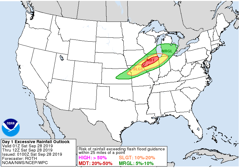
| WPC Day 1 Precipitation Forecast from Valid 9/27 - 9/28 | WPC Day 1 Excessive Rainfall Outlook for 9/27 | ||
 |
Media use of NWS Web News Stories is encouraged! Please acknowledge the NWS as the source of any news information accessed from this site. |
|