Scattered severe thunderstorms capable of damaging wind gusts and some hail are expected this afternoon and evening from the Upper Ohio River Valley into the Northeast, and from the Appalachians into the Mid-Atlantic States. Excessive rainfall from heavy thunderstorms may produce areas of flash flooding from southern New Mexico into the western and northern Gulf Coast into Wednesday. Read More >
Overview
|
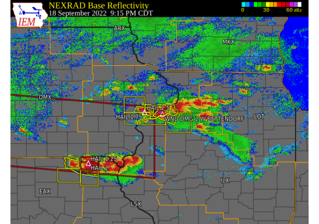
Severe thunderstorms developed across portions of eastern Iowa, northwest Illinois, and far northeast Missouri on the evening of September 18, 2022. Storms initially developed near the Iowa/Missouri border, with one storm near Bloomfield IA producing a well defined wall cloud before weakening. Storms developed, and increased in strength just east of the Cedar Rapids and Iowa City metros as they slowly tracked east around the Interstate 80 corridor. Several large hail reports were received around Durant to south of Tipton, with the highest being 2.5 inches. Storms also produced small hail and wind damage in the Quad Cities before speeding southeast into Henry County.
Additional storms developed along the Iowa/Missouri/Illinois tri-state area, with several tornado warnings issued. Damage was reported in southern Hancock County near Tioga, and continued south into Adams County. Additional information, including surveys, will be available Monday.
|
Surface Analysis (Courtesy of the Weather Prediction Center) |
Storm Reports
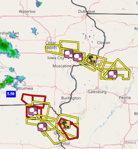
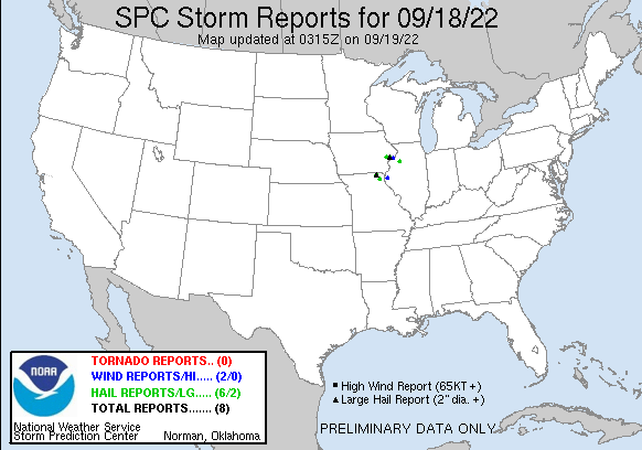
| Interactive Storm Report Map (IEM) | SPC Storm Reports |
 |
 |
..TIME...   ...EVENT...      ...CITY LOCATION...     ...LAT.LON...
..DATE...   ....MAG....      ..COUNTY LOCATION..ST.. ...SOURCE....
            ..REMARKS..

0900 PM     HAIL             MEMPHIS                 40.46N 92.17W
09/18/2022  M2.00 INCH       SCOTLAND           MO   TRAINED SPOTTER


0904 PM     HAIL             MEMPHIS                 40.46N 92.17W
09/18/2022  E1.25 INCH       SCOTLAND           MO   TRAINED SPOTTER


0821 AM     HEAVY RAIN       5 NW INDUSTRY           40.37N 90.67W
09/19/2022  M1.50 INCH       MCDONOUGH          IL   TRAINED SPOTTER


0845 PM     HAIL             KEWANEE                 41.24N 89.93W
09/18/2022  M1.00 INCH       HENRY              IL   BROADCAST MEDIA


0945 PM     FUNNEL CLOUD     2.5 NW TIOGA            40.24N 91.38W
09/18/2022                   HANCOCK            IL   TRAINED SPOTTER

            POSSIBLE TORNADO WITH TREES DOWN 3 MILES
            WEST OF WEST POINT.

1138 PM     HAIL             NAUVOO                  40.55N 91.39W
09/18/2022  E1.00 INCH       HANCOCK            IL   PUBLIC

            CORRECTS PREVIOUS HAIL REPORT FROM NAUVOO.

1031 PM     TSTM WND DMG     3 S MILO                41.16N 89.58W
09/18/2022                   BUREAU             IL   EMERGENCY MNGR

            GRAIN BIN DOWN, UTILITY POLES SNAPPED, AND
            AN OVERTURNED LP TANK NEAR LOCATION.

1031 PM     TSTM WND DMG     3 S MILO                41.16N 89.58W
09/18/2022                   BUREAU             IL   EMERGENCY MNGR

            GRAIN BIN DOWN, UTILITY POLES SNAPPED, AND
            AN OVERTURNED LP TANK NEAR LOCATION.

1032 PM     TSTM WND DMG     1 WSW LONE TREE CORNERS 41.17N 89.50W
09/18/2022                   BUREAU             IL   EMERGENCY MNGR

            GRAIN BIN FELL ON TOP OF ANOTHER LP TANK.

1059 PM     HEAVY RAIN       5 SW PROVIDENCE         41.24N 89.66W
09/18/2022  M1.09 INCH       BUREAU             IL   TRAINED SPOTTER


1250 AM     HAIL             BONAPARTE               40.70N 91.80W
09/19/2022  M1.25 INCH       VAN BUREN          IA   PUBLIC

            VIA SOCIAL MEDIA.

0100 AM     HAIL             FARMINGTON              40.63N 91.74W
09/19/2022  M1.00 INCH       VAN BUREN          IA   TRAINED SPOTTER


0746 AM     HEAVY RAIN       3 ESE KEOSAUQUA         40.72N 91.92W
09/19/2022  M1.00 INCH       VAN BUREN          IA   TRAINED SPOTTER


0906 PM     HAIL             2 SW DAVENPORT MUNICIPA 41.59N 90.62W
09/18/2022  E1.00 INCH       SCOTT              IA   PUBLIC

            PICTURE VIA SOCIAL MEDIA. ESTIMATED TO BE
            QUARTER SIZED.

0922 PM     TSTM WND DMG     2 W BETTENDORF          41.56N 90.51W
09/18/2022                   SCOTT              IA   NWS EMPLOYEE

            3 INCH DIAMETER BRANCH DOWN WITH WIND, TIME
            ESTIMATED FROM RADAR.

0103 AM     HAIL             2 WSW DONNELLSON        40.63N 91.60W
09/19/2022  M1.50 INCH       LEE                IA   TRAINED SPOTTER

            TIME ESTIMATED FROM RADAR.

0125 AM     HAIL             1 SSW MOOAR             40.44N 91.45W
09/19/2022  E2.00 INCH       LEE                IA   TRAINED SPOTTER


0838 PM     HAIL             1 S CEDAR VALLEY        41.71N 91.25W
09/18/2022  E2.00 INCH       CEDAR              IA   PUBLIC

            2.25 INCH HAIL REPORTED, TIME ESTIMATED
            USING RADAR.

0848 PM     TSTM WND DMG     2 N ROCHESTER           41.69N 91.17W
09/18/2022                   CEDAR              IA   PUBLIC

            NUMEROUS REPORTS OF LIMBS DOWN NORTH OF
            ROCHESTER. THE TIME OF THE EVENT WAS
            ESTIMATED USING RADAR.

0850 PM     HAIL             2 E ROCHESTER           41.66N 91.13W
09/18/2022  M2.50 INCH       CEDAR              IA   PUBLIC

            TIME OF THE EVENT ESTIMATED USING RADAR.

0853 PM     HAIL             ROCHESTER               41.67N 91.17W
09/18/2022  M1.00 INCH       CEDAR              IA   EMERGENCY MNGR


0915 PM     HAIL             DURANT                  41.60N 90.91W
09/18/2022  M2.75 INCH       CEDAR              IA   LAW ENFORCEMENT


0915 PM     HAIL             DURANT                  41.60N 90.91W
09/18/2022  M1.75 INCH       CEDAR              IA   PUBLIC


0915 PM     HAIL             DURANT                  41.60N 90.91W
09/18/2022  M2.50 INCH       CEDAR              IA   BROADCAST MEDIA
|
|
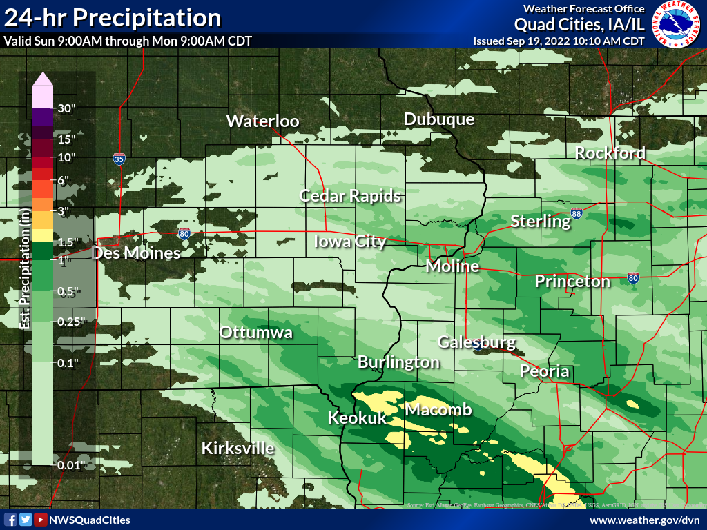
Rainfall Reports
| Local Rainfall Analysis | Regional Rainfall Analysis |
 |
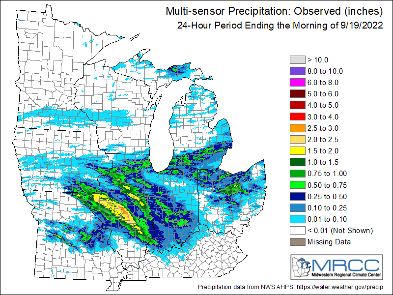 |
24 hour precipitation reports (in Inches), for eastern Iowa, northwest and west central Illinois, and northeast Missouri. Reported between Midnight and 9 AM, Monday September 19, 2022. ....IOWA.... Bettendorf 1.2 WNW 1.46 Keokuk LD19 1.42 West Point 7.5 NW 1.21 Davenport 2.1 N 1.19 Fort Madison 0.9 NE 1.10 Salem 1S 1.10 Keokuk 3.4 NW 1.05 Donnellson 1.02 Burlington Arpt 1.00 Davenport Arpt 0.90 Le Claire LD14 0.88 Burlington 6.5 SSW 0.87 Salem 3.1 ESE 0.85 Davenport 1.0 NE 0.81 Eldridge 0.6 S 0.65 Davenport 0.9 WNW 0.63 Lisbon 0.1 W 0.60 Burlington 0.8 SSE 0.55 New London 1.5 SW 0.54 Fairfield 0.51 Le Claire 1.8 NNE 0.47 Tipton 0.7 N 0.43 Tipton 0.3 ESE 0.35 De Witt 0.35 Yarmouth 1.9 SW 0.32 Park View 0.2 WSW 0.32 Calamus 2.0 NE 0.28 Ottumwa ASOS 6 NNW 0.23 Lowden 0.20 Mt Pleasant 1 SSW 0.19 Camanche 1.2 W 0.16 Solon 0.4 WNW 0.16 Solon 0.3 ESE 0.16 Cedar Rapids 3.3 WNW 0.15 Marion 0.4 NNW 0.13 Sigourney 0.10 Wapello 5.4 SE 0.09 Cedar Rapids Arpt 0.09 Ely 0.5 SE 0.08 Robins 0.8 SE 0.07 Oskaloosa AWOS 9 ESE 0.07 Washington 5.8 SW 0.06 Ainsworth 7.4 N 0.06 North Liberty 1.4 NNE 0.06 Anamosa 3 SSW 0.06 Muscatine 3.0 NE 0.05 Marengo 2.6 SSW 0.05 Marion 1.7 NNW 0.05 Vinton 3.6 SE 0.05 Rathbun Reservoir 2 N 0.05 Parnell 0.1 SSW 0.04 Centerville 0 NE 0.04 Marshalltown ASOS 4 N 0.04 Iowa City 0.04 Williamsburg 0.04 Grinnell 2 SW 0.04 Shellsburg 2.9 S 0.03 Toledo 3 N 0.03 Belle Plaine 0.03 Maquoketa 0.03 Marengo 3.6 N 0.02 Central City 6.7 W 0.02 Fairfax 4.0 NW 0.02 Independence 0.9 WNW 0.02 Monticello 1 E 0.02 Grinnell AWOS 2 SSW 0.02 Wellman 4.0 E 0.01 Charlotte 1.9 WNW 0.01 Perry 0 W 0.01 Ames US 30 2 SSE 0.01 Dubuque Arpt 0.01 Wapello 4.7 N 0.00 Iowa City 2.3 E 0.00 North Liberty 0.7 SSW 0.00 Dubuque 1.4 WNW 0.00 Asbury 0.4 SW 0.00 Independence 0.6 ESE 0.00 Mason City 1 NNE 0.00 Marshalltown 1 NW 0.00 Waukon 4SSE 0.00 Washington 0.00 Iowa City Arpt 0.00 Manchester 0.00 Elkader 6SSW 0.00 Boone 1 SSW 0.00 West Liberty 0.7 NNW 0.00 Mount Auburn 2.2 NNW 0.00 Dubuque 1.0 SE 0.00 Dundee 1.4 NNE 0.00 Oelwein AWOS 0.00 Pella AWOS 2 WSW 0.00 Mason City ASOS 6 W 0.00 Hampton 1 N 0.00 NWS Johnston* 5 NNW 0.00 Waterloo ASOS 5 NW 0.00 Bellevue LD12 0.00 Columbus Jct 2 SSW 0.00 Guttenberg Dam 10 0.00 Fayette 1 NW 0.00 ....ILLINOIS.... Augusta 2.80 Bentley 2.42 Macomb 3.8 NW 2.10 Jacksonville 2E 2.05 Bloomington Airport 1.85 Kewanee 1 E 1.83 Colchester 3.5 NE 1.57 Quincy Arpt 1.46 Dallas City 3.0 SSE 1.23 La Harpe 1.22 Ogden 1.04 Princeton 1.1 SE 0.91 Princeton 0.91 Geneseo 2.0 NW 0.80 St Anne 0.80 Galva 0.9 SE 0.65 Walnut 5.3 ENE 0.63 Moline 0.7 NNE 0.57 Galva 2.7 NE 0.56 Prairie City 2S 0.54 Lincoln NWS 0.50 Mendota 2 SE 0.50 Ottawa 4 SW 0.44 Stronghurst 0.4 SSW 0.43 Coal Valley 2.6 E 0.42 Windsor 0.42 Decatur Airport 0.42 Tuscola 0.38 Quad City Arpt 0.37 Coal Valley 1.9 SE 0.35 Peoria Arpt 0.34 Taylor Ridge 1.1 N 0.30 Rock Falls 3.1 S 0.25 McNabb 1.4 NW 0.22 Gladstone LD18 0.20 Mundelein 0.18 Rockford Arpt 0.15 Fulton LD13 0.13 Alpha 2.3 N 0.07 New Windsor 2.0 N 0.06 Aledo 0.06 Freeport 2.9 WSW 0.05 Romeoville 0.05 Ill. City LD16 3 WNW 0.04 Freeport 0.03 New Boston LD17 0.03 Davis 0.5 N 0.01 Freeport 4.3 W 0.00 Galesburg 0.00 Freeport 1.5 E 0.00 Winslow 4.3 ESE 0.00 Freeport 1.7 NW 0.00 East Dubuque 1.7 SE 0.00 Galena 5.7 E 0.00 Elizabeth 0.00 Mount Carroll 0.00 Joliet Arpt 0.00 Jacksonville Arpt 0.00 Rochelle Arpt 0.00 ....MISSOURI.... Memphis 2.00 Columbia Arpt 0.03 Chillicothe Arpt 0.00 Kirksville Arpt 0.00 ....WISCONSIN.... Darlington 0.02 Brodhead 1 SW 0.00 Steuben 4SE 3 NE 0.00 Prairie du Chien AWOS 0.00 La Crosse WFO 0.00 Viroqua 0.00 Whitewater 0.00 Sullivan-NWS 2 SE 0.00 Beloit-College 0.00 Watertown-Arpt 0.00 Madison Arpt 0.00 Monroe 1 W 0.00 ....MINNESOTA.... Theilman 1SSW 0.00 |
|
Environment
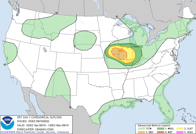
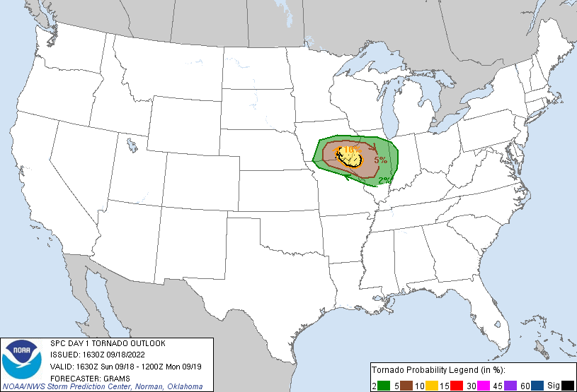
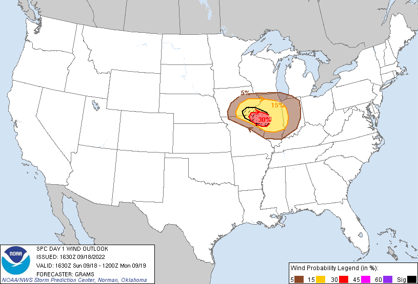
SPC EVENT REVIEW PAGE: 09/18/2022
SPC Categorical/Tornado/Hail/Wind Outlooks
 |
 |
 |
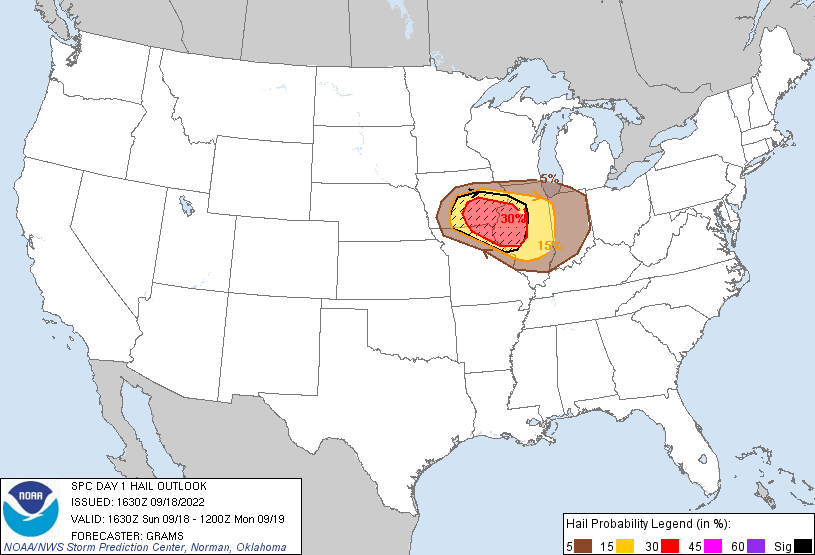 |
| SPC Categorical Outlook | Tornado Outlook | Wind Outlook | Hail Outlook |
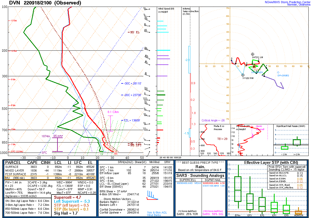
DVN Observed Sounding Analysis
 |
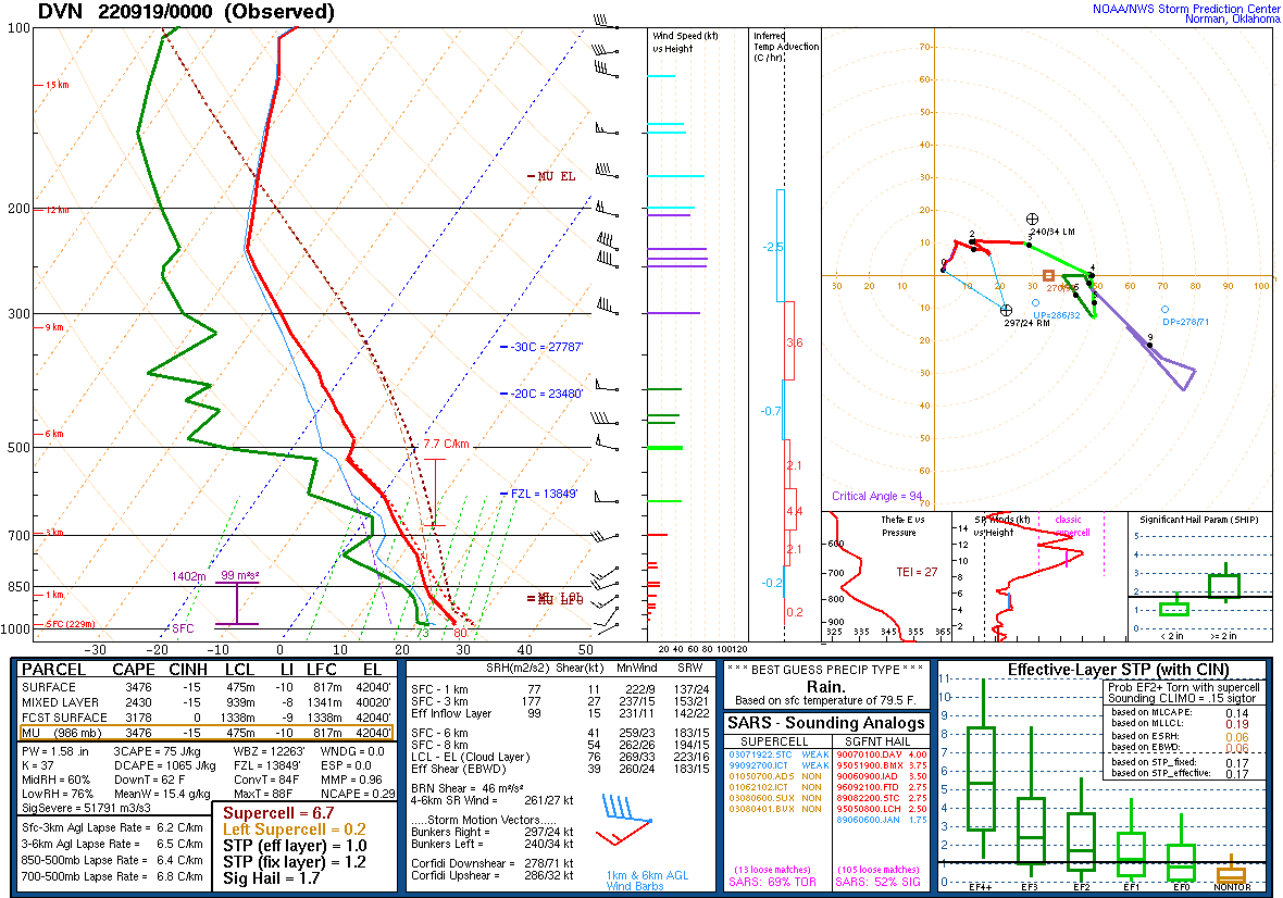 |
| 400 PM DAVENPORT, IA SOUNDING | 700 PM DAVENPORT, IA SOUNDING |
SPC Mesoscale Discussions
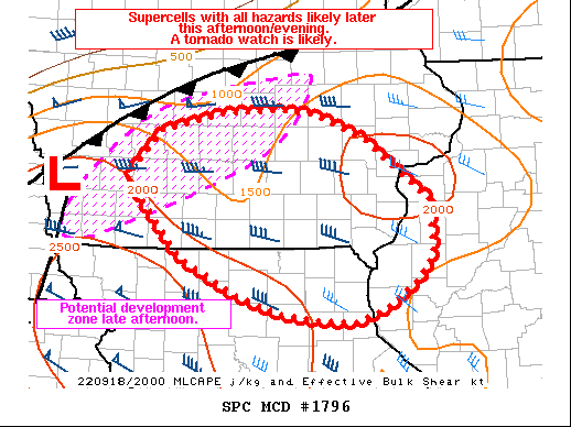 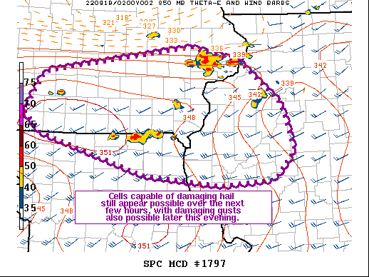 |
| MCD 1796 and 1797 |
SPC Convective Watches
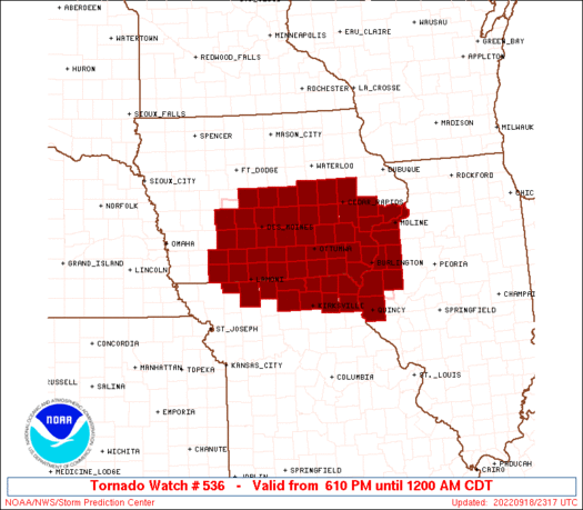 |
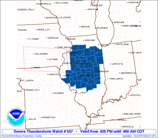 |
| Tornado Watch #536 | Severe Thunderstorm Watch #537 |
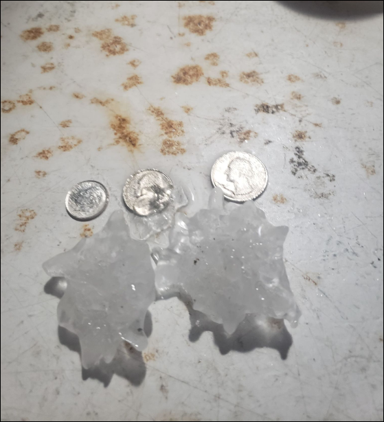
Additional Information
Pictures
 |
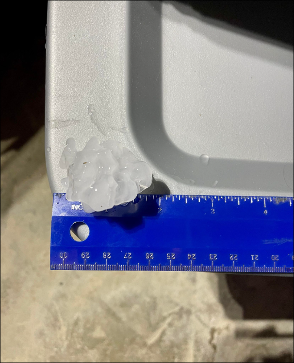 |
||
| Memphis, MO (Courtesy John Gerber) | Keokuk, IA (Courtesy Derek Land) |
 |
Media use of NWS Web News Stories is encouraged! Please acknowledge the NWS as the source of any news information accessed from this site. |
|