Scattered severe thunderstorms capable of damaging wind gusts and some hail are expected this afternoon and evening from the Upper Ohio River Valley into the Northeast, and from the Appalachians into the Mid-Atlantic States. Excessive rainfall from heavy thunderstorms may produce areas of flash flooding from southern New Mexico into the western and northern Gulf Coast into Wednesday. Read More >
Overview
|
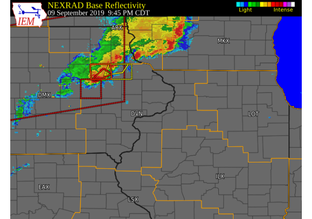
Scattered showers and thunderstorms tracked northeast across central and northeast Iowa Monday evening, bringing 50-60 mph winds, downed trees, and heavy rain to portions of the region. The heaviest rain amounts over 1.50 inches, fell across Buchanan and Delaware counties in Iowa and eastern Jo Daviess and northern Stephenson counties in Illinois. Heavy rain also fell roughly in a line from Tipton, to Maquoketa, to Bellevue, IA. The strongest winds occurred near La Motte, IA where a grain bin collapsed and numerous tree branches fell. |
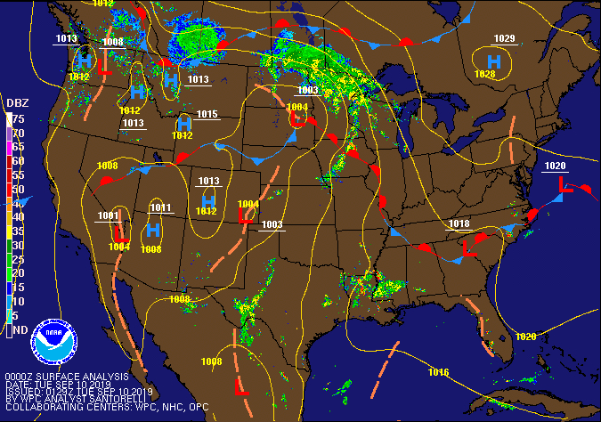 Surface Fronts / Pressure at 7 pm Monday |
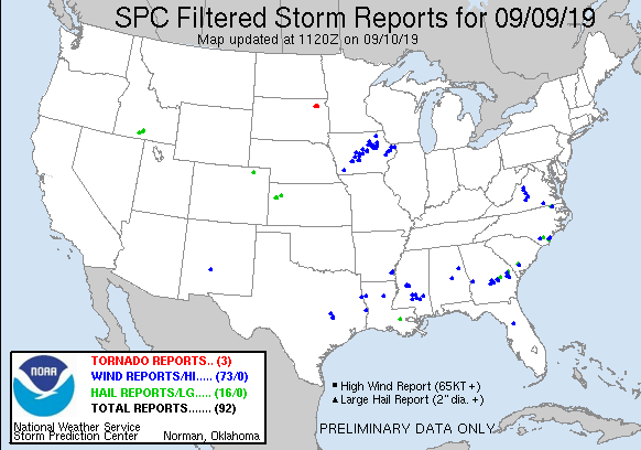
Storm Reports
| Interactive Storm Report Map | SPC Storm Reports |
 |
 |
PRELIMINARY LOCAL STORM REPORT...SUMMARY
NATIONAL WEATHER SERVICE QUAD CITIES IA IL
934 AM CDT TUE SEP 10 2019

..TIME...   ...EVENT...      ...CITY LOCATION...     ...LAT.LON...
..DATE...   ....MAG....      ..COUNTY LOCATION..ST.. ...SOURCE....
            ..REMARKS..

0915 PM     TSTM WND DMG     1 W INDEPENDENCE        42.47N 91.92W
09/09/2019                   BUCHANAN           IA   TRAINED SPOTTER

            SEVERAL SMALL TO MEDIUM SIZE BRANCHES DOWN.

0915 PM     TSTM WND GST     1 W INDEPENDENCE        42.47N 91.92W
09/09/2019  E60 MPH          BUCHANAN           IA   TRAINED SPOTTER


0915 PM     TSTM WND DMG     2 WNW BRANDON           42.33N 92.04W
09/09/2019                   BUCHANAN           IA   LAW ENFORCEMENT

            POWER POLE DOWN. TIME ESTIMATED FROM RADAR.

1200 AM     TSTM WND DMG     TIPTON                  41.77N 91.13W
09/10/2019                   CEDAR              IA   LAW ENFORCEMENT

            LARGE TREE DOWN.

1221 AM     TSTM WND DMG     MAQUOKETA               42.07N 90.67W
09/10/2019                   JACKSON            IA   LAW ENFORCEMENT

            TREE DOWN ON A POWER LINE.

1230 AM     TSTM WND DMG     OXFORD JUNCTION         41.99N 90.95W
09/10/2019                   JONES              IA   LAW ENFORCEMENT

            A FEW BRANCHES AND LIMBS DOWN. TIME
            ESTIMATED FROM RADAR.

0103 AM     TSTM WND GST     1 WNW MAQUOKETA         42.07N 90.68W
09/10/2019  M50 MPH          JACKSON            IA   DEPT OF HIGHWAYS

            IOWA DOT RWIS AT US 61 AND HIGHWAY 64.

0113 AM     TSTM WND GST     1 WNW MAQUOKETA         42.07N 90.68W
09/10/2019  M60 MPH          JACKSON            IA   DEPT OF HIGHWAYS

            IOWA DOT RWIS AT US 61 AND HIGHWAY 64.

0125 AM     TSTM WND DMG     ELIZABETH               42.32N 90.22W
09/10/2019                   JO DAVIESS         IL   LAW ENFORCEMENT

            LARGE TREE DOWN ON HIGHWAY 20.

0200 AM     TSTM WND DMG     LA MOTTE                42.30N 90.62W
09/10/2019                   JACKSON            IA   TRAINED SPOTTER

            CORRECTS PREVIOUS REPORT. GRAIN BIN
            COLLAPSED, MULTIPLE TREES DOWN. TIME
            ESTIMATED FROM RADAR.

0210 AM     TSTM WND GST     3 N STOCKTON            42.40N 90.00W
09/10/2019  M56 MPH          JO DAVIESS         IL   CO-OP OBSERVER


0600 AM     HEAVY RAIN       2 E DUBUQUE             42.50N 90.65W
09/10/2019  M1.74 INCH       DUBUQUE            IA   CO-OP OBSERVER

            CO-OP OBSERVER STATION DBQI4 NO.2-RIVER.

0600 AM     HEAVY RAIN       INDEPENDENCE            42.47N 91.90W
09/10/2019  M2.15 INCH       BUCHANAN           IA   MESONET

            MESONET STATION IDPI4 WAPSIPINICAN RIVER.

0600 AM     HEAVY RAIN       WAUPETON                42.67N 90.88W
09/10/2019  M3.32 INCH       DUBUQUE            IA   MESONET

            MESONET STATION WPNI4 MISSISSIPPI RIVER.

0630 AM     HEAVY RAIN       ELIZABETH               42.32N 90.23W
09/10/2019  M1.71 INCH       JO DAVIESS         IL   CO-OP OBSERVER

            CO-OP OBSERVER STATION EZBI2 ELIZABETH.

0652 AM     HEAVY RAIN       1 NW DUBUQUE            42.52N 90.70W
09/10/2019  M1.69 INCH       DUBUQUE            IA   TRAINED SPOTTER

            OVERNIGHT TOTAL.

0700 AM     HEAVY RAIN       1 WNW INDEPENDENCE      42.47N 91.91W
09/10/2019  M1.50 INCH       BUCHANAN           IA   COCORAHS

            COCORAHS STATION IA-BC-8 INDEPENDENCE 0.9
            WNW.

0700 AM     HEAVY RAIN       BELLEVUE                42.26N 90.42W
09/10/2019  M1.80 INCH       JACKSON            IA   MESONET

            MESONET STATION BLVI4 MISSISSIPPI RIVER.

0700 AM     HEAVY RAIN       1 W MAQUOKETA MUNICIPAL 42.05N 90.75W
09/10/2019  M2.17 INCH       JACKSON            IA   CO-OP OBSERVER

            CO-OP OBSERVER STATION MKTI4 MAQUOKETA.

0700 AM     HEAVY RAIN       2 W AFOLKEY             42.43N 89.60W
09/10/2019  M2.33 INCH       STEPHENSON         IL   COCORAHS

            COCORAHS STATION IL-SP-23 DAKOTA 4.8 NW.

0700 AM     HEAVY RAIN       3 NNE MC CONNELL        42.47N 89.72W
09/10/2019  M2.94 INCH       STEPHENSON         IL   COCORAHS

            COCORAHS STATION IL-SP-8 WINSLOW 4.3 ESE.

0700 AM     HEAVY RAIN       1 NW ONECO              42.50N 89.68W
09/10/2019  M3.55 INCH       STEPHENSON         IL   COCORAHS

            COCORAHS STATION IL-SP-3 ORANGEVILLE 2.8 NW.

0700 AM     HEAVY RAIN       2 ENE DUBUQUE           42.52N 90.65W
09/10/2019  M2.28 INCH       DUBUQUE            IA   MESONET

            MESONET STATION DLDI4 MISSISSIPPI RIVER.

0707 AM     HEAVY RAIN       3 N STOCKTON            42.40N 90.00W
09/10/2019  M2.87 INCH       JO DAVIESS         IL   CO-OP OBSERVER

            24-HR RAINFALL TOTAL, 2.59 INCHES FELL WITH
            EARLY MORNING STORM.

0716 AM     HEAVY RAIN       1 S HAZLETON            42.60N 91.91W
09/10/2019  M1.55 INCH       BUCHANAN           IA   MESONET

            MESONET STATION FW1748 HAZELTON.

0718 AM     HEAVY RAIN       AURORA                  42.62N 91.73W
09/10/2019  M1.75 INCH       BUCHANAN           IA   MESONET

            MESONET STATION FW1481 AURORA.

0840 AM     FLOOD            ORANGEVILLE             42.47N 89.65W
09/10/2019                   STEPHENSON         IL   EMERGENCY MNGR

            RICHLAND CREEK OUT OF ITS BANKS AND
            CONTINUING TO RISE DUE TO RECENT RAIN.

0927 AM     HEAVY RAIN       JESUP                   42.48N 92.07W
09/10/2019  M3.05 INCH       BUCHANAN           IA   PUBLIC
Rain Reports
| Local Rain Map | Regional Rain Map |
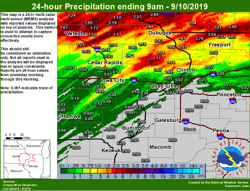 |
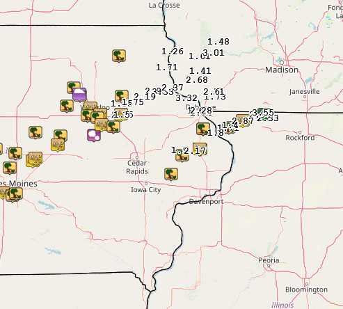
24 hour precipitation reports ....IOWA.... Ames US 30 2 SSE 2.45 Guttenberg Dam 10 2.37 Strawberry Point 2.19 Maquoketa 4 W 2.17 Elkader 6SSW 1.73 Stanley 1.72 Oelwein AWOS 1.69 Waterloo ASOS 5 NW 1.67 De Witt 1.66 Independence 0.9 WNW 1.50 Dubuque LD11 1.50 Rickardsville 0.2 W 1.46 Charlotte 1.9 WNW 1.38 Bellevue LD12 1.37 Manchester 1.37 Fulton 1.34 Tripoli 0 N 1.24 Mount Auburn 2.2 NNW 1.23 Cascade 1.18 Cresco 1 NE 1.15 Peosta 2.9 E 1.15 Fayette 1 NW 1.10 Bellevue 0.3 SSW 1.08 Dubuque Arpt 7 SW 0.93 Calamus 2.0 NE 0.87 Iowa City 8.0 NE 0.85 Monticello 1 E 0.80 Boone 1 SSW 0.78 West Branch 2.0 NNW 0.78 Anamosa 3 SSW 0.77 Cedar Rapids 2.7 NE 0.75 Dubuque #3 7 SW 0.72 Anamosa 1.9 SE 0.71 Wellman 4.0 E 0.69 Iowa City Arpt 0.67 Marion 1.7 NNW 0.63 Marshalltown ASOS 4 N 0.61 Cedar Rapids Arpt 5 SW 0.59 NWS Johnston* 5 NNW 0.59 Fairfax 4.0 NW 0.52 Marengo 3.6 N 0.52 Vinton 0.52 Marshalltown 1 NW 0.45 Iowa City 0.45 Perry 0 W 0.34 Newton 1 NE 0.34 Coggon 0.34 Toledo 3 N 0.33 Central City 6.7 W 0.28 Grinnell 2 SW 0.21 Belle Plaine 0.21 Hampton 1 N 0.20 Parnell 0.1 SSW 0.15 Camanche 1.2 W 0.14 Grinnell AWOS 2 SSW 0.13 Muscatine 2N 0.12 Mason City ASOS 6 W 0.12 Washington 5.8 SW 0.12 Solon 0.3 ESE 0.11 Muscatine 2.1 N 0.10 Sigourney 0.10 Coralville 1.3 SE 0.09 Mason City 1 NNE 0.09 Centerville 0 NE 0.08 Washington 0.08 Ainsworth 7.4 N 0.08 Davenport Arpt 5 N 0.07 Eldridge 0.7 SSW 0.06 Pella 4 N 0.05 Park View 0.2 WSW 0.05 Oskaloosa AWOS 9 ESE 0.03 Kalona 7.3 NNW 0.02 Burlington Arpt 2 SW 0.02 North Liberty 0.7 SSW 0.02 Davenport 0.9 SSW 0.02 Davenport 0.9 WNW 0.02 Le Claire 1.8 NNE 0.02 Riverdale 0.5 N 0.01 Oskaloosa 1 NNW 0.01 Bettendorf 2.2 SE 0.01 Burlington 6.5 SSW 0.01 |
....ILLINOIS.... Orangeville 2.8 NW 3.55 Winslow 4.3 ESE 2.94 Stockton 3.4 NNE 2.70 Dakota 4.8 NW 2.33 Galena 2.22 Galena 5.7 E 1.81 Elizabeth 1.71 Hanover 0.2 NW 1.21 Freeport 2.9 WSW 1.10 Davis 0.5 N 1.03 Freeport 1.7 ESE 0.88 Fulton LD13 0.79 Rockford ASOS 0.74 Freeport 0.69 Freeport 1.7 NW 0.69 Freeport 2.0 NW 0.68 Mundelein 0.56 Ill. City LD16 3 WNW 0.38 Shannon 0.2 S 0.36 Coleta 1.4 SSW 0.27 Walnut 5.3 ENE 0.27 Prophetstown 0.2 SW 0.25 Steward 0.21 Paw Paw 1 E 0.07 Geneseo 2.0 NW 0.06 Rock Falls 0.06 Rochelle 0.06 Joliet 0.05 Romeoville 0.03 Moline 0.7 NNE 0.03 New Boston LD17 0.03 Mendota 2 SE 0.02 Moline 0.9 N 0.01 Quad City Arpt 3 S 0.01 Rochelle AWOS 0.01 St Anne 0.01 Coal Valley 1.9 SE 0.01 |
....WISCONSIN.... Brodhead 1 SW 2.99 Lancaster 4WSW 2.80 Monroe 1 W 2.31 Delavan-1 W-WWTP 1 W 2.20 Beloit-College 2.05 Steuben 4SE 3 NE 1.50 Darlington 1.34 Madison-ASOS 1.16 Viroqua 1.03 Allenton-WWTP .6 NW 0.99 La Crosse WFO 0.90 |
Environment
SPC EVENT REVIEW PAGE: 09/09/2019
 |
 |
 |
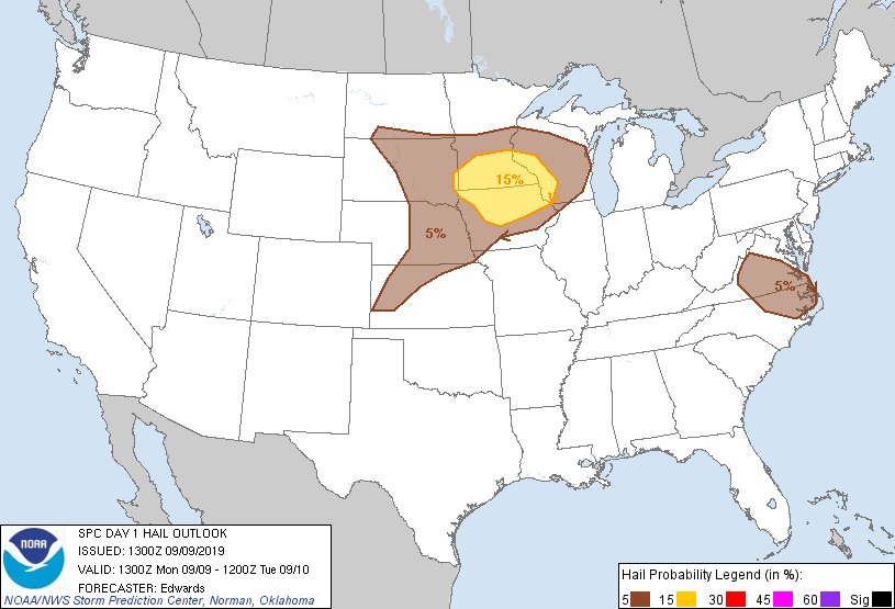 |
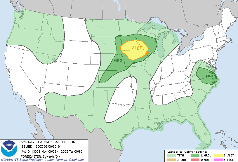
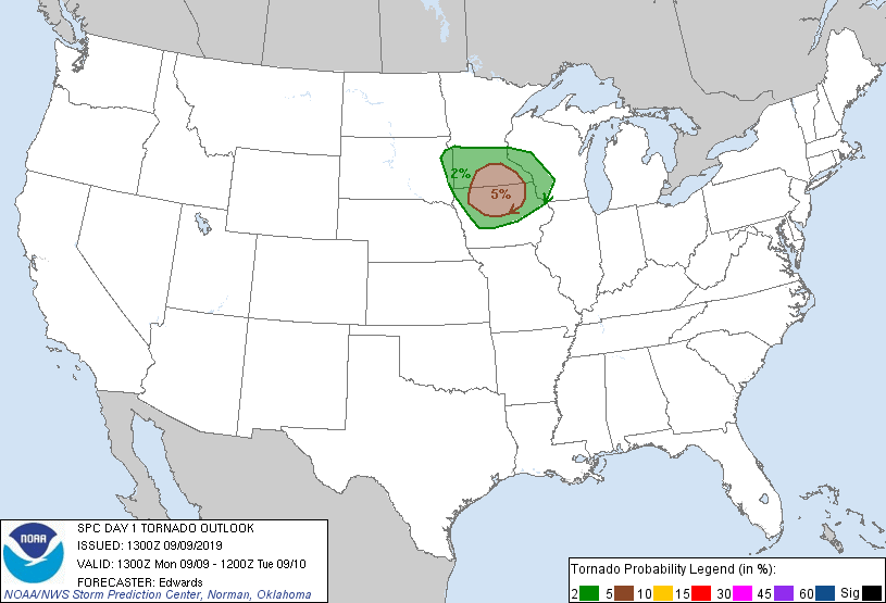
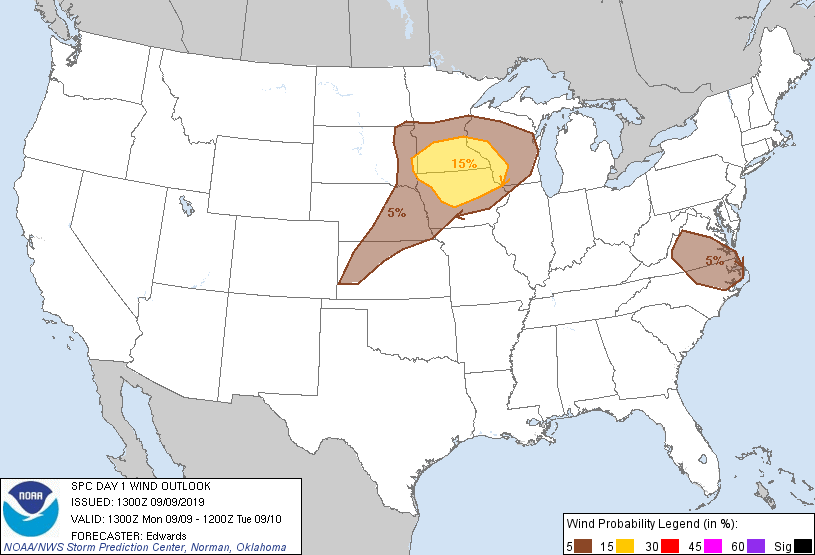
| 8 AM OUTLOOK | 8 AM TORNADO OUTLOOK | 8 AM WIND OUTLOOK | 8 AM HAIL OUTLOOK |
 |
 |
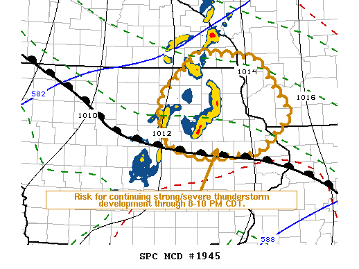 |
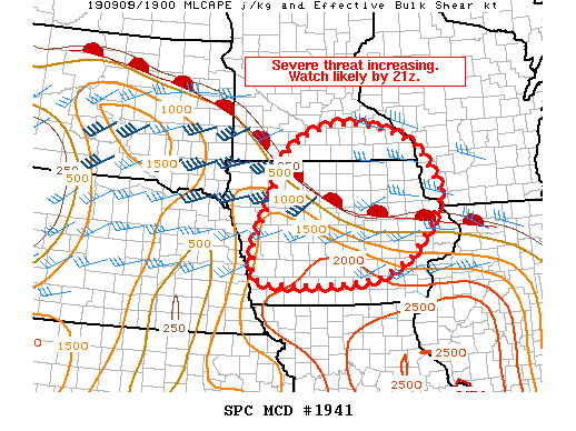
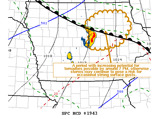
| MCD 1941 | MCD 1943 | MCD 1945 |
 |
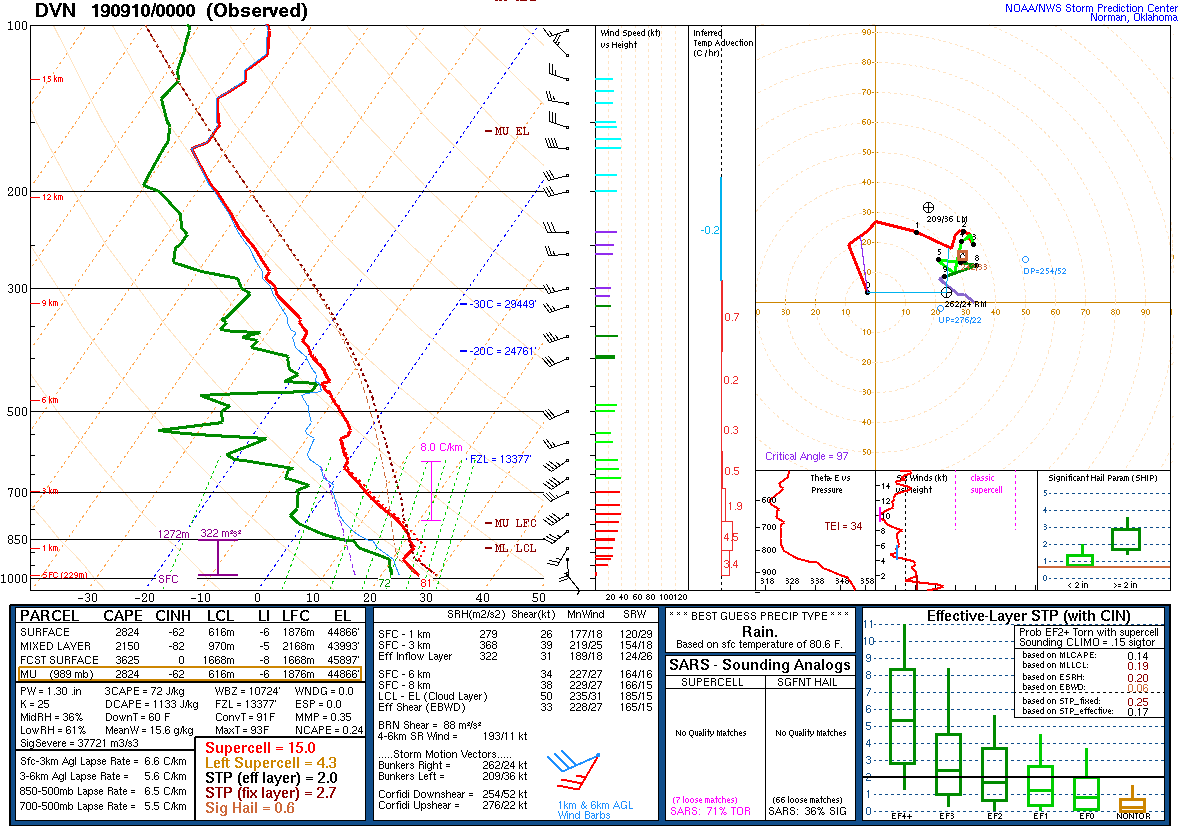 |
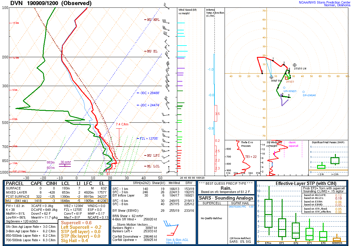
| 7 AM DAVENPORT, IA SOUNDING | 7 PM DAVENPORT, IA |
 |
Media use of NWS Web News Stories is encouraged! Please acknowledge the NWS as the source of any news information accessed from this site. |
|