Severe thunderstorms will be possible from the central Plains to the Mid-Atlantic and Northeast on Monday. Hazardous heat will linger across the southern U.S. and build across the West through mid-week. Hot and dry conditions will fuel fire weather concerns for Interior Alaska and the Four Corners region through Monday. Read More >
Overview
|
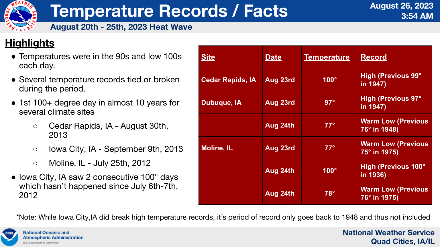
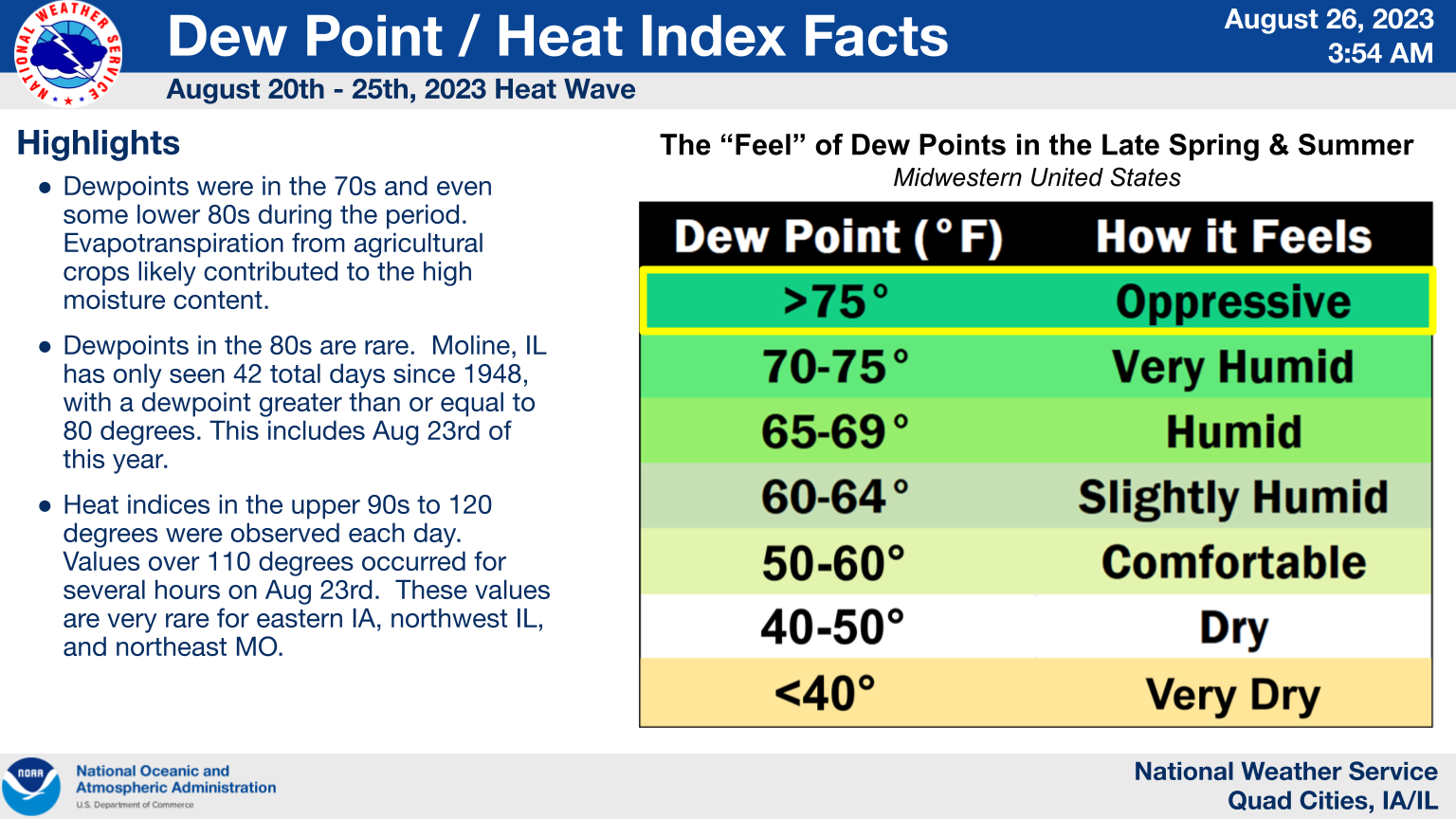
A very large and strong upper level ridge of high pressure over the central United States brought several days of record temperatures during the 4th week of August. Temperatures in the upper 90s to low 100s were observed each day across eastern IA, northwest IL, and northeast MO. These readings combined with dewpoints in the 70s and even low 80s resulted in heat indices over 100 degrees for several hours each day. Several cooling centers were opened during the week and many schools adjusted their schedules and extra-curricular activities to keep kids safe in the heat. Some heat-related illnesses were also reported during the week. |
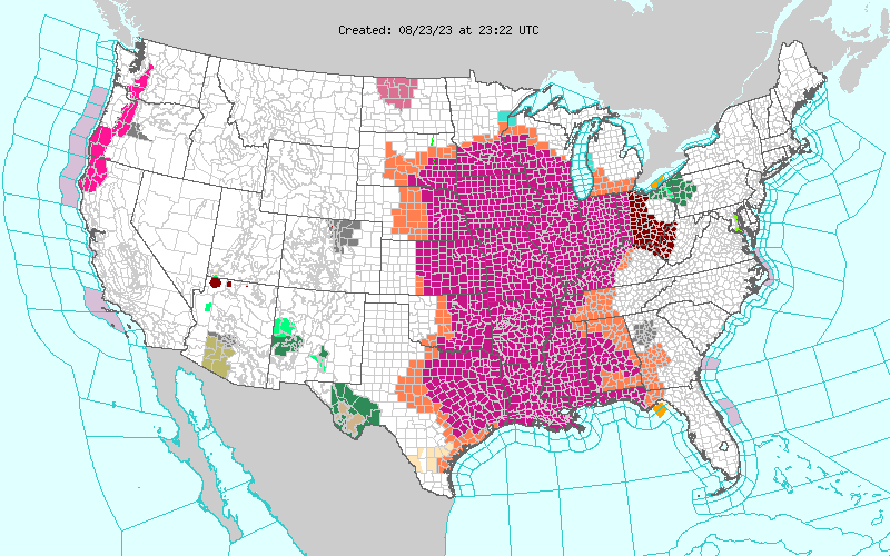 Map showing all of the National Weather Service Watches, Warnings, and Advisories that were in effect the afternoon of Wednesday, August 23rd. The magenta color across much of the central part of the country shows where the Excessive Heat Warnings were in effect on this date. |
Temperature
 |
 |
| Figure 1: Temperature Facts | Figure 2: Moline IL Record High |
Dewpoint / Heat Index
 |
 |
 |
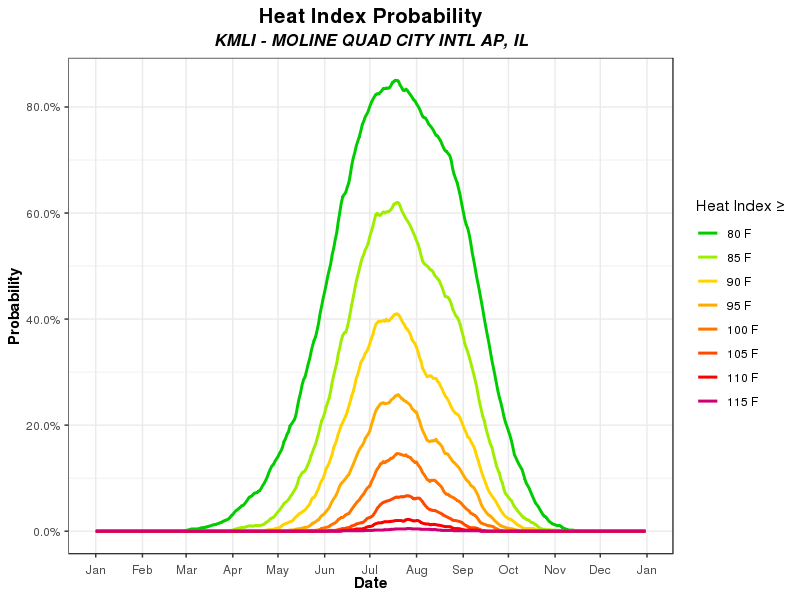 |
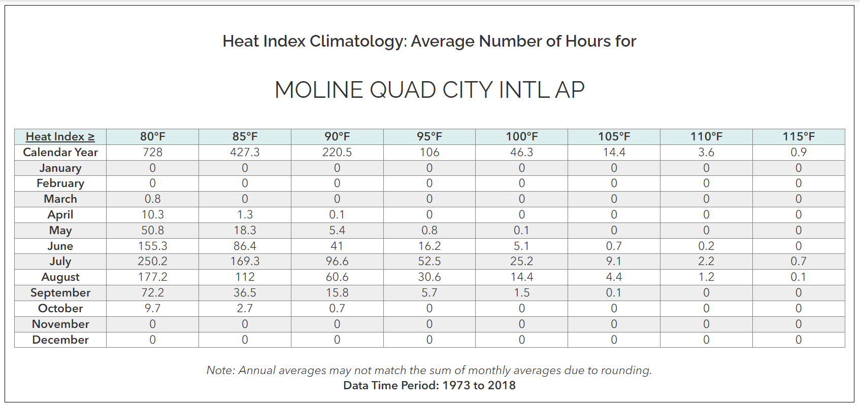
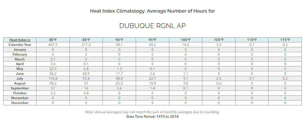
| Figure 1: Dewpoint Facts | Figure 2: Moline, IL Heat Index Climatology | Figure 3: Dubuque, IA Heat Index Climatology | Figure 4: Moline, IL Heat Index Probability |
| Sunday 08/20 Highest Heat Indices | Tuesday 08/22 Highest Heat Indices |
Observations are collected from a variety of sources with varying
equipment and exposures. We thank all volunteer weather observers
for their dedication. Not all data listed are considered official.

Location                   Heat Index  Time/Date       Provider

Keokuk Arpt                  113 F     0315 PM 08/20   AWOS
Marion                       113 F     0315 PM 08/20   CWOP
Olin                         113 F     0410 PM 08/20   CWOP
Freeport Arpt                113 F     0415 PM 08/20   AWOS
Eldridge                     113 F     0515 PM 08/20   CWOP
Dubuque                      112 F     0236 PM 08/20   CWOP
Dubuque                      112 F     0258 PM 08/20   CWOP
Macomb                       112 F     0330 PM 08/20   CWOP
Sigourney                    112 F     0340 PM 08/20   MESOWEST
University Heights           112 F     0340 PM 08/20   MESOWEST
Sterling/Rock Falls Arpt     112 F     0356 PM 08/20   AWOS
De Witt                      112 F     0455 PM 08/20   MESOWEST
Iowa City                    112 F     0617 PM 08/20   CWOP
Cedar River Tnc Swamp        111 F     1246 PM 08/20   RAWS
Milan                        111 F     0228 PM 08/20   CWOP
Independence                 111 F     0300 PM 08/20   CWOP
1.4 S Hills                  111 F     0320 PM 08/20   MESOWEST
Independence                 111 F     0330 PM 08/20   CWOP
Robins                       111 F     0411 PM 08/20   CWOP
Macomb                       111 F     0427 PM 08/20   CWOP
Stronghurst                  111 F     0439 PM 08/20   CWOP
Shimek State Forest          111 F     0507 PM 08/20   RAWS
Fort Madison Arpt            111 F     0535 PM 08/20   AWOS
Iowa City I-80               111 F     0545 PM 08/20   MESOWEST
Iowa City                    110 F     0139 PM 08/20   CWOP
Dubuque                      110 F     0225 PM 08/20   MESOWEST
Victor                       110 F     0420 PM 08/20   MESOWEST
3 S Mount Joy                110 F     0445 PM 08/20   AWS
Williamsburg                 110 F     0550 PM 08/20   MESOWEST
Muscatine Arpt               109 F     1235 PM 08/20   AWOS
Monmouth                     109 F     0235 PM 08/20   CWOP
Monmouth                     109 F     0315 PM 08/20   ISWS
Aurora                       109 F     0315 PM 08/20   CWOP
Davenport Arpt               109 F     0352 PM 08/20   ASOS
Riverside                    109 F     0428 PM 08/20   CWOP
Tipton                       109 F     0440 PM 08/20   CWOP
Tipton                       109 F     0500 PM 08/20   MESOWEST
Stockton                     108 F     0245 PM 08/20   CWOP
Burlington Arpt              108 F     0253 PM 08/20   ASOS
New London                   108 F     0350 PM 08/20   CWOP
Fairfield Arpt               108 F     0415 PM 08/20   AWOS
Iowa City                    108 F     0443 PM 08/20   CWOP
Flagstaff Cheshire           108 F     0445 PM 08/20   CWOP
Clinton Arpt                 108 F     0556 PM 08/20   AWOS
Fairbank                     107 F     0230 PM 08/20   CWOP
Quad Cities                  107 F     0435 PM 08/20   MESOWEST
Urbana                       107 F     0445 PM 08/20   CWOP
Savanna Arpt                 107 F     0523 PM 08/20   AWOS
Big Bend                     107 F     0525 PM 08/20   ISWS
Iowa City                    107 F     0557 PM 08/20   CWOP
Davenport                    107 F     0600 PM 08/20   CWOP
Winthrop                     106 F     0300 PM 08/20   CWOP
Cedar Rapids Arpt            106 F     0352 PM 08/20   ASOS
Dubuque Arpt                 106 F     0353 PM 08/20   ASOS
Anamosa                      106 F     0430 PM 08/20   MESOWEST
Mount Pleasant Arpt          106 F     0455 PM 08/20   AWOS
Iowa City Arpt               106 F     0552 PM 08/20   ASOS
Muscatine                    105 F     0415 PM 08/20   CWOP
Maquoketa                    105 F     0435 PM 08/20   MESOWEST
Quad City Intl Arpt          105 F     0452 PM 08/20   ASOS
Cedar Rapids I-380           105 F     0500 PM 08/20   MESOWEST
Manchester                   104 F     0150 PM 08/20   MESOWEST
Freeport                     104 F     0325 PM 08/20   ISWS
Independence Arpt            103 F     0235 PM 08/20   AWOS
|
Observations are collected from a variety of sources with varying
equipment and exposures. We thank all volunteer weather observers
for their dedication. Not all data listed are considered official.

Location                   Heat Index  Time/Date       Provider

Macomb                       116 F     0445 PM 08/22   CWOP
Keokuk Arpt                  116 F     0435 PM 08/22   AWOS
Cantril                      116 F     0500 PM 08/22   MESOWEST
New London                   115 F     0620 PM 08/22   CWOP
Stronghurst                  115 F     0432 PM 08/22   CWOP
Independence                 115 F     0400 PM 08/22   CWOP
Aurora                       115 F     0500 PM 08/22   CWOP
Marion                       114 F     0500 PM 08/22   CWOP
Iowa City                    114 F     0658 PM 08/22   CWOP
Dubuque                      114 F     0527 PM 08/22   CWOP
Iowa City                    114 F     0419 PM 08/22   CWOP
Mount Pleasant               114 F     0500 PM 08/22   MESOWEST
Freeport                     113 F     0558 PM 08/22   CWOP
Shimek State Forest          113 F     0307 PM 08/22   RAWS
Fort Madison Arpt            113 F     0535 PM 08/22   AWOS
Sigourney                    113 F     0500 PM 08/22   MESOWEST
Muscatine Arpt               112 F     0735 PM 08/22   AWOS
Urbana                       112 F     0500 PM 08/22   MESOWEST
1.4 S Hills                  111 F     0650 PM 08/22   MESOWEST
Winthrop                     111 F     0345 PM 08/22   CWOP
Cedar Rapids                 111 F     0430 PM 08/22   CWOP
Buffalo                      111 F     0403 PM 08/22   CWOP
Riverside                    111 F     0525 PM 08/22   CWOP
Dubuque                      111 F     0500 PM 08/22   MESOWEST
Iowa City I-80               111 F     0500 PM 08/22   MESOWEST
Urbana                       110 F     0500 PM 08/22   CWOP
Iowa City                    110 F     0538 PM 08/22   CWOP
Mt. Carroll                  110 F     0551 PM 08/22   CWOP
Iowa City                    110 F     0548 PM 08/22   CWOP
Tipton                       110 F     0500 PM 08/22   MESOWEST
Williamsburg                 110 F     0500 PM 08/22   MESOWEST
University Heights           109 F     0640 PM 08/22   MESOWEST
Olin                         109 F     0425 PM 08/22   CWOP
Tipton                       109 F     0530 PM 08/22   CWOP
Monmouth                     109 F     0535 PM 08/22   ISWS
Iowa City Arpt               109 F     0552 PM 08/22   ASOS
3 S Mount Joy                108 F     0535 PM 08/22   AWS
Milan                        108 F     0508 PM 08/22   CWOP
Marion                       108 F     0515 PM 08/22   CWOP
Mount Carroll                108 F     0300 PM 08/22   CWOP
Eldridge                     108 F     0446 PM 08/22   CWOP
Robins                       108 F     0555 PM 08/22   CWOP
Burlington Arpt              108 F     0553 PM 08/22   ASOS
Cedar Rapids Arpt            108 F     0452 PM 08/22   ASOS
Independence Arpt            108 F     0455 PM 08/22   AWOS
Mount Pleasant Arpt          108 F     0415 PM 08/22   AWOS
Sterling                     107 F     0449 PM 08/22   CWOP
Dubuque                      107 F     0626 PM 08/22   CWOP
Fairfield Arpt               107 F     0455 PM 08/22   AWOS
Victor                       107 F     0500 PM 08/22   MESOWEST
Lone Tree                    106 F     0420 PM 08/22   MESOWEST
Middleburg                   106 F     0615 PM 08/22   CWOP
Dubuque                      106 F     0619 PM 08/22   CWOP
Monmouth                     106 F     0535 PM 08/22   CWOP
Clinton Arpt                 105 F     0556 PM 08/22   AWOS
Davenport Arpt               105 F     0452 PM 08/22   ASOS
Anamosa                      105 F     0500 PM 08/22   MESOWEST
Manchester                   105 F     0500 PM 08/22   MESOWEST
Davenport                    104 F     0645 PM 08/22   CWOP
Big Bend                     103 F     0635 PM 08/22   ISWS
Sterling/Rock Falls Arpt     103 F     0456 PM 08/22   AWOS
Spring Valley Airport        103 F     0435 PM 08/22   AWS
Quad City Intl Arpt          102 F     0552 PM 08/22   ASOS
Cedar Rapids I-380           102 F     0505 PM 08/22   MESOWEST
Quad Cities                  101 F     0500 PM 08/22   MESOWEST
Muscatine                    100 F     0500 PM 08/22   CWOP
Savanna Arpt                 100 F     0615 PM 08/22   AWOS
Maquoketa                    100 F     0500 PM 08/22   MESOWEST
|
| Wednesday 08/23 Highest Heat Indices | Thursday 08/24 Highest Heat Indices |
Observations are collected from a variety of sources with varying
equipment and exposures. We thank all volunteer weather observers
for their dedication. Not all data listed are considered official.

Location                   Heat Index  Time/Date       Provider

Kahoka                       124 F     0229 PM 08/23   CWOP
ROBINS                       124 F     0302 PM 08/23   CWOP
Muscatine Arpt               124 F     0635 PM 08/23   AWOS
University Heights           123 F     0450 PM 08/23   MESOWEST
Flagstaff Cheshire           123 F     0430 PM 08/23   CWOP
Urbana                       123 F     0400 PM 08/23   CWOP
Davenport                    123 F     0415 PM 08/23   CWOP
Stockton                     123 F     0425 PM 08/23   CWOP
Eldridge                     123 F     0456 PM 08/23   CWOP
Macomb                       123 F     0219 PM 08/23   CWOP
Clinton Arpt                 123 F     0356 PM 08/23   AWOS
Savanna Arpt                 123 F     0438 PM 08/23   AWOS
Sterling/Rock Falls Arpt     123 F     0156 PM 08/23   AWOS
Stronghurst                  122 F     0242 PM 08/23   CWOP
Macomb                       122 F     0315 PM 08/23   CWOP
Big Bend                     122 F     0335 PM 08/23   ISWS
3 S Mount Joy                121 F     0435 PM 08/23   AWS
3 NW Nauvoo                  121 F     0250 PM 08/23   AWS
New London                   120 F     0420 PM 08/23   CWOP
Shimek State Forest          120 F     0407 PM 08/23   RAWS
Freeport                     120 F     0235 PM 08/23   ISWS
Monmouth                     120 F     0235 PM 08/23   ISWS
Iowa City Arpt               120 F     0452 PM 08/23   ASOS
Iowa City                    119 F     0448 PM 08/23   CWOP
Dubuque Arpt                 119 F     0353 PM 08/23   ASOS
Davenport Arpt               119 F     1152 AM 08/23   ASOS
Freeport Arpt                119 F     0215 PM 08/23   AWOS
Lone Tree                    118 F     0320 PM 08/23   MESOWEST
Cedar Rapids Arpt            118 F     0352 PM 08/23   ASOS
Monmouth                     117 F     0205 PM 08/23   CWOP
Cedar Rapids                 117 F     0545 PM 08/23   CWOP
Quad City Intl Arpt          117 F     0552 PM 08/23   ASOS
Spring Valley Airport        117 F     0245 PM 08/23   AWS
Keokuk Arpt                  116 F     0315 PM 08/23   AWOS
Fort Madison Arpt            116 F     0315 PM 08/23   AWOS
Independence Arpt            116 F     0135 PM 08/23   AWOS
Dubuque                      115 F     0317 PM 08/23   CWOP
Fairfield Arpt               115 F     0335 PM 08/23   AWOS
Burlington Arpt              114 F     0410 PM 08/23   ASOS
Muscatine                    113 F     0445 PM 08/23   CWOP
Mount Pleasant Arpt          113 F     0455 PM 08/23   AWOS
Dubuque                      112 F     0318 PM 08/23   CWOP
3 NNE Keswick                111 F     0405 PM 08/23   AWS
Dubuque                      110 F     0518 PM 08/23   CWOP
|
Observations are collected from a variety of sources with varying
equipment and exposures. We thank all volunteer weather observers
for their dedication. Not all data listed are considered official.

Location                   Heat Index  Time/Date       Provider

2.5 S Coralville             120 F     0310 PM 08/24   MESOWEST
Dubuque                      120 F     0515 PM 08/24   MESOWEST
Middleburg                   119 F     0515 PM 08/24   CWOP
Olin                         119 F     0335 PM 08/24   CWOP
3 NW Nauvoo                  119 F     0533 PM 08/24   AWS
Shimek State Forest          119 F     0407 PM 08/24   RAWS
Independence                 119 F     0601 PM 08/24   CWOP
Monmouth                     119 F     0355 PM 08/24   ISWS
Sigourney                    119 F     0615 PM 08/24   MESOWEST
Urbana                       118 F     0415 PM 08/24   CWOP
New London                   118 F     0550 PM 08/24   CWOP
Aurora                       118 F     0330 PM 08/24   CWOP
Macomb                       118 F     0345 PM 08/24   CWOP
Monmouth                     118 F     0455 PM 08/24   CWOP
1.4 S Hills                  117 F     0330 PM 08/24   MESOWEST
Davenport                    117 F     0500 PM 08/24   CWOP
Tipton                       117 F     0550 PM 08/24   CWOP
Winthrop                     117 F     0315 PM 08/24   CWOP
Keokuk Arpt                  117 F     0535 PM 08/24   AWOS
Fort Madison Arpt            117 F     0535 PM 08/24   AWOS
Sterling/Rock Falls Arpt     117 F     0456 PM 08/24   AWOS
Williamsburg                 117 F     0140 PM 08/24   MESOWEST
Flagstaff Cheshire           116 F     0430 PM 08/24   CWOP
Macomb                       116 F     0305 PM 08/24   CWOP
Big Bend                     116 F     0225 PM 08/24   ISWS
Freeport                     116 F     0445 PM 08/24   ISWS
Davenport Arpt               116 F     0352 PM 08/24   ASOS
Muscatine Arpt               116 F     0455 PM 08/24   AWOS
De Witt                      116 F     0525 PM 08/24   MESOWEST
Tipton                       116 F     0340 PM 08/24   MESOWEST
Washington                   116 F     0455 PM 08/24   AWS
Iowa City                    115 F     0618 PM 08/24   CWOP
Cedar Rapids                 115 F     0620 PM 08/24   CWOP
Eldridge                     115 F     0226 PM 08/24   CWOP
Robins                       115 F     0548 PM 08/24   CWOP
Iowa City                    115 F     0329 PM 08/24   CWOP
Urbana                       115 F     0710 PM 08/24   MESOWEST
Marion                       114 F     0545 PM 08/24   CWOP
Stockton                     114 F     0515 PM 08/24   CWOP
Riverside                    114 F     0346 PM 08/24   CWOP
Mount Pleasant               114 F     0330 PM 08/24   MESOWEST
University Heights           113 F     0610 PM 08/24   MESOWEST
Burlington Arpt              113 F     0353 PM 08/24   ASOS
Clinton Arpt                 113 F     0156 PM 08/24   AWOS
Savanna Arpt                 113 F     0458 PM 08/24   AWOS
Spring Valley Airport        113 F     0505 PM 08/24   AWS
Lone Tree                    112 F     0410 PM 08/24   MESOWEST
IOWA CITY                    112 F     0528 PM 08/24   CWOP
Stanley                      112 F     0600 PM 08/24   CWOP
Dubuque Arpt                 112 F     0553 PM 08/24   ASOS
Freeport Arpt                112 F     0155 PM 08/24   AWOS
Quad City Intl Arpt          112 F     0552 PM 08/24   ASOS
Cedar Rapids I-380           112 F     0505 PM 08/24   MESOWEST
Independence Arpt            111 F     0355 PM 08/24   AWOS
Iowa City I-80               111 F     0545 PM 08/24   MESOWEST
Manchester                   111 F     0400 PM 08/24   MESOWEST
Muscatine                    110 F     0430 PM 08/24   CWOP
Mount Pleasant Arpt          110 F     1155 AM 08/24   AWOS
Dubuque                      109 F     0548 PM 08/24   CWOP
Iowa City                    109 F     0649 PM 08/24   CWOP
Cedar Rapids Arpt            109 F     0452 PM 08/24   ASOS
Fairfield Arpt               109 F     0415 PM 08/24   AWOS
Iowa City Arpt               109 F     0252 PM 08/24   ASOS
Anamosa                      108 F     0550 PM 08/24   MESOWEST
Dubuque                      106 F     0448 PM 08/24   CWOP
Davenport                    106 F     1110 AM 08/24   MESOWEST
Maquoketa                    106 F     0430 PM 08/24   MESOWEST
Victor                       106 F     0350 PM 08/24   MESOWEST
Dubuque                      104 F     0619 PM 08/24   CWOP
|
Environment
 |
|
|
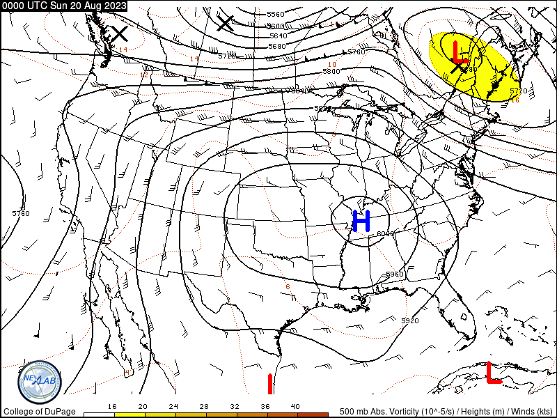
| Figure 1: 500 mb Height Loop Courtesy College of DuPage |
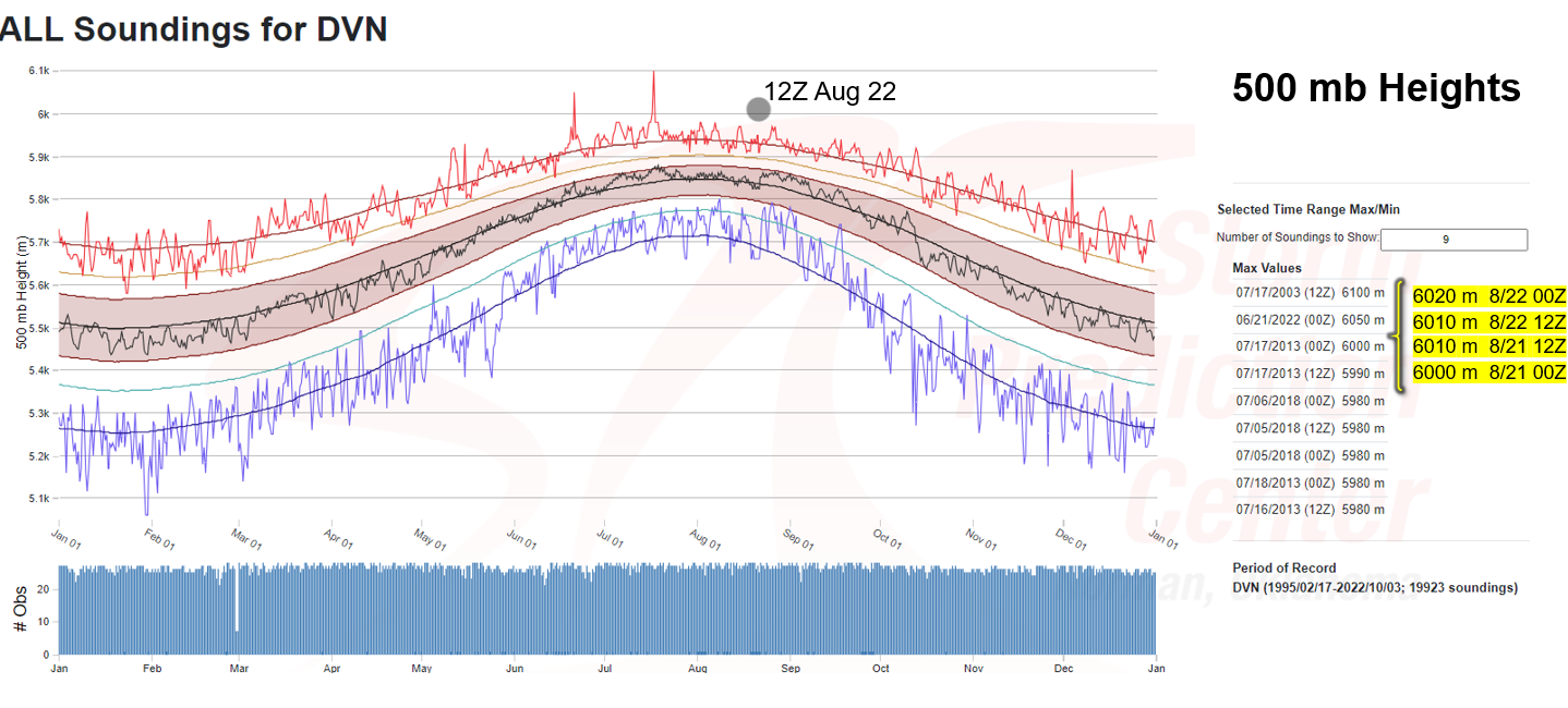
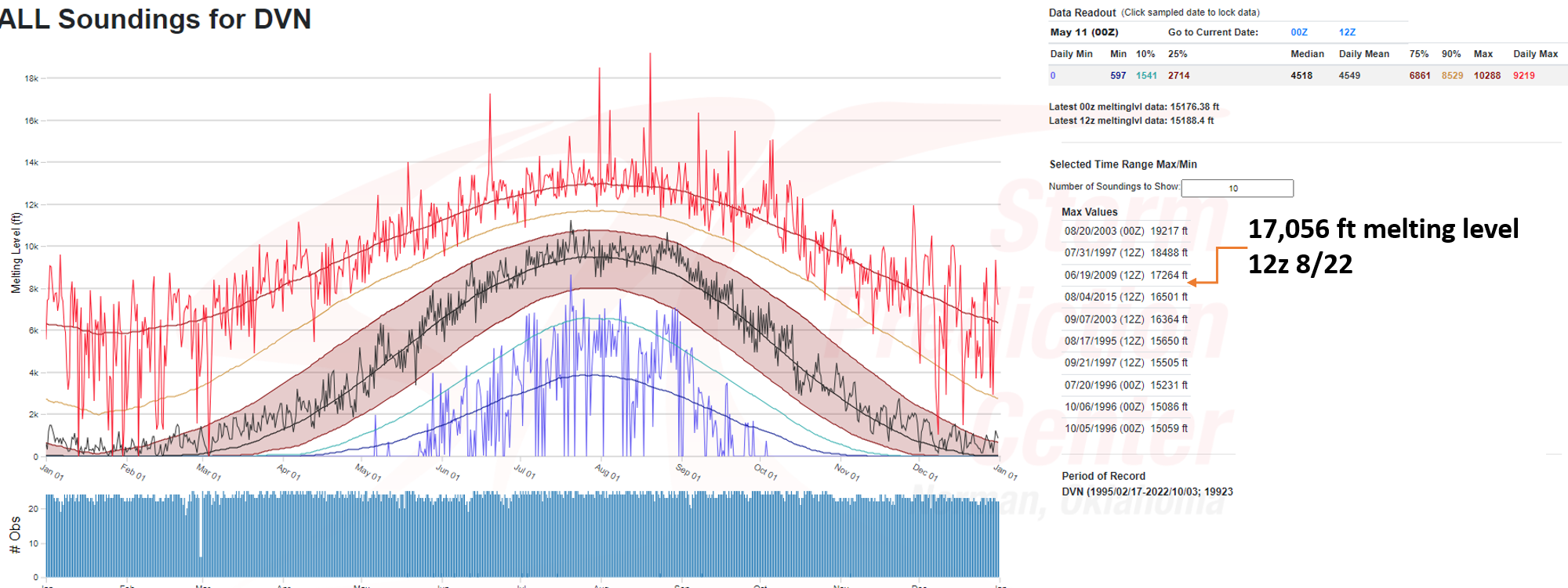
Figure 2: 500mb Climatology | Figure 3: Freezing Level Climatology |
 |
||
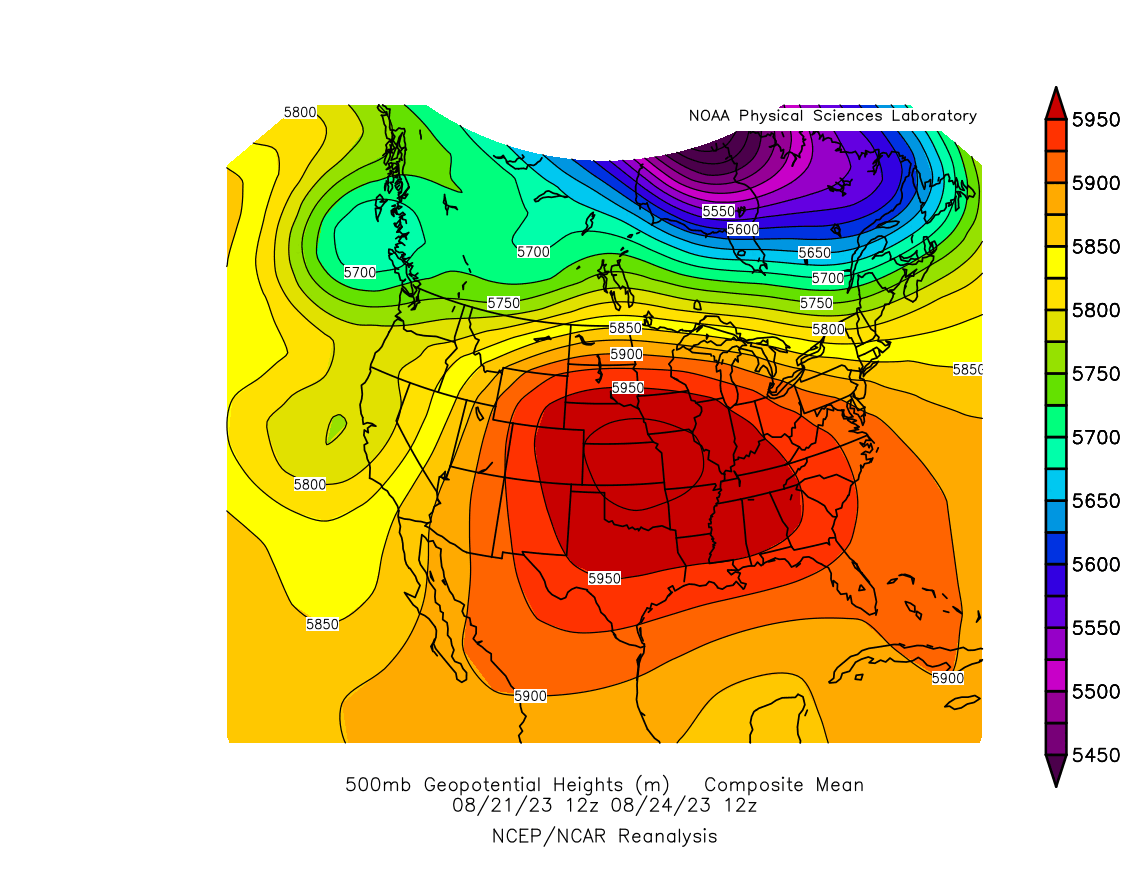
| Figure 4: 500 mb Composite Mean showing a substantial anomalous upper ridge sprawling across the central U.S. This kept weather systems and any cooling effects of cloud cover or precipitation well north near the Canadian border. It also provided a substantial atmospheric depth of heat (as shown in Figure 2) across a huge area, resulting in many locations reaching upper 90s to triple digits across the Corn Belt, Mississippi River Valley, and Plains. |
Links
Summaries from other NWS Offices
 |
Media use of NWS Web News Stories is encouraged! Please acknowledge the NWS as the source of any news information accessed from this site. |
|