Scattered severe thunderstorms capable of damaging wind gusts and some hail are expected this afternoon and evening from the Upper Ohio River Valley into the Northeast, and from the Appalachians into the Mid-Atlantic States. Excessive rainfall from heavy thunderstorms may produce areas of flash flooding from southern New Mexico into the western and northern Gulf Coast into Wednesday. Read More >
Event Summary: August 20, 2019
|
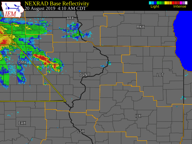
A line of strong to severe thunderstorms impacted much of eastern Iowa, northwest Illinois, and northeast Missouri early Tuesday morning. This line of storms produced wind gusts to 70 MPH and several reports of wind damage. Several trees and power lines were taken down in Mediapolis, Monmouth and Roseville. In addition, torrential rainfall fell with storms as they formed along and north of the I-80 and I-380 corridors. Rainfall amounts of 1-4 inches were reported, which lead to flash flooding in southern portions of the Cedar Rapids metro.
|
|
Storm Reports
| SPC Storm Reports |
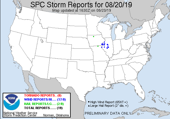 |
| IEM MESONET STORM REPORTS |
PRELIMINARY LOCAL STORM REPORT...SUMMARY
NATIONAL WEATHER SERVICE QUAD CITIES IA IL
1155 AM CDT TUE AUG 20 2019

..TIME...   ...EVENT...      ...CITY LOCATION...     ...LAT.LON...
..DATE...   ....MAG....      ..COUNTY LOCATION..ST.. ...SOURCE....
            ..REMARKS..

1118 AM     HEAVY RAIN       1 ENE MONTPELIER        41.47N 90.78W
08/20/2019  M1.43 INCH       SCOTT              IA   TRAINED SPOTTER

            STORM TOTAL.

1118 AM     HEAVY RAIN       W BELLE PLAINE          41.90N 92.28W
08/20/2019  M3.00 INCH       BENTON             IA   TRAINED SPOTTER

            STORM TOTAL.

1045 AM     HEAVY RAIN       W KEOSAUQUA             40.74N 91.97W
08/20/2019  M1.40 INCH       VAN BUREN          IA   TRAINED SPOTTER


1030 AM     HEAVY RAIN       W CANTRIL               40.64N 92.07W
08/20/2019  M1.30 INCH       VAN BUREN          IA   TRAINED SPOTTER

            STORM TOTAL.

1030 AM     HEAVY RAIN       1 NE FORT MADISON       40.64N 91.33W
08/20/2019  M1.00 INCH       LEE                IA   TRAINED SPOTTER

            STORM TOTAL.

1020 AM     HEAVY RAIN       WEST BURLINGTON         40.82N 91.18W
08/20/2019  M1.00 INCH       DES MOINES         IA   TRAINED SPOTTER

            STORM TOTAL.

1004 AM     HEAVY RAIN       2 NNE CEDAR RAPIDS      42.01N 91.65W
08/20/2019  M1.34 INCH       LINN               IA   TRAINED SPOTTER


1003 AM     HEAVY RAIN       2 WNW DUBUQUE           42.52N 90.72W
08/20/2019  M1.05 INCH       DUBUQUE            IA   TRAINED SPOTTER

            STORM TOTAL.

0940 AM     HEAVY RAIN       2 NNW NORTH LIBERTY     41.76N 91.62W
08/20/2019  M1.41 INCH       JOHNSON            IA   TRAINED SPOTTER

            STORM TOTAL.

0938 AM     HEAVY RAIN       2 W CEDAR RAPIDS        41.98N 91.71W
08/20/2019  M1.52 INCH       LINN               IA   TRAINED SPOTTER

            STORM TOTAL.

0856 AM     LIGHTNING        WASHINGTON              41.31N 91.69W
08/20/2019                   WASHINGTON         IA   EMERGENCY MNGR

            LIGHTNING STRUCK A HOME AND LEAD TO A FIRE.

0848 AM     TSTM WND DMG     MOLINE                  41.49N 90.49W
08/20/2019                   ROCK ISLAND        IL   BROADCAST MEDIA

            LARGE TREE LIMB DOWN AT 12TH STREET AND 25TH
            AVE IN MOLINE. REPORT RELAYED BY BROADCAST
            MEDIA. TIME ESTIMATED FROM RADAR.

0825 AM     TSTM WND DMG     1 W ROSEVILLE           40.73N 90.67W
08/20/2019                   WARREN             IL   TRAINED SPOTTER

            SEVERAL 8 INCH DIAMETER TREE BRANCHES DOWN.
            TIME ESTIMATED FROM RADAR.

0821 AM     HEAVY RAIN       1 NNE WILLIAMSBURG      41.68N 92.00W
08/20/2019  M3.10 INCH       IOWA               IA   TRAINED SPOTTER

            .

0820 AM     TSTM WND DMG     MONMOUTH                40.91N 90.64W
08/20/2019                   WARREN             IL   LAW ENFORCEMENT

            TREES AND POWER LINES DOWN IN MONMOUTH AND
            JUST TO THE NORTH OF THE CITY. TIME
            ESTIMATED FROM RADAR.

0755 AM     TSTM WND DMG     MEDIAPOLIS              41.01N 91.16W
08/20/2019                   DES MOINES         IA   EMERGENCY MNGR

            SEVERAL REPORTS OF LARGE TREES AND BRANCHES
            DOWN, ALONG WITH A LEANING POWER POLE BEING
            HELP BY POWER LINES.

0755 AM     TSTM WND GST     MIDDLETOWN              40.83N 91.26W
08/20/2019  E65 MPH          DES MOINES         IA   TRAINED SPOTTER

            .

0752 AM     HEAVY RAIN       PARNELL                 41.58N 92.01W
08/20/2019  M1.40 INCH       IOWA               IA   TRAINED SPOTTER

            RAINFALL TOTAL SO FAR THIS MORNING.

0750 AM     TSTM WND DMG     MIDDLETOWN              40.83N 91.26W
08/20/2019                   DES MOINES         IA   PUBLIC

            LARGE 6-8 INCH DIAMETER TREE DOWN IN
            BACKYARD. RECEIVED PHOTO FROM SOCIAL MEDIA.

0744 AM     TSTM WND GST     NEW LONDON              40.93N 91.41W
08/20/2019  M70 MPH          HENRY              IA   TRAINED SPOTTER

            SPOTTER REPORT RELAYED BY EMERGENCY
            MANAGEMENT.

0743 AM     HEAVY RAIN       KEYSTONE                42.00N 92.20W
08/20/2019  M3.72 INCH       BENTON             IA   PUBLIC

            SPOTTER REPORT RELAYED FROM BROADCAST MEDIA.
            TOTAL RAINFALL SO FAR.

0730 AM     LIGHTNING        2 ENE OAKDALE           41.71N 91.56W
08/20/2019                   JOHNSON            IA   BROADCAST MEDIA

            LIGHTNING STRUCK A HOME AND CAUSED A FIRE.
            REPORT RELAYED BY BROADCAST MEDIA.

0656 AM     FLASH FLOOD      2 S CEDAR RAPIDS        41.94N 91.68W
08/20/2019                   LINN               IA   BROADCAST MEDIA

            SEVERAL ROADS EXPERIENCING FLASH FLOODING
            ACROSS SOUTHERN CEDAR RAPIDS METRO. ONE CAR
            STALLED NEAR THE INTERSECTION OF 33RD AVE SW
            AND 6TH ST SW.

0650 AM     TSTM WND DMG     SIGOURNEY               41.33N 92.21W
08/20/2019                   KEOKUK             IA   BROADCAST MEDIA

            REPORT OF TREE AND POWER LINE DAMAGE IN
            SIGOURNEY RELAYED FROM BROADCAST MEDIA. TIME
            ESTIMATED FROM RADAR.
|
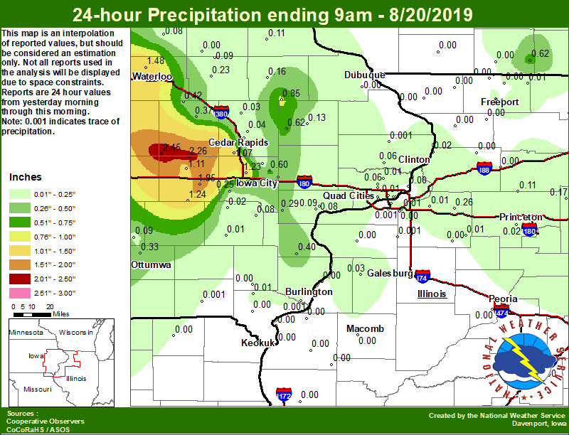
Area Rainfall Amounts
|
24-hr Local Rainfall Map |
 |
|
24 hour precipitation reports (in Inches), Tuesday August 20, 2019.
....IOWA....
Belle Plaine                     2.45
Marengo 3.6 N                    2.26
Williamsburg                     1.95
Marshalltown 1 NW                1.84
Fairfax 4.0 NW                   1.59
NWS Johnston* 5 NNW              1.55
Waterloo ASOS 5 NW               1.48
Toledo 3 N                       1.42
North English                    1.24
North Liberty 0.7 SSW            1.23
Marshalltown ASOS 4 N            1.15
Marengo 2.6 SSW                  1.11
Perry 0 W                        1.09
Cedar Rapids Arpt 5 SW           1.07
Hampton 1 N                      1.00
Hopkinton 5.4 WSW                0.85
Pella 4 N                        0.81
Oskaloosa 1 NNW                  0.70
Anamosa 3 SSW                    0.62
Iowa City 8.0 NE                 0.60
Pella AWOS 2 WSW                 0.57
Boone 1 SSW                      0.45
Mount Auburn 2.2 NNW             0.42
Morning Sun 1.7 E                0.40
West Branch 2.0 NNW              0.38
Vinton                           0.37
Iowa City Arpt                   0.35
Ottumwa ASOS 6 NNW               0.33
Nichols 3.2 SSW                  0.29
Kalona 7.3 NNW                   0.25
Independence 1.2 N               0.23
Mason City 1 NNE                 0.16
Manchester                       0.16
Center Junction 2.6 W            0.13
Elkader 6SSW                     0.11
Stanley                          0.09
Oskaloosa AWOS 9 ESE             0.09
Muscatine 2.1 N                  0.09
Muscatine 2N                     0.08
Tripoli 0 N                      0.08
Ainsworth 7.4 N                  0.08
Center Point 0.6 NNW             0.07
Beaconsfield 1 NNE               0.06
Eldridge 0.7 SSW                 0.06
De Witt                          0.06
Cedar Rapids 2.7 NE              0.04
Marion 1.7 NNW                   0.04
Central City 6.7 W               0.03
Solon 0.3 ESE                    0.03
Davenport Arpt 5 N               0.02
Mason City ASOS 6 W              0.02
Davenport 0.9 WNW                0.02
Riverdale 0.5 N                  0.02
Wellman 4.0 E                    0.02
Asbury 0.4 SW                    0.02
Washington 5.8 SW                0.01
Park View 0.2 WSW                0.01
West Point 7.5 NW                0.01
Bettendorf 1.6 WSW               0.01
Bettendorf 2.2 SE                0.00
Burlington 6.5 SSW               0.00
Cresco 1 NE                      0.00
Burlington Arpt 2 SW             0.00
Charlotte 1.9 WNW                0.00
Davenport 0.9 SSW                0.00
Keosauqua                        0.00
Dubuque Arpt 7 SW                0.00
Le Claire LD14                   0.00
Bellevue LD12                    0.00
Dubuque LD11                     0.00
Oelwein AWOS                     0.00
Donnellson                       0.00
Keokuk LD19                      0.00
Le Claire 1.8 NNE                0.00
Grinnell AWOS 2 SSW              0.00
Salem 3.1 ESE                    0.00
....ILLINOIS....
Atkinson 2.6 NNE                 0.26
Mendota 2 SE                     0.17
Ottawa 4 SW                      0.11
Walnut 5.3 ENE                   0.11
Steward                          0.10
Paw Paw 1 E                      0.04
Monmouth 4NW                     0.03
Streator 3 SE                    0.03
Tiskilwa 2.1 N                   0.02
Fulton LD13                      0.02
Davis 0.5 N                      0.01
Freeport 1.7 ESE                 0.01
Moline 0.7 NNE                   0.01
Freeport 2.0 NW                  0.01
Kewanee 1 E                      0.01
Coal Valley 2.6 E                0.01
Geneseo 2.0 NW                   0.01
Princeton 1.1 SE                 0.00
Quad City Arpt 3 S               0.00
Princeton                        0.00
Freeport 1.7 NW                  0.00
New Windsor 2.0 N                0.00
Aledo                            0.00
Rockford ASOS                    0.00
Mundelein                        0.00
Galva 2.7 NE                     0.00
Decatur Airport                  0.00
Bentley                          0.00
Rock Falls                       0.00
Romeoville                       0.00
Rochelle AWOS                    0.00
Dakota 4.8 NW                    0.00
Gladstone LD18                   0.00
Augusta                          0.00
Freeport                         0.00
Coleta 1.4 SSW                   0.00
Peoria ASOS                      0.00
Colchester 3.5 NE                0.00
Mount Carroll                    0.00
Dallas City 3.0 SSE              0.00
Joliet                           0.00
Nauvoo 0.7 SSE                   0.00
Shannon 0.2 S                    0.00
Quincy ASOS                      0.00
St Anne                          0.00
Bloomington Airport              0.00
Elizabeth                        0.00
Orangeville 2.8 NW               0.00
Coal Valley 1.9 SE               0.00
Winslow 4.3 ESE                  0.00
Stockton 3.4 NNE                 0.00
Rochelle                         0.00
Roscoe 2SE                       0.00
Galesburg Arpt 3 SW              0.00
Lincoln NWS                      0.00
Jacksonville AWOS                0.00
....MISSOURI....
Kirksville ASOS                  0.00
Memphis                          0.00
Chillicothe 2 NW                 0.00
Columbia                         0.00
....WISCONSIN....
Brodhead 1 SW                    0.62
Beloit-College                   0.00
Darlington                       0.00
Watertown-AWOS                   0.00
Allenton-WWTP .6 NW              0.00
Prairie du Chien AWOS            0.00
La Crosse WFO                    0.00
Steuben 4SE 3 NE                 0.00
Monroe 1 W                       0.00
Madison-ASOS                     0.00
Viroqua                          0.00
....MINNESOTA....
Preston                          0.55
|
Environmental Analysis / Other Information
SPC Convective Outlooks
 |
 |
 |
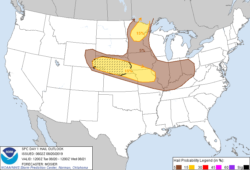 |
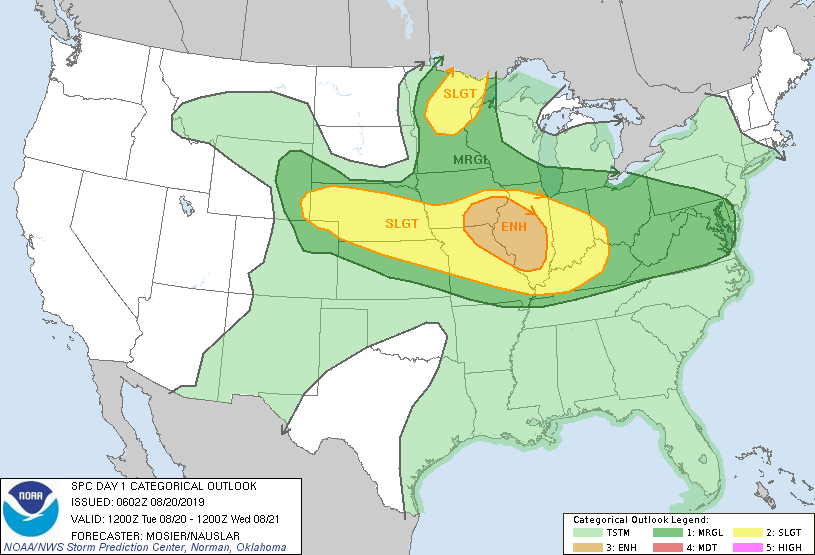
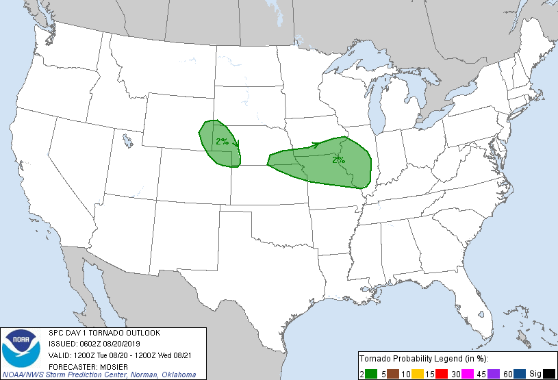
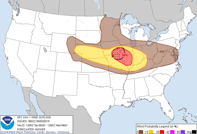
| SPC Day 1 Outlook (2000z) | SPC Day 1 Tornado Outlook (2000z) | SPC Day 1 Wind Outlook (2000z) | SPC Day 1 Hail Outlook (2000z) |
Local Sounding Analysis
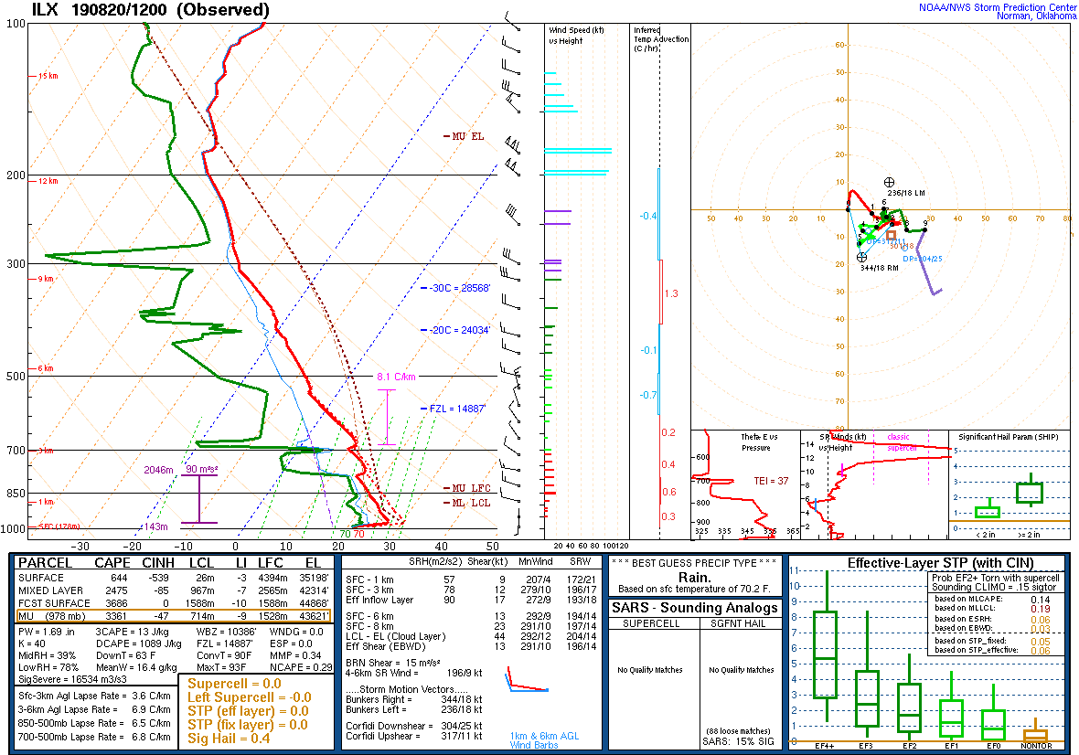 |
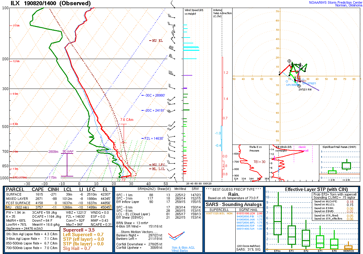 |
| ILX Sounding 8/20/19 12z | DVN Sounding 8/20/19 14z |
SPC Watches Issued For Our Area
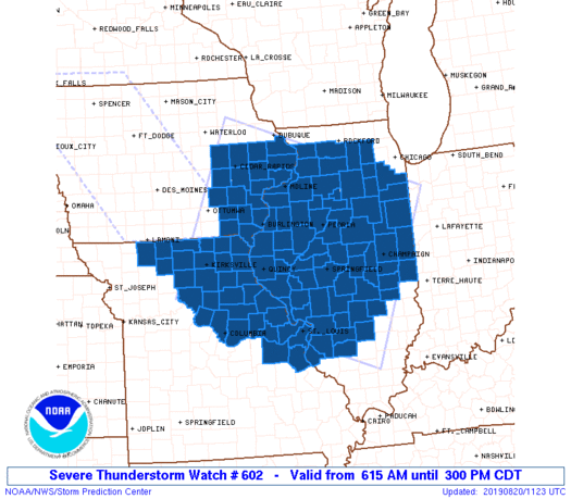 |
| SPC Severe Thunderstorm Watch #602 (see link for more details) |
SPC Mesoscale Discussions Issued For Our Area
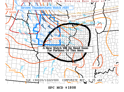 |
 |
||
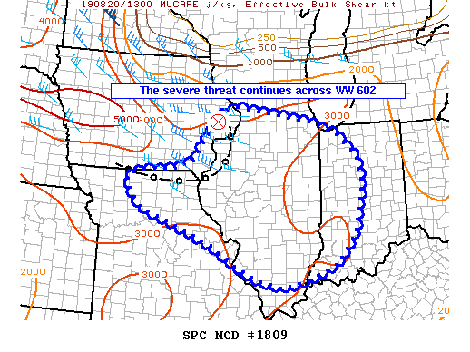
| SPC Mesoscale Discussion #1808 (see link for more details) | SPC Mesoscale Discussion #1809 (see link for more details) |
SPC - Storm Prediction Center
 |
Media use of NWS Web News Stories is encouraged! Please acknowledge the NWS as the source of any news information accessed from this site. |
|