
Scattered severe thunderstorms capable of damaging wind gusts and some hail are expected this afternoon and evening from the Upper Ohio River Valley into the Northeast, and from the Appalachians into the Mid-Atlantic States. Excessive rainfall from heavy thunderstorms may produce areas of flash flooding from southern New Mexico into the western and northern Gulf Coast into Wednesday. Read More >
Overview
|
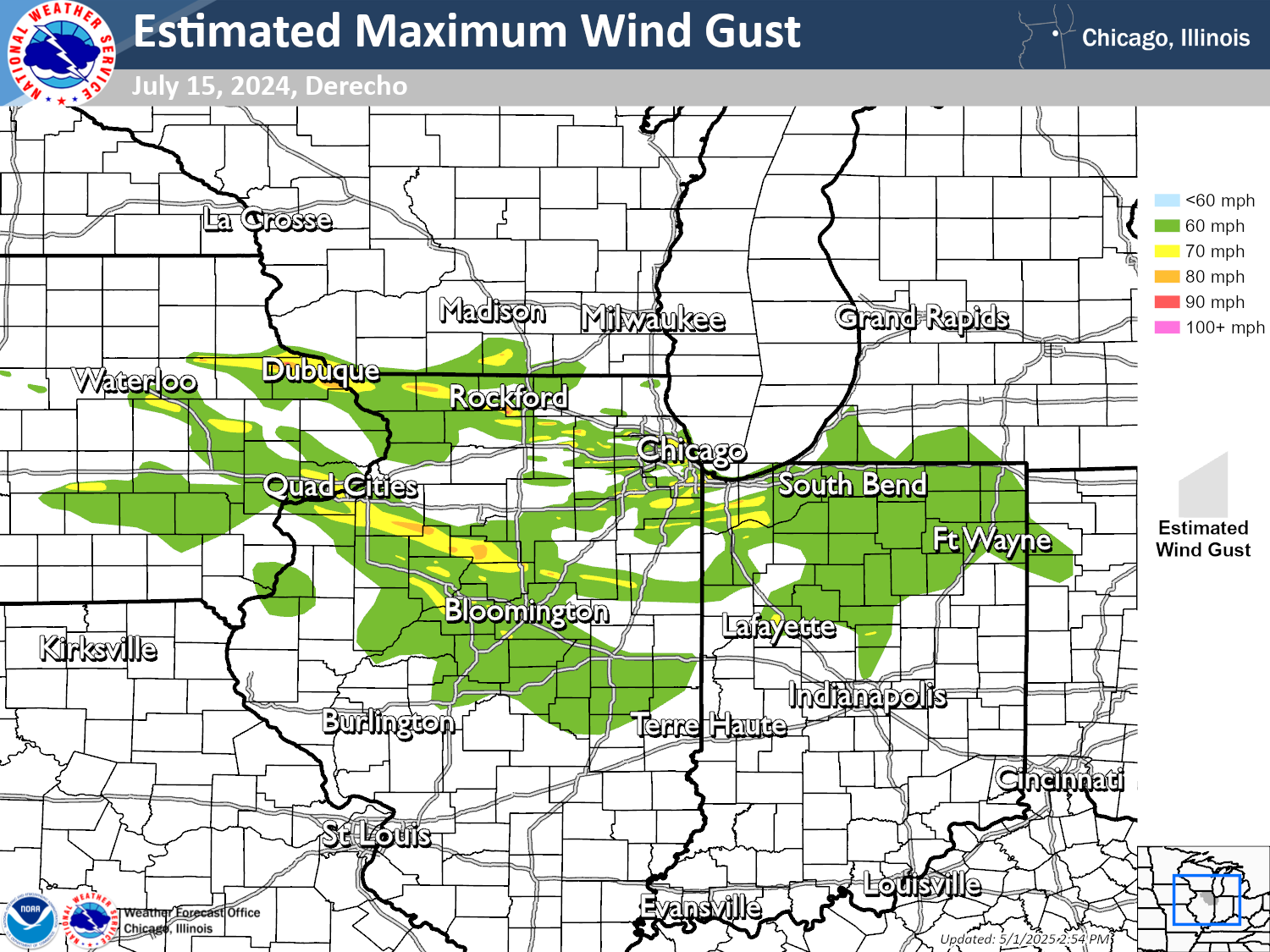
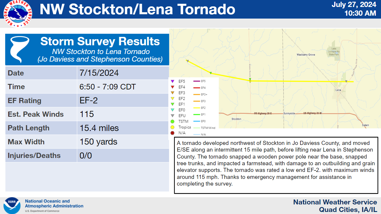
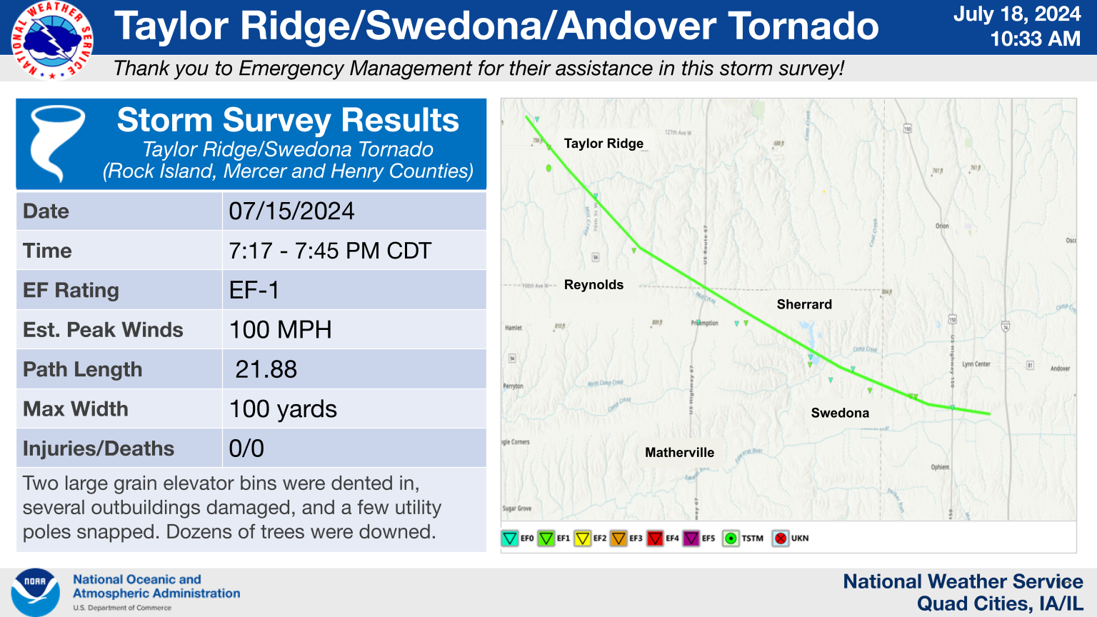
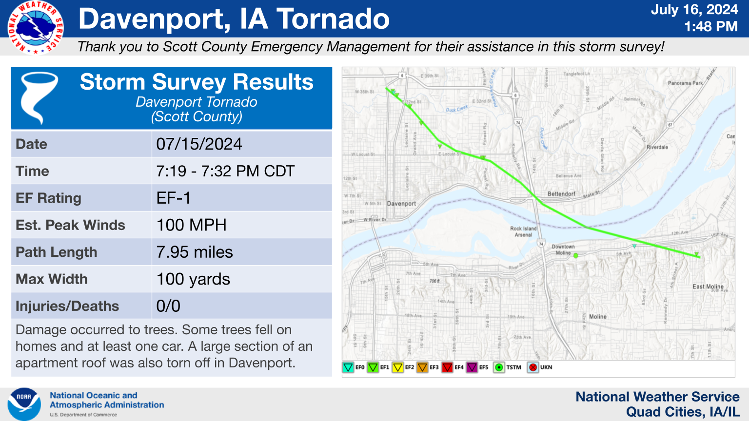
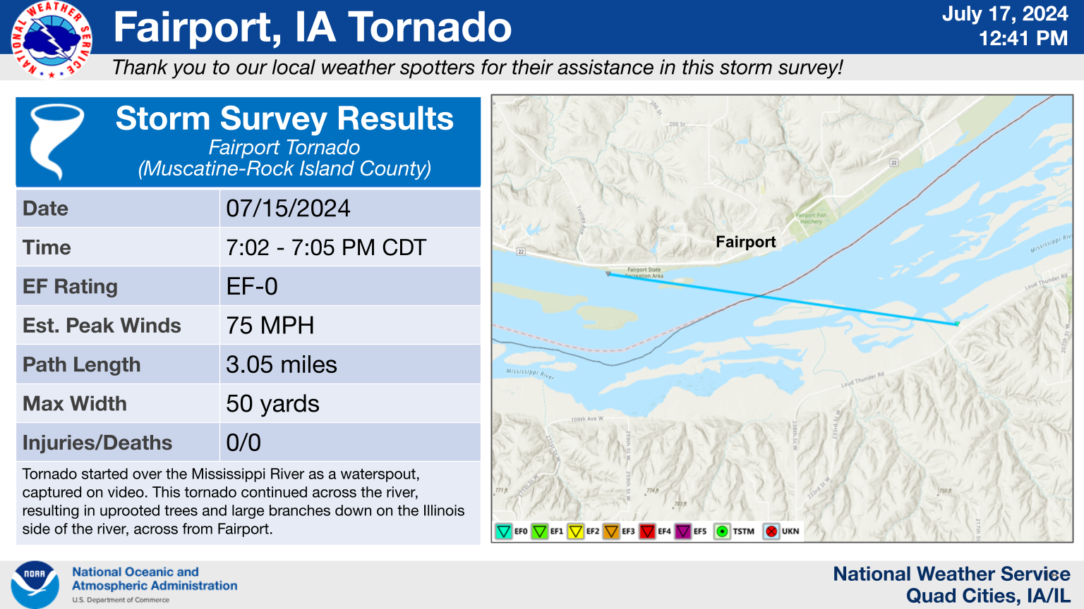
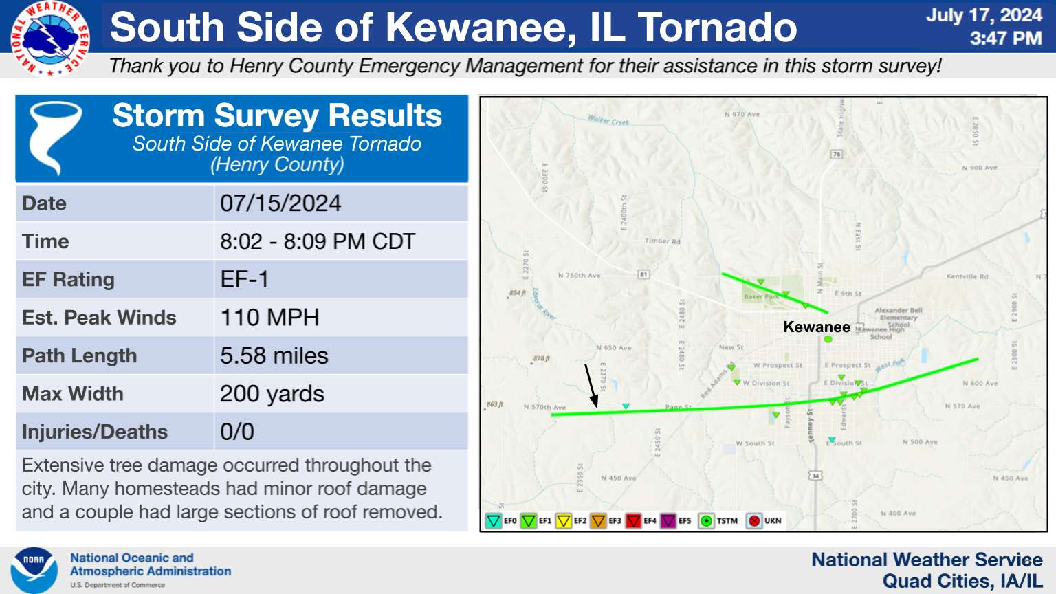
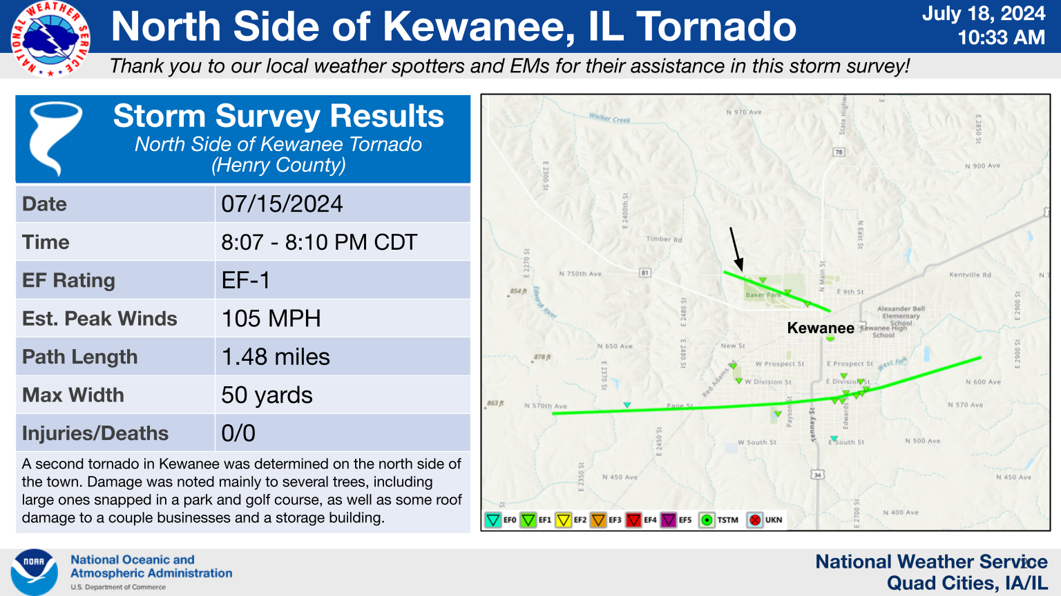
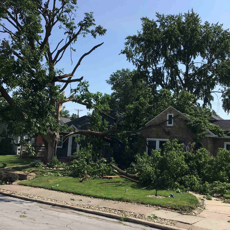
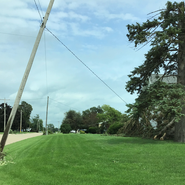
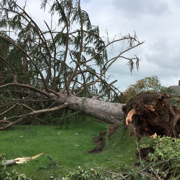
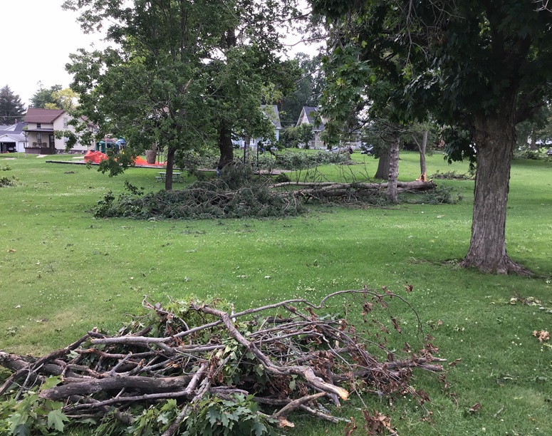
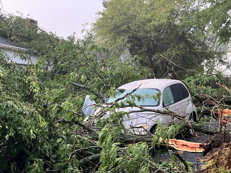
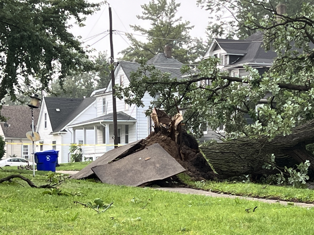
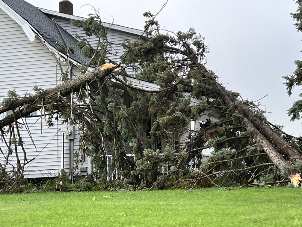
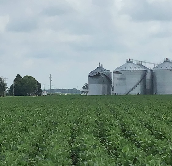
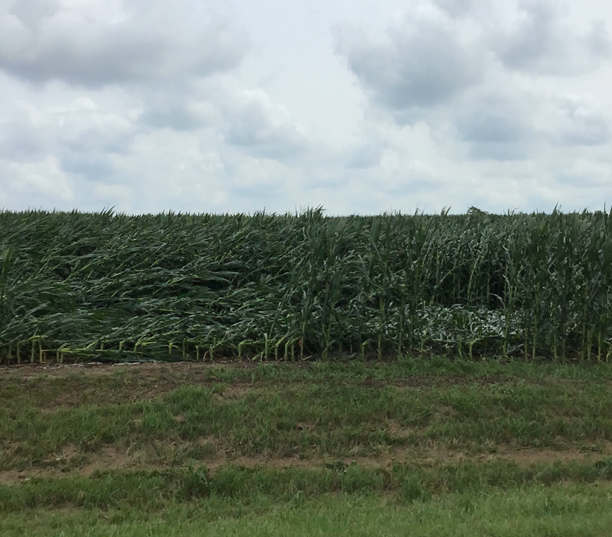
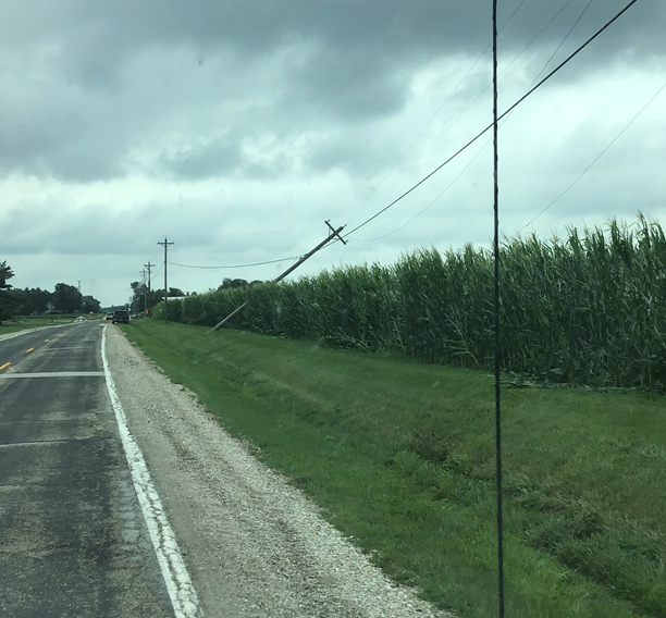
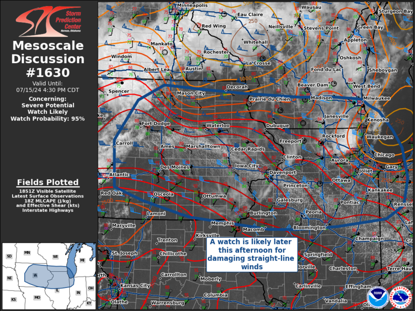
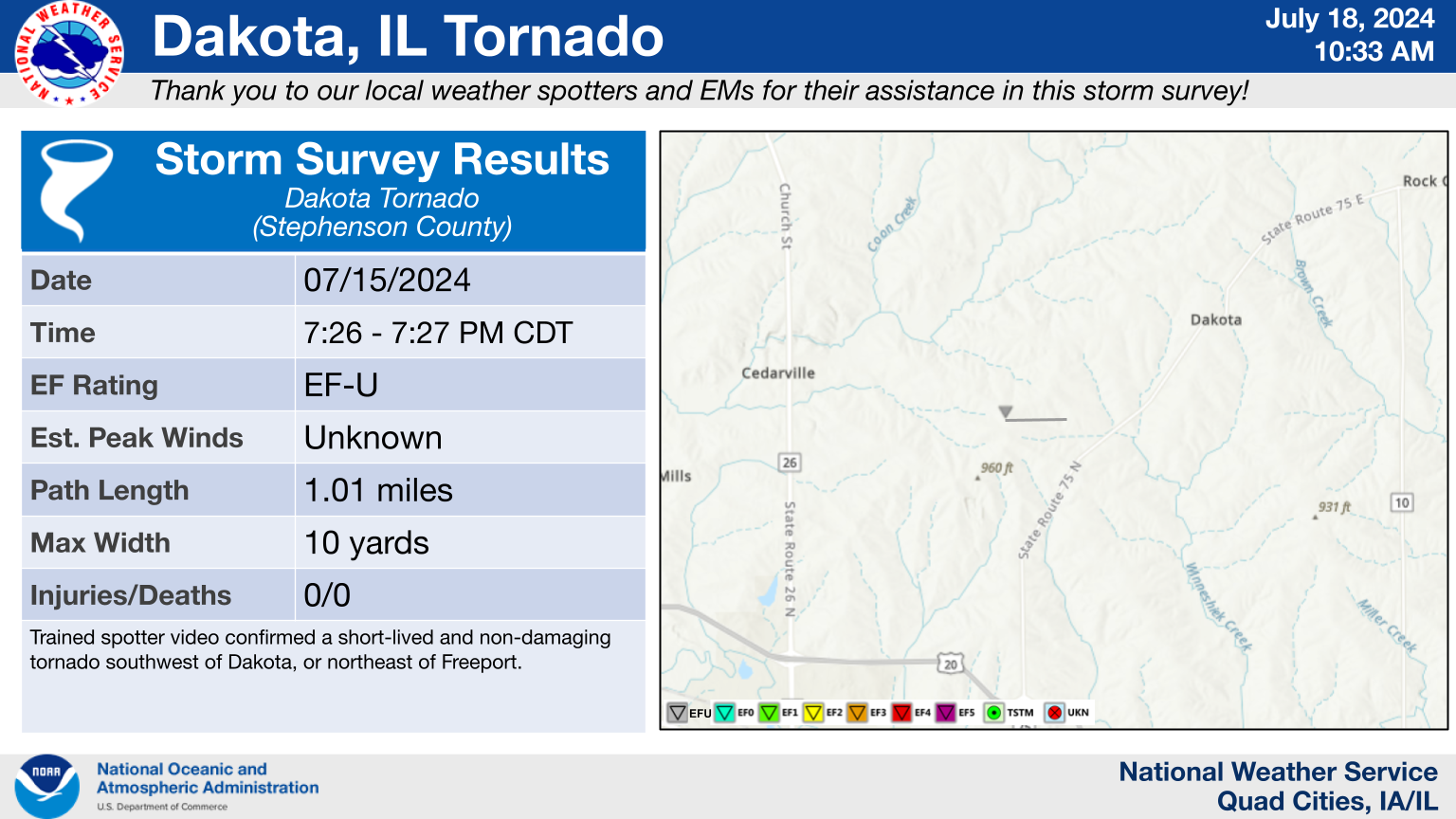
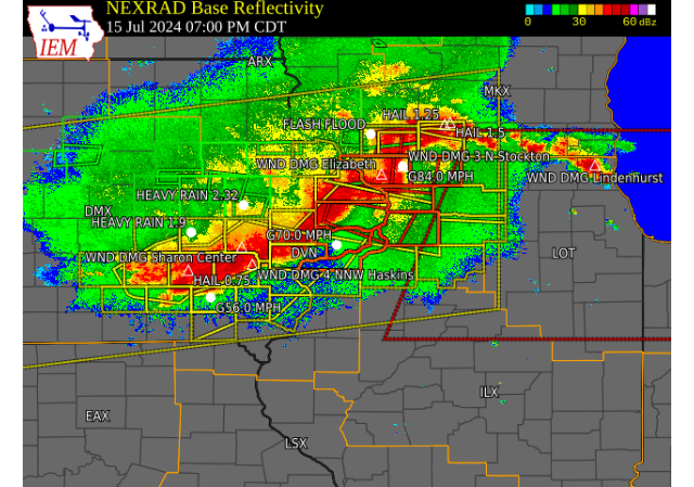
Thunderstorms rapidly developed over northern Iowa Monday afternoon and organized into a powerful line of wind producing storms that surged through the Quad Cities and into northern and central Illinois through the evening hours. These storms brought widespread damaging winds up to 100 mph for many locations extending from eastern Iowa, much of Illinois, and into Indiana. The Storm Prediction Center has classified this event as a "Derecho" which by definition is a swath of wind damage at least 400 miles long and at least 60 miles wide including several well-separated significant wind gusts over 75 mph. For more information on derechos, click here. Corridors of significant wind damage occurred along Highway 20 and in the Cambridge/Kewanee area. 10 tornadoes also occurred with these storms in the NWS Quad Cities service area. In addition to the wind, very heavy rainfall fell in a short amount of time with many locations seeing over an inch. The highest totals fell in McDonough and Warren counties in Illinois where amounts between 2 and 3 inches fell.
KMZ file of tornado paths and damage swaths can be found here.
|
 |
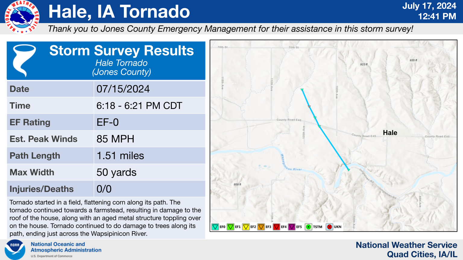
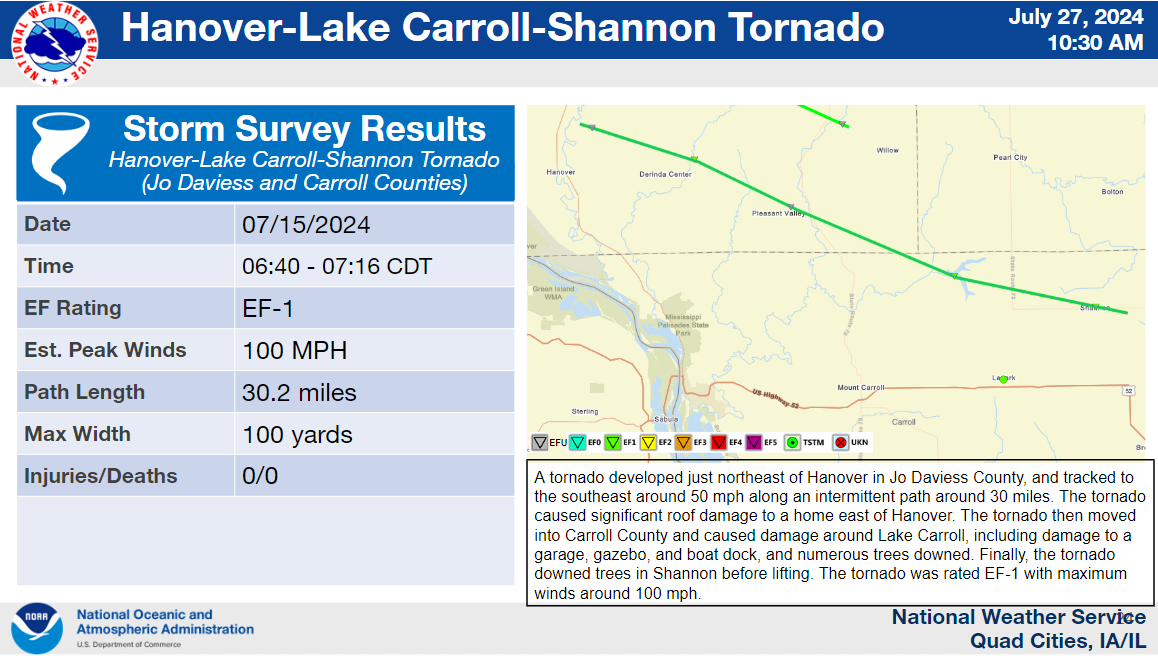
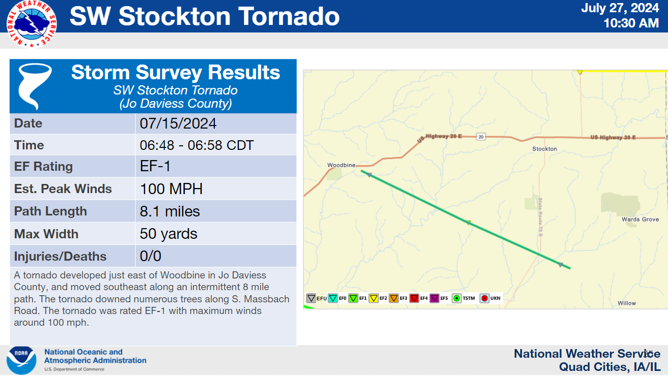
Tornadoes:
Damage Assessment Toolkit - VIEWER
|
1 |
 |
|
2 |
 |
|
3 |
 |
|
4 |
 |
|
5 |
 |
|
6 |
 |
|
7 |
 |
|
8
|
9
10
The Enhanced Fujita (EF) Scale classifies tornadoes into the following categories:
| EF0 Weak 65-85 mph |
EF1 Moderate 86-110 mph |
EF2 Significant 111-135 mph |
EF3 Severe 136-165 mph |
EF4 Extreme 166-200 mph |
EF5 Catastrophic 200+ mph |
 |
|||||
Photos & Video
Davenport, IA NWS Survey Photos
| NWS | NWS | NWS |
 |
 |
 |
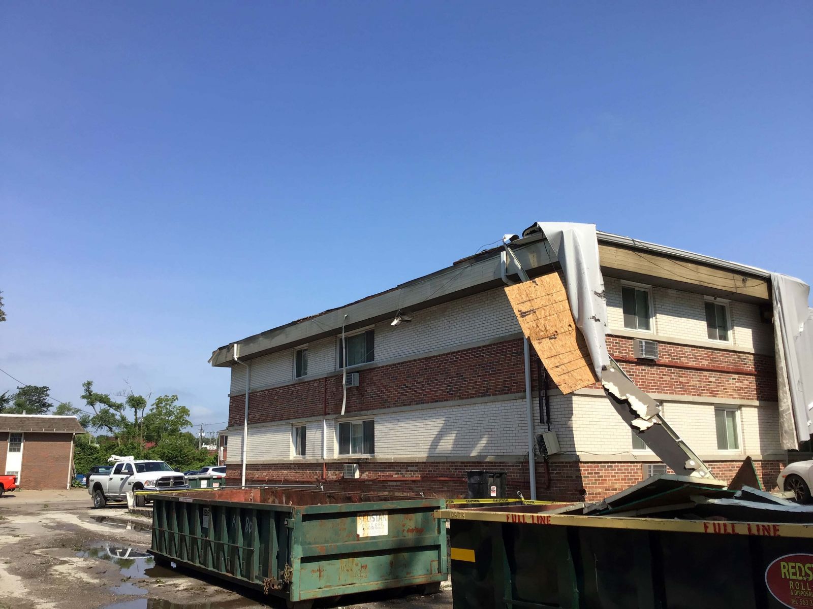
Kewanee, IL NWS Survey Photos
| NWS | NWS | NWS |
 |
 |
 |
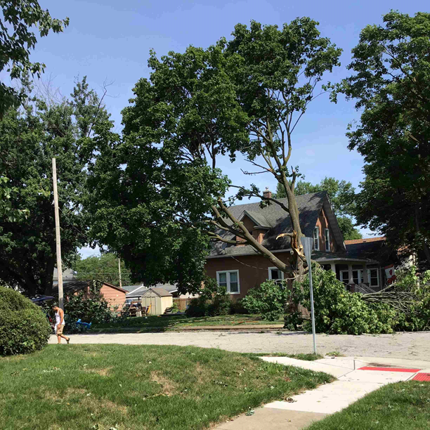
| Kewanee, IL (Jennifer Russell) |
Kewanee, IL (Jennifer Russell) |
Kewanee, IL (Jennifer Russell) |
 |
 |
 |
Taylor Ridge / Andover, IL NWS Survey Photos
| NNWS | NWS | NWS |
 |
 |
 |
| VIDEO form COOP Observer Stockton, IL Wind gusts measured at 84 MPH! Several tree branches down with one about 18" in diameter. Generally from 6:55 PM - 7:00 PM 7/15 |
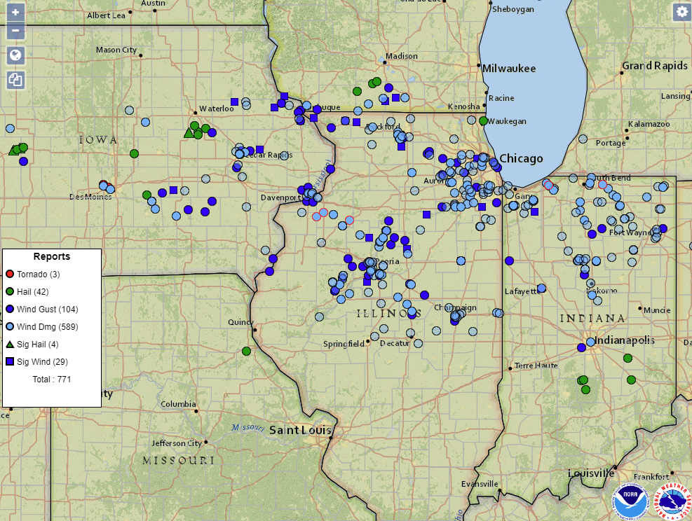
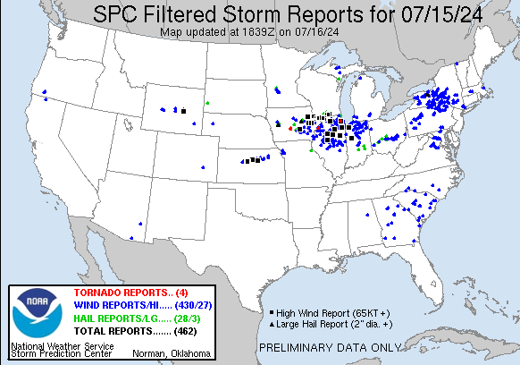
Storm Reports
| Storm Reports | SPC Storm Reports: July 15th, 2024 |
 |
 |
|
Preliminary Local Storm Report...Summary ..TIME... ...EVENT... ...CITY LOCATION... ...LAT.LON... 0514 PM Tstm Wnd Gst Mount Auburn 42.26N 92.09W 0515 PM Tstm Wnd Dmg 3 NNW Dundee 42.62N 91.56W Pine tree snapped off. REPORTED AT BACKBONE 0516 PM Tstm Wnd Gst Independence 42.47N 91.89W 0529 PM Rain Jesup 42.47N 92.07W In the past 60 minutes. 0530 PM Tstm Wnd Gst 1 E Brandon 42.31N 91.98W RWIS. 0532 PM Tstm Wnd Gst Manchester 42.49N 91.46W 0533 PM Tstm Wnd Gst Aurora 42.62N 91.73W Via Aurora FD. 0535 PM Tstm Wnd Gst 1 E Brandon 42.31N 91.98W Mesonet station RURI4 Urbana. 0539 PM Tstm Wnd Gst Marion 42.03N 91.59W Winds estimated at 60 to 70 mph. 0542 PM Tstm Wnd Gst 1 NW Dubuque 42.52N 90.70W Delayed report. 0542 PM Tstm Wnd Gst 2 WNW Marion 42.05N 91.62W 0545 PM Tstm Wnd Gst 1 NE Marion 42.05N 91.57W Mesonet station DW8270 Marion. 0546 PM Tstm Wnd Dmg 1 NNE Robins 42.09N 91.66W 1 foot diameter tree branch down, time 0547 PM Tstm Wnd Dmg 1 E Marion 42.03N 91.57W 2 outdoor sheds destroyed. 0548 PM Tstm Wnd Dmg Dundee 42.58N 91.55W 10 inch tree limbs down. 0550 PM Tstm Wnd Gst New Vienna 42.55N 91.11W Winds estimated at 80+. 0552 PM Tstm Wnd Gst Holy Cross 42.60N 91.00W 0556 PM Tstm Wnd Gst Cedar Rapids Municipali 41.88N 91.72W ASOS. 0557 PM Tstm Wnd Gst 2 WNW Marion 42.05N 91.62W also having some wind driven hail. 0557 PM Tstm Wnd Dmg 1 W Hiawatha 42.04N 91.71W tree branches down. 0558 PM Tstm Wnd Gst Holy Cross 42.60N 91.00W 0558 PM Tstm Wnd Dmg 3 NNE Cedar Rapids 42.01N 91.65W 7 inch tree limb down, time estimated from 0600 PM Tstm Wnd Dmg 2 SSE Hiawatha 42.02N 91.66W Delayed report and time estimated from 0600 PM Flash Flood 1 NNW New Vienna 42.56N 91.12W Flooding on roads west of New Vienna. 0601 PM Tstm Wnd Dmg Rickardsville 42.58N 90.88W 4-6 inch tree limbs down. 0602 PM Tstm Wnd Gst 2 WNW Marion 42.05N 91.63W 0602 PM Tstm Wnd Gst 2 W Paralta 42.05N 91.49W 0605 PM Rain 3 SE Hiawatha 42.02N 91.64W Occurred in the past hour. 0605 PM Tstm Wnd Dmg 2 ENE Cedar Rapids Muni 41.89N 91.68W 3.5 inch tree limb down. 0610 PM Tstm Wnd Gst Swisher 41.85N 91.70W 0610 PM Tstm Wnd Dmg 3 NNE Cedar Rapids 42.01N 91.66W Small tree down along with several tree 0611 PM Tstm Wnd Gst 1 NNW Center Grove 42.50N 90.73W 0614 PM Tstm Wnd Gst 1 SW Fairview 42.07N 91.34W 0617 PM Tstm Wnd Gst 1 SSE Julien 42.46N 90.77W Mesonet station DW9981 Dubuque. 0619 PM Flash Flood 2 NE Cedar Rapids 41.99N 91.65W Water over 1st Ave. Trucks having trouble 0621 PM Tstm Wnd Gst Dubuque Regional Arpt 42.40N 90.70W ASOS station KDBQ Dubuque Arpt. 0621 PM Tstm Wnd Dmg 2 N Dubuque Regional Ar 42.42N 90.72W Large tree down across Military Rd. 0626 PM Tstm Wnd Dmg 2 W Genoa Bluff 41.72N 92.18W Large 1 foot diameter tree limb down, time 0630 PM Tstm Wnd Dmg North Liberty 41.75N 91.61W Corrects previous tstm wnd dmg report from 0630 PM Tstm Wnd Gst 3 WNW Galena 42.43N 90.49W Estimated 80 mph winds with damage to well 0630 PM Flash Flood Zwingle 42.30N 90.68W Flash Flood Over US 61 near Zwingle. 0632 PM Rain 1 SE Marengo 41.79N 92.06W Rainfall in 17 min. 0637 PM Tstm Wnd Dmg 1 SE Coralville 41.68N 91.58W Delayed report. Report from mPING: 1-inch 0638 PM Tstm Wnd Dmg 2 NE Iowa City 41.68N 91.51W Delayed report. Report from mPING: 1-inch 0638 PM Tstm Wnd Gst Iowa City Municipality 41.63N 91.55W ASOS. 0640 PM Tstm Wnd Dmg Oxford Junction 41.99N 90.95W 1 foot and half tree split and blocking Hwy 0642 PM Tstm Wnd Gst 1 N South English 41.46N 92.09W 0644 PM Tstm Wnd Gst Elizabeth 42.32N 90.22W Estimated winds of 60 mph at the leading 0644 PM Tstm Wnd Gst Sigourney 41.34N 92.20W 0645 PM Tstm Wnd Dmg Elizabeth 42.32N 90.22W large tree branches down, garden corn 0646 PM Tstm Wnd Dmg Sharon Center 41.57N 91.66W Delayed Report. Report from mPING: 1-inch 0647 PM Hail Sigourney 41.33N 92.21W 0650 PM Tstm Wnd Dmg 4 NNW Haskins 41.39N 91.55W Received a call with a pine tree twisted and 0656 PM Tstm Wnd Gst 3 N Stockton 42.40N 90.00W 0700 PM Tstm Wnd Dmg 3 N Stockton 42.40N 90.00W Several tree branches down of various 0700 PM Rain 2 W Genoa Bluff 41.72N 92.18W rain fell in 45 min. 0707 PM Tstm Wnd Gst Fairfield Municipality 41.05N 91.98W 0710 PM Rain 3 NE Cedar Rapids 42.00N 91.64W storm total. 0712 PM Tstm Wnd Gst 4 WNW Davenport 41.59N 90.68W Time estimated from radar data. 0715 PM Tstm Wnd Gst 1 SE Fairfield Municipa 41.03N 91.97W AWOS station KFFL Fairfield Arpt. 0715 PM Rain 2 S Almont 41.95N 90.19W Delayed report. 0715 PM Tstm Wnd Dmg 2 NNE Credit Island 41.52N 90.60W 6 inch diameter tree branch down with an 0718 PM Tstm Wnd Dmg Brighton 41.17N 91.83W Large tree down across street on west 0720 PM Tstm Wnd Gst Davenport Municipality 41.62N 90.58W Corrects previous tstm wnd gst report time 0720 PM Tstm Wnd Dmg 2 E Davenport 41.55N 90.57W Multiple power lines down, with all of Brady 0721 PM Tstm Wnd Gst Clinton 41.84N 90.23W Time estimated using radar. 0723 PM Tstm Wnd Dmg 2 ENE Davenport 41.56N 90.58W Numerous tree limbs down vicinity of 0724 PM Tstm Wnd Dmg 2 ENE Davenport 41.54N 90.53W Numerous trees downed on Locust Street. Time 0725 PM Tstm Wnd Dmg Freeport 42.29N 89.63W Tree reported down. Time estimated from 0725 PM Tstm Wnd Dmg 2 W Bettendorf 41.56N 90.51W Tree snapped. 0725 PM Tstm Wnd Gst Lena 42.38N 89.82W 0726 PM Tstm Wnd Dmg Reynolds 41.33N 90.68W Several power outages, tree limbs down, and 0728 PM Tstm Wnd Gst 1 SSW Rock Island 41.46N 90.60W 0730 PM Tstm Wnd Gst Moline Quad-City Airpor 41.45N 90.50W ASOS. 0730 PM Tstm Wnd Dmg Swedona 41.28N 90.45W Damage to a farm in Swedona. Noted that two 0731 PM Tstm Wnd Gst Freeport Albertus 42.25N 89.58W 0732 PM Tstm Wnd Dmg 1 S East Moline 41.50N 90.43W Large section of tree downed on 37th Avenue 0732 PM Tstm Wnd Dmg 1 W East Moline 41.51N 90.44W In neighborhood, large tree sections in yard 0733 PM Tstm Wnd Dmg 3 NE Freeport 42.33N 89.57W Multiple downed trees. Time estimated using 0735 PM Tstm Wnd Gst Freeport Albertus 42.25N 89.58W AWOS station KFEP Freeport Arpt. 0735 PM Tstm Wnd Gst 3 NNW Moline 41.52N 90.51W Mesonet station RQCI4 Quad Cities. 0735 PM Tstm Wnd Gst 2 W Bettendorf 41.57N 90.51W 0735 PM Tstm Wnd Dmg 2 NNE Lynn Center 41.33N 90.34W Time and location estimated by radar and 0744 PM Tstm Wnd Dmg Prarie Grove 40.88N 91.25W 8 inch tree limb blocking road, time 0745 PM Rain 2 NE Clinton 41.86N 90.21W Delayed report. In just over 20 minutes. 0746 PM Rain 2 W Bettendorf 41.57N 90.51W rainfall in 20 min. 0747 PM Tstm Wnd Gst Burlington Regional Air 40.78N 91.13W 0755 PM Tstm Wnd Dmg Cambridge 41.30N 90.19W Lots of damage in town, estimated winds 0800 PM Tstm Wnd Dmg Kewanee 41.24N 89.93W A partial roof collapse from a house in 0800 PM Tstm Wnd Gst 1 W Dallas City 40.63N 91.18W 0800 PM Tstm Wnd Dmg Galva 41.17N 90.04W Widespread tree damage in Galva. 4 to 5 0800 PM Tstm Wnd Dmg Galva 41.17N 90.04W Widespread tree damage throughout Galva. 4-5 0801 PM Tstm Wnd Dmg Galva 41.17N 90.04W Trees and power lines down. 0820 PM Rain Erie 41.66N 90.08W Delayed report. Occurred in 75 minutes. 0830 PM Rain 2 NNW Oakland Mills 40.97N 91.63W Fell in 1 hour. 0830 PM Rain 1 W Bettendorf 41.56N 90.49W In one hour. 24 total is 2.54. 0841 PM Tstm Wnd Dmg 6 SSE Putnam 41.11N 89.35W Tree blocking Illinois 18 just east of the 0845 PM Tstm Wnd Dmg Mark 41.26N 89.25W Large tree blown down on a car. Delayed 0846 PM Tstm Wnd Gst 2 WSW Florid 41.23N 89.32W As gust front moved through. 0847 PM Rain 2 SW Yarmouth 41.01N 91.35W Delayed report. 0900 PM Rain 2 SW Williamstown 41.54N 91.75W Delayed report. Almost an inch in 15 0904 PM Rain 3 SW Center Junction 42.08N 91.11W Delayed report. 0917 PM Rain 5 SE Sperry 40.89N 91.10W Delayed report. 1026 PM Rain Bushnell 40.55N 90.50W this evening so far. 1029 PM Rain Hiawatha 42.05N 91.68W Total rainfall for today. 1030 PM Rain Bushnell 40.55N 90.50W evening total. 1030 PM Rain Urbana 42.22N 91.88W Afternoon and evening total. 0215 AM Flash Flood 2 NNE Bushnell 40.58N 90.49W Water over Il Rt 41 due to flash flooding. 0316 AM Rain Charlotte 41.96N 90.47W 24 hour total. 0322 AM Rain 3 NNE Cedar Rapids 42.01N 91.66W 24 hr total. 0440 AM Rain 2 NW Cedar Rapids 41.99N 91.70W Cocorahs station IA-LN-49 Cedar Rapids 2.1 0454 AM Rain 3 SW Hiawatha 42.01N 91.73W Cocorahs station IA-LN-54 Cedar Rapids 4.1 0530 AM Rain Welton 41.91N 90.60W Cocorahs station IA-CN-26 Welton 0.2 WNW. 0600 AM Rain Camanche 41.80N 90.28W Cocorahs station IA-CN-5 Camanche 1.2 W. 0600 AM Rain Marion 42.04N 91.59W Cocorahs station IA-LN-59 Marion. 0600 AM Rain 3 SSW Marengo 41.76N 92.08W Cocorahs station IA-IA-2 Marengo 2.6 SSW. 0600 AM Rain Rickardsville 42.58N 90.88W Cocorahs station IA-DB-21 Rickardsville 0.2 0600 AM Rain 2 NNW Mount Auburn 42.29N 92.11W Cocorahs station IA-BT-11 Mount Auburn 2.2 0600 AM Rain 1 NNW Center Point 42.19N 91.78W Cocorahs station IA-LN-30 Center Point 0.6 0600 AM Rain 2 S Prairie City 40.59N 90.46W CO-OP Observer station PRCI2 2.0 S Prairie 0615 AM Rain 1 NNW Monticello Munici 42.24N 91.17W CO-OP Observer station MCLI4 Monticello. 0625 AM Rain 2 NNW Marion 42.06N 91.61W Cocorahs station IA-LN-27 Marion 1.7 NNW. 0630 AM Rain 1 NW Davenport 41.56N 90.62W 0650 AM Rain 3 SSE Sciota 40.52N 90.72W Cocorahs station IL-MCD-6 Macomb 3.8 NW. 0700 AM Rain 1 SE Davenport 41.54N 90.59W 0700 AM Rain 2 WNW Charlotte 41.98N 90.50W Cocorahs station IA-CN-17 Charlotte 1.9 WNW. 0700 AM Rain 1 SW Perlee 41.08N 91.91W Cocorahs station IA-JF-12 Fairfield 5.7 NNE. 0700 AM Rain 4 W Center Junction 42.11N 91.17W Cocorahs station IA-JN-20 4 W Center 0700 AM Rain 1 SE Robins 42.07N 91.66W Cocorahs station IA-LN-53 Robins 0.8 SE. 0700 AM Rain 4 SSE Shannon 42.10N 89.72W Cocorahs station IL-CR-18 Lanark 6.0 E. 0700 AM Rain 4 N Marengo 41.85N 92.06W Cocorahs station IA-IA-18 Marengo 3.6 N. 0700 AM Rain 2 E Holy Cross 42.60N 90.96W Cocorahs station IA-DB-29 Holy Cross 1.8 E. 0700 AM Rain 3 W Macomb 40.46N 90.75W Cocorahs station IL-MCD-7 Colchester 3.5 NE. 0700 AM Rain 2 WSW Spring Grove 40.73N 91.19W Cocorahs station IA-DM-7 Burlington 6.5 SSW. 0700 AM Rain 2 ENE Hiawatha 42.06N 91.65W Cocorahs station IA-LN-62 Cedar Rapids 5.8 0700 AM Rain 1 SW Hiawatha 42.04N 91.70W Cocorahs station IA-LN-58 Hiawatha 0.9 SW. 0700 AM Rain 1 NE Macomb 40.48N 90.67W CO-OP Observer station MQBI2 Macomb. 0700 AM Rain 1 SW Stronghurst 40.74N 90.91W Cocorahs station IL-HD-1 Stronghurst 0.4 0700 AM Rain 3 SSE Atkins 41.96N 91.84W Cocorahs station IA-BT-12 Fairfax 4.0 NW. 0700 AM Rain 4 NNE Lafayette 42.20N 91.65W Cocorahs station IA-LN-7 Central City 6.7 W. 0715 AM Rain Mount Carroll 42.10N 89.98W CO-OP Observer station MTCI2 Mount Carroll. 0730 AM Rain 1 NNE Marengo 41.81N 92.06W Mesonet station MROI4 1.1 N Marengo. 0730 AM Rain Monmouth 40.91N 90.64W Cocorahs station IL-WR-7 Monmouth, IL. 0750 AM Rain 1 NW Dubuque 42.52N 90.70W Event total. 0800 AM Rain Maysville 41.65N 90.72W Cocorahs station IA-ST-64 Maysville 0.1 SW. 0800 AM Rain 1 SSW North Liberty 41.73N 91.62W Cocorahs station IA-JH-27 North Liberty 0.7 0800 AM Rain 1 NW Center Point 42.19N 91.78W Cocorahs station IA-LN-66 Center Point. 0813 AM Rain 1 SE Macomb 40.46N 90.67W Cocorahs station IL-MCD-15 , IL. 0840 AM Rain 1 SSE Burlington 40.80N 91.11W Cocorahs station IA-DM-8 Burlington 0.8 SSE. 0907 AM Rain 1 ESE Anamosa 42.11N 91.27W Cocorahs station IA-JN-16 Anamosa 0.6 ESE. 0942 AM Rain Hiawatha 42.04N 91.69W 24 hour total. 0945 AM Rain Waupeton 42.67N 90.88W Mesonet station WPNI4 Waupeton. 0952 AM Rain Cedar Rapids Municipali 41.88N 91.72W ASOS station KCID Cedar Rapids Arpt. 1030 AM Rain Aurora 42.62N 91.73W Mesonet station FW1481 Aurora. 1030 AM Rain Urbana 42.22N 91.88W Mesonet station AV038 Urbana. 1035 AM Rain 1 NNE Monmouth 40.93N 90.63W Mesonet station GW0055 Monmouth. 1035 AM Rain Macomb Municipal Arpt 40.52N 90.65W AWOS station KMQB Macomb Arpt. 1040 AM Rain 1 WSW Central City 42.20N 91.53W Mesonet station AV079 CENTRAL CITY. 1040 AM Rain 2 NE Watkins 41.90N 91.96W Mesonet station 2126D 1 NE Watkins. 1051 AM Rain Mount Carroll 42.09N 89.98W Mesonet station CW0216 Mt. Carroll. |
|
Rain Reports
|
|
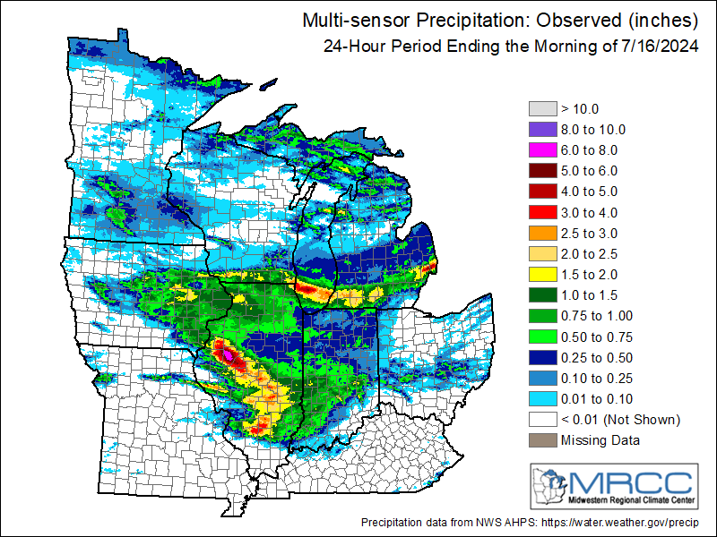 |
| Local Rain Map | Regional Rainfall Map Courtesy MRCC |
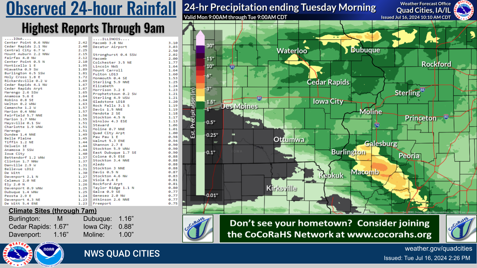
| 24 hour precipitation reports (in Inches), for eastern Iowa, northwest and west central Illinois, and northeast Missouri. Reported between Midnight and 9 AM, Tuesday July 16, 2024. |
|
| ....IOWA.... Center Point 0.6 NNW 2.42 Cedar Rapids 2.1 NW 2.40 Central City 6.7 W 2.25 Mount Auburn 2.2 NNW 2.15 Fairfax 4.0 NW 2.12 Center Point 0.5 N 2.10 Stanley 2.00 Monticello 1 E 1.95 Hiawatha 0.9 SW 1.89 Burlington 6.5 SSW 1.81 Holy Cross 1.8 E 1.72 Rickardsville 0.2 W 1.69 Cedar Rapids 4.1 NW 1.67 Cedar Rapids Arpt 1.67 Marengo 2.6 SSW 1.65 Anamosa 5.6 E 1.64 Robins 0.8 SE 1.64 Welton 0.2 WNW 1.63 Oelwein AWOS 1.63 Camanche 1.2 W 1.57 Marion 0.4 NNW 1.57 Fairfield 5.7 NNE 1.56 Marion 1.7 NNW 1.55 Maysville 0.1 SW 1.51 Charlotte 1.9 WNW 1.51 Marengo 1.51 Dundee 1.4 NNE 1.49 Lowden 1.48 Burlington 2S 1.46 Belle Plaine 1.45 Tiffin 1.2 NE 1.44 Oelwein 1E 1.44 Anamosa 3 SSW 1.44 Iowa City 1.40 Bettendorf 1.2 WNW 1.37 Clinton 1.7 NNW 1.37 Danville 2.9 W 1.31 Bellevue LD12 1.31 De Witt 1.30 Davenport 2.1 N 1.27 Calamus 2.0 NE 1.26 Ely 2.0 N 1.26 Toledo 2.8 N 1.26 Davenport 0.9 WNW 1.25 Dubuque 1.4 WNW 1.25 Peosta 2.9 E 1.24 Davenport 4.3 NE 1.23 De Witt 5.4 ENE 1.23 Nichols 2.5 NNW 1.21 Asbury 0.4 SW 1.19 Wapello 5.4 SE 1.18 Ely 0.5 SE 1.18 Dubuque #3 7 SW 1.16 Davenport Arpt 1.16 Dubuque Arpt 1.16 Washington 1.15 Eldridge 0.6 S 1.12 Eldridge 0.7 SSW 1.11 Yarmouth 1.9 SW 1.10 Clarence 3.9 S 1.09 Iowa City 2.3 E 1.09 Strawberry Point 1.09 Sigourney 1.08 Wellman 4.0 E 1.07 Fort Madison 7.7 N 1.06 Dubuque LD11 1.05 Bellevue 12.2 NW 1.03 Dyersville 1.7 ESE 1.03 Park View 0.2 WSW 1.00 Marshalltown 1.3 NW 1.00 Salem 3.1 ESE 0.98 Morning Sun 1.7 E 0.98 Le Claire 2.0 WSW 0.98 Shellsburg 2.9 S 0.98 Riverdale 0.5 N 0.97 Independence 0.6 ESE 0.96 Parnell 0.1 SSW 0.95 Hayesville 0.2 SW 0.93 Iowa City 2.7 E 0.93 Dubuque 1.0 SE 0.93 Solon 0.4 WNW 0.92 West Branch 2.3 SSW 0.90 Williamsburg 0.90 Columbus Jct 2 SSW 0.90 North English 0.89 Tipton 0.7 N 0.88 Iowa City Arpt 0.88 Vinton 3.6 SE 0.86 Tipton 0.3 ESE 0.85 Solon 0.3 ESE 0.85 Iowa City 2.8 WSW 0.83 Salem 1S 0.80 Ainsworth 7.4 N 0.72 Waterloo ASOS 5.2 NW 0.71 Tipton 6.9 SSW 0.69 Vinton 0.65 Manchester 0.65 West Point 7.5 NW 0.64 Hillsboro 5.8 SE 0.56 Grinnell 2.3 SW 0.56 Muscatine 2.1 N 0.52 Fairfield 0.52 Muscatine 1.7 N 0.51 Muscatine 1.4 N 0.50 Muscatine 2N 0.49 Pella AWOS 1.5 WSW 0.47 Grinnell AWOS 2.4 SSW 0.46 Hopkinton 5.4 WSW 0.43 Fairfield 0.7 SE 0.40 Boone 1.3 SSW 0.39 Pella 4 N 0.38 Fort Madison 4.5 NNW 0.36 Fort Madison 0.9 NE 0.34 NWS Johnston* 4.6 NNW 0.34 Elkader 6SSW 0.32 Guttenberg Dam 10 0.30 Ames US 30 2.2 SE 0.30 Muscatine 3.0 NE 0.27 Oskaloosa AWOS 9.2 ESE 0.22 Hampton 1 N 0.12 Bloomfield 1.4 NW 0.10 Farmington 3.5 W 0.07 Farmington 2.4 W 0.06 Mason City ASOS 6.3 W 0.06 Farmington 0.3 NW 0.05 Fayette 1 NW 0.05 Donnellson 0.05 Farmington 0.4 NNW 0.04 Keokuk LD19 0.01 Ottumwa ASOS 5.8 NNW 0.00 Keokuk 3.4 NW 0.00 Rathbun Reservoir 1.6 N 0.00 Mason City 0.9 NNE 0.00 Centerville 0.3 NE 0.00 |
....ILLINOIS.... Prairie City 2S 4.91 Macomb 3.8 NW 3.10 Decatur Airport 3.03 Pittsfield 2.79 Windsor 2.17 Stronghurst 0.4 SSW 2.02 Macomb 2.00 Colchester 3.5 NE 1.77 Lincoln NWS 1.64 Mount Carroll 1.64 Fulton LD13 1.60 Monmouth 0.4 SE 1.53 Sterling 5.9 NNE 1.25 Elizabeth 1.24 Morrison 3.2 E 1.23 Prophetstown 0.2 SW 1.21 Sterling 4.9 WSW 1.21 Gladstone LD18 1.20 Rock Falls 3.1 S 1.19 Davis 1.5 NNE 1.19 Mendota 2 SE 1.18 Stockton 4.5 N 1.17 Tuscola 1.15 Winslow 4.3 ESE 1.13 Steward 1.06 Galesburg 1.02 Moline 0.7 NNE 1.01 Quad City Arpt 1.00 Paw Paw 1 E 0.98 Walnut 5.3 ENE 0.94 Shannon 2.7 E 0.90 Stockton 5.9 WNW 0.90 East Dubuque 1.7 SE 0.90 Colona 0.5 ESE 0.88 Stockton 3.4 NNE 0.88 Aledo 0.88 Stockton 3 NNE 0.88 Davis 0.5 N 0.87 La Harpe 0.86 Stockton 4.6 NW 0.83 Viola 0.4 E 0.81 Rockford Arpt 0.81 Taylor Ridge 1.1 N 0.80 Galva 0.9 SE 0.77 Geneseo 2.0 NW 0.77 Atkinson 2.6 NNE 0.77 Freeport 0.75 Ottawa 4 SW 0.75 New Boston LD17 0.72 Ill. City LD16 3 WNW 0.70 New Windsor 2.0 N 0.68 Ogden 0.67 Bentley 0.67 Rochelle Arpt 0.66 Freeport 4.3 W 0.65 Romeoville 0.64 Jacksonville 2E 0.62 McNabb 1.4 NW 0.59 Illinois City 6.7 SW 0.55 Freeport 2.9 WSW 0.47 St Anne 0.47 Dallas City 3.0 SSE 0.39 Bloomington Airport 0.29 Augusta 0.26 |
Environment
Storm Prediction Center Outlooks
 |
 |
 |
 |
| SPC Day 1 2000z Outlook |
Tornado Risk Probabilities
|
Severe Wind Risk Probabilities **Sig Severe Likely** |
Severe Hail Risk Probabilities
|
Watches and Mesoscale Discussions
 |
 |
 |
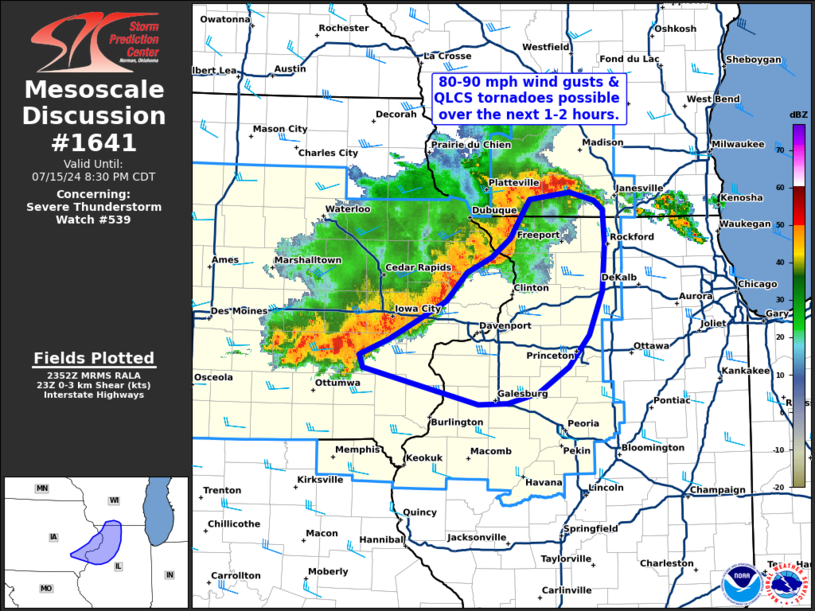 |
| Severe Watch #539 | Tornado Watch #541 | Mesoscale Discussion #1630 | Mesoscale Discussion #1641 |
Local Soundings at DVN
 |
 |
| 07/15/2024 - 7:00 am | 07/15/2024 - 2:00 pm |
Synoptic Environment
 |
 |
 |
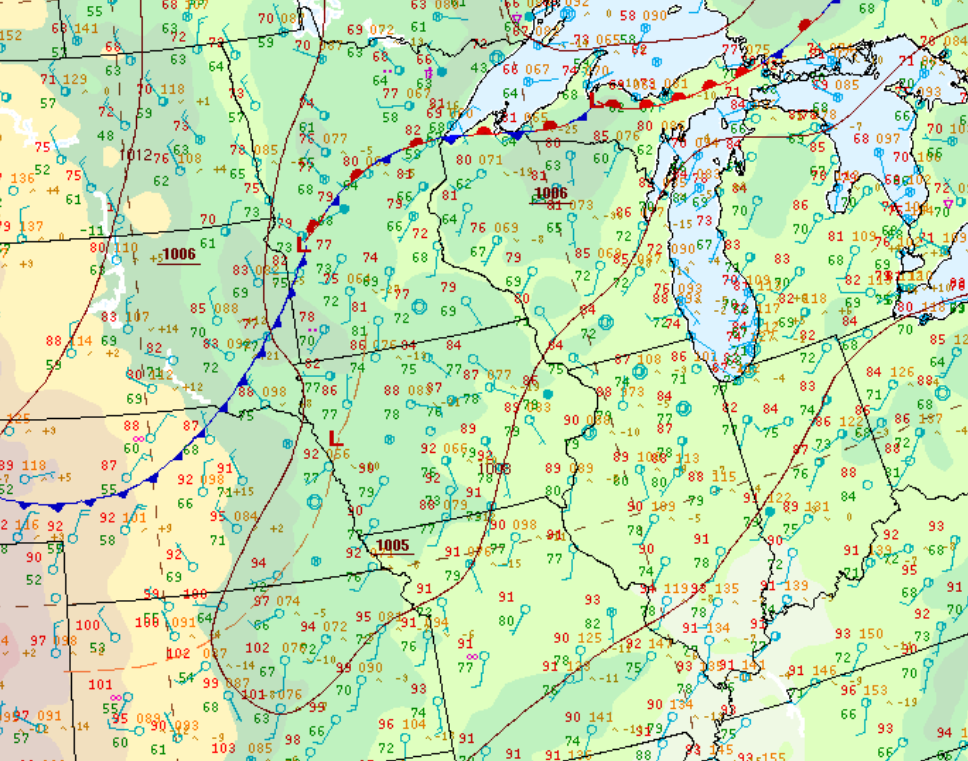 |
| 500 mb Chart at 4pm | 700 mb Chart at 4pm | 850 mb Chart at 4pm | Surface Chart at 1pm |
Mesoscale Environment
 |
 |
 |
 |
|
0-6 km Wind Shear Favorable for Organized Convection |
Instability Favorable for Organized Convection |
Precipitable Water Favorable for Heavy Rain |
Downdraft CAPE Favorable for Strong Downdrafts |
 |
Media use of NWS Web News Stories is encouraged! Please acknowledge the NWS as the source of any news information accessed from this site. |
|


.gif)