Scattered severe thunderstorms capable of damaging wind gusts and some hail are expected this afternoon and evening from the Upper Ohio River Valley into the Northeast, and from the Appalachians into the Mid-Atlantic States. Excessive rainfall from heavy thunderstorms may produce areas of flash flooding from southern New Mexico into the western and northern Gulf Coast into Wednesday. Read More >
Overview
|
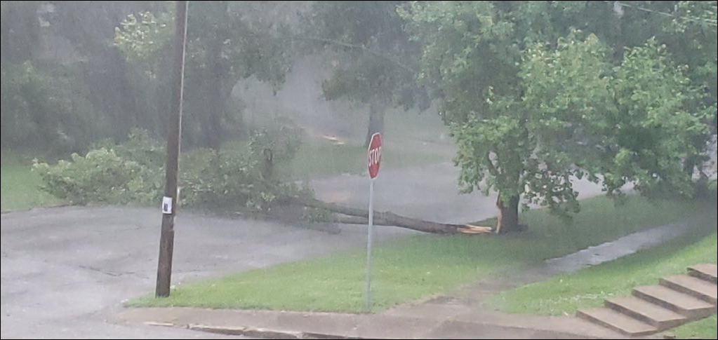
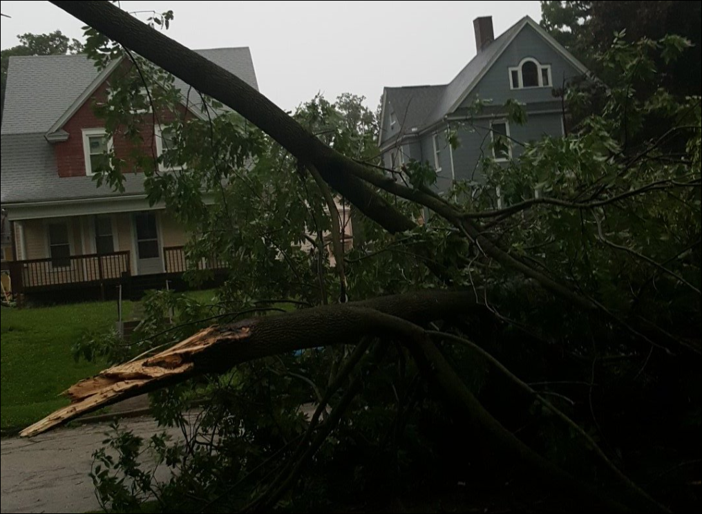
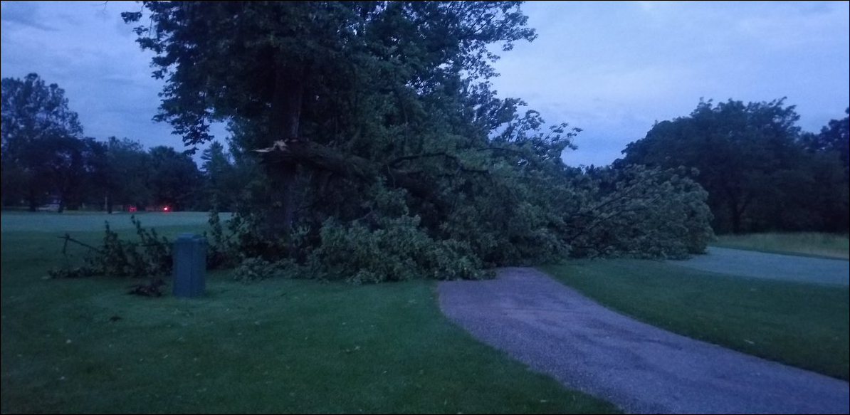
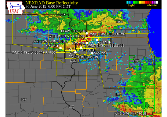
A line of thunderstorms tracked southeast across northeast Iowa into eastern Iowa and northwest Illinois during the afternoon and evening of Sunday, June 30, 2019, bringing widespread downed trees and power lines as 50-70 mph winds rolled through. The strongest winds were recorded in Dubuque County, where a wind gust of 76 mph was observed at the Dubuque Regional Airport. Several hometowns were without power after the storms passed. *********************************************************************************************** A storm survey team assessed damage in Dubuque county and found three swaths of 70-90 mph winds, with isolated 100 mph. Numerous farm buildings and trees were destroyed along the paths. The approximate path areas were from Epworth to Fillmore, 3 N of Bernard to Bernard, and Asbury to Dubuque. An anchored mobile home was destroyed 4 S of Epworth with 2 injuries. Further southeast along the Epworth to Fillmore track, a home lost its roof. Another injury occurred near Bernard at 14029 Ryan Rd, where a barn was partially destroyed and trees snapped off. All injuries were not life threatening. |
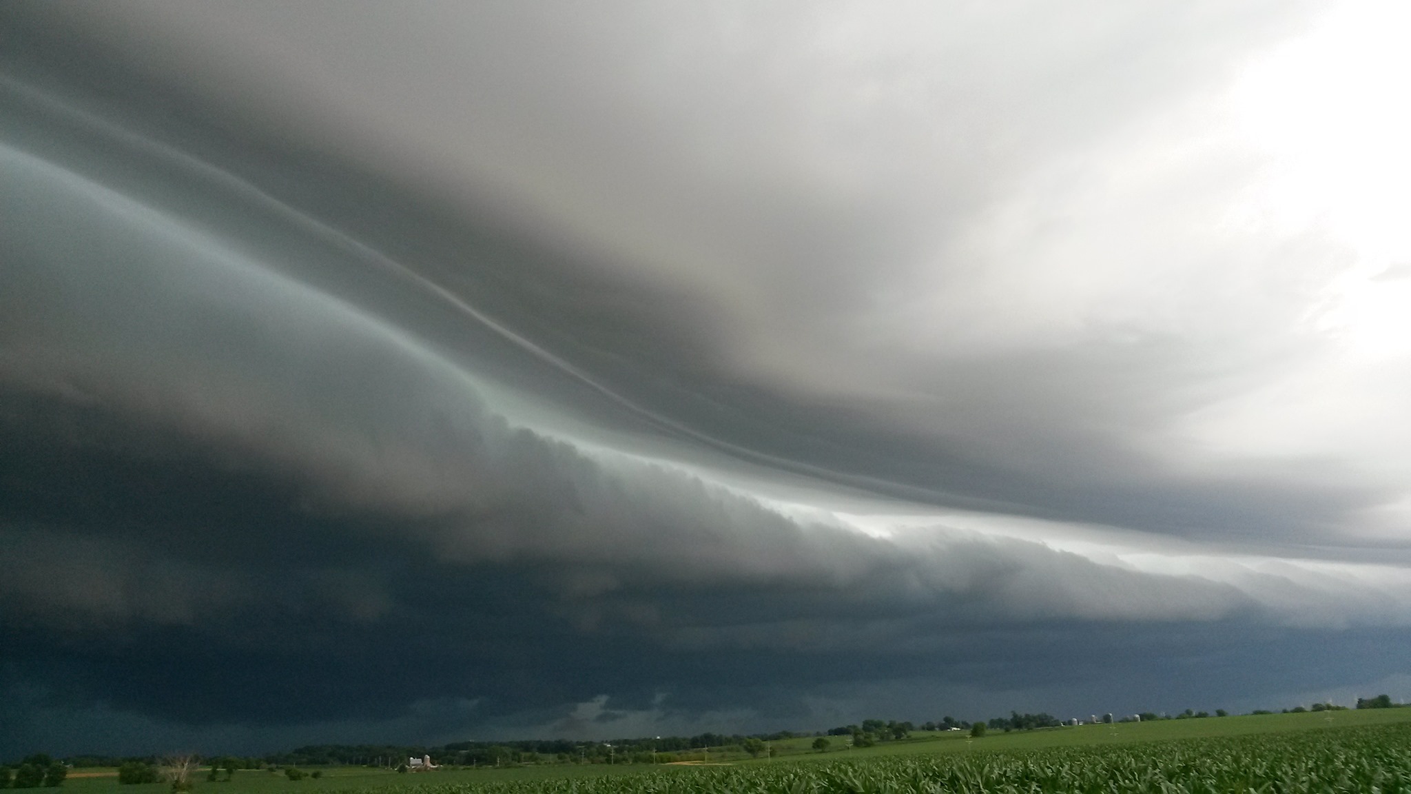 Stockton, IL Photo: Fred Demeter |
||||||||
|
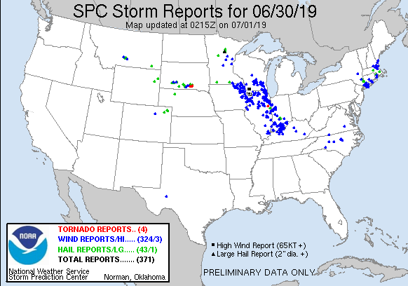
Storm Reports
| Interactive Storm Report Map | SPC Storm Reports |
 |
 |
PRELIMINARY LOCAL STORM REPORT...SUMMARY
NATIONAL WEATHER SERVICE QUAD CITIES IA IL
909 PM CDT SUN JUN 30 2019

..TIME...   ...EVENT...      ...CITY LOCATION...     ...LAT.LON...
..DATE...   ....MAG....      ..COUNTY LOCATION..ST.. ...SOURCE....
            ..REMARKS..

0112 PM     HAIL             PEARL CITY              42.27N 89.83W
06/30/2019  E0.25 INCH       STEPHENSON         IL   PUBLIC

            VIA FACEBOOK.

0452 PM     TSTM WND GST     4 W STANLEY             42.63N 91.86W
06/30/2019  M59 MPH          BUCHANAN           IA   CO-OP OBSERVER


0501 PM     TSTM WND DMG     S EDGEWOOD              42.64N 91.40W
06/30/2019                   DELAWARE           IA   EMERGENCY MNGR

            REPORTED NUMEROUS TREES DOWN IN EDGEWOOD.

0502 PM     TSTM WND DMG     1 S HAZLETON            42.60N 91.91W
06/30/2019                   BUCHANAN           IA   TRAINED SPOTTER

            CORRECTS PREVIOUS TSTM WND DMG REPORT FROM 1
            S HAZLETON. LARGE TREE LIMB DOWN IN FONTANA
            PARK. TWO FOOT DIAMETER TREE DOWN IN THE
            PARK WITH NUMEROUS OTHER TREES DOWN.

0507 PM     TSTM WND DMG     DUNDEE                  42.58N 91.55W
06/30/2019                   DELAWARE           IA   EMERGENCY MNGR

            NUMEROUS TREES DOWN IN TOWN, TIME ESTIMATED
            FROM RADAR.

0509 PM     TSTM WND GST     1 E INDEPENDENCE        42.47N 91.88W
06/30/2019  M56 MPH          BUCHANAN           IA   TRAINED SPOTTER


0510 PM     TSTM WND DMG     INDEPENDENCE            42.47N 91.89W
06/30/2019                   BUCHANAN           IA   TRAINED SPOTTER

            CORRECTS PREVIOUS TSTM WND DMG REPORT FROM
            INDEPENDENCE. NUMEROUS REPORTS OF BRANCHES
            DOWN SOME AS LARGE AS 5 INCHES IN DIAMETER.
            A COUPLE REPORTS OF TREES ABOUT 12 TO 24
            INCHES IN DIAMETER SNAPPED OFF 3 FEET OFF
            THE GROUND.

0511 PM     TSTM WND DMG     EARLVILLE               42.48N 91.27W
06/30/2019                   DELAWARE           IA   EMERGENCY MNGR

            ROOF BLOW OFF A HOUSE IN TOWN.

0517 PM     TSTM WND DMG     NEW VIENNA              42.55N 91.11W
06/30/2019                   DUBUQUE            IA   EMERGENCY MNGR

            TREE LIMBS DOWN IN TOWN.

0517 PM     TSTM WND GST     NEW VIENNA              42.55N 91.11W
06/30/2019  E60 MPH          DUBUQUE            IA   EMERGENCY MNGR


0518 PM     TSTM WND DMG     1 N MASONVILLE          42.50N 91.59W
06/30/2019                   DELAWARE           IA   EMERGENCY MNGR

            LARGE TREE DOWN BLOCKING RURAL ROAD NORTH OF
            MASONVILLE.

0530 PM     TSTM WND DMG     PEOSTA                  42.45N 90.85W
06/30/2019                   DUBUQUE            IA   TRAINED SPOTTER

            NUMEROUS TREE LIMBS DOWN. SOME 4 INCHES.

0540 PM     TSTM WND DMG     1 N PARK VIEW           41.70N 90.54W
06/30/2019                   SCOTT              IA   PUBLIC

            1 TREE UPROOTED AND ACROSS ROAD NEAR 27240
            183RD AVE. TIME ESTIMATED FROM RADAR.

0542 PM     TSTM WND DMG     OTTER CREEK             42.24N 90.68W
06/30/2019                   JACKSON            IA   AMATEUR RADIO

            TWO SHEDS BLOWN OVER IN TOWN. TIME ESTIMATED
            USING RADAR.

0542 PM     TSTM WND DMG     2 E LUXEMBURG           42.60N 91.04W
06/30/2019                   DUBUQUE            IA   DEPT OF HIGHWAYS

            POWER LINES DOWN BETWEEN LUXEMBURG AND HOLY
            CROSS.

0544 PM     TSTM WND GST     DUBUQUE REGIONAL ARPT   42.40N 90.71W
06/30/2019  M76 MPH          DUBUQUE            IA   ASOS


0545 PM     TSTM WND GST     2 NE MARION             42.05N 91.56W
06/30/2019  E65 MPH          LINN               IA   TRAINED SPOTTER


0547 PM     TSTM WND DMG     4 NW GALENA             42.46N 90.47W
06/30/2019                   JO DAVIESS         IL   TRAINED SPOTTER

            LARGE TREE LIMB DOWN, 9-12 INCH IN DIAMETER.

0549 PM     TSTM WND DMG     2 W CEDAR RAPIDS        41.97N 91.71W
06/30/2019                   LINN               IA   TRAINED SPOTTER

            NUMEROUS TREE LIMBS SOME 4 INCHES IN
            DIAMETER.

0554 PM     TSTM WND DMG     OLIN                    42.00N 91.14W
06/30/2019                   JONES              IA   TRAINED SPOTTER

            ROOFS RIPPED OFF MULTIPLE BUILDINGS IN TOWN.

0555 PM     TSTM WND DMG     2 NNE OLIN              42.02N 91.13W
06/30/2019                   JONES              IA   MESONET


0556 PM     TSTM WND DMG     OXFORD JUNCTION         41.98N 90.95W
06/30/2019                   JONES              IA   TRAINED SPOTTER

            NUMEROUS TREE BRANCHES DOWN, TIME ESTIMATED
            FROM RADAR.

0602 PM     TSTM WND DMG     1 N BELLEVUE            42.27N 90.43W
06/30/2019                   JACKSON            IA   DEPT OF HIGHWAYS

            TREES DOWN ON HIGHWAY 52 NEAR BELLEVUE.

0603 PM     TSTM WND DMG     ELIZABETH               42.32N 90.23W
06/30/2019                   JO DAVIESS         IL   TRAINED SPOTTER

            8 INCH DIAMETER WINDS.

0604 PM     TSTM WND GST     1 WNW MAQUOKETA         42.07N 90.68W
06/30/2019  M60 MPH          JACKSON            IA   MESONET

            MEASURED AT RWIS IADOT.

0605 PM     TSTM WND GST     BELLEVUE                42.26N 90.43W
06/30/2019  E75 MPH          JACKSON            IA   TRAINED SPOTTER

            LOCATED ON THE HILL IN TOWN.

0608 PM     TSTM WND DMG     TIPTON                  41.77N 91.13W
06/30/2019                   CEDAR              IA   TRAINED SPOTTER

            NUMEROUS TREE DAMAGE IN TOWN.

0608 PM     TSTM WND DMG     MAQUOKETA               42.06N 90.67W
06/30/2019                   JACKSON            IA   TRAINED SPOTTER

            NUMEROUS TREE LIMBS DOWN AND SMALL DEBRIS IN
            THE AIR. MOST LIMBS WERE 2 TO 4 INCHES IN
            DIAMETER.

0610 PM     TSTM WND GST     1 N LOWDEN              41.87N 90.92W
06/30/2019  E60 MPH          CEDAR              IA   CO-OP OBSERVER

            5 MINUTES OF 50 TO 60 MPH WINDS.

0611 PM     TSTM WND GST     2 ESE CLINTON           41.83N 90.20W
06/30/2019  M65 MPH          CLINTON            IA   TRAINED SPOTTER


0613 PM     TSTM WND DMG     MONTICELLO              42.24N 91.19W
06/30/2019                   JONES              IA   EMERGENCY MNGR

            WIDESPREAD THUNDERSTORM WIND DAMAGE ACROSS
            JONES COUNTY WITH NUMEROUS TREE DOWNS AND
            LIMBS THROUGHT THE COUNTY. A ROOF BLOWN OFF
            A SHED IN OLIN.

0614 PM     TSTM WND GST     3 N STOCKTON            42.40N 90.00W
06/30/2019  M63 MPH          JO DAVIESS         IL   CO-OP OBSERVER


0620 PM     TSTM WND GST     3 S CEDAR RAPIDS        41.93N 91.68W
06/30/2019  M69 MPH          LINN               IA   MESONET

            IADOT SITE (RCII4).

0622 PM     TSTM WND GST     2 W DIXON               41.74N 90.82W
06/30/2019  M67 MPH          SCOTT              IA   TRAINED SPOTTER


0632 PM     TSTM WND DMG     SAVANNA                 42.09N 90.14W
06/30/2019                   CARROLL            IL   EMERGENCY MNGR

            TREES AND POWER LINES DOWN.

0632 PM     TSTM WND GST     MOUNT CARROLL           42.10N 89.98W
06/30/2019  E65 MPH          CARROLL            IL   EMERGENCY MNGR

            DELAYED REPORT.

0632 PM     TSTM WND DMG     MOUNT CARROLL           42.10N 89.98W
06/30/2019                   CARROLL            IL   EMERGENCY MNGR

            TREES AND POWER LINES DOWN.

0632 PM     TSTM WND GST     4 SSE MAYSVILLE         41.60N 90.68W
06/30/2019  M62 MPH          SCOTT              IA   MESONET


0634 PM     TSTM WND GST     DAVENPORT MUNICIPALITY  41.61N 90.58W
06/30/2019  E49 MPH          SCOTT              IA   MESONET

            RSOIS AT NWS OFFICE.

0636 PM     TSTM WND DMG     1 N PARK VIEW           41.70N 90.54W
06/30/2019                   SCOTT              IA   PUBLIC

            CORRECTS PREVIOUS TSTM WND DMG REPORT FROM 1
            N PARK VIEW. FENCE RIPPED OUT AND PATIO
            THROWN INTO A POOL. REPORTED AT 18360 272ND
            S.

0636 PM     TSTM WND GST     DAVENPORT MUNICIPALITY  41.61N 90.59W
06/30/2019  E52 MPH          SCOTT              IA   ASOS


0637 PM     TSTM WND DMG     PARK VIEW               41.69N 90.54W
06/30/2019                   SCOTT              IA   NWS EMPLOYEE

            3 INCH DIAMETER TREE LIMBS DOWN.

0638 PM     TSTM WND DMG     1 SSE DAVENPORT         41.55N 90.60W
06/30/2019                   SCOTT              IA   TRAINED SPOTTER

            LARGE TREE BRANCH DOWN ON HOUSE AT 1624 WEST
            COLUMBIA AVE.

0639 PM     TSTM WND GST     IOWA CITY MUNICIPALITY  41.64N 91.55W
06/30/2019  M54 MPH          JOHNSON            IA   ASOS


0640 PM     TSTM WND DMG     DAVENPORT               41.56N 90.61W
06/30/2019                   SCOTT              IA   PUBLIC

            10 TO 12 INCH TREE BROKEN OFF ABOVE THE BASE AND
            IT FELL ONTO A HOME. TIME OF THE EVENT
            ESTIMATING USING RADAR.

0643 PM     TSTM WND DMG     MUSCATINE               41.42N 91.07W
06/30/2019                   MUSCATINE          IA   EMERGENCY MNGR

            SEVERAL TREE LIMBS AND POWER LINES DOWN
            THROUGHOUT THE TOWN. TIME ESTIMATED FROM
            RADAR.

0644 PM     TSTM WND DMG     2 SW ROCK ISLAND        41.46N 90.60W
06/30/2019                   ROCK ISLAND        IL   TRAINED SPOTTER

            2 TO 3 INCH TREE LIMBS DOWN AND THE POWER IS
            OUT. TIME ESTIMATED USING RADAR.

0644 PM     TSTM WND DMG     3 ENE MUSCATINE         41.44N 91.03W
06/30/2019                   MUSCATINE          IA   TRAINED SPOTTER

            NUMEROUS TREE LIMBS DOWN 2 TO 4 INCHES IN
            DIAMETER. ONE DENTED A CAR.

0644 PM     TSTM WND DMG     LANARK                  42.10N 89.83W
06/30/2019                   CARROLL            IL   EMERGENCY MNGR

            TREES AND POWER LINES DOWN. DELAYED REPORT.

0645 PM     TSTM WND DMG     1 SSE DAVENPORT         41.54N 90.60W
06/30/2019                   SCOTT              IA   TRAINED SPOTTER

            8-10 INCH DIAMETER BRANCHES DOWN; 1.7 INCHES
            OF RAIN.

0645 PM     TSTM WND DMG     BLUE GRASS              41.51N 90.76W
06/30/2019                   SCOTT              IA   PUBLIC

            SHED LOST.

0645 PM     TSTM WND DMG     1 W BETTENDORF          41.56N 90.49W
06/30/2019                   SCOTT              IA   TRAINED SPOTTER

            2-3 INCH TREE LIMBS DOWN; TIME ESTIMATED BY
            SPOTTER.

0648 PM     TSTM WND GST     1 ENE MONTPELIER        41.47N 90.78W
06/30/2019  M62 MPH          SCOTT              IA   TRAINED SPOTTER

            LOST 8-INCH DIAMETER TREE.

0650 PM     TSTM WND DMG     1 NW FREEPORT           42.31N 89.65W
06/30/2019                   STEPHENSON         IL   PUBLIC

            6 INCH TREE LIMB DOWN, REPORT VIA TWITTER,
            TIME ESTIMATED FROM RADAR.

0652 PM     TSTM WND GST     MOLINE QUAD-CITY AIRPOR 41.45N 90.51W
06/30/2019  M53 MPH          ROCK ISLAND        IL   ASOS


0657 PM     TSTM WND DMG     SHANNON                 42.15N 89.74W
06/30/2019                   CARROLL            IL   PUBLIC

            3 TO 6 INCH TREE LIMBS DOWN.

0722 PM     TSTM WND GST     4 NE MORRISTOWN         41.44N 90.25W
06/30/2019  E58 MPH          HENRY              IL   AMATEUR RADIO

            HANDHELD ANEMOMETER.

0724 PM     TSTM WND DMG     1 W GERLAW              40.99N 90.63W
06/30/2019                   WARREN             IL   TRAINED SPOTTER

            LARGE TREE UPROOTED. PHOTO VIA TWITTER.

0726 PM     TSTM WND DMG     1 SSW GALVA             41.15N 90.04W
06/30/2019                   HENRY              IL   EMERGENCY MNGR

            CORRECTS PREVIOUS TSTM WND DMG REPORT FROM 1
            SSW GALVA. TREE SNAPPED OFF AT THE BASE AND
            POWER LINES DOWN NEAR THIS LOCATION.

0726 PM     TSTM WND DMG     CAMBRIDGE               41.30N 90.20W
06/30/2019                   HENRY              IL   TRAINED SPOTTER

            SEVERAL SMALL TREE BRANCHES APPROX 3 INCH
            DIAMETER DOWN. POWER LINES DOWN.

0739 PM     TSTM WND GST     BURLINGTON REGIONAL AIR 40.78N 91.12W
06/30/2019  M58 MPH          DES MOINES         IA   ASOS


0748 PM     TSTM WND DMG     GRANVILLE               41.26N 89.23W
06/30/2019                   PUTNAM             IL   911 CALL CENTER

            TIME OF THE EVENT WAS ESTIMATED USING RADAR.
            POWER LINE DOWN IN GRANVILLE AND TREE DOWN
            ACROSS THE ROAD ON HIGHWAY 26 NEAR HENNEPIN.

0754 PM     TSTM WND DMG     LA HARPE                40.59N 90.97W
06/30/2019                   HANCOCK            IL   BROADCAST MEDIA

            POWER LINES DOWN IN THE LA HARPE AREA. TIME
            ESTIMATED BY RADAR. REPORT VIA WGEM.
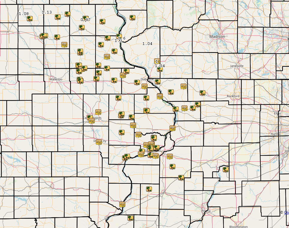
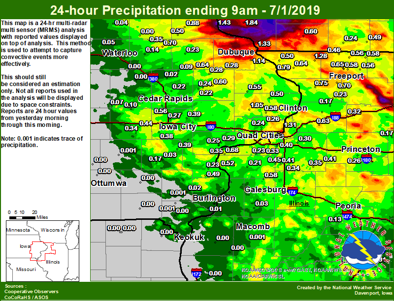
Rain Reports
| Local Rain Map | Regional Rainfall |
 |
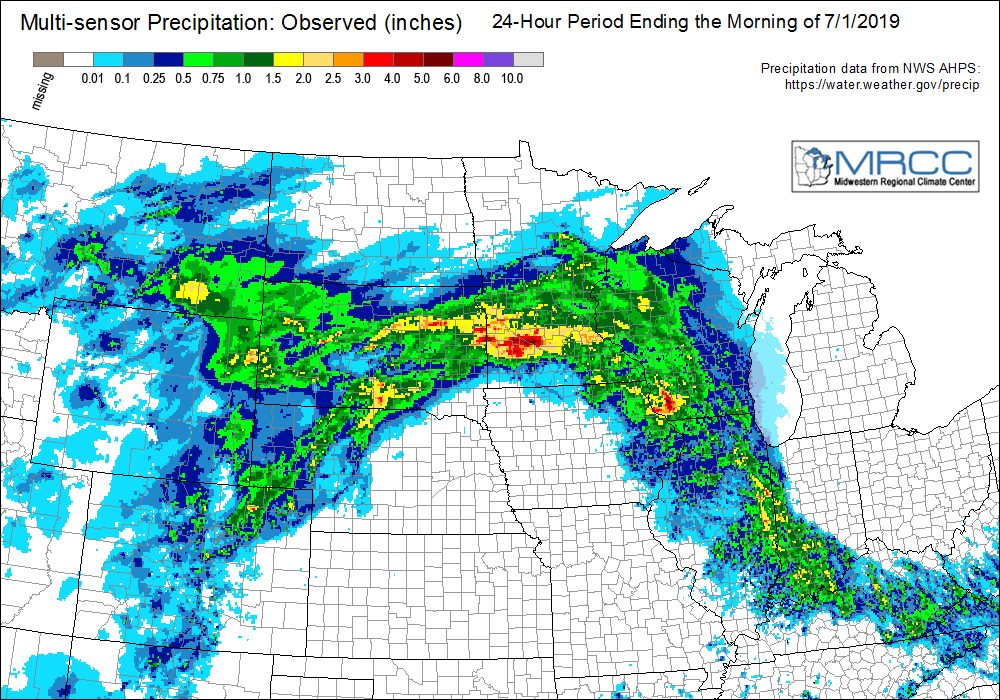 |
24 hour precipitation reports (in Inches), for eastern Iowa, northwest and west central Illinois, and northeast Missouri. Reported between Midnight and 9 AM, Monday July 01, 2019. ....IOWA.... Cresco 1 NE 1.66 Guttenberg Dam 10 1.43 Bettendorf 1.6 WSW 1.43 Davenport 0.9 WNW 1.40 Dubuque LD11 1.33 Davenport 0.9 SSW 1.32 Le Claire 1.8 NNE 1.31 Dubuque Arpt 7 SW 1.14 Calamus 2.0 NE 1.05 Elkader 6SSW 0.88 Riverdale 0.5 N 0.86 Bettendorf 2.2 SE 0.83 Bellevue LD12 0.79 Winthrop 5.6 NNE 0.70 Le Claire LD14 0.68 Hopkinton 5.4 WSW 0.64 Center Junction 2.6 W 0.60 De Witt 0.58 Camanche 1.2 W 0.56 Cedar Rapids Arpt 5 SW 0.56 Fayette 1 NW 0.55 Maquoketa 4 W 0.55 Charlotte 1.9 WNW 0.50 Strawberry Point 0.50 Morning Sun 1.7 E 0.49 Williamsburg 0.44 Davenport Arpt 5 N 0.42 Iowa City 8.0 NE 0.39 Ainsworth 7.4 N 0.39 Kalona 7.3 NNW 0.38 Stanley 0.35 Muscatine 1.4 N 0.35 Parnell 0.1 SSW 0.34 Muscatine 2N 0.29 Cascade 0.28 Monticello 1 E 0.28 North Liberty 0.7 SSW 0.27 Fairfax 4.0 NW 0.26 Park View 0.2 WSW 0.26 West Branch 2.0 NNW 0.26 Muscatine 2.1 N 0.25 Eldridge 0.7 SSW 0.24 Anamosa 1.9 SE 0.24 Iowa City 0.24 Wapello 0.2 S 0.23 Manchester 0.23 Anamosa 3 SSW 0.22 Marion 1.7 NNW 0.22 Iowa City Arpt 0.20 Cedar Rapids 2.7 NE 0.18 Washington 5.8 SW 0.17 Independence 0.9 WNW 0.14 Palo 4.4 SSW 0.14 Marengo 3.6 N 0.10 Coggon 0.09 Brighton 0.08 Belle Plaine 0.07 Solon 0.3 ESE 0.06 Waterloo ASOS 5 NW 0.05 Tripoli 0 N 0.04 Washington 0.03 Center Point 0.6 NNW 0.02 New London 1.5 SW 0.02 Hampton 1 N 0.02 Central City 6.7 W 0.02 Burlington 6.5 SSW 0.01 Toledo 3 N 0.00 Burlington Arpt 2 SW 0.00 Burlington 2.1 S 0.00 West Point 7.5 NW 0.00 Sigourney 0.00 Salem 3.1 ESE 0.00 Mason City ASOS 6 W 0.00 Rathbun Reservoir 2 N 0.00 Marshalltown ASOS 4 N 0.00 Pella 4 N 0.00 Marshalltown 1 NW 0.00 Perry 0 W 0.00 Ames US 30 2 SSE 0.00 Mount Auburn 2.2 NNW 0.00 Centerville 0 NE 0.00 Keosauqua 0.00 Newton 1 NE 0.00 Fairfield 0.00 Beaconsfield 1 NNE 0.00 NWS Johnston* 5 NNW 0.00 Ottumwa ASOS 6 NNW 0.00 Boone 1 SSW 0.00 Donnellson 0.00 Vinton 0.00 Grinnell AWOS 2 SSW 0.00 Tiffin 1.8 SW 0.00 Oskaloosa AWOS 9 ESE 0.00 Oelwein AWOS 0.00 Pella AWOS 2 WSW 0.00 ....ILLINOIS.... Joliet 1.36 Stockton 3.4 NNE 1.28 Steward 1.03 Rochelle AWOS 1.00 Rochelle 0.93 Mount Carroll 0.75 Orangeville 2.8 NW 0.75 Shannon 0.2 S 0.70 Illinois City 6.7 SW 0.68 Freeport 2.0 NW 0.65 Elizabeth 0.64 Prophetstown 0.2 SW 0.63 Alexis 1 SW 0.58 Davis 0.5 N 0.58 Freeport 1.7 NW 0.58 Ridott 0.1 NE 0.56 Dakota 4.8 NW 0.56 Mundelein 0.53 New Boston LD17 0.52 Galena 0.50 Winslow 4.3 ESE 0.46 New Windsor 2.0 N 0.45 Ottawa 4 SW 0.43 Alpha 2.3 N 0.41 Kewanee 1 E 0.41 Coal Valley 2.6 E 0.40 Princeton 1.1 SE 0.39 Freeport 0.39 Princeton 0.39 Galva 2.7 NE 0.35 Roscoe 2SE 0.35 Woodhull 0.3 ESE 0.34 Coal Valley 1.9 SE 0.33 Rock Falls 0.32 Romeoville 0.32 St Anne 0.32 Paw Paw 1 E 0.31 Geneseo 2.0 NW 0.30 Tiskilwa 2.1 N 0.26 Quad City Arpt 3 S 0.26 Milledgeville 0.6 NW 0.23 Milan 8.8 SSW 0.23 Aledo 0.21 Morrison 3.2 E 0.21 Decatur Airport 0.17 Mendota 2 SE 0.17 Coleta 1.4 SSW 0.17 Ill. City LD16 3 WNW 0.15 Galesburg Arpt 3 SW 0.14 Rockford ASOS 0.13 Peoria ASOS 0.13 Roseville 0.6 WNW 0.03 Bloomington Airport 0.02 Lincoln NWS 0.01 Jacksonville AWOS 0.01 Colchester 3.5 NE 0.00 Bentley 0.00 Augusta 0.00 Quincy ASOS 0.00 ....MISSOURI.... Memphis 0.00 Memphis 0.1 S 0.00 Kirksville ASOS 0.00 Kahoka 0.6 S 0.00 Chillicothe 2 NW 0.00 Columbia 0.00 ....WISCONSIN.... Lancaster 4WSW 1.84 Prairie du Chien AWOS 1.84 Viroqua 1.25 Madison-ASOS 0.85 La Crosse WFO 0.74 Steuben 4SE 3 NE 0.68 Darlington 0.60 Brodhead 1 SW 0.49 Allenton-WWTP .6 NW 0.39 Whitewater 0.28 Beloit-College 0.27 Monroe 1 W 0.24 Watertown-AWOS 0.00 ....MINNESOTA.... Theilman 1SSW 0.41 Preston 0.20 |
|
Environment
SPC Convective Outlooks
 |
 |
 |
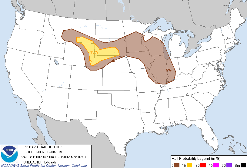 |
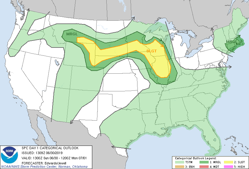
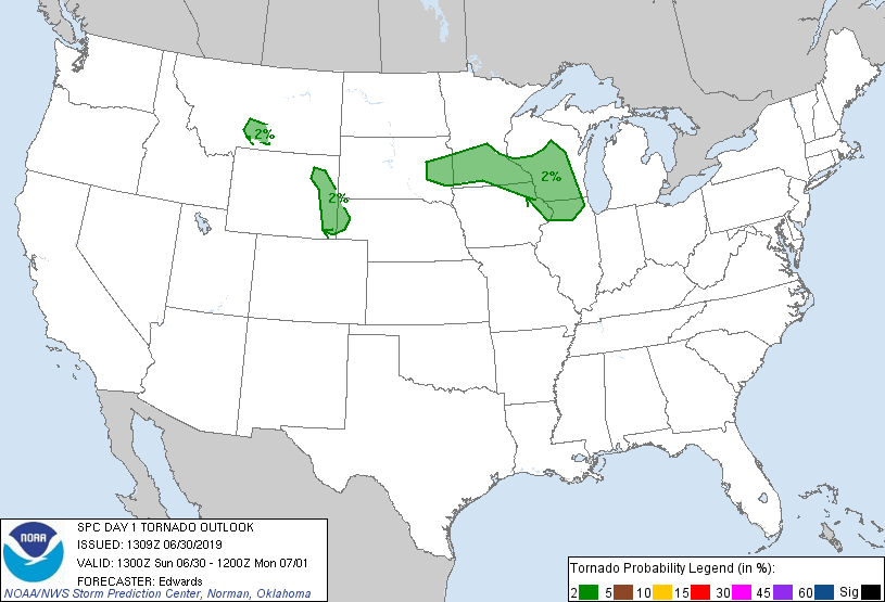
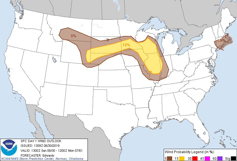
| SPC Day 1 Outlook (1300z) | SPC Day 1 Tornado Outlook (1300z) | SPC Day 1 Wind Outlook (1300z) | SPC Day 1 Hail Outlook (1300z) |
Local Sounding Analysis
 |
 |
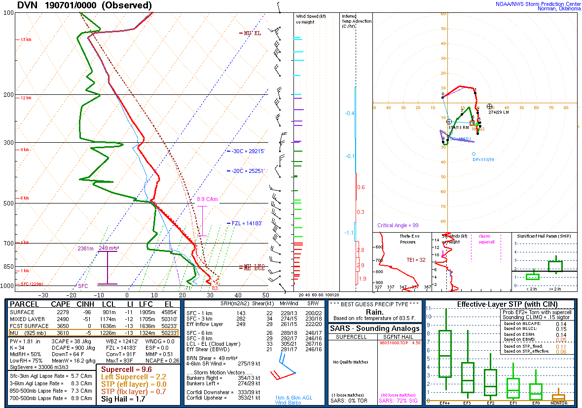 |
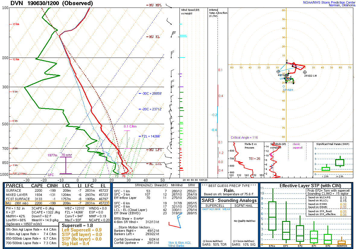
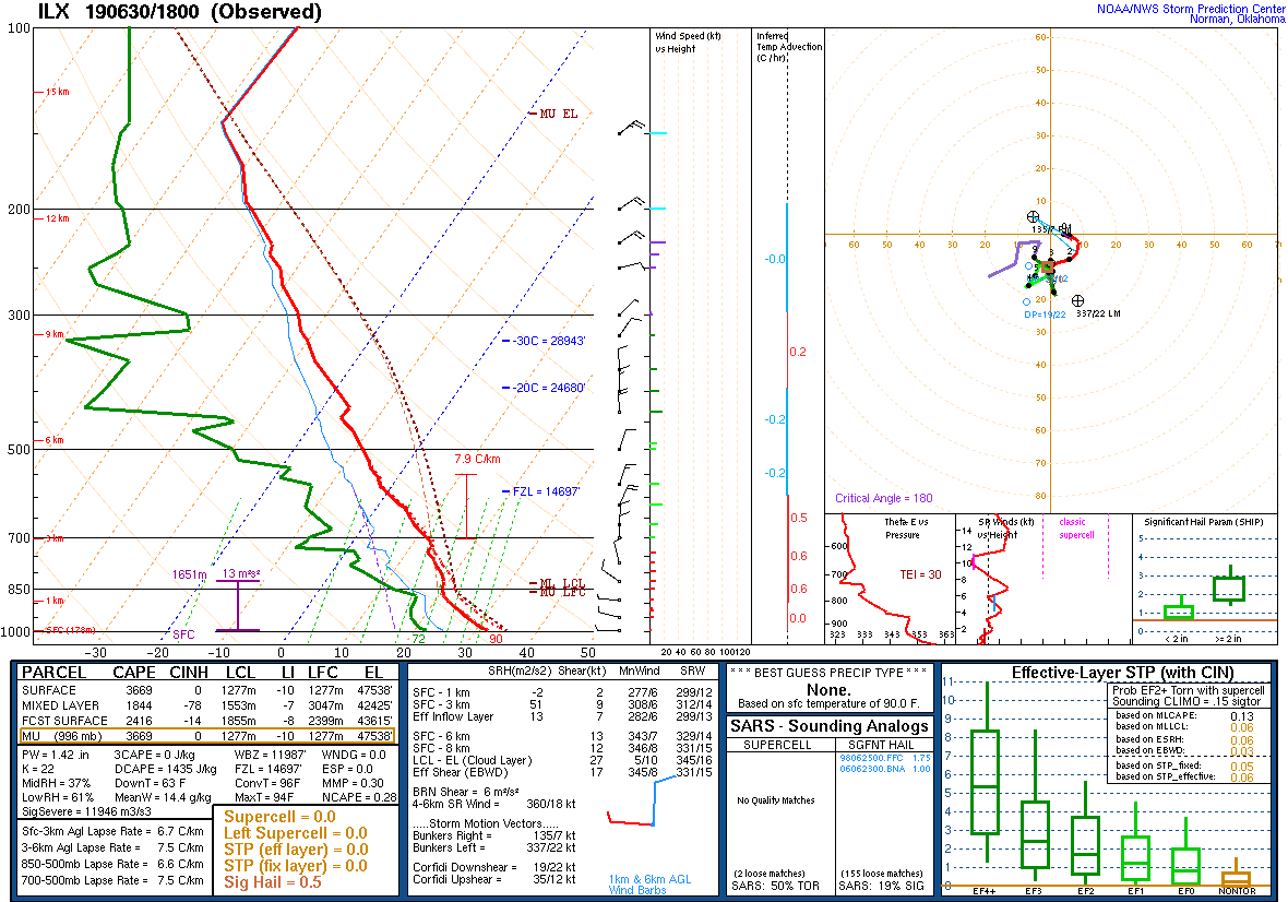
| DVN Sounding 6/30/19 12z | ILX Sounding 6/30/19 18z | DVN Sounding 7/1/19 00z |
SPC Watches Issued For Our Area
 |
 |
|
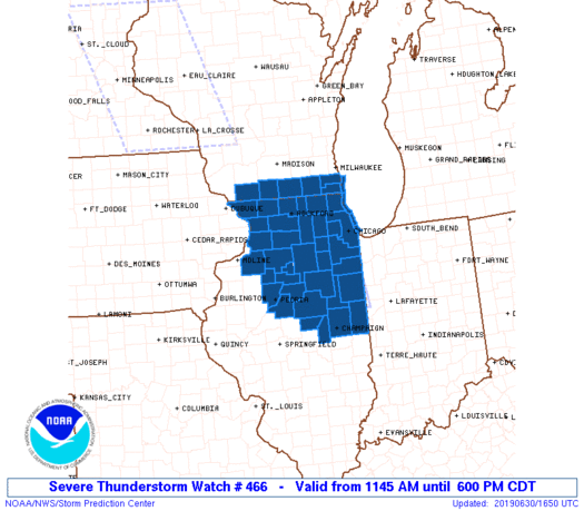
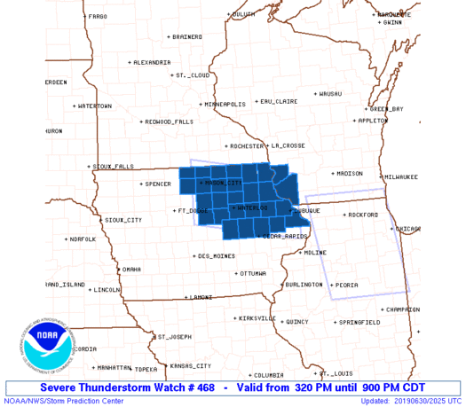
| SPC Severe Thunderstorm Watch #466 (see link for more details) | SPC Severe Thunderstorm Watch #468 (see link for more details) |
SPC Mesoscale Discussions Issued For Our Area
 |
 |
|||
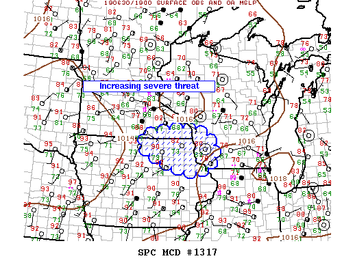
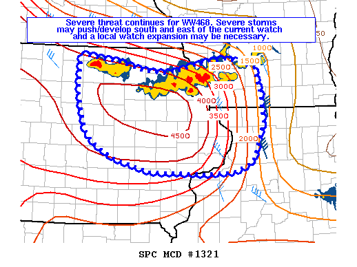
| SPC Mesoscale Discussion #1317 (see link for more details) | SPC Mesoscale Discussion #1321 (see link for more details) |
SPC - Storm Prediction Center
WPC - Weather Prediction Center
 |
Media use of NWS Web News Stories is encouraged! Please acknowledge the NWS as the source of any news information accessed from this site. |
|