Scattered severe thunderstorms capable of damaging wind gusts and some hail are expected this afternoon and evening from the Upper Ohio River Valley into the Northeast, and from the Appalachians into the Mid-Atlantic States. Excessive rainfall from heavy thunderstorms may produce areas of flash flooding from southern New Mexico into the western and northern Gulf Coast into Wednesday. Read More >
Overview
|
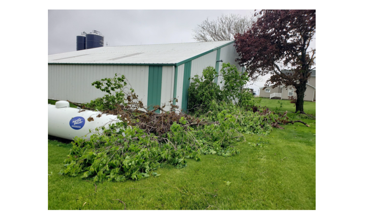
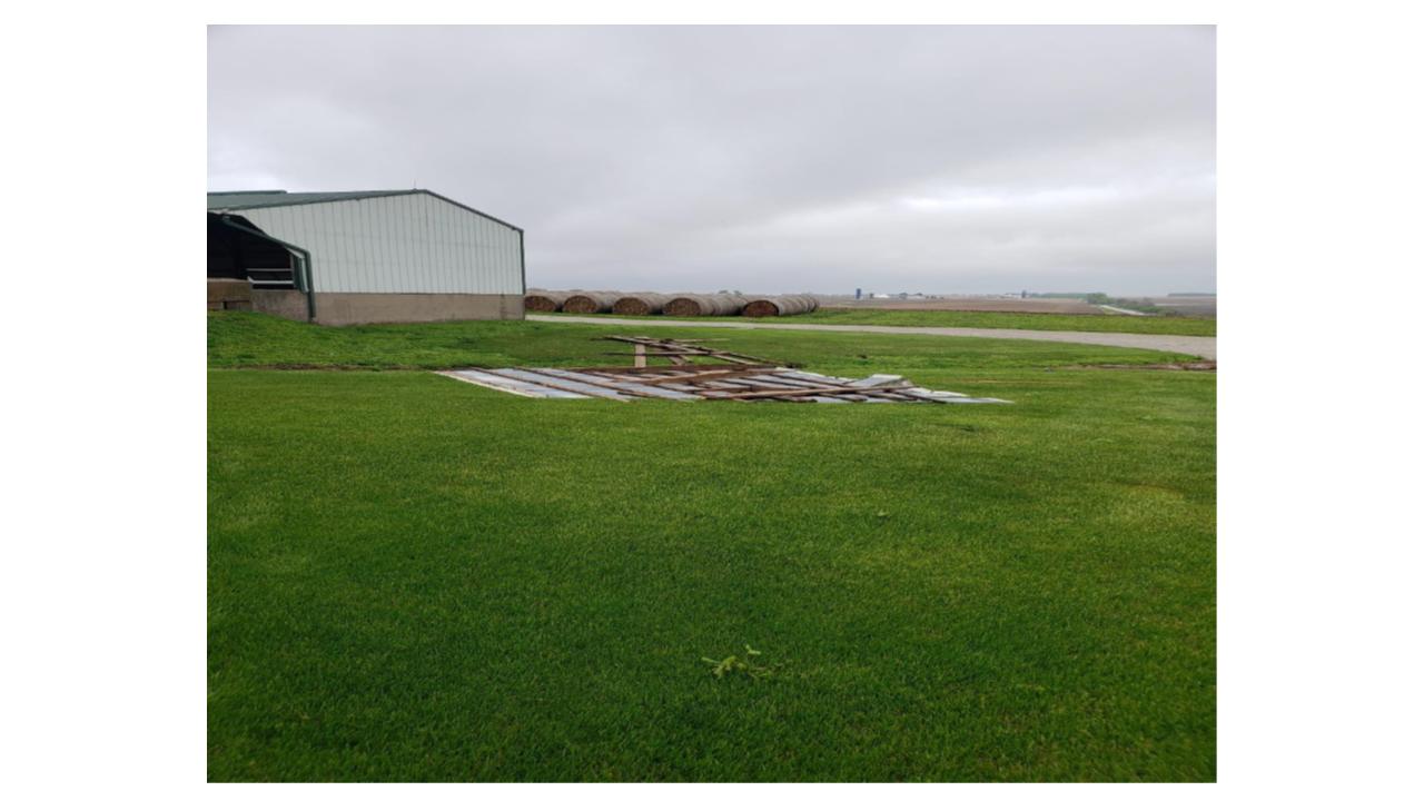
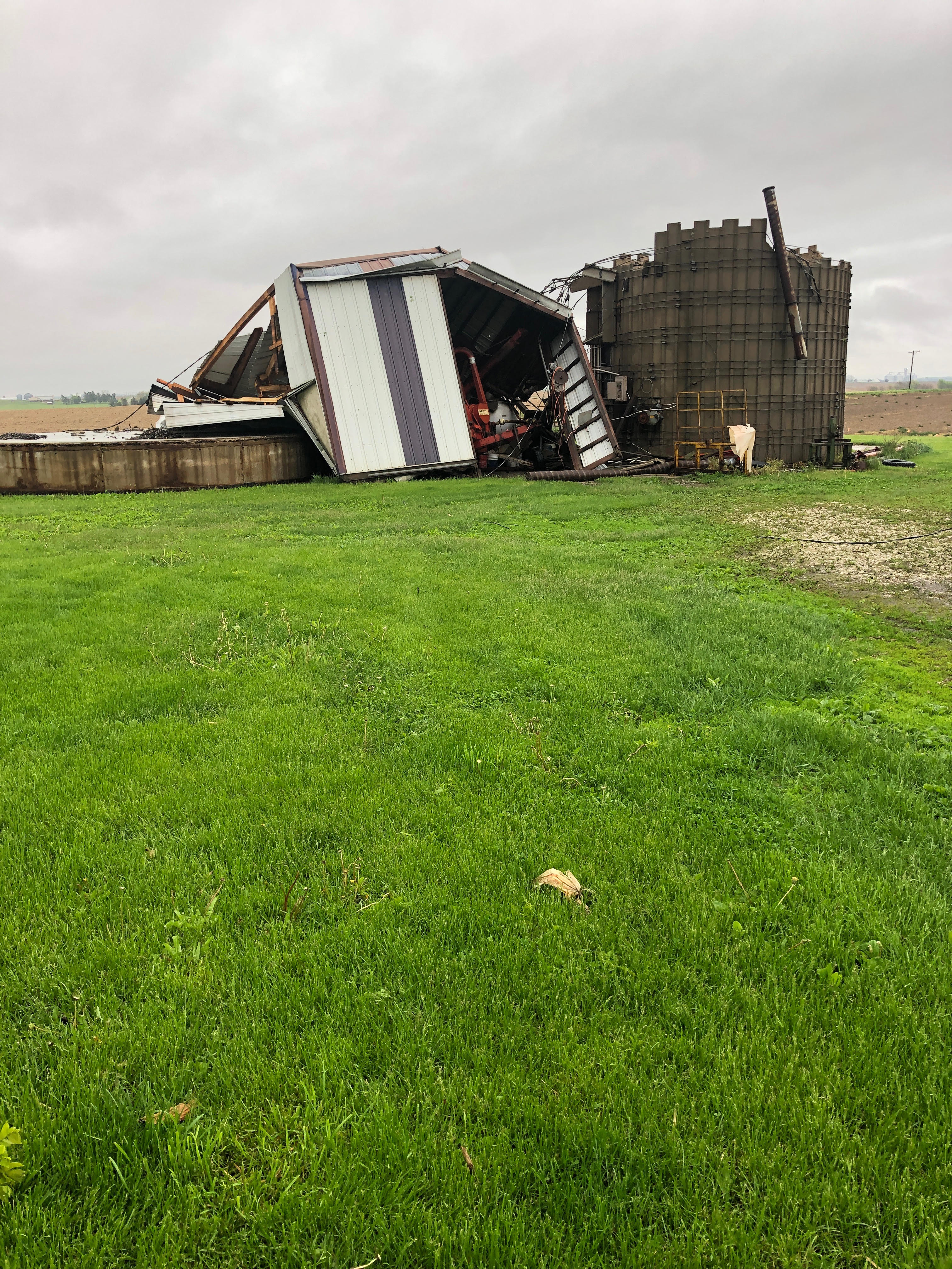
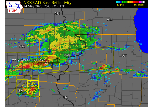
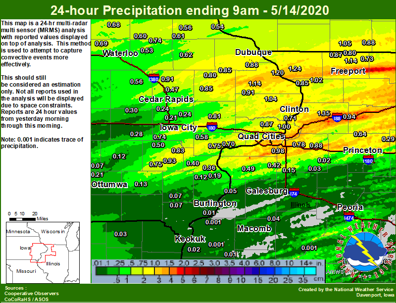
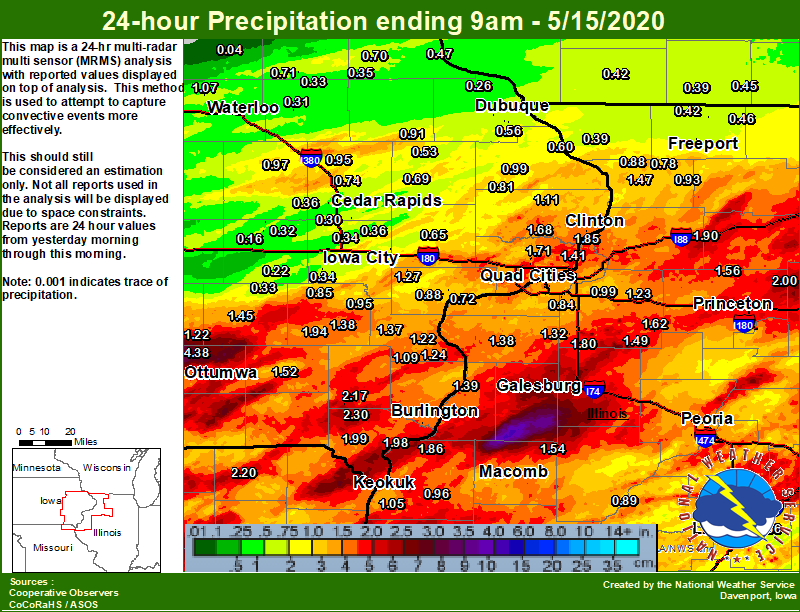
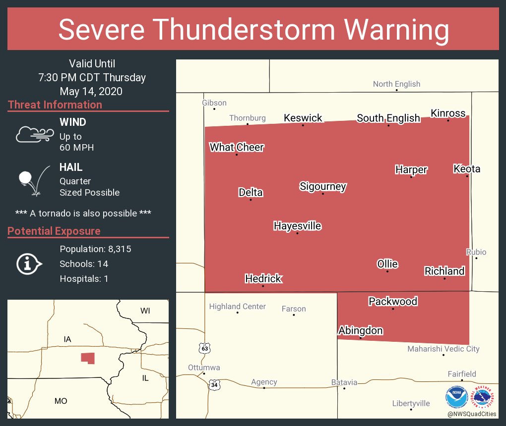
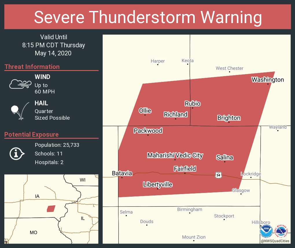
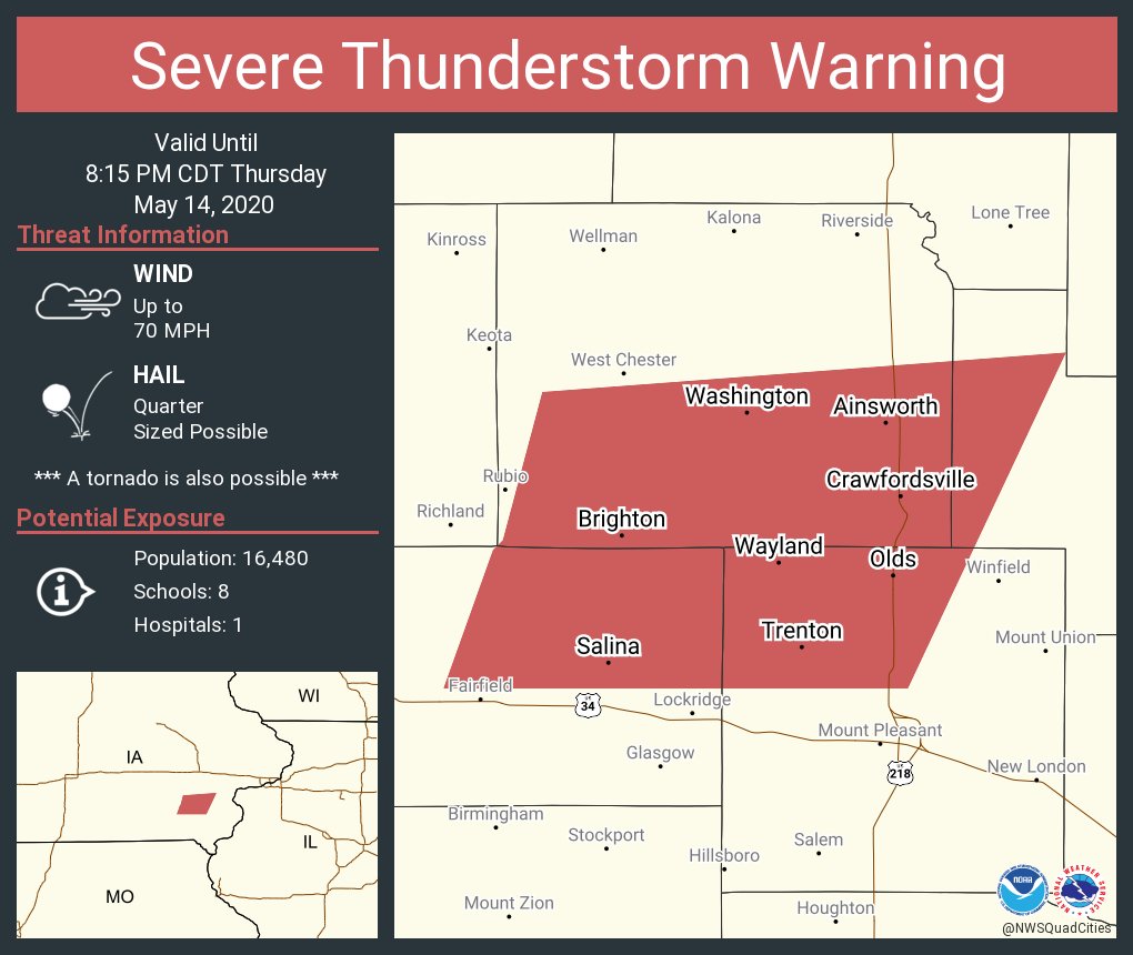
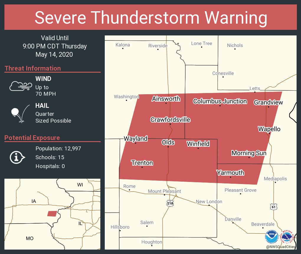
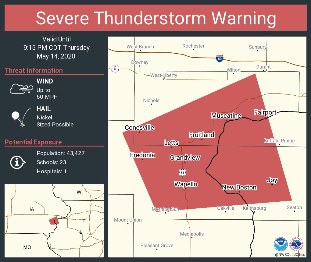
Showers and thunderstorms tracked across central Iowa into eastern Iowa, northeast Missouri, and northwest Illinois late Friday afternoon and into the overnight hours. These storms brought heavy rain, frequent lightning, damaging winds, and large hail to the region. The hardest hit areas were Keokuk county in Iowa towards Henry county in Iowa where 50-70 mph winds were found. A weak EF-1 tornado occurred near Atkinson, IL in Henry county in Illinois after 1015 pm and caused damage to trees and outbuildings at two farmsteads. Widespread rainfall amounts over 1 inch generally fell south of a line from Sigourney, IA to Maquoketa, to Freeport, IL. This rainfall combined with the previous days rain brought rain totals between 2-4 inches to the area. |
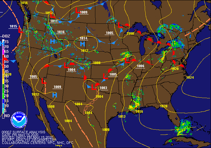 7 pm 5/14 Surface/Radar Analysis - Weather Prediction Center |
Tornadoes:
|
Tornado - 4.5 SSW Atkinson,IL
Track Map 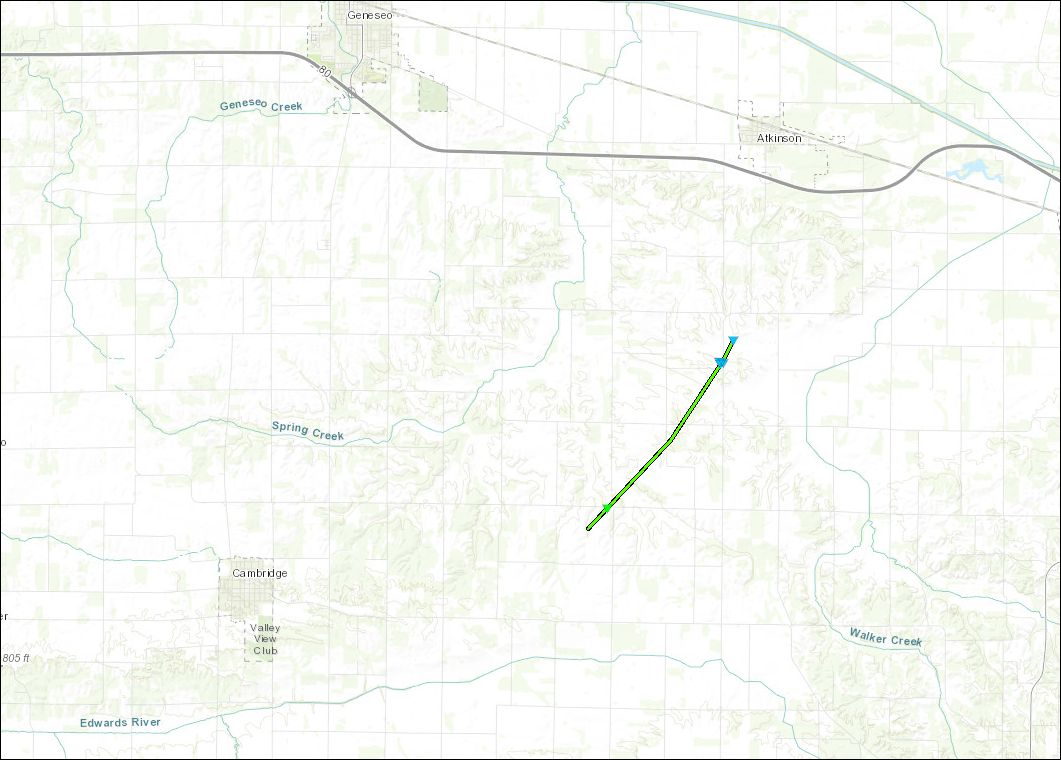 
|
||||||||||||||||
|
||||||||||||||||
The Enhanced Fujita (EF) Scale classifies tornadoes into the following categories:
| EF0 Weak 65-85 mph |
EF1 Moderate 86-110 mph |
EF2 Significant 111-135 mph |
EF3 Severe 136-165 mph |
EF4 Extreme 166-200 mph |
EF5 Catastrophic 200+ mph |
 |
|||||
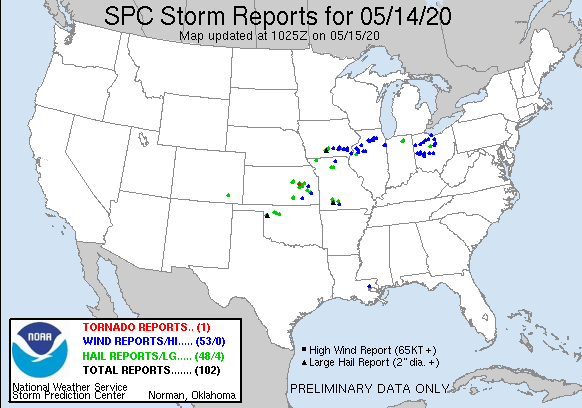
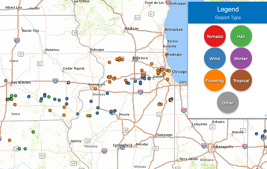
Storm Reports
| SPC Storm Reports | Interactive Storm Report Map |
 |
 |
PRELIMINARY LOCAL STORM REPORT...SUMMARY
NATIONAL WEATHER SERVICE QUAD CITIES IA IL
950 AM CDT FRI MAY 15 2020
..TIME... ...EVENT... ...CITY LOCATION... ...LAT.LON...
..DATE... ....MAG.... ..COUNTY LOCATION..ST.. ...SOURCE....
..REMARKS..
0701 PM TSTM WND DMG 3 SSW DELTA 41.28N 92.35W
05/14/2020 KEOKUK IA PUBLIC
TREES AND POWER LINES DOWN. MACHINE SHED
BLOWN INTO ROAD. TIME ESTIMATED BASED ON
RADAR.
0705 PM TSTM WND DMG 1 W DELTA 41.32N 92.35W
05/14/2020 KEOKUK IA CO-OP OBSERVER
LARGE BUILDINGS DAMAGED. POWER LINES AND
TREES DOWN. TIME ESTIMATED.
0730 PM TSTM WND DMG 1 E RICHLAND 41.19N 91.98W
05/14/2020 KEOKUK IA TRAINED SPOTTER
4 INCH DIAMETER BRANCH DOWN. SPOTTER
ESTIMATED WINDS FROM THE RFD TO BE NEAR 75
MPH. TIME ESTIMATED.
0800 PM LIGHTNING 4 E IOWA CITY 41.66N 91.46W
05/14/2020 JOHNSON IA TRAINED SPOTTER
LIGHTNING HIT A TRANSFORMER DOWNING POWER
LINES NEAR THE INTERSECTION OF COURT AND
TAFT. TIME ESTIMATED.
0805 PM TSTM WND DMG BRIGHTON 41.17N 91.82W
05/14/2020 WASHINGTON IA AMATEUR RADIO
5 INCH LIMB DOWN. SOME DITCHES ARE FILLING
UP AND SOME STREETS HAVE 2 INCHES OF WATER
ON THEM. TIME ESTIMATED.
0813 PM TSTM WND DMG 3 S SWEDESBURG 41.06N 91.54W
05/14/2020 HENRY IA PUBLIC
SEVERAL LARGE TREE LIMBS DOWN.
0818 PM TSTM WND GST CRAWFORDSVILLE 41.21N 91.53W
05/14/2020 M74 MPH WASHINGTON IA BROADCAST MEDIA
0942 PM TSTM WND GST BURLINGTON REGIONAL AIR 40.78N 91.12W
05/14/2020 M58 MPH DES MOINES IA ASOS
0945 PM TSTM WND DMG BURGESS 41.13N 90.63W
05/14/2020 MERCER IL UTILITY COMPANY
CORRECTS PREVIOUS TSTM WND DMG REPORT FROM
BURGESS. SEVERAL POWER OUTAGES NEAR AND
SOUTHEAST OF BURGESS.
1018 PM TSTM WND DMG 4 SSW ATKINSON 41.36N 90.03W
05/14/2020 HENRY IL EMERGENCY MNGR
ROOF BLOWN OFF A BARN, ALSO REPORTED TREE
DAMAGE NORTH OF THE LOCATION. POSSIBLE
TORNADO DAMAGE. TIME ESTIMATED FROM RADAR.
1052 PM HEAVY RAIN 1 NNW SELMA 40.88N 92.16W
05/14/2020 M3.50 INCH VAN BUREN IA TRAINED SPOTTER
24 HOUR RAIN AMOUNTS.
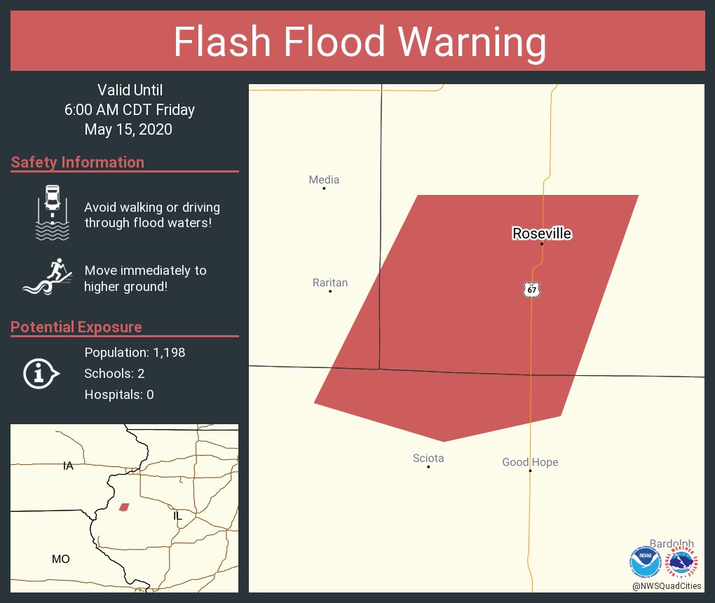
0149 AM FLASH FLOOD 4 W ROSEVILLE 40.73N 90.75W
05/15/2020 WARREN IL LAW ENFORCEMENT
STATE POLICE REPORTED THAT HIGHWAY 116 WEST
OF ROSEVILLE WAS FLOODED.
0400 AM HEAVY RAIN 4 S HILLSDALE 41.56N 90.19W
05/15/2020 M1.91 INCH ROCK ISLAND IL MESONET
MESONET STATION JOSI2 3.9 S HILLSDALE.
0430 AM HEAVY RAIN 2 WSW PRINCETON 41.37N 89.50W
05/15/2020 M1.88 INCH BUREAU IL MESONET
MESONET STATION PINI2 1.8 W PRINCETON.
0445 AM HEAVY RAIN 1 NW NIOTA 40.63N 91.30W
05/15/2020 M2.53 INCH HANCOCK IL MESONET
MESONET STATION FMDI4 1.0 NW NIOTA.
0500 AM HEAVY RAIN 1 E GALT 41.78N 89.75W
05/15/2020 M1.68 INCH WHITESIDE IL MESONET
MESONET STATION CMOI2 ROCK RIVER AT COMO.
0509 AM HEAVY RAIN 1 WSW MT HAMILL 40.74N 91.64W
05/15/2020 M2.80 INCH LEE IA TRAINED SPOTTER
CONSIDERABLE PONDING OF WATER IN FIELDS.
0515 AM HEAVY RAIN 3 W OAKLAND MILLS 40.93N 91.67W
05/15/2020 M1.85 INCH HENRY IA MESONET
MESONET STATION OKMI4 3.1 W OAKLAND MILLS.
0530 AM HEAVY RAIN AUGUSTA 40.75N 91.28W
05/15/2020 M1.70 INCH LEE IA MESONET
MESONET STATION AGSI4 AUGUSTA.
0530 AM HEAVY RAIN 1 WNW KEITHSBURG 41.11N 90.95W
05/15/2020 M1.53 INCH MERCER IL MESONET
MESONET STATION KHBI2 0.9 W KEITHSBURG.
0530 AM HEAVY RAIN 1 ENE BURLINGTON 40.82N 91.10W
05/15/2020 M1.56 INCH DES MOINES IA MESONET
MESONET STATION BRLI4 MISSISSIPPI RIVER.
0600 AM HEAVY RAIN 2 S PRAIRIE CITY 40.59N 90.46W
05/15/2020 M1.54 INCH MCDONOUGH IL CO-OP OBSERVER
CO-OP OBSERVER STATION PRCI2 2.0 S PRAIRIE
CITY.
0600 AM HEAVY RAIN 2 NNE COLUSA 40.59N 91.15W
05/15/2020 M1.86 INCH HANCOCK IL COCORAHS
COCORAHS STATION IL-HN-1 DALLAS CITY 3.0
SSE.
0600 AM HEAVY RAIN 5 NNE BRIGHTON 41.24N 91.77W
05/15/2020 M1.94 INCH WASHINGTON IA COCORAHS
COCORAHS STATION IA-WS-8 WASHINGTON 5.8 SW.
0600 AM HEAVY RAIN 1 WSW MEMPHIS 40.46N 92.18W
05/15/2020 M2.20 INCH SCOTLAND MO CO-OP OBSERVER
CO-OP OBSERVER STATION MMPM7 MEMPHIS.
0613 AM HEAVY RAIN 2 NE COLUSA 40.59N 91.15W
05/15/2020 M1.86 INCH HANCOCK IL TRAINED SPOTTER
CAMP CREEK NEAR IL HWY 9 STILL WITHIN ITS
BANKS.
0630 AM HEAVY RAIN 3 E SALEM 40.86N 91.56W
05/15/2020 M2.17 INCH HENRY IA COCORAHS
COCORAHS STATION IA-HY-5 SALEM 3.1 ESE.
0630 AM HEAVY RAIN KEOSAUQUA 40.73N 91.96W
05/15/2020 M1.92 INCH VAN BUREN IA MESONET
MESONET STATION KEQI4 KEOSAUQUA.
0630 AM HEAVY RAIN 1 SSW BALD BLUFF 41.00N 90.85W
05/15/2020 M1.52 INCH HENDERSON IL MESONET
MESONET STATION OQUI2 HENDERSON RIVER.
0646 AM HEAVY RAIN NAUVOO 40.55N 91.39W
05/15/2020 M3.00 INCH HANCOCK IL TRAINED SPOTTER
OVERNIGHT TOTAL.
0656 AM HEAVY RAIN 1 E WHITESIDE COUNTY AI 41.75N 89.67W
05/15/2020 M2.22 INCH WHITESIDE IL AWOS
AWOS STATION KSQI STERLING/ROCK FALLS ARPT.
0658 AM HEAVY RAIN DAVENPORT MUNICIPALITY 41.62N 90.58W
05/15/2020 M1.70 INCH SCOTT IA ASOS
ASOS STATION KDVN DAVENPORT ARPT.
0700 AM HEAVY RAIN 3 E STERLING 41.80N 89.64W
05/15/2020 M1.90 INCH WHITESIDE IL CO-OP OBSERVER
CO-OP OBSERVER STATION RCFI2 ROCK FALLS 3
NE.
0700 AM HEAVY RAIN 1 SW NEW LONDON 40.91N 91.43W
05/15/2020 M1.81 INCH HENRY IA COCORAHS
COCORAHS STATION IA-HY-1 NEW LONDON 1.5 SW.
0700 AM HEAVY RAIN 1 E KEWANEE 41.24N 89.90W
05/15/2020 M1.62 INCH HENRY IL CO-OP OBSERVER
CO-OP OBSERVER STATION KEWI2 KEWANEE 1 E.
0700 AM HEAVY RAIN PRINCETON 41.38N 89.46W
05/15/2020 M1.66 INCH BUREAU IL CO-OP OBSERVER
CO-OP OBSERVER STATION PTNI2 PRINCETON.
0700 AM HEAVY RAIN PARK VIEW 41.69N 90.54W
05/15/2020 M1.71 INCH SCOTT IA COCORAHS
COCORAHS STATION IA-ST-3 PARK VIEW 0.2 WSW.
0700 AM HEAVY RAIN WOODHULL 41.18N 90.32W
05/15/2020 M1.80 INCH HENRY IL COCORAHS
COCORAHS STATION IL-HY-11 WOODHULL 0.3 ESE.
0700 AM HEAVY RAIN 1 NW ELDRIDGE 41.65N 90.59W
05/15/2020 M1.80 INCH SCOTT IA COCORAHS
COCORAHS STATION IA-ST-21 ELDRIDGE 0.6 S.
0700 AM HEAVY RAIN CAMANCHE 41.80N 90.28W
05/15/2020 M1.85 INCH CLINTON IA COCORAHS
COCORAHS STATION IA-CN-5 CAMANCHE 1.2 W.
0700 AM HEAVY RAIN DONNELLSON 40.65N 91.56W
05/15/2020 M1.99 INCH LEE IA CO-OP OBSERVER
CO-OP OBSERVER STATION DNNI4 DONNELLSON.
0700 AM HEAVY RAIN 2 WSW SPRING GROVE 40.73N 91.19W
05/15/2020 M2.14 INCH DES MOINES IA COCORAHS
COCORAHS STATION IA-DM-7 BURLINGTON 6.5 SSW.
0700 AM HEAVY RAIN 3 NW OHIO 41.58N 89.50W
05/15/2020 M1.56 INCH BUREAU IL COCORAHS
COCORAHS STATION IL-BU-11 WALNUT 5.3 ENE.
0700 AM HEAVY RAIN PROPHETSTOWN 41.67N 89.94W
05/15/2020 M2.14 INCH WHITESIDE IL COCORAHS
COCORAHS STATION IL-WD-18 PROPHETSTOWN 0.2
SW.
0700 AM HEAVY RAIN 1 S SALEM 40.84N 91.62W
05/15/2020 M2.44 INCH HENRY IA CO-OP OBSERVER
CO-OP OBSERVER STATION SLHI4 SALEM 1 S.
0700 AM HEAVY RAIN BRIGHTON 41.17N 91.83W
05/15/2020 M2.26 INCH WASHINGTON IA CO-OP OBSERVER
CO-OP OBSERVER STATION BTNI4 BRIGHTON.
0700 AM HEAVY RAIN DAVENPORT MUNICIPALITY 41.61N 90.58W
05/15/2020 M1.94 INCH SCOTT IA CO-OP OBSERVER
CO-OP OBSERVER STATION DVNI4 DAVENPORT 6 N.
0700 AM HEAVY RAIN 1 NE FORT MADISON 40.63N 91.34W
05/15/2020 M1.98 INCH LEE IA COCORAHS
COCORAHS STATION IA-LE-8 FORT MADISON 0.9
NE.
0715 AM HEAVY RAIN 4 S DEWITT 41.77N 90.53W
05/15/2020 M2.24 INCH SCOTT IA MESONET
MESONET STATION DEWI4 3.9 S DEWITT.
0720 AM HEAVY RAIN 2 NW PILOT GROVE 40.78N 91.56W
05/15/2020 M2.30 INCH LEE IA COCORAHS
COCORAHS STATION IA-LE-11 WEST POINT 7.5 NW.
0730 AM HEAVY RAIN 1 SE BURLINGTON 40.79N 91.11W
05/15/2020 M1.63 INCH DES MOINES IA COCORAHS
COCORAHS STATION IA-DM-13 BURLINGTON 1.5 SE.
0731 AM HEAVY RAIN 2 SW DAVENPORT MUNICIPA 41.59N 90.61W
05/15/2020 M1.77 INCH SCOTT IA MESONET
MESONET STATION DW3396 DAVENPORT.
0734 AM HEAVY RAIN 1 SW STRONGHURST 40.74N 90.91W
05/15/2020 M1.84 INCH HENDERSON IL MESONET
MESONET STATION CW6338 STRONGHURST.
0738 AM HEAVY RAIN 1 S BURLINGTON REGIONAL 40.77N 91.13W
05/15/2020 M1.65 INCH DES MOINES IA ASOS
ASOS STATION KBRL BURLINGTON ARPT.
0739 AM HEAVY RAIN CAMBRIDGE 41.30N 90.20W
05/15/2020 M1.50 INCH HENRY IL TRAINED SPOTTER
OVERNIGHT TOTAL.
0740 AM HEAVY RAIN 1 NW DAVENPORT 41.56N 90.62W
05/15/2020 M1.68 INCH SCOTT IA TRAINED SPOTTER
OVERNIGHT TOTAL.
0740 AM HEAVY RAIN BONAPARTE 40.70N 91.80W
05/15/2020 M2.75 INCH VAN BUREN IA TRAINED SPOTTER
OVERNIGHT TOTAL.
0742 AM HEAVY RAIN 1 NE FORT MADISON 40.64N 91.33W
05/15/2020 M2.60 INCH LEE IA TRAINED SPOTTER
OVERNIGHT TOTAL.
0742 AM HEAVY RAIN 1 ESE MUSCATINE 41.41N 91.06W
05/15/2020 M1.75 INCH MUSCATINE IA TRAINED SPOTTER
OVERNIGHT TOTAL.
0800 AM HEAVY RAIN 3 SSW ELEANOR 40.94N 90.72W
05/15/2020 M2.07 INCH WARREN IL CO-OP OBSERVER
CO-OP OBSERVER STATION MMTI2 MONMOUTH 4 NW.
0800 AM HEAVY RAIN 1 NW ELDRIDGE 41.64N 90.59W
05/15/2020 M1.75 INCH SCOTT IA COCORAHS
COCORAHS STATION IA-ST-30 ELDRIDGE 0.7 SSW.
0800 AM HEAVY RAIN 1 SSE DEWITT 41.81N 90.54W
05/15/2020 M1.68 INCH CLINTON IA CO-OP OBSERVER
CO-OP OBSERVER STATION DWTI4 DE WITT.
0800 AM HEAVY RAIN 1 NNE FAIRFIELD 41.02N 91.96W
05/15/2020 M1.52 INCH JEFFERSON IA CO-OP OBSERVER
CO-OP OBSERVER STATION FRFI4 FAIRFIELD.
0839 AM HEAVY RAIN 2 ESE KEOSAUQUA 40.72N 91.92W
05/15/2020 M1.70 INCH VAN BUREN IA TRAINED SPOTTER
OVERNIGHT TOTAL.
0900 AM HEAVY RAIN LA HARPE 40.58N 90.97W
05/15/2020 M1.80 INCH HANCOCK IL CO-OP OBSERVER
CO-OP OBSERVER STATION LAHI2 LA HARPE.
0900 AM HEAVY RAIN UNIONVILLE 41.81N 89.98W
05/15/2020 M1.85 INCH WHITESIDE IL TRAINED SPOTTER
24 HOUR TOTAL. 3.35 INCHES REPORTED OVER THE
PAST TWO DAYS.
0905 AM HEAVY RAIN 3 WNW MOUNT STERLING 40.63N 92.00W
05/15/2020 M2.60 INCH VAN BUREN IA TRAINED SPOTTER
RAINFALL SINCE 9 PM CDT LAST NIGHT.
0932 AM HEAVY RAIN 2 SW DAVENPORT MUNICIPA 41.59N 90.61W
05/15/2020 M1.77 INCH SCOTT IA MESONET
MESONET STATION DW3396 DAVENPORT.
Rain Reports
| Jump to 48-hr Rainfall | |||
| 5/14 LOCAL RAINFALL | 5/15 LOCAL RAINFALL | ||
 |
 |
||
24 hour precipitation reports (in Inches),
for eastern Iowa, northwest and west central Illinois,
and northeast Missouri. Reported between Midnight and 9 AM,
Thursday May 14, 2020.

....IOWA....
Bellevue LD12                    1.20
Riverdale 0.5 N                  1.19
Fulton                           1.14
Bettendorf 1.6 W                 1.06
Charlotte 1.9 WNW                1.04
Davenport Arpt                   1.00
Dubuque #3 7 SW                  1.00
Le Claire 1.8 NNE                1.00
Peosta 2.9 E                     0.99
Le Claire LD14                   0.96
Iowa City Arpt                   0.93
Washington                       0.93
Maquoketa 4 W                    0.91
Central City 6.7 W               0.91
Dubuque Arpt                     0.88
Park View 0.2 WSW                0.87
Davenport 0.9 WNW                0.86
Eldridge 0.6 S                   0.85
Cascade                          0.85
Anamosa 1.9 SE                   0.85
Ainsworth 7.4 N                  0.83
Eldridge 0.7 SSW                 0.82
Tipton 0.7 N                     0.81
West Branch 2.0 NNW              0.81
Iowa City                        0.80
Monticello 1 E                   0.80
Center Point 0.6 NNW             0.79
Anamosa 3 SSW                    0.79
Muscatine 2.1 N                  0.75
Washington 5.8 SW                0.75
Kalona 7.3 NNW                   0.74
Stanley                          0.74
Camanche 1.2 W                   0.71
Muscatine 2N                     0.70
Dubuque LD11                     0.69
Waterloo ASOS 5 NW               0.69
Tripoli 0 N                      0.68
Manchester                       0.62
Strawberry Point                 0.61
Oelwein AWOS                     0.60
West Liberty 0.7 NNW             0.58
Elkader 6SSW                     0.56
Vinton                           0.56
Fayette 1 NW                     0.55
Guttenberg Dam 10                0.54
Independence 1.2 N               0.53
Oelwein 1E                       0.52
Independence 0.9 WNW             0.51
Wellman 4.0 E                    0.50
Cedar Rapids 2.5 WSW             0.48
Marion 1.7 NNW                   0.47
Hampton 1 N                      0.47
Ely 0.5 SE                       0.44
Cedar Rapids 2.7 NE              0.41
Columbus Jct 2 SSW               0.40
Wapello 0.2 S                    0.36
Fairfax 4.0 NW                   0.35
Boone 1 SSW                      0.35
Marshalltown 1 NW                0.33
Marengo 3.6 N                    0.30
Ames US 30 2 SSE                 0.29
Parnell 0.1 SSW                  0.28
Newton 1 NE                      0.27
Marshalltown ASOS 4 N            0.26
Toledo 3 N                       0.26
Solon 0.3 ESE                    0.24
Cedar Rapids Arpt 5 SW           0.24
North Liberty 0.7 SSW            0.21
Ottumwa ASOS 6 NNW               0.21
Wapello 5.4 SE                   0.19
NWS Johnston* 5 NNW              0.19
Mason City 1 NNE                 0.18
Oskaloosa 1 NNW                  0.18
Beaconsfield 1 NNE               0.18
Perry 0 W                        0.13
Fairfield                        0.13
Mason City ASOS 6 W              0.13
Morning Sun 1.7 E                0.12
Sigourney                        0.12
Centerville 0 NE                 0.10
West Point 7.5 NW                0.07
Salem 3.1 ESE                    0.07
Oskaloosa AWOS 9 ESE             0.07
Waukon 3N                        0.07
Rathbun Reservoir 2 N            0.05
Pella 4 N                        0.05
New London 1.5 SW                0.05
Burlington 2.1 S                 0.05
Salem 1S                         0.04
Burlington Arpt 2 SW             0.01
Burlington 6.5 SSW               0.01
Pella AWOS 2 WSW                 0.01
....ILLINOIS....
Freeport 2.0 NW                  2.00
Freeport                         1.96
Freeport 1.7 NW                  1.92
Ridott 0.1 NE                    1.74
Freeport 1.7 ESE                 1.74
Moline 0.7 NNE                   1.36
Morrison 3.2 E                   1.35
Elizabeth                        1.24
Moline 1.0 WNW                   1.18
Dakota 4.8 NW                    1.14
Quad City Arpt                   1.08
Mount Carroll 6.8 NNW            1.02
Coal Valley 1.9 SE               0.98
Coal Valley 2.6 E                0.97
Rock Falls                       0.94
Mundelein                        0.92
Roscoe 2SE                       0.92
Atkinson 2.6 NNE                 0.88
Winslow 4.3 ESE                  0.87
Savanna 4.6 N                    0.85
Orangeville 2.8 NW               0.80
Geneseo 2.0 NW                   0.78
Davis 0.5 N                      0.73
Rockford ASOS                    0.65
Steward                          0.65
Walnut 5.3 ENE                   0.64
Alpha 2.3 N                      0.53
Alpha 0.7 N                      0.52
Aledo                            0.49
New Windsor 2.0 N                0.42
Mendota 2 SE                     0.29
New Boston LD17                  0.16
Woodhull 0.3 ESE                 0.15
St Anne                          0.13
Colchester 3.5 NE                0.07
Oquawka 0.5 N                    0.05
|
24 hour precipitation reports (in Inches),
for eastern Iowa, northwest and west central Illinois,
and northeast Missouri. Reported between Midnight and 9 AM,
Friday May 15, 2020.

....IOWA....
Ottumwa ASOS                     4.38
Salem 1S                         2.44
West Point 7.5 NW                2.30
Brighton                         2.26
Salem 3.1 ESE                    2.17
Burlington 6.5 SSW               2.14
Donnellson                       1.99
Fort Madison 0.9 NE              1.98
Washington 5.8 SW                1.94
Camanche 1.2 W                   1.85
Burlington 0.8 SSE               1.83
Eldridge 0.6 S                   1.80
Eldridge 0.7 SSW                 1.75
Park View 0.2 WSW                1.71
Davenport Arpt                   1.70
De Witt                          1.68
Burlington Arpt 2 SW             1.65
Burlington 1.5 SE                1.63
Rathbun Reservoir 2 N            1.52
Oskaloosa 1 NNW                  1.52
Fairfield                        1.52
Davenport 0.9 WNW                1.45
Sigourney                        1.45
Le Claire 1.8 NNE                1.41
Le Claire LD14                   1.40
Riverdale 0.5 N                  1.39
Washington                       1.38
Columbus Jct 2 SSW               1.37
Davenport 0.9 SSW                1.29
West Liberty 0.7 NNW             1.27
Wapello 5.4 SE                   1.24
Bettendorf 2.2 SE                1.23
Wapello 0.2 S                    1.22
Oskaloosa AWOS 9 ESE             1.22
Pella 4 N                        1.21
Center Point 0.6 NNW             1.14
Charlotte 1.9 WNW                1.11
Morning Sun 1.7 E                1.09
Waterloo ASOS 5 NW               1.07
Fulton                           0.99
Vinton                           0.97
Central City 6.7 W               0.95
Ainsworth 7.4 N                  0.95
Centerville 0 NE                 0.93
Hopkinton 0.2 NE                 0.91
Muscatine 2N                     0.91
Muscatine 2.1 N                  0.90
Muscatine 2.1 NNW                0.88
Wellman 4.0 E                    0.85
Anamosa 3 SSW                    0.83
Maquoketa 4 W                    0.81
Oelwein 1E                       0.77
Marion 1.7 NNW                   0.74
Oelwein AWOS                     0.71
Elkader 6SSW                     0.70
Anamosa 1.9 SE                   0.69
Tipton 0.7 N                     0.65
Bellevue LD12                    0.60
Marshalltown ASOS 4 N            0.60
West Branch 2.0 NNW              0.57
Dubuque Arpt                     0.56
Marshalltown 1 NW                0.53
Monticello 1 E                   0.53
Iowa City Arpt                   0.48
Guttenberg Dam 10                0.47
Dubuque #3 7 SW                  0.47
Ely 0.5 SE                       0.46
Peosta 2.9 E                     0.42
Newton 1 NE                      0.41
Independence 0.9 WNW             0.38
Fairfax 4.0 NW                   0.36
Solon 0.3 ESE                    0.36
Dubuque LD11                     0.35
Strawberry Point                 0.35
Kalona 7.3 NNW                   0.34
North Liberty 0.7 SSW            0.34
North English                    0.33
Stanley                          0.33
Amana 4.7 W                      0.32
Independence 1.2 N               0.31
Cedar Rapids Arpt 5 SW           0.30
Asbury 0.4 SW                    0.28
Rickardsville 0.2 W              0.26
Beaconsfield 1 NNE               0.26
Cedar Rapids 2.5 WSW             0.25
Marengo                          0.25
Marengo 3.6 N                    0.23
Parnell 0.1 SSW                  0.22
Toledo 3 N                       0.21
NWS Johnston* 5 NNW              0.20
Fayette 1 NW                     0.20
Marengo 2.6 SSW                  0.16
Boone 1 SSW                      0.16
Ames US 30 2 SSE                 0.07
Perry 0 W                        0.06
Tripoli 0 N                      0.04
Waukon 3N                        0.01
Hampton 1 N                      0.00
Mason City ASOS 6 W              0.00
Pella AWOS 2 WSW                 0.00
....ILLINOIS....
Steward                          2.78
Galesburg                        2.50
St Anne                          2.49
Rochelle AWOS                    2.37
Galesburg Arpt 3 SW              2.12
Monmouth 4NW                     2.07
Mendota 2 SE                     2.00
Romeoville                       1.95
Mundelein                        1.94
Rock Falls                       1.90
Dallas City 3.0 SSE              1.86
Woodhull 0.3 ESE                 1.80
Quincy ASOS                      1.67
Princeton                        1.66
Princeton 1.1 SE                 1.66
Kewanee 1 E                      1.62
Paw Paw 1 E                      1.61
Walnut 5.3 ENE                   1.56
Prairie City 2S                  1.54
Galva 2.7 NE                     1.49
Mount Carroll                    1.47
Bloomington Airport              1.47
Alpha 0.7 N                      1.42
Alpha 2.3 N                      1.40
Oquawka 0.5 N                    1.39
Aledo                            1.38
New Boston LD17                  1.36
Ottawa 4 SW                      1.35
Gladstone LD18                   1.35
New Windsor 2.0 N                1.32
Moline 1.0 WNW                   1.28
Atkinson 2.6 NNE                 1.23
Jacksonville 2E                  1.13
Moline 0.7 NNE                   1.07
Warsaw 5.8 SE                    1.05
Rockford ASOS                    1.03
Jacksonville AWOS                1.01
Macomb                           1.00
Geneseo 2.0 NW                   0.99
Coal Valley 2.6 E                0.98
Quad City Arpt                   0.96
Bentley                          0.96
Peoria ASOS                      0.96
Colchester 3.5 NE                0.94
Lanark 6.0 E                     0.93
Streator 3 SE                    0.90
Havana                           0.89
Mount Carroll 6.8 NNW            0.88
Joliet                           0.84
Coal Valley 1.9 SE               0.84
Roscoe 2SE                       0.83
Lanark 5.3 N                     0.78
Ill. City LD16 3 WNW             0.72
Lincoln NWS                      0.66
Decatur Airport                  0.62
Freeport 2.9 WSW                 0.52
Freeport                         0.51
Freeport 2.0 NW                  0.50
Freeport 1.7 NW                  0.49
Ridott 0.1 NE                    0.47
Windsor                          0.46
Davis 0.5 N                      0.46
Winslow 4.3 ESE                  0.42
Elizabeth                        0.39
Dakota 4.8 NW                    0.37
Ogden                            0.37
Tuscola                          0.25
....MISSOURI....
Kirksville ASOS                  3.30
Chillicothe 2 NW                 2.62
Memphis                          2.20
Columbia                         1.07
|
||
| 48-hr LOCAL RAINFALL | 48-hr REGIONAL RAINFALL | ||
 |
 |
||
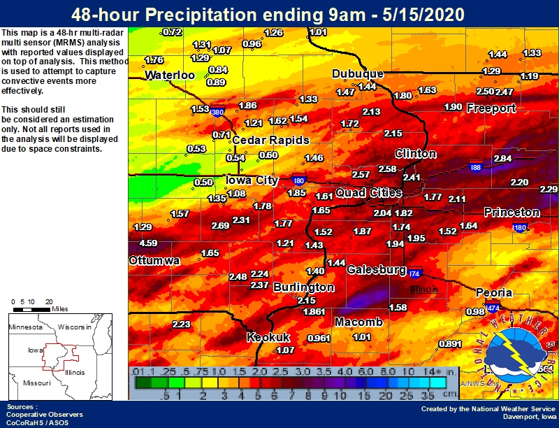
Public Information Statement
National Weather Service Quad Cities IA IL
958 AM CDT Fri May 15 2020

...Highest 48-hr Rainfall Reports...

Observations are collected from a variety of sources with varying
equipment and exposures. We thank all volunteer weather observers
for their dedication. Not all data listed are considered official.

Location                     Amount    Time/Date       Provider
Prophetstown 0.2 SW          4.17 in   0700 AM 05/15   COCORAHS
Le Claire                    3.90 in   0800 AM 05/15   SPOTTER
3.9 S Dewitt                 3.24 in   0930 AM 05/15   HADS
Sterling/Rock Falls Arpt     3.09 in   0939 AM 05/15   AWOS
1 S Cordova                  3.00 IN   0800 AM 05/15   SPOTTER
Rock River at Como           2.84 in   0800 AM 05/15   HADS
Rock Falls 3 NE              2.84 in   0700 AM 05/15   COOP
Davenport 6 N                2.83 in   0700 AM 05/15   COOP
De Witt                      2.81 in   0800 AM 05/15   COOP
Morrison 3.2 E               2.80 in   0700 AM 05/15   COCORAHS
Washington 5.8 SW            2.69 in   0600 AM 05/15   COCORAHS
Eldridge 0.6 S               2.65 in   0700 AM 05/15   COCORAHS
Morrison                     2.64 in   0944 AM 05/15   AWS
Park View 0.2 WSW            2.58 in   0700 AM 05/15   COCORAHS
Riverdale 0.5 N              2.58 in   0700 AM 05/15   COCORAHS
Eldridge 0.7 SSW             2.57 in   0800 AM 05/15   COCORAHS
Camanche 1.2 W               2.56 in   0700 AM 05/15   COCORAHS
Davenport                    2.54 in   0932 AM 05/15   CWOP
Davenport 0.9 SSW            2.50 in   0700 AM 05/15   COCORAHS
Freeport 2.0 NW              2.50 in   0700 AM 05/15   COCORAHS
Salem 1 S                    2.48 in   0700 AM 05/15   COOP
Moline 1.0 WNW               2.46 in   0700 AM 05/15   COCORAHS
Moline 0.7 NNE               2.43 in   0700 AM 05/15   COCORAHS
Le Claire 1.8 NNE            2.41 in   0800 AM 05/15   COCORAHS
Bettendorf 2.2 SE            2.41 in   0700 AM 05/15   COCORAHS
Freeport 1.7 NW              2.41 in   0659 AM 05/15   COCORAHS
West Point 7.5 NW            2.37 in   0720 AM 05/15   COCORAHS
Freeport 1.7 ESE             2.31 in   0700 AM 05/15   COCORAHS
Washington 2 SSW             2.31 in   0700 AM 05/15   COOP
Sterling                     2.28 in   0940 AM 05/15   CWOP
Memphis                      2.23 in   0600 AM 05/15   COOP
Ridott 0.1 NE                2.21 in   0707 AM 05/15   COCORAHS
Walnut 5.3 ENE               2.20 in   0700 AM 05/15   COCORAHS
2.9 N Rock Island            2.20 in   0830 AM 05/15   HADS
Charlotte 1.9 WNW            2.15 in   0700 AM 05/15   COCORAHS
Burlington 6.5 SSW           2.15 in   0700 AM 05/15   COCORAHS
Washington                   2.12 in   0945 AM 05/15   AWS
Atkinson 2.6 NNE             2.11 in   0800 AM 05/15   COCORAHS
Mississippi River            2.09 in   0830 AM 05/15   HADS
2 SSE Osborn                 2.05 in   0941 AM 05/15   CWOP
Quad City Intl Arpt          2.04 in   0859 AM 05/15   ASOS
Morrison                     1.96 in   0941 AM 05/15   CWOP
Woodhull 0.3 ESE             1.95 in   0700 AM 05/15   COCORAHS
Coal Valley 2.6 E            1.95 in   0700 AM 05/15   COCORAHS
Alpha 0.7 N                  1.94 in   0700 AM 05/15   COCORAHS
Center Point 0.6 NNW         1.93 in   0600 AM 05/15   COCORAHS
Alpha 2.3 N                  1.93 in   0642 AM 05/15   COCORAHS
Davenport Arpt               1.93 in   0902 AM 05/15   ASOS
3.1 W Oakland Mills          1.92 in   0930 AM 05/15   HADS
Mount Carroll 6.8 NNW        1.90 in   0700 AM 05/15   COCORAHS
0.9 W Keithsburg             1.88 in   0900 AM 05/15   HADS
Aledo                        1.87 in   0700 AM 05/15   COOP
2.1 NE Keithsburg            1.87 in   0745 AM 05/15   HADS
New London 1.5 SW            1.86 in   0700 AM 05/15   COCORAHS
Central City 6.7 W           1.86 in   0700 AM 05/15   COCORAHS
Dallas City 3.0 SSE          1.86 in   0600 AM 05/15   COCORAHS
Mount Carroll                1.85 in   0931 AM 05/15   CWOP
West Liberty 0.7 NNW         1.85 in   0700 AM 05/15   COCORAHS
West Branch                  1.84 in   0830 AM 05/15   HADS
Eldridge                     1.83 in   0932 AM 05/15   CWOP
Mediapolis 0.2 WNW           1.83 in   0800 AM 05/15   COCORAHS
Clinton Arpt                 1.83 in   0917 AM 05/15   AWOS
Coal Valley 1.9 SE           1.82 in   0700 AM 05/15   COCORAHS
Freeport 2.9 WSW             1.81 in   0730 AM 05/15   COCORAHS
La Harpe                     1.80 in   0900 AM 05/15   COOP
Ainsworth 7.4 N              1.78 in   0700 AM 05/15   COCORAHS
Geneseo 2.0 NW               1.77 in   0500 AM 05/15   COCORAHS
Grandview                    1.76 in   0932 AM 05/15   CWOP
Muscatine                    1.75 in   0940 AM 05/15   CWOP
0.7 NE Palo                  1.75 in   0900 AM 05/15   HADS
New Windsor 2.0 N            1.74 in   0700 AM 05/15   COCORAHS
Augusta                      1.72 in   0915 AM 05/15   HADS
0.5 SW Fredonia              1.72 in   0730 AM 05/15   HADS
Burlington Arpt              1.72 in   0914 AM 05/15   ASOS
Maquoketa                    1.72 in   0700 AM 05/15   COOP
Dam 13                       1.71 in   0810 AM 05/15   HADS
Burlington 2.1 S             1.70 in   0700 AM 05/15   COCORAHS
Iowa City                    1.68 in   0940 AM 05/15   CWOP
West Chester 0.1 SW          1.68 in   0700 AM 05/15   COCORAHS
Princeton 1.1 SE             1.66 in   0700 AM 05/15   COCORAHS
Princeton                    1.66 in   0700 AM 05/15   COOP
Fairfield                    1.65 in   0800 AM 05/15   COOP
Muscatine 2.1 N              1.65 in   0700 AM 05/15   COCORAHS
Mississippi River            1.64 in   0900 AM 05/15   HADS
Kewanee 1 E                  1.64 in   0700 AM 05/15   COOP
Muscatine                    1.64 in   0700 AM 05/15   COOP
Mt. Carroll                  1.63 in   0943 AM 05/15   CWOP
Elizabeth                    1.63 in   0630 AM 05/15   COOP
Anamosa 3 SSW                1.62 in   0600 AM 05/15   COOP
2 N Muscatine                1.61 in   0700 AM 05/15   COOP
1.1 W Oakville               1.61 in   0845 AM 05/15   HADS
Wapello 0.2 S                1.58 in   0700 AM 05/15   COCORAHS
Henderson River              1.58 in   0830 AM 05/15   HADS
2.0 S Prairie City           1.58 in   0600 AM 05/15   COOP
Cedar River Tnc Swamp        1.58 in   0846 AM 05/15   RAWS
Sigourney                    1.57 in   0800 AM 05/15   COOP
Vinton                       1.57 in   0845 AM 05/15   HADS
Princeton                    1.56 in   0931 AM 05/15   CWOP
Anamosa 1.9 SE               1.54 in   0454 AM 05/15   COCORAHS
Vinton                       1.53 in   0700 AM 05/15   COOP
Bellevue                     1.52 in   0830 AM 05/15   HADS
Galva 2.7 NE                 1.52 in   0600 AM 05/15   COCORAHS
Dakota 4.8 NW                1.51 in   0700 AM 05/15   COCORAHS
Environment
 |
 |
 |
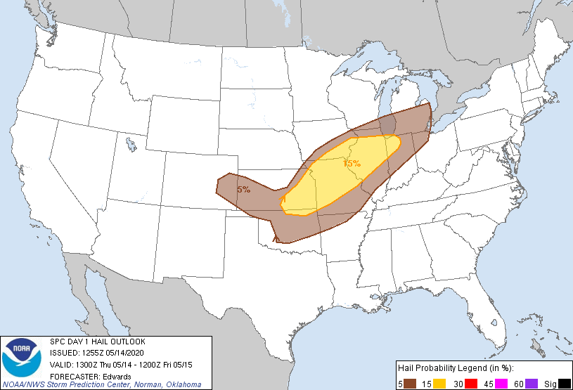 |
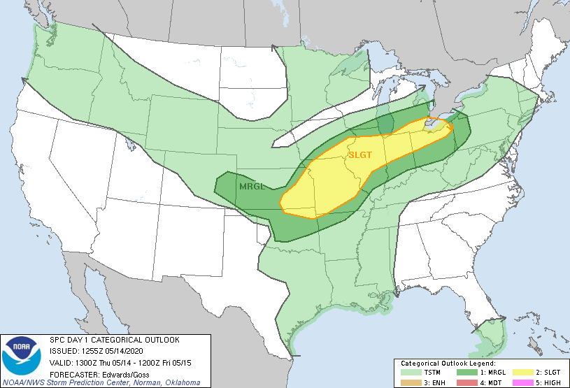
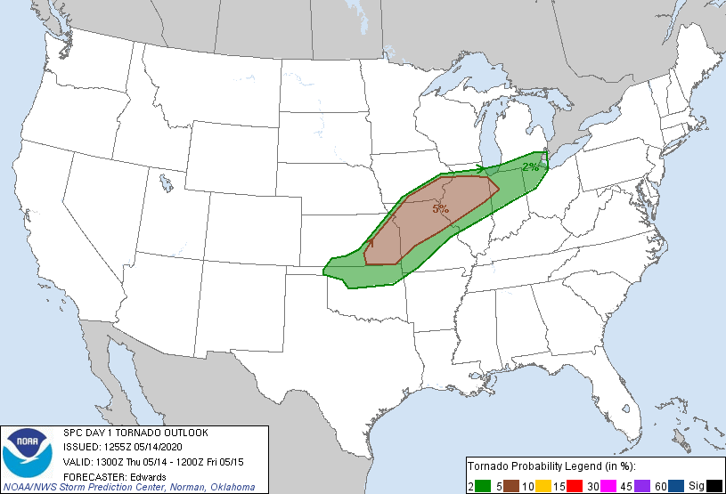
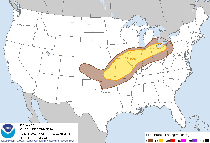
| Figure 1: Outlook | Figure 2: Tornado Outlook | Figure 3: Wind Outlook | Figure 4: Hail Outlook |
 |
 |
 |
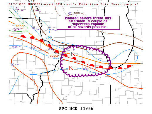 |
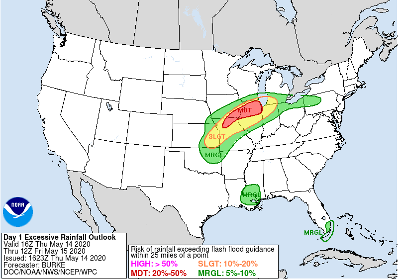
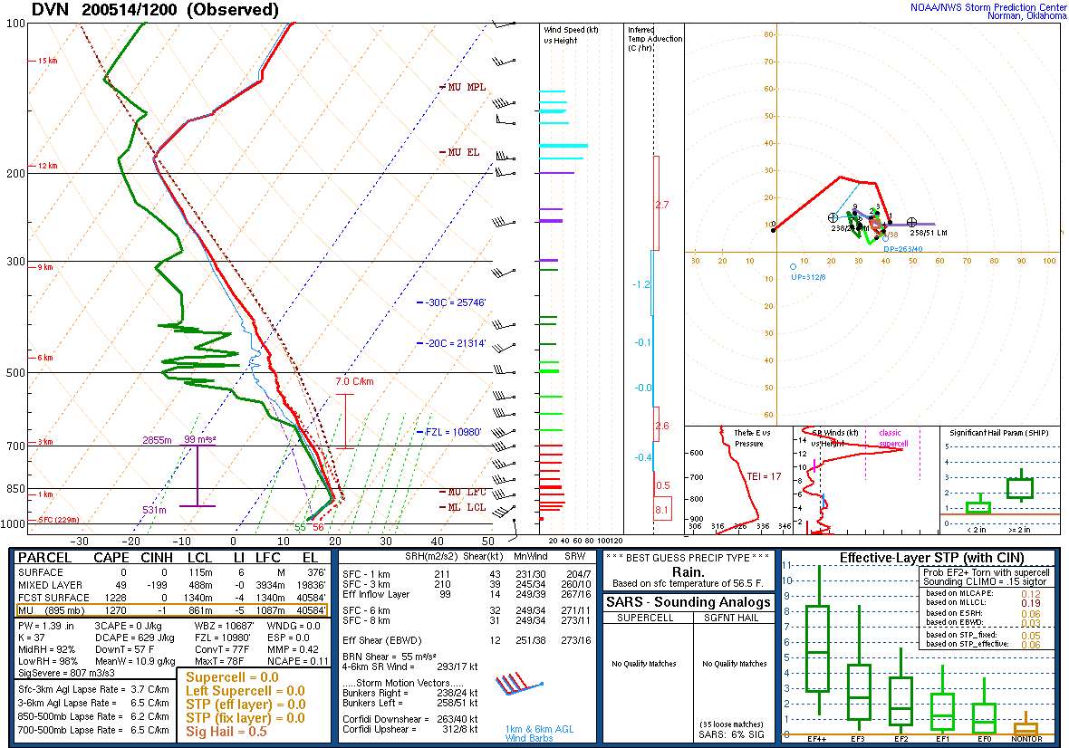
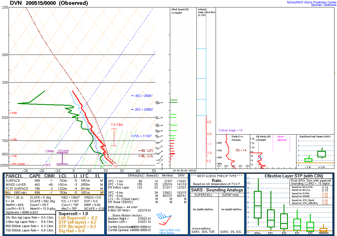
| Figure 5: Excessive Rainfall Outlook | 12z 5/14 Davenport Sounding | 00z 5/15 Davenport Sounding | SPC Mesoscale Discussion 585 |
 |
 |
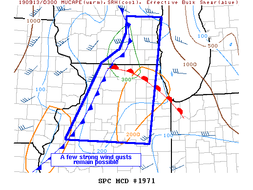 |
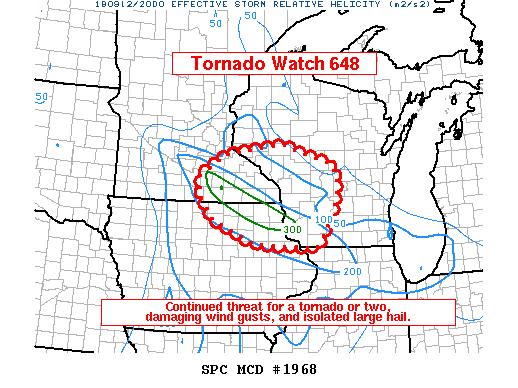
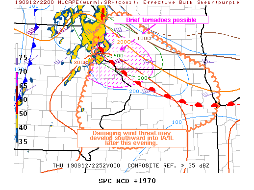
| SPC Mesoscale Discussion 589 | WPC Mesoscale Discussion 190 | WPC Mesoscale Discussion 193 |
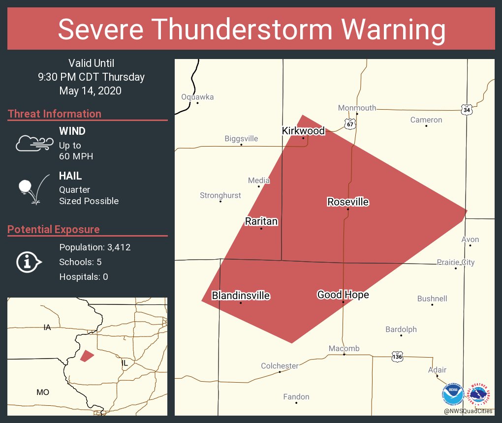
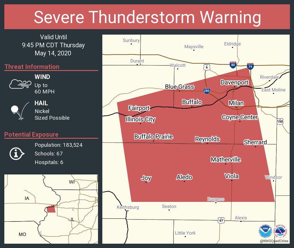
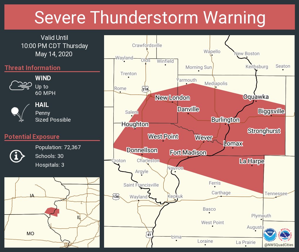
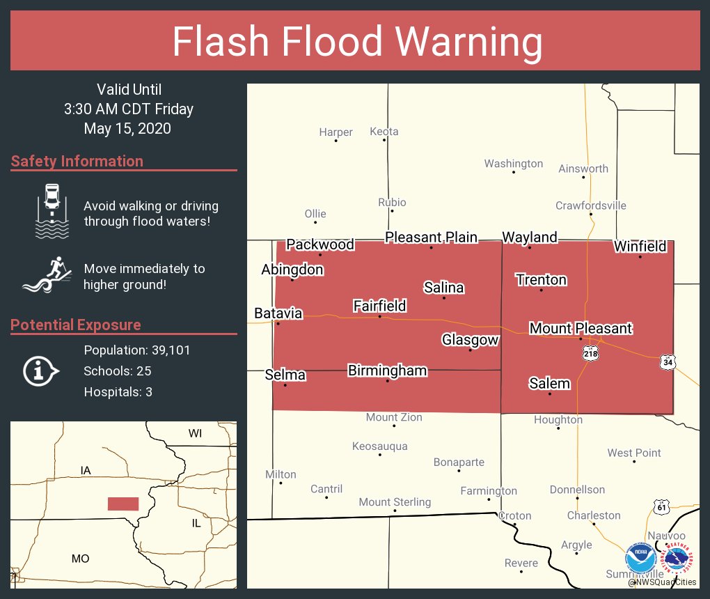
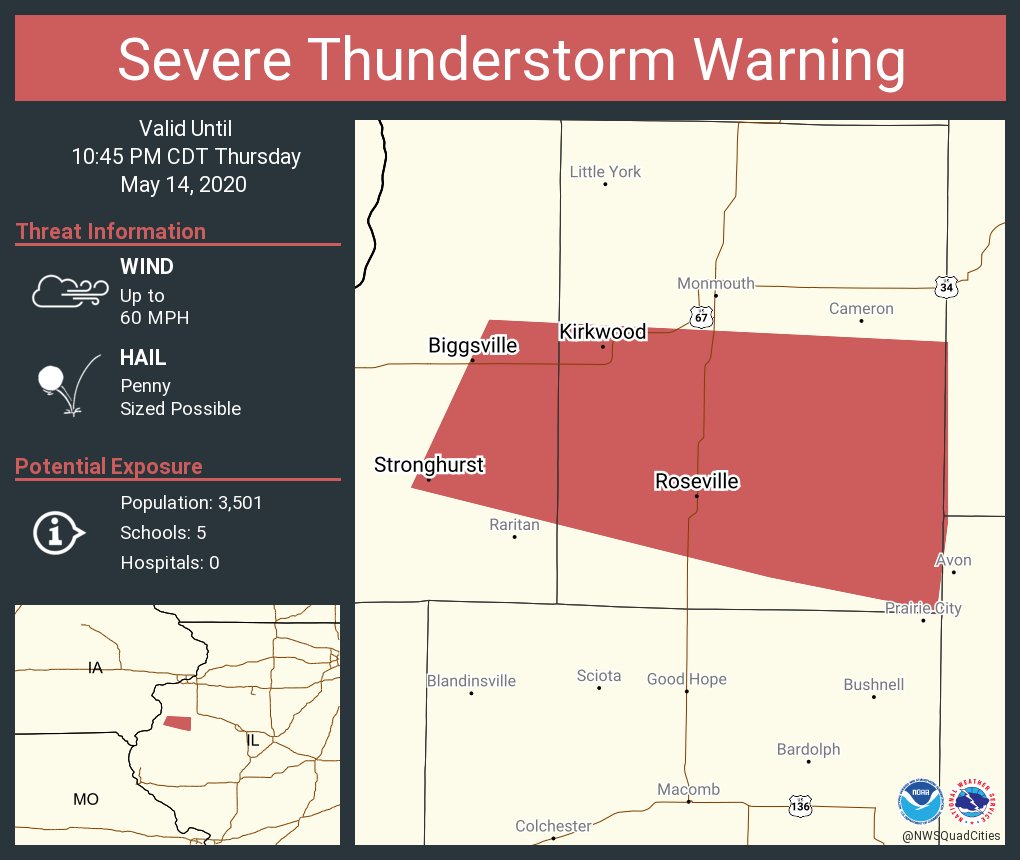
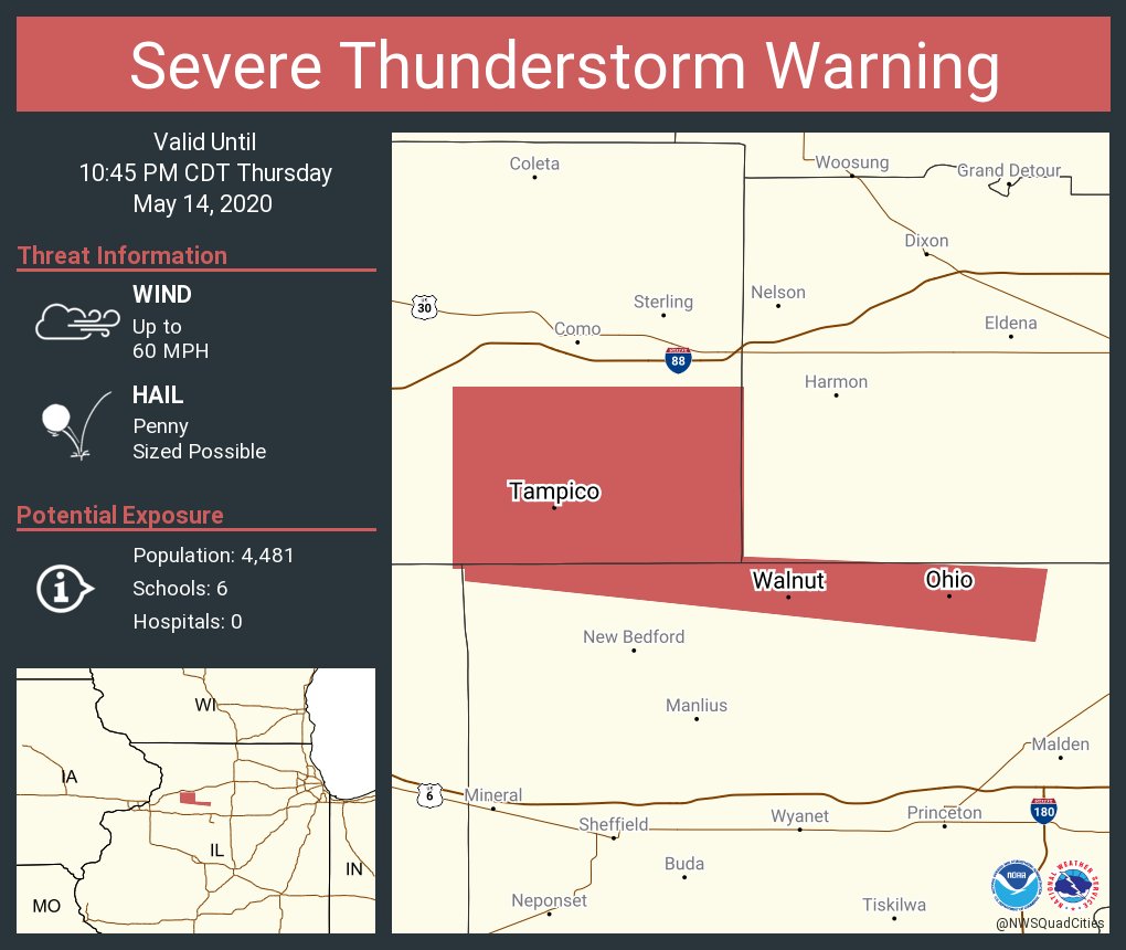
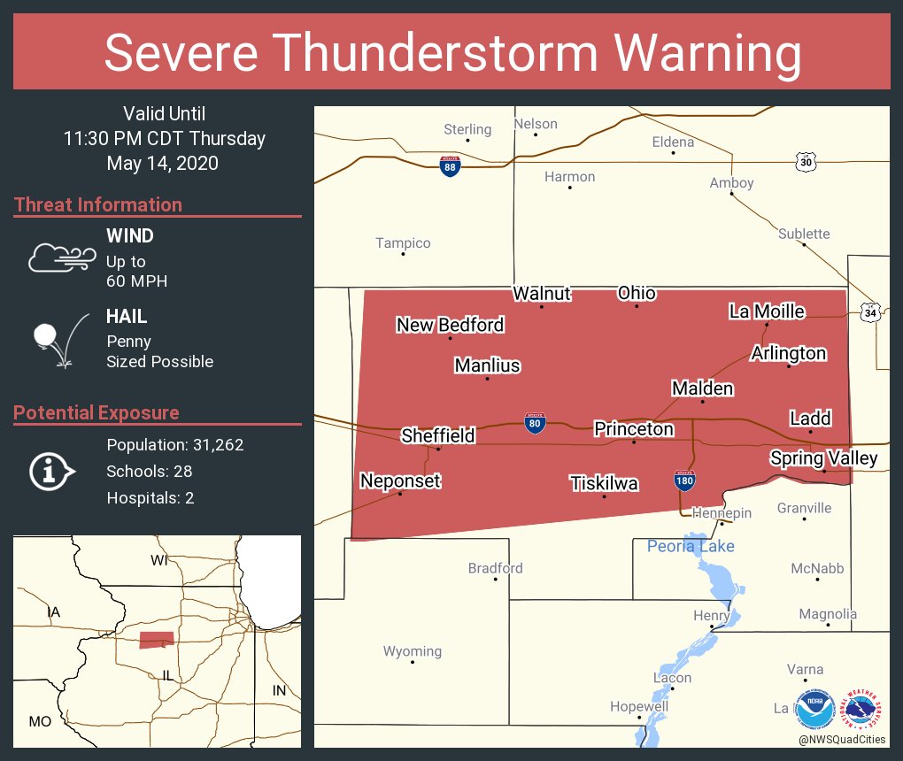
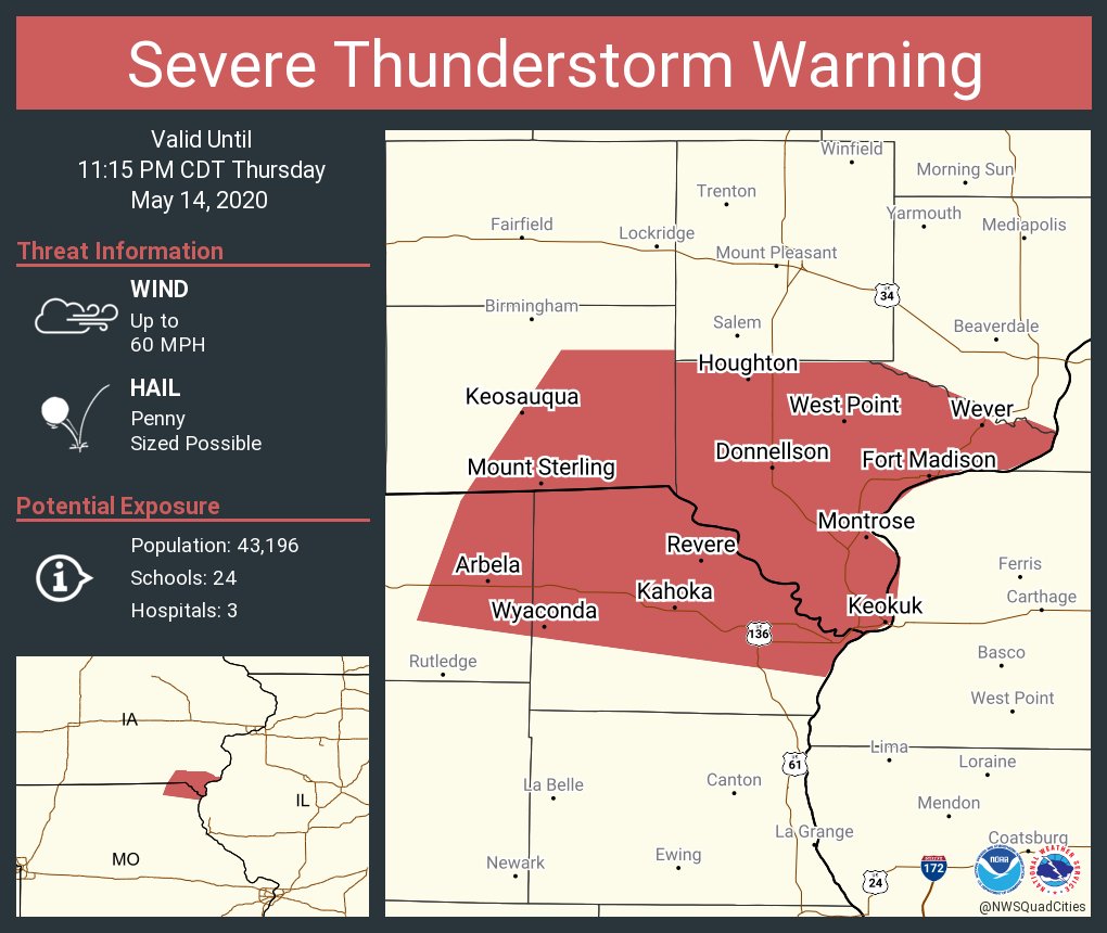
| Warnings | |||
 |
 |
 |
 |
 |
 |
 |
 |
 |
 |
 |
 |
 |
 |
||
 |
Media use of NWS Web News Stories is encouraged! Please acknowledge the NWS as the source of any news information accessed from this site. |
|