Showers and thunderstorms will be possible from the northern Plains to the Gulf Coast on Monday. Thunderstorms with large hail and severe wind gusts are expected Monday afternoon and evening across parts of the central Plains. Read More >
|
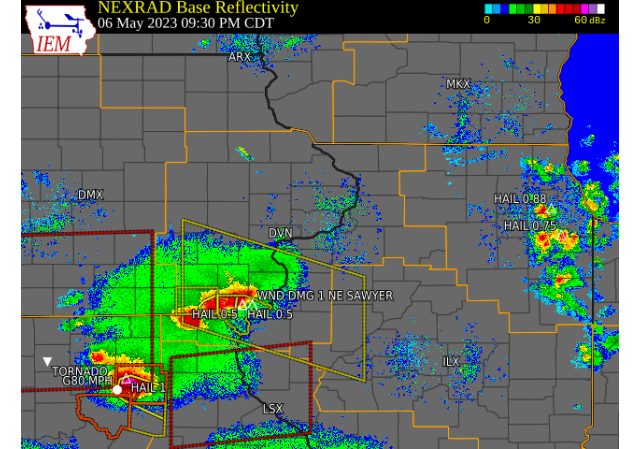
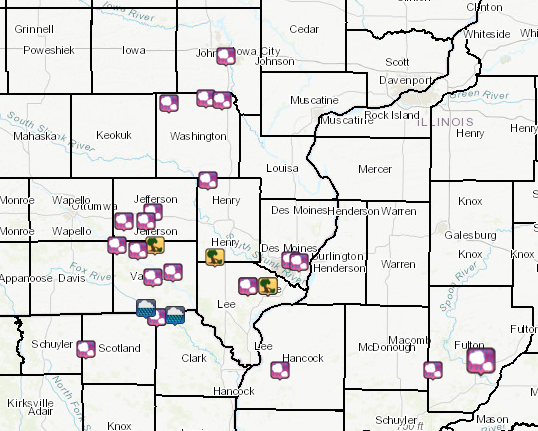
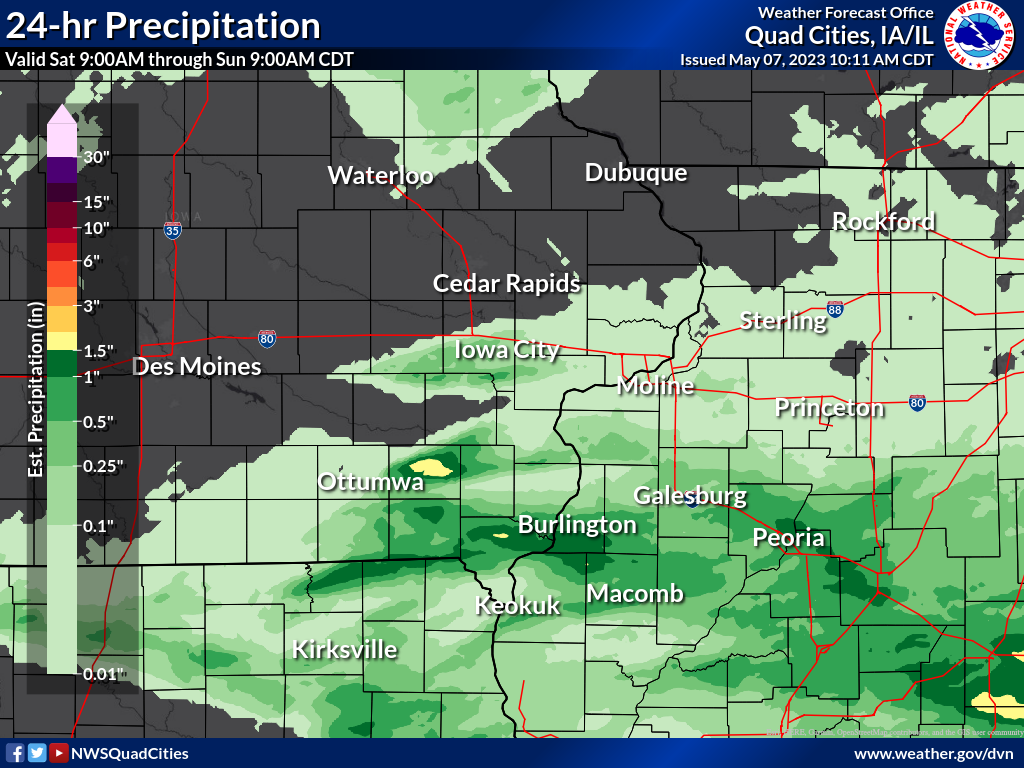
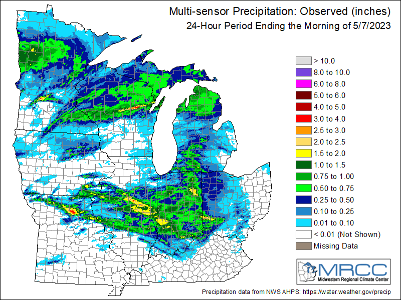
Overview Several severe thunderstorms developed across much of eastern Iowa and northeast Missouri into portions of northwest Illinois on the evening of May 6, 2023. An initial supercell developed across northwest Missouri during the early afternoon hours from the remnants of morning storms to the west. This storm moved across much of the state, producing a tornado along its track. North of this storm, the strengthening low-level jet helped to fire additional showers and thunderstorms, mainly along and south of Interstate 80. Storms mainly produce hailed around half an inch to one inch (quarter size), with one storm in particular in eastern Van Buren County producing hail up to golf ball size. Through the evening, storms merged and weakened in intensity, but not before producing some wind damage across northern and central Lee County. Heavy rain also fell from storms as some remained stationary for long periods of time. Most notably, locations north and east of Fairfield, IA recorded over two inches of rain. |
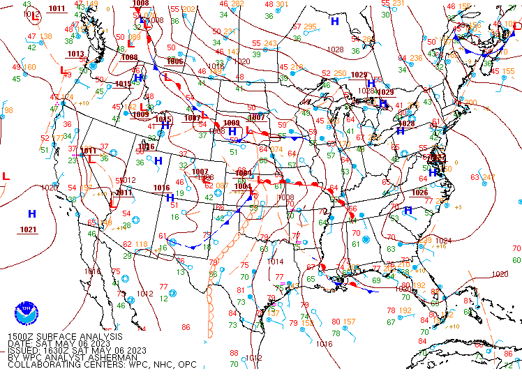
WPC Surface Analysis May 6, 2023 |
Storm Reports
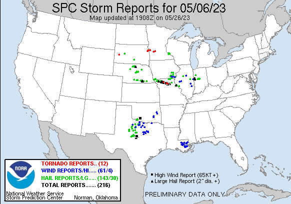
| Storm Reports 5/6 12pm - 5/7 12pm | SPC Severe Weather Event: May 06, 2023 |
 |
 |
PRELIMINARY LOCAL STORM REPORT...SUMMARY
NATIONAL WEATHER SERVICE QUAD CITIES IA IL

..TIME...   ...EVENT...      ...CITY LOCATION...     ...LAT.LON...
..DATE...   ....MAG....      ..COUNTY LOCATION..ST.. ...SOURCE....
            ..REMARKS..
0123 AM     HAIL             WAYLAND                 41.15N 91.66W
05/07/2023  M1.25 INCH       HENRY              IA   PUBLIC
1247 AM     HAIL             2 W CHARLIE HEATH MEMOR 40.58N 91.94W
05/07/2023  E1.25 INCH       CLARK              MO   PUBLIC

            DELAYED REPORT, PEA TO HALF DOLLAR SIZE HAIL
            IN 3 ROUNDS OF STORMS.


1120 PM     HAIL             RIVERSIDE               41.48N 91.58W
05/06/2023  E1.00 INCH       WASHINGTON         IA   BROADCAST MEDIA


1114 PM     HAIL             1 E KALONA              41.49N 91.67W
05/06/2023  E0.70 INCH       WASHINGTON         IA   TRAINED SPOTTER

            CORRECTS PREVIOUS HAIL REPORT FROM 1 E
            KALONA.
1042 PM     HAIL             2 W WELLMAN             41.47N 91.87W
05/06/2023  M1.00 INCH       WASHINGTON         IA   PUBLIC
1041 PM     HAIL             2 SW FAIRFIELD          40.98N 92.00W
05/06/2023  M1.25 INCH       JEFFERSON          IA   PUBLIC
1036 PM     HAIL             2 SSW ELVASTON          40.36N 91.26W
05/06/2023  M0.88 INCH       HANCOCK            IL   PUBLIC


1034 PM     HAIL             3 ESE BATAVIA           40.98N 92.12W
05/06/2023  M1.00 INCH       JEFFERSON          IA   PUBLIC


0959 PM     HAIL             1 SE WEST BURLINGTON    40.81N 91.16W
05/06/2023  E0.50 INCH       DES MOINES         IA   TRAINED SPOTTER


0949 PM     HAIL             1 W WEST BURLINGTON     40.82N 91.20W
05/06/2023  M1.00 INCH       DES MOINES         IA   PUBLIC
0945 PM     TSTM WND DMG     1 S SALEM               40.83N 91.62W
05/06/2023                   HENRY              IA   CO-OP OBSERVER

            TREES DOWN AND SHINGLES OFF ROOF.


0938 PM     HAIL             1 NE SAWYER             40.71N 91.33W
05/06/2023  E0.88 INCH       LEE                IA   TRAINED SPOTTER

            GRAPE SIZED HAIL.

0938 PM     TSTM WND DMG     1 NE SAWYER             40.71N 91.33W
05/06/2023                   LEE                IA   TRAINED SPOTTER

            8 INCH DIAMETER LIMBS DOWN. TIME ESTIMATED.

0933 PM     HAIL             1 ESE WEST POINT        40.71N 91.44W
05/06/2023  E0.50 INCH       LEE                IA   TRAINED SPOTTER


0932 PM     HAIL             1 ESE WEST POINT        40.71N 91.44W
05/06/2023  U0.50 INCH       LEE                IA   PUBLIC

            REPORT FROM MPING: HALF-INCH (0.50 IN.).

0908 PM     HAIL             3 W MOUNT STERLING      40.62N 92.00W
05/06/2023  M0.25 INCH       VAN BUREN          IA   TRAINED SPOTTER


0903 PM     HAIL             3 WSW CRAWFORD          40.45N 92.33W
05/06/2023  M1.00 INCH       SCOTLAND           MO   PUBLIC

            QUARTER SIZED HAIL CURRENTLY FALLING.

0857 PM     HAIL             1 N KEOSAUQUA           40.75N 91.96W
05/06/2023  E0.75 INCH       VAN BUREN          IA   911 CALL CENTER

            SHERRIFF OFFICE RELAYED REPORT OF PENNY
            SIZED HAIL AT HIS RESIDENCE NORTH OF
            KEOSAUQUA. TIME ESTIMATED.

0852 PM     HAIL             2 N BENTONSPORT/VERNON  40.77N 91.85W
05/06/2023  M1.75 INCH       VAN BUREN          IA   PUBLIC

            GOLF BALL SIZE HAIL NOW FALLING AS STORM
            SEEMS TO BE GROWING IN STRENGTH.

0825 PM     HAIL             3 NE DOUDS/LEANDO       40.86N 92.04W
05/06/2023  M1.25 INCH       VAN BUREN          IA   PUBLIC

            A FEW HALF DOLLAR SIZED HAIL STONES NOW
            FALLING AT THE TIME OF THIS REPORT.

0817 PM     HAIL             1 NNW SELMA             40.88N 92.16W
05/06/2023  M1.00 INCH       VAN BUREN          IA   PUBLIC

            QUARTER SIZED HAIL NOW FALLING WITH VERY
            STRONG WIND GUSTS CAUSING MINOR TREE DAMAGE.
|
|
Rain Reports
| Local Rainfall Map | MRCC Regional Rainfall Map |
 |
 |
|
24 hour precipitation reports (in Inches), for |
|
|
....IOWA.... |
....ILLINOIS.... |
Environment
SPC Severe Weather Event: May 06, 2023
| 1630Z SPC Day 1 Categorical Outlook | 1630Z SPC Day 1 Tornado Outlook | 1630Z SPC Day 1 Hail Outlook | 1630Z SPC Day 1 Wind Outlook |
 |
 |
 |
 |
| Mesoscale Discussion 690 | Mesoscale Discussion 694 | Mesoscale Discussion 699 | Mesoscale Discussion 700 |
 |
 |
 |
 |
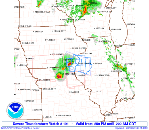
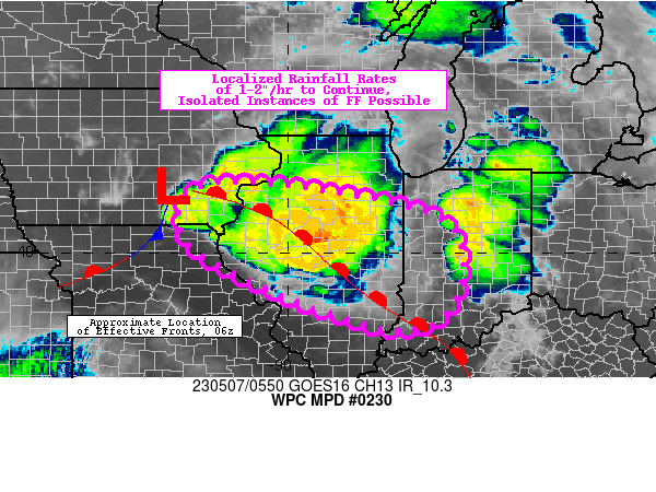
| WW 191 | WPC MPD 0230 | ||
 |
 |
||
 |
Media use of NWS Web News Stories is encouraged! Please acknowledge the NWS as the source of any news information accessed from this site. |
|